System off SE Coast... Surfs Up FL ... Windy... Hurricane Season 2 Months Away. Are You Ready? Amber Sunsets and Some Thoughts on Moving Towards April.

Going to talk on the system off the SE Coast.
And talking a bit on hurricane season.
Along with a few other things for various reasons.

Before I talk on this further note....
That huge storm off the NW coast.
That is not a hurricane...
It's cyclonic....
Winter weather is far from over.
Even though we are dipping our toes into Spring.
Today off the SE coast is a small system.
Up close you can see it below.

See the tight gradients along the NE FL coast?
This is a system that is coming together.
TWC is on the scene.
Surf's up.
Windy.
Stormyish.
Locals are barely talking on it.
But for weather people it's weather.
Guessing they are shooting videos for Daytona Beach...
..future episodes about NASCAR or ??
If they had been in Cocoa Beach they'd have seen hail!
Huge hail.
But one day the ground was covered with hail.
I mean as in huge hail stones....
No green school yard it was all white like snow.
Happens...
Mike knows it happens.
When I was a kid in Miami I never saw snow.Florida city sees so much hail it looks like piles of snow https://t.co/gIfzPI8O3V via @10NewsWTSP— BobbiStorm (@BobbiStorm) March 27, 2019
But one day the ground was covered with hail.
I mean as in huge hail stones....
No green school yard it was all white like snow.
Happens...
Mike knows it happens.

Mike's Facebook Page has the video.
In a month of so another similar system could get a name.
Subtropical Storms are always possible there in May.
It's April in 5 days.
De Facto April today.

This loop shows the story.
Freezing cold clouds to the North.
Warmer water to the South.
Tail end of fronts...
Swirls that get stuck..
Swirls that swim up along the coast.
Caught in a busy flow so out to sea.
But things begin to change day by day now.
Beach by beach the waters warm up.
My brother posted this picture he took from a S FL beach.

He obviously went to the beach early.
Wind not as strong in Miami-Hollywood area.
But that sense of weather out there somewhere....
Ironically Jo Malone sent me this advertisement seconds later.

So I'm naming that picture of his Amber Sunrise :)
I have a love hate relationship with Jo Malone.
Most of the scents I hate or they hate me.
Way too strong, expensive
And sometimes just so wrong.
But sometimes they get it so right.
I have allergies so......
... have to try them on carefully.
Beautiful packaging.
If I had the money I'd buy it for the packaging.
Silly huh?
That's kind of how I feel about TWC being in Daytona.
It's not that strong a storm but hey if you have the money.
You fly off and stand on the beach looking serious :)
And do live updates.
Choose wisely which beach to travel this time of year.
If you want wind... OBX is always good.
If you want warm water... South Beach is always good.

For today Daytona is definitely breezy.
Multiple alerts for high surf and rip currents.

As for my local beach which basically is Wrightsville in NC
(when not in Miami...)

They have a link on their site to water temperatures.
Rising water temperatures coming.
That link takes you to this page below.
This is why OBX usually gets hurricanes in August and September.
Doesn't really get bath tub like until then.
But each year is unique in it's own way.

Link to Wrightsville Beach NC NWS

That's me staring at the water in March of 2017.
It was a rare warm March day.
Headed to the beach.
But didn't go in because not a tourist.
Miami girl in NC ya know...
Back in Miami Beach...........
... the water temperature is 77 degrees!
That's more like it.
Another image from their site is shown below.
Anomalies ...
Gulf Stream warming up.
Beaches near the coast cold still.
Pockets of warm water in the GOM
And just off the Southeast coast.
Prime regions for early development.

Areas to watch in May are same areas in June.
June comes too soon for people who hate hurricanes.
And never too soon for trackers and chasers.
It's kind of like Jo Malone perfume.
Some hate it as it's very strong and often lingers....
.... others love it because it's strong and lingers.
What do you love?
Today I'm in love with the word Amber.
I fell in love with this song below because....
... I loved the lyrics "caramel colored sunset sky"
Awesomeness.
Maybe "amber sunset" needs a country song ;)
Besos BobbiStorm
@bobbistorm on Twitter and Instagram.
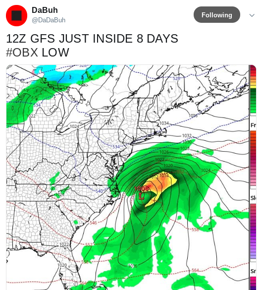
Ps... kudos to Dabuh he's been on the money.
Before The Weather Channel began talking about it.

Labels: amber, countrymusic, Hail, hurricanes, music, perfume, surf, surfers, surfing, temperatures, tropics, water, watervaporloops, weather
posted by BobbiStorm @ 8:17 AM
7 comments
![]()