Hurricane Harbor

A writer and a tropical muse. A funky Lubavitcher who enjoys watching the weather, hurricanes, listening to music while enjoying life with a sense of humor and trying to make sense of it all!

Friday, September 01, 2017

Major Hurricane Irma and the Models. Hurricane History Lesson on the 1960s.


Tropics Friday Morning Above.
Harvey on the move...
Cat 3 Irma moving West.
Possibly Jose behind her.

Close up look at Irma.


Note presence of dry air to it's North
Beautiful storm.
Looks more like a Cat 2 above.
Cat 2 Canes are most beautiful.
I'm talking structure wise...

Putting Irma in perspective.


Now we see the wider picture.
Again look at the dry air to it's North.
(little white dots to newbies)

Still a long way to go.
And Irma could go a variety of places.
Keep it in perspective.
Models below.


Nice product Mike added to his site.
GFS and EURO together at last.


From :


Basically everyone from the Yucatan to the Carolinas in the longer term need to keep an eye on Irma. Beyond that time period in extra long range the East Coast of the US. In the short term the islands really need to pay close attention. Because of the forecast dip to the WSW or even just South of West in reality Irma ends up lower than she would otherwise. Because the High pressure is forecast to dig in, push down on Irma her response is to adjust her forward motion and move a bit more to the south of due west.  This is not so rare in long tracking CV hurricanes. They have a slight motion south of due west, when the high expands. Hurricane Dora in 1964 is an excellent example of how a hurricane responds to the movements of High Pressure. Early on Dora took a slight dip WSW as High Pressure pressed down on her. She kept cruising along and then the High took an unfortunate trip further West and pushed Dora into the Jacksonville area for a rare hit on Jax. Eventually it went out to sea with an obvious front. Dora went down in history for many things; one being a long tracking storm since it's departure from Africa to the North Florida area. 


Note that's a similar bend left as Andrew.


This is an an example of why we watch the High.
As much as we pray for cold fronts.
We watch every fluctuation of the High.
The placement of the High this week...
...will be mirrored by Irma's movements.

This leads us back to the models and Hurricane Irma. The models change and update every six or twelve hours depending on the model. Some models update faster and some make us wake and bite our fingernails waiting to see if there will be some change when they finally strut their stuff late at night when only the more dedicated wait up to see what they will show us on the last model run. And what they show us can change on the next model run. To quote Shakespeare...do not swear by the models, they change constantly especially far out when a storm is closer to Africa than Puerto Rico. And, I use PR as an example as it may be dealing with Irma in some way down the line. There is no hard and set line on Irma's final track; at some point there may be a line on it in Vegas where people will bet on anything. I'm not a gambler, other than once in a blue moon buying a lotto ticket, but if I was I would not bet the farm on Irma making it to the East Coast as percentage wise most hurricanes that form where Irma has formed go out to sea. But it's the ones that do not that live in infamy and in our collective memories.


Some decades are known for extreme hurricane action and Hurricane Dora lived in the Swinging 1960s when hurricanes happened often in America as they found a way to make it across the pond and into landfall history.  The map below is the year of 1964 and you can discern many things from that map. One is that many originated near Africa and most of those went out to sea. Dora did not go out to sea until after taking a rare track across an area that usually feels safer than most along the Florida coast. Cleo made a similar lower track across the Atlantic first tasting blood in the Caribbean leaving a high death toll. It also is a storm to watch historically with regard to the long range projections for Irma. The track is shown below as well. Again you will see the movement of the High is shown by the actual track of Cleo as if she simply traced the high as she moved about.


Cleo.


This is why many storm chasers, trackers and forecasters talk on the 1960s. It was a decade to remember from Donna in 1960 to Camille in 1969. It's been quiet times in the tropics of late as El Nino was on the scene and reigned as King for a several years. We tend to forget in quiet years that hurricanes along the East Coast happen. We look back at Sandy as if it was a long time ago and a benchmark of sorts. Many think those days of multiple landfalls are gone and most hurricanes will simply form and go quietly out to sea. Wrong; it's just the way our minds work and we remember the recent past more than we remember the whole spread of hurricane history. 

The crazy 1940s where some sort of hurricane was expected to form and drench South Florida every year. My father went to the UM and lived on Miami Beach often and every year he had to evacuate for a summer hurricane. One year the University insisted students living on Miami Beach not stay and offered them rooms near the airport by some sort of zoo their students used. The storm caused massive flooding inland and after that he stayed in his rented room on Miami Beach happier than deal with inland flooding. We will talk about that famous 1940s hurricane in another blog soon as some have pointed to it as an analog storm for Irma.


Back to Irma.

rb-animated.gif (1120×480)

She's dancing out there today.
That loop deserves the right sound track.


This is the issue.
Not the models.
But the forecast strength.

Note discussion below:


The 5 Day Forecast.
140 MPH.
WOW.


If that doesn't wake you up you're not alive.
It's stronger than caffeine.

Often the NHC changes like the models.
So don't bet on it but...
... wow. 

Bottom Line.... stay tuned. Watch the progress over the next few days before you lose any sleep on Irma and stay on top of your hurricane plans should your city move into this five day window. For now she is far away. Never forget history, we learn from history and sometimes it repeats or comes close to repeating. Double landfalls such as Betsy and Andrew across South Florida into Louisiana are rare but happen as a strong High breathes and expands outside it's normal boundaries and pushes a hurricane further west than most that go out to sea. With regard to Donna, it moved into the GOM and then back across Florida with a cold front. 

I'll be back later with another update later today. Thanks for reading and for sharing your thoughts on Twitter and being patient while I was dealing with ridiculously slow "free wifi" at JetBlue's terminal at JFK.  But it was a wonderful trip on many levels and a good chance to breathe a bit myself as I was up late and worried on Harvey as it moved towards the Texas coastline as I knew... we knew... this was not one that was simply going to go along and follow the more common track out of the BOC into Mexico.  Nope... and Irma may not go out to sea, even if most hurricanes where she is currently do go out to sea. 2017 seems to be one of those seasons.

Besos BobbiStorm
@bobbistorm on Twitter

Ps... I'll be back later today with another update.


Labels: , , , , , , , , , , , , ,

Thursday, July 27, 2017

Tropics Today 30% Yellow. A Week From Now Might Have Real Trouble. Models. Discussion. A Look Back at July 2012 and SAL Killing Off Waves... and Hurricane Sandy.


Going to do a quick over view of the Atlantic Tropical Basin this morning before going into any other matters. We have a yellow 30% circle over the Atlantic. It's not really important to show it as you know what it looks like ... it's a yellow long swatch. It's closer to Africa than the Islands and the NHC has added in spaced out yawns in their discussion showing their less than stellar enthusiasm. But I do feel it's a good spot to put the yellow swatch across an area that has potential to soon produce a tropical entity. When I say entity I mean something with designation. Maybe it will produce an Invest (first step in the process where we "investigate" a wave officially) or even a tropical depression. Definitely a "tropical disturbance" meaning more than a wave, but less than a tropical storm. And it's not impossible to see a Tropical Storm develop from a series of new waves that are currently rolling off of Africa. It's also likely it gives it up to SAL which is still the villain or the hero of the Atlantic depending on your perspective. Think of SAL as Sheriff Sam trying to lock up westbound waves before they can cause any real trouble.


I'm going to put up the discussion rather than the graphics as the discussion says more. So at 2 AM the discussion said this about that yellow area:

Compare and contrast that with the 8 AM discussion below:

Subtle differences.
Beven speaks on specifics in the 2 AM
Avila gives a vague view at 8 AM.

My thought on this wave is that it is moving extremely slow. Five to Ten miles per hour forward speed is slow enough for it to tweet and blog while lumbering along. There's even time to edit the blog at that slow speed. The wave behind it may come off faster and over take this wave, absorbing part of it's moisture and it's something to think on as it exists Africa and jumps into the Atlantic Ocean. You can see the trio of waves over Africa in the map below. I will say this about the models and nothing more; some models do a better job of developing the wave over Africa and keeps it alive further down the line. The models that loved this wave a few days ago have backed off so far except for the CMC that does still love this wave. The Euro develops a wave in more than a week's time. Which wave exactly of the Trio over Africa is the wave that pops is the question?


Again the map below shows the Atlantic.
The waves over Africa.
The Highs and the Lows.
All the features you need to know about.

I'm showing this map above as it always starts with a map. Once something is put onto a map it exists. It is no longer a tree in the forest that no one saw fall and no one tripped over.  This image is near the top on www.spaghettimodels.com for a reason. It's a pirates map of possible treasure. It shows where the Lows are and the vertical lines near the ITCZ are in fact the placement of actual waves. It also shows the High pressure that the waves (areas of weak low pressure) often stay away from as they travel west. And it also shows the track any storm would take currently should it be introduced onto the map.  Notice the multiple Lows about to depart Africa. Some are a bit higher than others.

The true Cabo Verde season begins when the waves depart Africa around a beach at Dakar. Climotologically speaking that is where we want them to roll off however in June and July they come off lower. Despite how beautiful they look they are less likely to develop and if they have minimal development they will go where Bret and Don went before them. And most of the best waves crash onto the beaches of South America. To get to North America you need them to come off higher and for frontal boundaries to start moving across the higher latitudes. For example, this week a stronger than usual cold front is forecast to move down across the SE providing huge relief from the constant summer heat. A cold front in late July? It happens sometimes and it does provide relief temperature wise but after the first cold front dips you will notice the tropical waves begin to lift off the monsoon trof faster and in doing so they pick up some spin and begin to move WNW vs just west towards South America. Nuff said. I'll show some maps regarding the cold front later in this blog with regard to a Low that could form off the Carolinas.

The best way to look at the wave in the East Atlantic is really by way of the Saharan Dust Layer image as it shows up nicely trapped there somewhat surrounded on three sides by SAL.


You can see it has some low level or mid level spin.
It actually looks better than I expected.
The yawns from the NHC have been loud.
If it was snoring they'd need breathing masks.
This is actually a lower level of SAL than before.
At the end of the blog I'll post links worth reading.
SAL happens in July all the time.
Sometimes more, sometimes less.
It portends a few things for later in the season.

Still a long way to go.
The graph below shows the wind flow around the wave.


The wave behind this one is being watched closely.
Models like the next wave. Forecasters like the next wave.


Keep that in mind.

GOM:

wv-animated.gif (720×480)

The spin is from an ULL in the GOM.
There is convection there but nothing expected to develop.
In the upper right is a an area of convection off FL.
There is also an ULL in the Bahamas visible on the WV Loop.
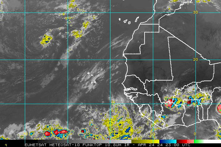
Below is the Funk Top loop.
Shows strong cells of convection better so I'm using it.
Also you can check back over time and watch the front.
Also notice the huge red blob in the Midwest.
There is flash flooding going on now.
And this problem will continue all day.


Notice this is the second front dipping down.
At the tail end of the previous front is an area of spin.
Cradled there off the coast.
Let's look at the radar image.
This is from St. Marys Georgia.
One of my favorite "safe places" to go to breathe.


https://www.accuweather.com/en/us/st-marys-ga/31558/weather-radar/337718

This is an area that normally we would watch for some sort of development. However if that new cold front is as strong as the models say it is then it will scoop this up and take it out to sea. Stay tuned and as always watch what happens to see if the forecast verifies. On Spaghetti Models you can watch this happen on the following two grids.


The Caribbean is quiet with it's normal daily showers.
The Northern Central Atlantic has it's resident ULL 


Currently there is no pulse in the Atlantic.
Lots of convection and some lowered pressure.
But no real closed center. No pulse.


With regard to the cold front models show it on the move.


The front gets that far South.
Then it stalls out and goes Stationary.
Remember during this same time the wave is crawling west.


And note there is eventually a LOW off the Carolinas.
The image below is for August 1st.


Our wave watcher above DaBuh is closely watching that area.

Below is a Flash Flood Warning for Overland Park.
I know that area well my son did an internship there.
Nice people, good community.
Hope they know about the early morning warnings.


Lastly I want to mention the heavy rainfall in Florida so far this summer. Also the extreme high heat. Three inches of rain in an hour is nothing for Miami but in places such as inland Alabama that had flooding yesterday it can be devastating. But Miami is flat and the water flows into the ground through the coral rock into the Biscayne Aquifer below. Three inches of rain in an area with creeks and elevation can be a disaster and create Flash Flooding requiring water rescues.

https://en.wikipedia.org/wiki/Biscayne_Aquifer

Normally when you have such extreme heat (strong high) and higher than normal rain totals South Florida is being set up for a hurricane or tropical storm later in the hurricane season. Most often this occurs with a storm coming in from the South as early cold fronts can attract wandering tropical entities that moved west around a strong High into some part of the Caribbean and then gets swept up towards Florida and beyond. For example let me mention Hurricane Sandy to remind people what most people have forgotten. Hurricane Sandy affected Jamaica and Cuba way before it took aim on on New York Harbor. So check back often at Hurricane Harbor here (not the amusement part) and get your daily feed of tropical information. History tidbit here is 2012 was an extremely HOT year and the summer in many areas was unbearable. What we in Florida call Hurricane Weather....

http://hurricaneharbor.blogspot.com/2012/10/hurricane-sandy-makes-landfall-near.html

Actually long range models did show Sandy making it to the NE but where was the question and many laughed at that idea. No one laughs when you say Hurricane Sandy anymore.

Cuban discussion of Sandy is below:

http://hurricaneharbor.blogspot.com.es/2012/10/unprecedented-damage-from-unprecedented.html

Note what I wrote about Sandy at that point in time.
"Hurricane Sandy will be Hurricane Sandy... that is the bottom line..."

http://hurricaneharborr.blogspot.com/2012/10/hurricane-sandy-cold-front-all-about.html

Then post game discussion. Lastly I want to mention that there was a huge outbreak of SAL that summer. I talked about it in July of 2012. Storm chasers were discouraged in 2012 early on because of the strong SAL that was killing off the waves. Mother Nature had the last laugh. So remember that before writing off this particular hurricane season.


Okay so with that in mind we know what song we will play.

Besos BobbiStorm
@bobbistorm on Twitter.
Follow me on Twitter for faster updates.
And join in the discussion.
Thanks for all the interesting hurricane memories yesterday.
What hurricane was your first hurricane?


Ps Extra credit for anyone who made it down here.
Is she adorable?
Not cause she's my granddaughter but...
...because look at that attitude!
She's in LA and ready to go swimming!!


If Victoria's Secrets had a site for children.
She'd definitely be the best model ;)
Pink beach shoes and all.
And she loves their perfume.


Labels: , , , , , , , , , , , , , , ,

Wednesday, June 14, 2017

20% Cape Verde Wave + 20% Yucatan - Tropics Heating Up. Model Discussion ...Waiting on Floaters or Invest Designation.


Even from far away....
...you can see what I'm talking about today.


Up close view below of the Cape Verde Wave..
..and the one behind it!
One in the water with 20% yellow.
Another over land waiting to depart..

ft-l.jpg (720×480)

A new yellow circle off of Africa with 20%.
CV Wave with 20% chances in June.
We say June too soon but not for yellow circles.
Where yellow circles go tells the story.
The 20% Yellow circle is now over the Yucatan.
Connect the dots.
West to WNW under the high pressure...
...towards the Islands, East Coast & GOM.
That is the pattern the experts have predicted for this year.


From the Indian Ocean....
...to the Atlantic Ocean.
Tropical Waves are well spaced.
And they are moving West.

Back on our side of the world...

wv-animated.gif (720×480)

The Euro this morning likes the GOM.
I promised you models today so here we go.


Low forms over the tip of the Yucatan... Mondayish
New models aim it higher up the coast.
Makes landfall near Houston below.


It hooks more to the right on the next frame.
My main point is watch the trend.
Watch the High.

The GFS however....
Forms a low and loses the low.


Note the presence of Lows in the Atlantic.
NOTE THE HUGE HIGH.

Then on June 30th...


On June 30th... another Low Departs Africa.
Nothing made landfall in BOC or GOM.
The HUGE HIGH is STILL THERE.

Regarding the area the NHC has highlighted with a yellow circle near the Yucatan... something might develop four or five days from now, but for now we are just watching it. As the Euro is now eyeing the Texas coast as a possible landfall of a weak system it is definitely worth watching and spending time talking about here in the blog. If you live anywhere along the Texas coast pay attention as things go pop close to the coast often in June and July. And models come and go and change the track of potential storms that have not developed yet. Today it's Houston and tomorrow it could be Brownsville or tomorrow the Euro could drop it altogether. 

Once we see something develop I can go long on models and possibilities. We don't even have an Invest designated or a floater for either area being watched. If we do I'll update the blog obviously, but for now what is important is the pattern and that pattern is the huge high that dominates the Atlantic. I'll say it again... DOMINATES to the degree it should be nicknamed "The Dominator" as it will be a huge factor in steering any well developed Cape Verde Waves that form later in the season. To even be talking about possibly viable waves in June is a sign of how busy this season can become in August and September and I'll add July may be a wild ride in the tropics this year. There are always mitigating factors, but we rarely have a set up with so many signs indicating a busy season. Also remember a busy season can also bring weak storms battling shear or fish storms if the High moves East or a break opens up in the High later in the season. 

sat_ir_enh_east_loop-12.gif (640×512)

Note above we still have fronts moving across the US.
The convection on the South side of Central America.


You can see how bottom heavy the convection is..
Hard for me to see development in BOC currently.
But by Monday or Tuesday possibly.
Even Sunday is a possibility.

Again just cause you can't see em today..
..doesn't mean it won't form and bite you!

You don't have to see em to be bit by em ...

GOM and BOC are prone to fast spin ups.
So stay tuned on that one.
Another voice shown below. 
Vorticity is the first key to development...
It's what the models are sniffing for...


Bobbistorm's Bottom Line:

First thing you notice with this models is the strength of the HIGH on the  models.

The waves may be weak and areas of interest invisible but the High is not, it's huge.

When you have a high that strong it becomes a major steering factor for the Hurricane Season.

Things change down the tropical road and on any given day it weakens. But watch the trend.

We love to watch to see if a system pops up, but watch the whole pattern...watch the high!

Later in the season Upper Level Lows will pop up and add in steering patterns for named storms.

This is the time when you should prepare and make sure your coverage is up to date and you have the supplies you may need should you find yourself suddenly inside a cone and under a warning of some kind.

I'll update later as the NHC updates. If an Invest forms or a floater is designated I'll be back later today. 

And lastly prayers for everyone affected today by the horrible shooting in the Washington DC area this morning. Weather like news has a way of popping up and dominating the news suddenly when you least expect it. A practice for a baseball game on a Wednesday Morning doesn't seem very newsworthy and then sadly it becomes the big, terrible story of the day. A weak wave in the Atlantic or small swirl offshore barely noticed can become a strong named storm just as fast if conditions change. The possibility of danger is always present in today's world and the possibility of development of a bothersome early June named storm also happens when you least expect it as June really never is too soon despite the old Hurricane Poem. Alexandria Virginia may seem a safe, nice place to live or safer than DC, however trouble happens everywhere. Hurricanes happen so always stay connected to your favorite news and weather sources.


One morning you wake up and Spaghetti Models has an image from the NHC showing something is happening. Stay informed. He has a link to an App for your phone if you wish and as always the NHC is the real bottom line on the tropics. My thanks to Levi Cowan for the awesome job he does with Tropical Tidbits (where I took the images from for my model discussion) and as always Jim Williams of Hurricane City fame. 

Besos BobbiStorm
@bobbistorm on Twitter. Follow me for more immediate updates in real time.

Song for the day:


Labels: , , , , , , , , , , , , ,