20% Cape Verde Wave + 20% Yucatan - Tropics Heating Up. Model Discussion ...Waiting on Floaters or Invest Designation.

Even from far away....
...you can see what I'm talking about today.

Up close view below of the Cape Verde Wave..
..and the one behind it!
One in the water with 20% yellow.
Another over land waiting to depart..
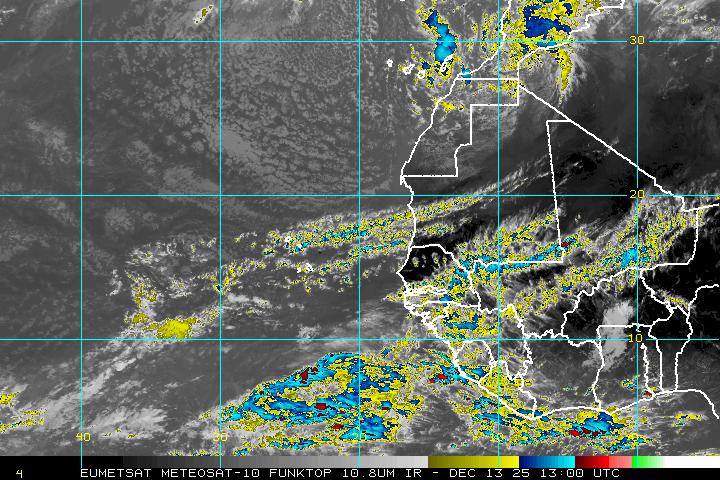
A new yellow circle off of Africa with 20%.
CV Wave with 20% chances in June.
We say June too soon but not for yellow circles.
Where yellow circles go tells the story.
The 20% Yellow circle is now over the Yucatan.
Connect the dots.
West to WNW under the high pressure...
...towards the Islands, East Coast & GOM.
That is the pattern the experts have predicted for this year.

From the Indian Ocean....
...to the Atlantic Ocean.
Tropical Waves are well spaced.
And they are moving West.
Back on our side of the world...

The Euro this morning likes the GOM.
I promised you models today so here we go.

Low forms over the tip of the Yucatan... Mondayish
New models aim it higher up the coast.
Makes landfall near Houston below.

It hooks more to the right on the next frame.
My main point is watch the trend.
Watch the High.
The GFS however....
Forms a low and loses the low.

Note the presence of Lows in the Atlantic.
NOTE THE HUGE HIGH.
Then on June 30th...

On June 30th... another Low Departs Africa.
Nothing made landfall in BOC or GOM.
The HUGE HIGH is STILL THERE.
Regarding the area the NHC has highlighted with a yellow circle near the Yucatan... something might develop four or five days from now, but for now we are just watching it. As the Euro is now eyeing the Texas coast as a possible landfall of a weak system it is definitely worth watching and spending time talking about here in the blog. If you live anywhere along the Texas coast pay attention as things go pop close to the coast often in June and July. And models come and go and change the track of potential storms that have not developed yet. Today it's Houston and tomorrow it could be Brownsville or tomorrow the Euro could drop it altogether.
Once we see something develop I can go long on models and possibilities. We don't even have an Invest designated or a floater for either area being watched. If we do I'll update the blog obviously, but for now what is important is the pattern and that pattern is the huge high that dominates the Atlantic. I'll say it again... DOMINATES to the degree it should be nicknamed "The Dominator" as it will be a huge factor in steering any well developed Cape Verde Waves that form later in the season. To even be talking about possibly viable waves in June is a sign of how busy this season can become in August and September and I'll add July may be a wild ride in the tropics this year. There are always mitigating factors, but we rarely have a set up with so many signs indicating a busy season. Also remember a busy season can also bring weak storms battling shear or fish storms if the High moves East or a break opens up in the High later in the season.

Note above we still have fronts moving across the US.
The convection on the South side of Central America.

You can see how bottom heavy the convection is..
Hard for me to see development in BOC currently.
But by Monday or Tuesday possibly.
Even Sunday is a possibility.
Again just cause you can't see em today..
..doesn't mean it won't form and bite you!

You don't have to see em to be bit by em ...
GOM and BOC are prone to fast spin ups.
So stay tuned on that one.
Another voice shown below.
Vorticity is the first key to development...
It's what the models are sniffing for...

Bobbistorm's Bottom Line:
First thing you notice with this models is the strength of the HIGH on the models.
The waves may be weak and areas of interest invisible but the High is not, it's huge.
When you have a high that strong it becomes a major steering factor for the Hurricane Season.
Things change down the tropical road and on any given day it weakens. But watch the trend.
We love to watch to see if a system pops up, but watch the whole pattern...watch the high!
Later in the season Upper Level Lows will pop up and add in steering patterns for named storms.
This is the time when you should prepare and make sure your coverage is up to date and you have the supplies you may need should you find yourself suddenly inside a cone and under a warning of some kind.
I'll update later as the NHC updates. If an Invest forms or a floater is designated I'll be back later today.
And lastly prayers for everyone affected today by the horrible shooting in the Washington DC area this morning. Weather like news has a way of popping up and dominating the news suddenly when you least expect it. A practice for a baseball game on a Wednesday Morning doesn't seem very newsworthy and then sadly it becomes the big, terrible story of the day. A weak wave in the Atlantic or small swirl offshore barely noticed can become a strong named storm just as fast if conditions change. The possibility of danger is always present in today's world and the possibility of development of a bothersome early June named storm also happens when you least expect it as June really never is too soon despite the old Hurricane Poem. Alexandria Virginia may seem a safe, nice place to live or safer than DC, however trouble happens everywhere. Hurricanes happen so always stay connected to your favorite news and weather sources.

One morning you wake up and Spaghetti Models has an image from the NHC showing something is happening. Stay informed. He has a link to an App for your phone if you wish and as always the NHC is the real bottom line on the tropics. My thanks to Levi Cowan for the awesome job he does with Tropical Tidbits (where I took the images from for my model discussion) and as always Jim Williams of Hurricane City fame.
Besos BobbiStorm
@bobbistorm on Twitter. Follow me for more immediate updates in real time.
Song for the day:
Labels: African, bermuda, Brownsville, GOM, High, Houston, hurricanes, models, prayers, storms, Texas, tropics, Waves, weather
posted by BobbiStorm @ 6:41 AM
![]()


0 Comments:
Post a Comment
<< Home