Hurricane Harbor

A writer and a tropical muse. A funky Lubavitcher who enjoys watching the weather, hurricanes, listening to music while enjoying life with a sense of humor and trying to make sense of it all!

Sunday, June 10, 2018

Hurricane History. Long Read. Watch the Videos.. Listen to the WIND... Hurricanes & The Florida Keys. Often What Happens in Florida Doesn't Stay in Florida ... It Ends up In NC NJ NY NE...


Can you name that Hurricane?

There really is nothing new under the sun and that is especially true when we are discussing weather in the tropics. In truth tropical storms as well as the Big Daddy of tropical systems the Hurricane do visit far away beaches in New England and on Long Island but what starts in the tropics doesn't always stay in the tropics. And whatever has happened in the past will repeat itself in the future with some minor variation so if you don't learn from history you really are doomed to have your little island paradise blown away by the next Major Hurricane. 


Now days we track online and follow the hurricanes on our Smart Phones yet as much as we have changed the way we follow hurricanes with incredible satellite imagery and models that get better at nailing down the track the hurricane remains the same. Rain, wind, squalls moving in tandem in a storm that is spinning like a top traveling across an ocean looking for a place to make landfall. Sometimes a weak tropical wave battling wind shear and dry SAL manages to pull itself together just enough to attain named status while the NHC debates downgrading it to depression status. A few days later it pulls together once past the SAL and the wind shear and develops rapidly changing direction suddenly and taking aim at South Florida and the Miami area from the East. The picture above is from a book that talked on the Great Labor Day Hurricane yet it could just as easily have been talking about Hurricane Andrew. 


Above was 1935
Below was 1960


Hurricane Donna made landfall in Marathon in the Florida Keys before going on to hit multiple cities in her long race to victory that ended up with people in New York getting hit by the same hurricane that made landfall in the Florida Keys. Before the Florida Keys it threatened the islands and flirted with Cuba, but for this blog's purpose we are focusing on the Florida Keys. In 1935 the Labor Day Hurricane made landfall close to Donna's landfall point but a bit further to the North around Long Key. Hurricane Betsy in 1965 made landfall in the Upper Keys though if you check it out online you may read it hit Louisiana. The point here is that history is often local from the perspective of the person viewing the history. I typed "Hurricane Donna Florida Keys" into the browser and hit images and multiple images appeared including one of a lady standing in what looks like her winter coat on the high steps of her front porch and I thought "no that's wrong" as Google found "Hurricane Donna" but Hurricane Donna was also New York's hurricane to remember. 

In Miami people worried on Hurricane Betsy and they prepared the same way we do now days even though that was a half a century ago. Yes, our satellite imagery is better and we have models that though they argue often give us a better handle on changing steering currents. We sample the air around the storm and well I'd like to think if we had the tools in 1965 that we have now we would have been able to forecast Betsy's loops. Then again maybe not as hurricanes by their very nature are erratic and difficult to pin down. That is why people spend lifetimes studying Atlantic Hurricanes as if they are looking for lost treasure or the Holy Grail. The real Holy Grail is Intensity Forecasting, the kind that would predict Hurricane Aletta's sudden intensification to Category 4 from seemingly out of nowhere. 


Before Hurricane Irma ever took aim on the Florida Keys after flirting with the Cuban coast history books are filled with the same scenario with regard to multiple hurricanes that did the same thing. Yes, each is different in some way but the track of a hurricane moving slowly blocked to it's North by a strong Bermuda High slowing down as it approaches and waiting patiently for the Bermuda High to give it's a pass and move a bit to the East so that like the old "Open Sesame" story the Hurricane suddenly lifts NW or WNW towards the Florida Keys.  Back then we didn't have the models we have now and yet even today the same drama holds tight as we hear the models show Hurricane Irma will make landfall near Miami and then Homestead and then the Florida Keys and only in the rear view mirror to we learn there is a place named Cudjoe Key. But to people on Big Pine Key it hit their key and others will look back and say it hit the "Lower Keys" and someone in Key West who lost their roof when part of an old banyan tree fell onto it will tell their grandchildren about the time Hurricane Irma hit Key West. In the part of the Florida Keys where people are trying to put their lives back together while filling out miles of forms they would probably ask Hurricane who when hearing someone ask on Hurricane Georges. Irma is still the Hurricane of the Hour in the Florida Keys.

Cyclone Jim above in Georges.

Hurricane Irma below.


We have changed the way we track and the way we forecast even at times forecasting development before the first bands of a storm begin to come together. Our models hit the mark sometimes and other times an old time forecaster who knows climo and hurricane history does a better job than the models. Sometimes the models are wonderful, sometimes they are crappy but the one commonality is the Hurricane brings the possibility of death and destruction with it as it moves towards landfall. And, a long tracking Hurricane such as Donna makes landfall many times and takes the trouble from the tropics all the way up the Mid Atlantic into NY and beyond. Let's hope this year is not a Sandy sort of year as there are already many parallels to 2012 weather wise. Again it's hard to remember that far back but Hurricane Sandy slammed into Cuba and from their perspective it was their storm not New York and New Jersey's storm.  You don't need to speak Spanish to understand the story shown below in the video after Hurricane Sandy hit Cuba showing people up in NY a preview of what they were to expect. 


Back to the Florida Keys..

In my mind Hurricane Donna and Hurricane Betsy were Miami hurricanes yet they just grazed by Miami toppling tall pines trees and depositing sand all over Collins Avenue or smashing out plate glass windows in resorts that once had beautiful ocean views. But what I do remember most is that Hurricane Donna was a slow mover that rattled Miami's nerves as the end game seemed as uncertain as did Hurricane Irma's end game. It's nice to say that the NHC nailed the forecast with Hurricane Irma but did they really? Yes and no is the answer as they nailed it would impact South Florida but the "Cone" got pulled back and forth by several hundred miles before we knew 100% who was getting the eye of Irma. And, trust me the EYE is the part that makes the difference as most of South Florida, West Florida and North Florida had impacts from Irma but no where was it as deadly and destructive as Cudjoe Key and Big Pine. And, by the way Big Pine Key is way bigger and more densely populated than Long Key where the 1935 Hurricane made landfall on what was basically a tent city where temporary workers were given jobs by FDR after camping out in DC begging for jobs. So, yeah score one for FDR he gave them jobs in Paradise but Paradise can turn really ugly when a hurricane or a volcano blows it's top. I'd still rather deal directly with a Major Hurricane than a Volcano and a lava flow crunching down and obliterating my house and red, shiny mustang convertible.


The book I read yesterday that I picked up in one of the Florida Key's best book stores was riveting in it's old school description of the approach of a hurricane as it was jam packed with great detail on Florida Keys history. Jam packed as in old history as in does anyone in Florida even remember buying Sea Grape Jam? Does anyone remember what Bud and Mary's looked like back when? Does anyone remember when the Keys were quiet and traffic on the Overseas Highway wasn't the way it is now? Sea Grape Jam or Jelly is what Scuppernong Jam is to people in North Carolina. It's a local delicacy you take back to the relatives who live Up North. May I suggest next time you decide to go to the Islamorada Fish House or any Fish Restaurant down in the Keys you stop at Hooked on Books Mile Marker 81.9 and browse the racks and sit a spell and look through the books and decide which one you want to buy. Spoiler Alert you will want to buy MANY of them but many are on the Used racks for half price or even a dollar. I picked up a signed autograph book by James W. Hall who was my Literature Professor at FIU teaching classes on a Graduate Level on American Literature. Once upon the time before AOL and the Internet my grammar was way better ;)


There are some interesting stories in the book.
Take Craig Key for instance.
Craig Key was a town on a highway.
The Overseas Highway


It's a small spot on the map.
It's shown below by the red dot.


Up close it's shown below.


No matter how good our models are and how great our forecast is the one thing you can count on is that a hurricane, especially a Major Hurricane, slams into a small island with the fury of Atomic Bombs, and the slamming into it goes on for however long it takes for the hurricane to move on. Sometimes a hurricane slows down and crawls and other times it moves fast like Hurricane Andrew. Either way it leaves behind a trail of broken dreams, destroyed homes, destroyed lives and sometimes a high death toll. Whether the hurricane causes flooding as we saw in Houston or it sand blasts an island the way Maria did, it's a natural disaster that we try to forecast and explain to the public beseeching people to follow evacuation orders and we hope for the best, pray like we never prayed and try somehow to make it through the night while listening to the howling of the wind. We hunker down and in that dark, scary, vitally alive night no one really cares whether the EURO was right or the GFS scored a quirky win. Maybe far away in some academic environment students are debating the models still from the safety of their dorm room in another part of the country and on message boards somewhere someone will try and defend the GFS or tout how good the EURO was with this hurricane vs the last one. But trust me in the dark of the night listening to the wind you pray to survive and pray you have a business to go to work to in the morning; no one gives a rat's ass about which model was right or wrong in the middle of a Major Hurricane.


Turn your speaker up all the way.


Imagine that sound for 2 or 3 hours.
Imagine that sound while the house is shaking.
Imagine that house while worrying there is flooding.
Just imagine.

Our models are better.
Our satellites are clearer.
Radar is better.
But....

A hurricane is still a hurricane in the end.

We slice and dice them.
We study them.
It's academic to some of us... 
..a passion for chasers.
We take the data.
We study the data.
But the Hurricanes still howl in the night.


From far away they are beautiful.
Our new tools are awesome.


Whether the Euro was right.
Whether the EURO was wrong.
The end result is the same.
Destruction and death.


So during these quiet days of June when the EPAC is busy and the Atlantic is not it's a good time to think on what you will need to get through the 2018 Hurricane Season. Yes, there is talk of El Nino and there is talk of cool water near Africa. We have to worry on those storms that weakly make their way across the Atlantic battling shear and dry air who sometimes find a spot close in to become a Category 4 or Category 5 Hurricane. And, in a year like this it's important to remember over and over what starts in the tropics doesn't always stay in the tropics and the Mid Atlantic and the East Coast could be in trouble come September or October. We have come a long way from old black and white news reels with eerie science fiction sound effects but whether we watch old black and white news reels or color video the wind howls, the rain falls down endlessly as sheets of wind carry your neighbors roof one tile at a time down the street. 

There are some great books out there on hurricanes, some wild websites and some awesome old news papers online. Read through them, look at the pictures and remember in the end it's not about the models but about the hurricane. If the NHC puts up watches and warnings for your area do what they tell you to do like your life depends on it. Trust me ...your life does depend on it.


Good sites to follow are:
That's a lot of landfalling hurricanes along the East Coast.


Besos BobbiStorm
@bobbistorm on Twitter


Ps... Some incredible books at that bookstore. Call them, order a few .... look online. Learn from the past because the past always repeats in some ways every day, every year ... every Hurricane Season.


http://hurricaneharbor.blogspot.com/2018/06/tropics-sunday-gfs-hot-euro-not-or.html a good shorter read that may make you think on your priorities.


Labels: , , , , , , , , , , , , , , , ,

Tuesday, September 12, 2017

Irma Death Toll Rises from Georgia to the Islands. Recovery and Thoughts on Jose. From Cajun Navy to Chabad Centers We Are One Human Nation. Contribute What You Can ...Where You Can as Many Stores Will Add What You Donate to Charity. Hurricane Season NOT Over. Will Ophelia or Phillipe or Rina Come To Your Town in October?

Today in the Tropics.
Loops and maps on top.
Thoughts and videos at the bottom.
Jose looping below.


Irma is still causing problems in the SE

145752_earliest_reasonable_toa_34.png (897×736)

That purple circle is bad weather.
Rain, wind.
NOT much rain.
But in the land of pine trees...
..they come down fast.


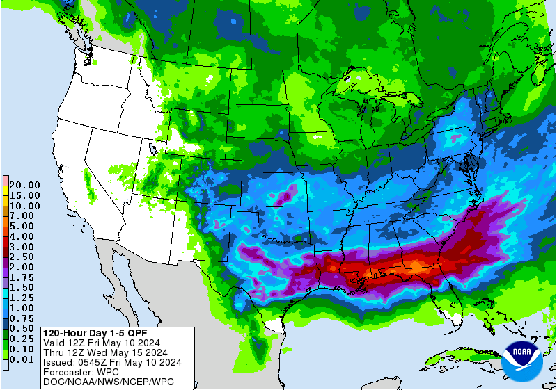
5 Day Rainfall 
Ha check out Canada..

p120i.gif (750×562)

Tropical moisture still on the move.

latest72hrs.gif (947×405)

Note how many areas could show development.


Not showing the cone today.
Weather is everywhere in the SE.
Nuff said.


An image I found online.
Before and after.
Pieced it together.
Chaser video and Google Maps.


Why people live there?
Paradise most days.


Beautiful.


A friend of mine in Augusta posted this today.
Her power is out.
She's barely posting.
She wanted to get this message out.


Well I'll add... down the road.

Thoughts and videos below.

Jose....You gonna loop around out there forever? Where you gonna go? Do you go from being a looper to an ocean spinner? Most of America is praying you take the easy way out and go out to sea. Time will tell. With long term loopers you just got to sit em out patiently and watch what upper level patterns evolve while they are doing loops in the Atlantic. Let me say this about that.........  way better Jose is looping out in the Atlantic than moving over South Florida while they are trying to clean up. The last thing you need is even a strong thunderstorm that slams parts of your home that were weakened from the Hurricane. Often that set up is like the straw that breaks the camel's back. My friend's house during Andrew held up pretty well on Miami Beach, but the East facing window broke weeks later after an extremely strong, typical... South Florida thunder storm. See that is the problem, we don't go back to a quiet weather pattern.

It's summertime in Florida even though they be selling Pumpkin Spice Lattes at Starbucks. Hot, humid and the only time the air moves is when a big thunderstorm is coming in. Cooler days are far away... think November. When Hurricane Wilma hit South Florida it was getting into late October when a few cool fronts blow through. Wilma caught one of those early cold fronts and after Wilma it was way cooler and more comfortable than after Andrew in late August. And, that set up that brought Wilma to South Florida may bring Ophelia, Phillipe or Rina later this year. Yes, I mean that and no that is NOT hype or dramatic hyperbole. That's life in the tropics during Hurricane Season. Kind of like how you feel up north in February when you just want the snow storms to end and the cold weather to go away. You just want to stop having to wear boots, coats and you just want to put on your flip flops and feel sunshine

Typical October Hurricane Track

260px-Wilma_2005_track.png (260×230)


And that's something I want to talk about here. Stop asking why people live in Miami or Naples or the Florida Keys. We are not stupid, we know who we are and how we like to live and are are actually quite smart. We figure the odds and know that once every few years (or every twenty if you get lucky) a hurricane blows through. You clean up and life goes on. And, often you get very lucky and don't see a Major Hurricane for fifty or sixty years; that's pretty much a lifetime of living in paradise. A few months of putting life back together is better than living 40 or 50 years in places that do not resonate with you. There are towns far from Oklahoma that have gotten bad tornadoes and the whole mid section of the country is prone to heavy floods in the Springtime. I had a friend when I lived in LA who grew up in Ohio with her family home by the river. She told me what life was like on the river and how often it came up over the banks and flooded their home. Being a tropical girl used to when the wind howls in September the idea of the river coming up and running into your house seemed crazy. She smiled and said "well the river does go down you know and then you clean up" and I'll add life goes on. I can't think of too many places in this great and beautiful nation that could not have some sort of natural disaster. So rather than bitch and complain about "crazy people that live down there by the water" reach into your pocket and know but for the grace of God that too could be you. Gas explosions that take out whole blocks, 100 hundred year flash floods in places like Ellicot City where I'm sure many there felt safer than living down on the coast. https://www.weather.gov/lwx/EllicottCityFlood2016

And everyone in Florida isn't rich or famous like the people you see on TV shows. We actually have quite a bit of simple, good folk who live in small towns and never get to Miami or Naples. They live down by the water, they fish and it's actually quite Southern. You don't get that vibe on South Beach but trust me it's about as Southern and Country as it gets. Places up the coast North of Tampa and NW of Orlando that live in rural towns. Remember that classic movie Doc Hollywood was filmed in Micanopy Florida. You might want to check it out sometimes, it's a beautiful place; actually quite artsy and picturesque. Sometimes the wind blows...

And Irma found some of those places you aren't hearing about in Southwest Florida. Yes it hit Marco Island and it grabbed the headlines. Try checking out places like Everglades City that's a paradise for people who like to get away from the cement jungle they feel Miami is and who like to fish and be close to nature. Everglades City isn't for everyone, but for those who love it ... it is everything they love.  Yes Jacksonville and Charleston get all the media, so I'm trying to remind you of the scope of this ongoing disaster known as the 2017 Atlantic Hurricane Season. It's not over but it should help the rest of you not yet affected to properly prepare and buy more than 1 pack of AA batteries for your radio and storing some extra gas or cash somewhere safe in case you need it.


This video is before Irma and this story is about what it was like there during Hurricane Irma. 


Irma made landfall above.
Around the red circle.
Another blog explains why...
...they be so different than the other Keys.


http://www.tampabay.com/news/weather/hurricanes/everglades-city-cut-off-by-flooding/2337032

I found this last night and it's a great over view of the Lower Keys where Hurricane Irma made landfall. It shows the actual Keys, maps of the Islands and lifestyle people buy into when they retire to a piece of paradise they can afford. Life there may sound pricey to some of you but it was one of the only affordable places to live down near Key West where people live in one room studios in old Conch homes not fixed up similar to how many live on a sailboat... meaning really simple keeping only what you need but enjoying the view and even those one room studios are a fortune. So many live down on some of the nearby Keys where life can be a mix of rugged frontier sort of life and a well built, beautiful home built to retire and live out your golden years in a place you always dreamed of living. Fisherman, service staff such as waitresses and chefs and school teachers don't live in Key West if they can't afford it and they commute up from places like Cudjoe or Ramrod Key. Note the videos and yes some of those places look like location shots for a movie based on a Carl Hiaasen novel.


I worry on how the school held up and note if you watched til the end the older kids go to Key West High School up the road. Then there's a video of Ramrod Key below.


Below is a video posted online from Cudjoe Key and it sure looks like Cudjoe to me.


No life in paradise isn't for everyone. But then life in Atlanta isn't for everyone and outside Atlanta today 3 people died in Georgia from falling pines crashing through their homes or Irma related accidents. Who knows how high the total will be by the time all of the missing are found. And, when I talk on a death toll I am talking even up in Sandy Springs, Georgia where people feel they are safe from hurricanes and heavy snow storms. And speaking of SANDY this season isn't over so those of you living up in Queens dreaming of what it must be like to live down in the Keys if only you had the money or the guts to pick up and relocate... Ophelia or Rina may find you later in the Hurricane Season.

We are all in this today. To steal a saying from my second or third home Key West we are "one human family" so reach into your pocket and whether you give a dollar at Belk when you buy those cute new winter boots or at Kroger just do it. All those dollars add up and if you have more then give more. Some of that money one day could come back to you as Kharma is like that. What you give at some point you get back but we don't do it wanting anything back we do it to be the change in the world we want to see..  to make a difference.

one-human-family.jpg (3172×983)

Red Cross is a great organization that is prepared to jump into action being well trained and seemingly everywhere when we need them. I'm associated with the Chabad movement that opened up 25 of their Chabad Centers across South Florida inviting people in their community without power to come, use whatever power they had and many made BBQs I'm guessing with meat they had stored in their freezers. I know there are many great organizations doing the same thing and if you know some Tweet them or put your links on Facebook. This is who I am so I know what my friends are doing to help others who are in need in the most organic way they can; sharing their power ( generator ) and telling people to come for coffee, charge their phones, talk and maybe have some BBQ.

This is not just a news story from my world, some of those people who operate these centers are my personal friends. 


So be it the Cajun Navy in Harvey or Chabad in South Florida or your own Catholic Church or a mission you know that is reliable and trustworthy when asked give whether it's a $1 at Kroger or $5 at Belk, just do it please.


I'll say this about fake news. Every time you see that video on Facebook that's been around for 10 years but now posted again everywhere that shows a gator walking through some place in Florida NOT after Irma but it is tagged as Irma put a quarter in a jar and give the money to UF Chabad the home of the Gator Nation for many. They are awesome. http://www.jewishgator.com/

43_400x400.jpg (400×400)


I'll update later today with more information on Jose. It's out there looping, let's not wake up a sleeping dog right now. Watch the coverage on TWC and give what you can and remember the Hurricane Season is not over but you can start preparing now if you have not already. As for Irma she has died out finally but her rain remains and her devastation is just being discovered. It's raining as I read this in Raleigh, a gray steady rain and I can see the tops of pine trees swaying a bit. See in Carolina I get tropical weather and an occasionally snow shows up. The rain formed in Africa and moved across the Atlantic Ocean, though the Caribbean and up through Florida to rain on my grass this morning. Kind of amazing and why we are often so amazed at hurricanes spinning across the satellite loops and more often than not they swim out to sea. Irma did not and now we clean up. My kids I believe are headed back to rejoin the rest of the family in South Florida today. My son-in-law just arrived with many first responders who drove down in a convoy with Fema trucks. From the Cajun Nation to my Satmar son-in-law Yoely married to his Chabad wife we should all be one human nation doing what we can to help each other through tragedy. 

1200px-Hatzalah.jpg (1200×903)


Besos BobbiStorm
@bobbistorm on Twitter


Labels: , , , , , , , , , , , ,

Sunday, September 10, 2017

UPDATED 10 PM IRMA LANDFALL ..Right Sided IRMA. West side Drier ... Cone Doesn't Tell the Story....MARCO ISLAND, EVERGLADES CITY .. NAPLES ... MOVING N TMOBILE DOWN IN WEST BROWARD..LOOK WHERE IT MADE LANDFALL..Just W of Hurricane Donna.. Same Day in 1960.. Moving NORTH...NORTH not NNW.. Made the turn sooner rather than later.. New cone at 5 PM or 11 PM?


Dry side on the West.
Strongest weather to the EAST
Right sided Irma now.

sat_wv_east_loop-12.gif (640×512)

So let me explain something. For now let's trash the cone. IRMA made landfall... the high in the GOM that is pushing down on her left side is drying out the storm. Dry LEFT SIDE... Tampa not gonna get much... exciting but not the big landfall everyone feared. To the N and NE far in advance of Irma the energy transferred to the frontal boundary that was there and it is raining from Irma up through but not to be limited to Jax, St. Augustine, Melbourne, SSI GA... Savannah and into Charleston. To the NW where their CONE shows Irma moving is DRY AIR. Eventually remnants of the circulation will move towards Atlanta but it's not gonna be what NE FL is getting now while IRMA is over the central part of the state. 


In motion.

rb-animated.gif (720×480)

Another view


The cone is great most of the time.
But at this point it's misleading.
It leads ppl in SC down the wrong road.
Ppl say going to Tennessee.
And it may in some way.
Atlanta will get some.
BUT NOW... 
Wxr moving NE fast.
FAR AWAY FROM IRMA

More like an extratropical storm now.
Odd but true
And look at Jose.

It's a problem.

hifloat5_None_anim.gif (768×496)

DO NOT LOOK AT THE CONE NOW
Watch IRMA.
Hasn't hit Tampa yet..
Yet weather East of Jax.

Will update at 11 PM.
Keep reading please.
Tired, annoyed and thankful.
Thankful it hit Cuba.
Thankful Miami didn't get a Cat 5.
Very upset about Marco Island.
Tomorrow video from Keys will be tragic.

Saying this short and getting off. The coverage from Harvey was NOT Hurricane Damage but flooding associated with Harvey. To cover the sexy city of Houston... famous in movies and TV shows they covered the immense flooding in the Bayou City... but the HURRICANE DAMAGE was down in Rockport Texas totally ignored.  Katrina ...same thing. Media totally ignored Waveland that was trashed and showed the levee failure. Yes.. it was news, it was tragic and compelling. Tomorrow when you wake up and see video from Lower Florida Keys, Key West, Miami, Marco Island you will see HURRICANE DAMAGE. All the damage from Hurricane and storm surge. You will see what a Major Hurricane can do at landfall and there may be more hurricanes to come this year. I would not be surprised to see another Major Hurricane. In fact I'll be surprised if we don't have one. Speaking of hurricanes ....Oh ......look at Jose...and one of the best looking waves I've seen in a long time coming off of Africa. The Hurricane Season is not over. If you live in a part of the country that still have power and has not been hit. Go shopping and buy LOTS of batteries and flash lights and battery operated radios and crayons for the kids. Trust me..

Jose in the Bahamas?


New Wave off of Africa.
Not off yet.


So a little tired of hearing how the storm is moving along the cone yadi yadi however you say that. Watch the storm.

Iconic Building in Miami.
Brickell.


That moment u realize ..
..u missed the Panthers Game.
They won.. I missed it.


Went out for a bit.
Dinner and a drink.
With the Miami kids up here.
While talking to the other kids online.

Been exhausting day.

Very guazy cloud cover.
Bit breezy. 
Cool.


As I said earlier.
Storm merged with the front.
Energy spread out.
Far from the eye ....
... strong weather.

From Miami to St. Augustine.
While the eye was near Naples.

Just such a big circulation


You can't make out the State of Florida.


The water is going to come back fast.


Not much to say and been drinking white wine so don't want to go long and whine about how stupid this all is and how annoying it's been listening for days to young meteorologists some of which have NEVER BEEN IN HURRICANES explain models and tracks and which model wins this one. They don't get it. Unless you have been in one or far from one you are clueless it's NOT ACADEMIC. It's not a video game it is REAL at ground level. SPOILER ALERT small places exist in America so hurricanes don't just hit Miami or Tampa or NY or Houston but small towns. Katrina did NOT hit New Orleans it slammed WAVELAND MS... Naples is getting slammed. But people across the whole state are getting slammed with rain, flooding, tornadoes and high gusts that are way above the sustained winds they were forecast. No one gets that... you get sustained winds of 65 MPH but you get a band come through with gusts ... long gusts of 100 MPH.  Sustained winds in Naples of 95 MPH at the airport currently. The eye  ... or decayed center may go up NW into Georgia and Tennessee but the WEATHER is feeding into what was the front and it's moving NE .. look at weather East of Daytona. And that will continue up the coast into Georgia, Sea Islands, SC ... inland GA SC will be a LONG TIME before Floridians can drive home as debris will be across the highways and much will need to be cleaned up BEFORE the world's longest traffic jam will occur in a week or so. 

I'll give you a five day cone for when Floridians will be allowed to begin to drive home across North Florida... Georgia... South Carolina... good luck.

avn_lalo-animated.gif (720×480)

Look at the REDS by the Cape.


IRMA.
IN ALL HER GLORY
EXTREME WEATHER FAR TO NE
SW
NOT just about the EYE

hifloat5_None_anim.gif (768×496)


Model madness
if you really think a hurricane
is along a LINE.
Across the whole state now.


Landfall Marco Island
As I said here earlier.


Be clear.
Small homes.
Mansions.
All built to be ON WATERFRONT LOTS


Again posting this.
This is where Irma made landfall.
Just cruel. Really cruel storm.


Will see how this worked out.


 Image from Miami.
Under water from FRINGE of a Hurricane.
Imagine if this was DIRECT HIT.


Dismal Key.
Good name for landfall maybe.


In a matter of minutes water rising 
Naples Marco Island
LIFE THREATENING
FROM NHC NWS
10 to 15 FT above ground level.


Coming in between Naples and Everglades City.

http://wsvn.com/on-air-live-stream/
Miami NEWS live


2 PM...

hifloat5_None_anim.gif (768×496)


Wobbling wildly
NWS KEY WEST
FLOODING AND TIDAL SURGE INFO


2:30 PM
Updates
Pictures thoughts.

Area below Marco Island.
Built so everyone has a waterfront lot.
Neil Frank said it was dangerous.
Some day a hurricane will hit.


Neil Frank knew Hurricanes
Another view below...


Low lying homes. 
Going to take a beating.

A comment from someone I respect.
Thanks.
As I said N movement.
Energizes front.
Jet venting.
Taking E side of the NHC Cone.


Note where the weather goes.
NOT the cone.
The weather.
N up to GA SC NC


Tired of hearing models
Watch IRMA at this point.
Watch the atmosphere on WV Loop.

sat_wv_east_loop-12.gif (640×512)

Watch the dry line.
Irma one with the front.
Taking over.
May turn NNW
But it's going N now.

Note below Raleigh NWS
They do THEIR weather.
I say it ALL the time.
YOUR NWS has YOUR back.
NHC is great...
Follow NWS in your city.
They are on Facebook.
They are on Twitter.
I know .. no cat pics.
BUT THEY HAVE YOUR BACK


Note wide view.
Front. Irma. Jose.
Maybe Lee.


Close up.
Moving N... Irma not.
Irma thinks:
"Fine I'll go to NC u take FL"


Models.
Again taking right side for now.


Note devil in details.
I googled Naples to Everglades City.
I didn't mean Naples Italy
(embarrassing)


That's better.


IRMA moving N..
Everglades City
Naples.
Maybe just right of Naples.
Marco Island.
All in immediate path.
Then we worry on Tampa
And Orlando .. Ocala


Miami River :(
FRINGE EFFECT
NOT A DIRECT HIT
Can you imagine if Irma hit here?
Yeah... think on that a bit.


Why history repeats.
Nothing new under the sun..
or under clouds in September


Friends sidewalk on Miami Beach.
Trees going down..


Irma taking right side of NHC cone NOW


View from friends house in Miami Beach.


 I'll update at 2 PM

Be clear damage in Miami is the luck or the unlock of the draw. If your house was well maintained the ceiling roof may be good. If not... or if something hit it in a large gust... bad. I have friends with water leaking, sheds blowing down the street and massive ficus trees (think Tarzan) lying on their homes in Miami Dade County. If a tornado hit your block or a cell moving fast with rotation you may be in worse shape than a mile away. And this is far from over. A strong band in Irma's tail will set up and train rain over Miami for a day or two. Trust me on this unless they get really lucky. Models show that now. Understand Marco Island may FINALLY be tested and the whole area from Naples to Tampa may be as well. It could go E of there and come in further South closer to Everglades City.. a city on the edge of the Everglades. Miami is mostly without power, TMOBILE down in areas so... oh and cranes did fall over as predicted.

Lastly for the next hurricane PLEASE by HUGE packs of batteries. You spend more on Starbucks in a week........buy them. Store them. We are not even at peak of 2017 Hurricane Season. I've had ppl tell me they had batteries but didn't buy a lot and radio not working. Why not? It's the cheapest most important thing you can buy. I guess it's hard to remember how battery operated radios eat energy. 

Shop accordingly for the rest of the season. Update after 2 PM


Please read carefully.
Cone below.
My thoughts as well at bottom.
Takes the right side of the cone in short term.
It's going N now at 9 MPH.
This is not rocket science.
You don't need the EURO or GFS to see that.


WV LOOP

sat_wv_east_loop-12.gif (640×512)

Irma at the base of the front.
That was stalled out.
Irma will energize that front.
Weather will move up N NNE NE 
They evacuated parts of GA for a reason.
Savannah - Tybee Island

Close up


This is ME not the NHC
I said last night lower keys.
I said when I woke up Cudjoe.
I'm telling you....
Irma is moving N..
From N it curves along N side of Trof.
It could go over the Lake.
Naples and Tampa will get some.
How much?
 Orlando gets what?
Naples could get the eye.
But could come in S of Naples.
Does it bend NNE or stay N
Who gets the eye?

Moves over warm water the whole way.
Florida Bay.
Everglades.
Can intensify..or stay the same.


I'm not saying Atlanta won't have a mess.
Stop focusing on metro areas.
This is a ground level drama.
Fluid in real time.

Water over Florida Bay..
..too hot to swim in for ppl from up north.
WARM HOT
FUEL for IRMA
It's not weakening.
As it goes over the Everglades.
Intensifies.
Brown ocean or water effect.

History repeats.
Always in some small different way.


I wrote this DAYS ago.
This is why I show analog storms.


Same Day.
Same place... just to the West.
1960 Donna
2017 Irma

avn_lalo-animated.gif (720×480)

Small islands on SW coast.
Thousand Islands...
Getting slammed.

TenThousandIslMap.jpg (800×625)

Big Pine Key.
Note where the hoes are..
...at ground level.
I have friends who live there.
They are not there now but they live there.


Landfall in the Florida Keys; so many small Keys that the eye went over, places I love dearly. So hard to write and think and speaking to kids back home as well as kids who are far from home and everyone watching Irma. Understand these are some of the lowest keys and part of the Overseas Highway in some areas are FILL built through mangroves to connect Marathon with Key West. Marathon is a big Key think grocery stories like Publix and Kmart but small keys like Cudjoe and Big Coppit are not really that big. And the parts of the Overseas Highway that traverse that area are fill...and water has been over them now for hours as Irma moved slowly and parts of those road beds may need to be repaired before any traffic can roll down to Key West.

In the old days before the bridge was there they used ferries to get from the bigger keys to the next bigger keys. Then they put down fill and built a road bed (AFTER THE TRAIN was blown out to sea in 1935) and so now we have a highway. Views from that beautiful road are shown below. Note some houses are built high up, others low to the ground and those low to the ground will be at the least inundated or carried out to sea.


Going South...
See the homes at sea level?


Close up..


Look carefully at this street.
See the house built up high?
Now look at the house on the ground.
That house may be out to sea.
Or destroyed.

This is the story you are NOT seeing online.


I don't want to hear now about Tampa or Naples.
Hunker down. 
Be warned the storm may come to you.
 I believe its taking the RIGHT side of cone.
It's going N now.
This is not rocket science.

Stay tuned updating in real time.
Talking to friends on Miami Beach.
Trees down .. power out.
My kids have power but Tmobile went down.

Note to ppl here.
In the future..
Buy a burner Virgin Mobile Phone.
Activate it before the storm.
That way you have an extra phone service.

Hurricane Donna.
Same day. Same basic landfall.
Drop to the West.. 
That's why we study history.


Besos BobbbiStorm
@bobbistorm on Twitter

ft_lalo-animated.gif (720×480)


Labels: , , , , , , , ,