A writer and a tropical muse. A funky Lubavitcher who enjoys watching the weather, hurricanes, listening to music while enjoying life with a sense of humor and trying to make sense of it all!
Thursday, May 16, 2019
EPAC Firing UP ON TIME. Atlantic Hurricane Season Begins JUNE 1st. Hurricane Supplies Tax Break... Use it or Lose it! Do You Know How Long It Takes to Become a Cat 5 Hurricane? Don't Blink!
Touching base here on the possibility of development in the EPAC. It's worth noting chances are currently low but the persistent presence of tropical moisture congregating ups the ante for tropical development.
I've mentioned this over the last several days and pointed out the presence of possibilities and the official season in that region began yesterday so that's kind of normal all in all. Conditions are not perfect but in place to pay attention and see what if anything evolves.
Speaking of paying attention that goes for the Atlantic as well.
Development in late May around June 1st happens often.
Usually it's weak or subtropical but it does happen.
It happens often at the base of an old decaying trough.
We have such a trough currently in place.
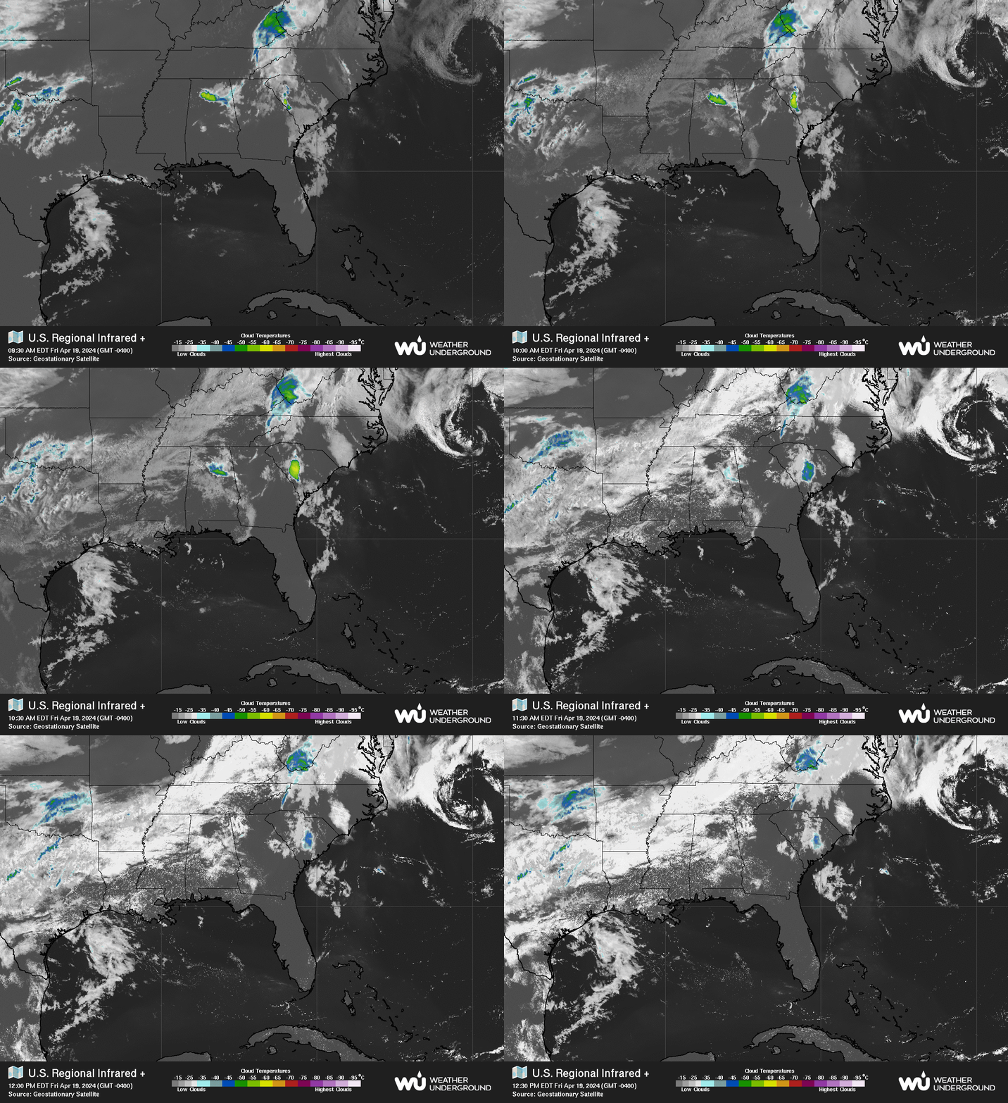
The set up remains and is delivering rain to South Florida.
I keep posting this loop for a reason.
It's the season when daily monsoonal moisture flares up.
But this is more than "just afternoon rainstorms" in Miami.
Note the morning warning posts.
This is not common in May for early morning rain.
Late afternoon rain from the Everglades happens.
Early morning rain happens because there is a trough.
The reason for the early rainy season....
Not expecting anything huge to form.
But the possibility is there the longer this persists.
The good news is this is a great time to prepare ....
Hurricane Season officially begins June 1st.
There is a tax holiday on hurricane supplies coming.
Take advantage of it ... save money and be prepared.
"The sales tax holiday for hurricane supplies will run from May 31 to June 6 on items such as batteries, generators, weather radios and fuel cans."
Read the article in the link above and find out the details. Make a list for what you need as everyone has their own unique priorities when hurricane season is upon us and that depends on where you live, your health issues, whether you have pets or small children or teenagers who may try to party somewhere. Trust me this happens with teenagers, you may want to send them to Aunt Louise to visit if you are worried on that. Just saying.....
Tidbit of the day....
This fact has been all over Twitter recently and it's very true. I say it over and over in the blog yet it goes under the radar as most sayings go better with a good graphic. Worry more on years where storms are forecast to develop close in rather than waves rolling off of Africa so neatly formed that they develop immediately and become Fish Storms. Katrina, Andrew, the Labor Day Hurricane. Many form very close in to Florida and traveled fast and developed intensely over the Gulf of Mexico. And, it's worth nothing that all of the Category 5 Hurricanes that did make landfall developed close in and went from tropical storm status to Category 5 in 3 days time. So don't get caught with your pants down thinking nothing is gonna happen because you read some article somewhere and had a false sense of security because all the hurricanes were dying out over the Atlantic or going somewhere else and suddenly you wake up and find out that the tropical storm off the Florida or Louisiana coast is expected to be a Major Hurricane and they hoisted watches and warnings at 5 AM and by the time you got to Publix all the toilet paper you like was gone, gone, gone.
Don't say I didn't warn ya.....
Again look at the proximity of the storms to Florida and the Yucatan that developed into Category 5 Hurricanes and made landfall. If that doesn't make you start making lists and checking them twice nothing will .... until it's too late and your favorite toilet paper and snacks are gone, gone, gone.
For those of us who have been there....
...we do not forget.
Looks a lot like after Michael looked last year...
Invest 94L in the Caribbean. Circle in the Carib 40% Orange Today. Hurricane Hazel Anniversary. Cat 4 Hurricane in October in the Carolinas All The Way Into Maine. Hurricane Matthew and The Johnston Flood Discussion. Reminder to Give Charity as $$$ is Needed in Hard Hit Areas. Thank You.
Yes there is something in the Caribbean again.
It's name today is Invest 94L.
It's being studied for possible formation.
Some models try to take it North I'm not gonna lie.
But many take it into the Pacific...
The tropics today show us an orange for Fall 40% circle in the Caribbean. We spoke about this last week that it was very possible after Hurricane Michael was long gone low pressure would try to form in what is a climo favored area in the SW Caribbean in October. There is no voodoo here going on, it's where the tropics are usually active in October and the pattern this year makes it possible for another storm to form. It's also worth noting ironically the MDR is finally warming up and there are several healthy tropical waves moving Westbound towards the Caribbean as I type this post. This year is unique in that the EPAC is still going strong in October so perhaps it will go there vs up into the Gulf of Mexico. Time will tell. Just watching today. And, the warm water in the MDR and along the East Coast makes it a priority to keep watching the tropics into November this year.
Note how Dabuh tracks the waves.
He explains the set up that usually develops storms there.
You don't need to speak Spanish to understand the one below.
They are not Invests they are waves and they are numbered.
And they are watched and studied.
Fronts often stall out off the East coast so we watch there too.
Cranky explains with great maps.
Snow and storms.
October it has it all.
Sadly it also has Santana Winds and Fires as well.
But this is about the tropics today.
I lived in California a long time...
..October always makes me remember Santana Winds.
Mike's traveling back to Florida he is seeing up close and personal..
...the damage from Hurricane Michael.
Knowing him as I do he will talk on this in depth.
It's humbling to see that sort of damage.
Now for some Hurricane History as today is a huge milestone in Hurricane History as it's the anniversary the strongest hurricanes to slam into the Carolinas and in the middle of October yet. Maybe Global Warming started back decades ago or maybe we don't have historic records of hurricanes that made landfall in the Carolinas in October during the Crusades or the Roman Empire or the days when the Vikings were coming to America before the English ever came here. History is the long, long, long term study of life on our planet and when it comes to weather history other than odd scribbles we can't totally decipher on cave walls in Spain we don't really have reliable information before the middle of the 1800s. Seafaring explorers and pirates kept some records and Columbus wrote about an out of season Hurricane and he knew the difference between a Gale in the Winter and a Cyclonic system; he once used knowledge of an soon to happen eclipse to get out of being a victim in the Caribbean. Old time seafaring people knew more than when we give them credit for without satellite imagery, the ever maligned GFS or highly touted EURO and they knew storms.
They say history repeats and in truth it repeats often. Matthew was like the second coming of Hazel except it was kinder and pulled away from the coast rather than plowing far inland. It also made landfall as a shadow of it's former self intensity wise but it still packed a huge punch.
Compare the track to Matthew below.
Hard to believe two storms could have such similar tracks.
But then in 1954 and 1955 six storms had similar tracks.
1954 and 1955 were horrific, legendary years in Hurricane History in modern times along the East Coast of North America. Six hurricanes in two years took aim at OBX that juts out into the Atlantic seeming to scream down to the West Indies "Hit me with your best shot, fire away" and Mother Nature did on a regular basis.... but six in two years? Those charts above look similar but they are two different years that aimed cyclonic fury at the Carolinas and the Eastern seaboard. I'm guessing the water was unusually warm along the Eastern Seaboard as it has been this year to maintain that sort of energy that far North.
Actually Hurricane Hazel caught that front and went straight to Canada.
The pictures below are from Wilson, NC
Note how far inland Wilson is....
Wilson is a charming town that was once one of the capitals of tobacco country; the County Seat and it has grand old buildings that hint at it's history back in the day. I could show you pictures from Raleigh but I like this pictures, the pictures from Raleigh look the same. I spent some time at the Wilson Public Library talking to the man in charge of the history room and he showed me pictures and told me stories and he made it clear that in "our lifetime" no hurricane did what Hurricane Hazel did to towns far inland. Yes, Hugo hit Charlotte and yes Fran hit Raleigh but according to him no hurricane round these parts did the damage or had the fury far inland as Hazel did in 1954.
Whole books shown above have been written just about Hurricane Hazel that raced North to catch a cold front in Mid October the same way Hurricane Michael did early this month and Hazel made landfall as a Category 4 much further North than Michael delivering hurricane force winds far into the interior part of North Carolina and parts of the Eastern Seaboard. A good blog post from Wilson explaining Hazel in their own words.
Looking at the 1954 hurricane season again you will notice one thing about it, a lack of deep MDR action or CV Hurricanes. They seem to form further West and thrive further North than most years. I want to make this clear I am not denying concerns on Global Warming but it's not a basket you can toss everything into or something to blame when history is just repeating. In general we have barely had strong hurricanes over the last decade or two in comparison to the 1920s, 1940s through the 1960s. The last two years have been a throwback to the old days for whatever reason, but if you are going to blame Global Warming you have to explain why we had a lack of landfalling strong hurricanes for a long while before the tropics became active again suddenly and you can't just blame it on El Nino as Andrew and Betsy were El Nino years. I'm sure there's a reason, there is always a reason.
Another example is the back to back Flash Flood in Endicott City. When it comes to Endicott City and the recent flash flooding they have had I wonder how much development of the area has made the flash flooding worse. Easy to blame that on Global Warming but in truth it has become a popular area outside Baltimore and the construction in that area could seriously have made a bad situation worse. It's an example where "MAN" has built up areas beyond the ability the topography has to maintain the flow of water in areas where it's probable if they knew then what they knew now they would not have built it there but somewhere else nearby. In those days cities needed a river and you built near the river and when it flooded, you buried the dead, rebuilt and prayed it wouldn't flood again. We know more now and yet we keep building in areas not meant to maintain such growth.
So.......... know......... hurricanes have always happened in October even Category four hurricanes and flash floods have always happened when cities were built near the river in narrow canyons where the ground below could not absorb any of the water. Recently I learned something I never knew about a historic flood in America. This is a blog worth reading and again man (I use the word collectively) changed nature for their own needs and greed and the outcome was horrific using the Michael adjective of the month. Some of the world's wealthiest men were involved with a hunting and fishing club and they made adjustments to a nearby dam and that sadly led to one of the Nation's worst "natural disasters" that killed over 2,200 people.
"The club did engage in periodic maintenance of the dam, but made some harmful modifications to it. They installed fish screens across the spillway to keep the expensive game fish from escaping, which had the unfortunate effect of capturing debris and keeping the spillway from draining the lake’s overflow. They also lowered the dam by a few feet in order to make it possible for two carriages to pass at the same time, so the dam was only about four feet higher than the spillway. The club never reinstalled the drainage pipes so that the reservoir could be drained." https://www.jaha.org/attractions/johnstown-flood-museum/flood-history/the-club-and-the-dam/
"The dam broke after several days of extremely heavy rainfall, releasing 14.55 million cubic meters of water.[4] With a volumetric flow rate that temporarily equaled the average flow rate of the Mississippi River,[5] 2,209 people,[6] according to one account, lost their lives, and the flood accounted for $17 million of damage (about $463 million in 2017 dollars[3]).
My last comment here is to give money to the Red Cross www.redcross.org and the reason why is simple. They know from experience what people there need and they have the means to get it into the areas to help the most people possible. There are many good charities. I have given Chabad of Tallahassee charity money for years as I know them as some of my children have lived in the area and I know their work well. They are helping people there survive the aftermath of Michael in the Panhandle. https://www.chabadtallahassee.com/
Please read the story and though it's run by a Jewish group they help "people" in need whenever they can as do most charities who do awesome work. The act of charity is one of the biggest mitzvos (good deeds) you can do and if you have the ability to volunteer and work with a group, a Church or the Red Cross more power to you as it takes a village to rebuild our villages sometimes.
If you know a good charity or organization that is raising money for people in that area then I suggest you research them well to make sure they have the ability and the network to get the job done and if so please donate and possibly volunteer to help them yourselves. So much needs to be done and it will need to be done for months... not just weeks as it will take a long time for the region to rebuild. Not only is it compelling to see convoys of power trucks moving into the area, it's also humbling and compelling to see people in vans bringing baby goods such as diapers or pet food into a stricken area from far away. I saw that after Irma... as we drove South back to Miami next to several vans filled with boxes of diapers on their way to help from New England. God Bless Them.
The Hurricane City is not over and sometimes patterns repeat and it is possible areas that were affected so far could be impacted again. I am not saying it will happen but models show the possibility and the pattern itself lends itself to a repetitive pattern in the Gulf of Mexico and along the East Coast be it a hurricane or a hybrid sort of storm coming together with a front. With fronts on the move concerns are still there but they evole into other set ups that bring trouble both tropical and weather wise.
The real "Perfect Storm" was Hurricane Grace joining together with other weather features to turn into what really was the "Perfect Storm" not just a book and a movie. Watch the video from TWC on how Jim Cantore and the legendary much missed John Hope covered this historic, complex storm.
UPDATED Midnight! Hurricane Michael Stronger. Moving Faster.. What Kind of Hurricane Will It Be? Cat 1? Cat 2? Cat 3? NHC SAYS CAT 3 - MAJOR HURRICANE EXPECTED -FAST MOVING Hurricane Becomes FAST Moving Tropical Storm. Stay on Top of YOUR LOCAL EXPERTS. Wind Not Just Rain is the Problem With Michael.
11 PM.
Why you still up? I know... intensifying hurricane.
Forecast to be Cat 3 Major Cane.
Cone pretty much the same.
Wiggles often by smallest degrees.
NHC Discussion below.
Extremely honest and well written.
"defies traditional logic"
Intensifying under shear....
There it is below.
Eye popping out.
Another view.
Once past the tip of the Yucatan.
This happens ....
Land interaction diminishes.
We see what it's got there.
Still close to land.
Shear there...
Hasn't hit the warmer water yet either.
Expected to be 120 MPH in 36 Hours.
Expected to be 100 MPH tomorrow.
Excellent graphic below.
Estimated rain totals as of tonight.
Florida through the Carolinas.
Again please use this feature from the NHC if you need.
Just use it as you would a zoom map. You can find exactly where you are in relation to the watches and warnings. The specifics pop up and give you incredibly accurate information.
Satellite imagery below showing the CDO... eye forming, structure and the cone. Be safe.
Know the cone will wiggle back a bit.
Model runs tomorrow will have good data.
So far the models have been in agreement.
Again the cone is for WIND.
Cone is for EYE.
Weather impacts are outside the cone.
Storm surge will be everywhere far from the eye.
Flooding, tornadoes and power outages.
Plan accordingly.
If you have not read this earlier...
Some good model discussion.
Good information on places in the path of Michael.
She wanted to make sure Hurricane Season was over.
A Florida girl knows this is a thing....
Actually she's a FSU fan.
Those beaches are Tallahassee's beaches.
With the lighthouse as the backdrop.
On the beach at sunset.
Me and my girls.
My daughter Rivky on the left.
My daughter-in-law Kristin on the right.
Judah my Grandson who LOVES Hurricanes...
"cause who wouldn't??"
With his Step Mother.
It's a beautiful beach.
They all are up there.
But really I wanted to say I got a real feel ...
...for the Panhandle beaches.
My grandma grew up going to those beaches.
Her older sister lived in Quincy Florida...
....they'd go down to the beaches to visit.
The eye may go left of St. George Island.
But the storm surge should pile in there good.
The eye could go on either side.
or.....hit it dead on.
Time will tell.
Many of the structures are built up high..
They are used to storm surge there.
Long causeway...
Narrow Beach
Beach homes.
Beach homes up on stilts.
Panama City is a bigger town.
More populated.
St. George Island like Emerald Isle in NC
Or some beach in Texas.
Destin...
On a sunny day WOW.
Paradise found....
sometimes hurricanes find it too.
Today if you Google Destin, FL
Google tells you there is a Hurricane Warning.
What a world we live in.
100 years ago no one knew they were coming...
A nice video.
It could be any beach up there...
Oh...I'm in Carolina.
It's a beach down there.
:)
Miami brain.
Do what you got to do and prepare.
Prepare along the coast.
Prepare inland for wind damage, power outages.
Prepare in Georgia and Carolinas ...
Strong winds will bring trees down.
I meant to update earlier.
I wasn't feeling well.
I'm feeling better now.
Hurricane Warnings.
Major Hurricane on the way...
Be Hurricane Strong.
Besos BobbiStorm
@bobbistorm on Twitter
& & &
Cuba is now dealing with this Hurricane.
East Tip of Cuba moving towards Florida Keys.
Important to remember it is right sided.
Note it has a tail forming.
But the tail is right heavy.
Some of the weather to the SW of the center is strong.
Let it lift up into the GOM ....
...it's still wrapping up.
And the whole mass of weather is moving N.....
I have nothing to add as it's a watch and wait set up but in this case we are watching and waiting to see how well Hurricane Michael wraps up and if it properly aligns and is well stacked then watch out. Major Hurricane status is on the table and the NHC put it there not me. The front is still there. Shear is there but it seems to ignore the shear and does it's thing much the way Florence did several times in it's history. Shear is a killer, yet sometimes storms seem to learn how to work around it. The moisture is already being pulled North across Florida and into Georgia. Light misty clouds are moving into the Carolinas far ahead of the storm. And the water is rising along the coast in many cities far from the storm and not directly in the cone. Speaking of the cone. I have a question.
Hurricane Watches were OUT Along the N FL coast.
Compare N contrast how far S the TS watches warnings go.
All the way down to Anna Maria Island near Tampa Bay.
New cone will be at the top after 11 AM.
Leaving this here so you can...
Compare and contrast.
To quote a song...
"The moment I wake up"
Ends with ...
I say a little prayer people pay attention.
Okay not same lyrics but you get the idea.
Mike does get the word out and I love that.
My concern here is a fast moving hurricane that could become a Major Hurricane before landfall but more so is moving so fast that it stays a Tropical Storm way inland over a large region as it's cruising fast enough that it could audition for NASCAR if you believe some of the models. And one day it can be a strong Cat 1 and less than 24 hours it's knocking at landfall at Major Hurricane strength and people start explaining why they didn't evacuate or prepare. In truth weather is fluid, models make predictions but they respond to changes in the hurricane at every model run and then it's up to the NHC to decide when or if they will adjust the track. So it's important to pay attention and more so pay attention to your local weather people. To put it simply they have your back, the TWC tries to cover the general area and yet your local weather people know your area and it's main concerns. Mike's Spaghetti Model's Lives Updates on Facebook are a great place to go also and note currently over 6,000 people are watching Live as he goes over a wide variety of valuable information. It's worth noting he actually goes back and reads through the comments so he get's a good feeling for what people want to know.
And as Mike said just now it blows him away that people are asking for basic information from the Panhandle from Florida because if he lived there he would already be "freaking out" and that is the beauty of Mike he is honest with his thoughts, emotions and always directs people to the NHC for the best information. October is prime time in Florida for hurricane season and yet he is right people have this attitude that after you get one big Major Hurricane on the East Coast and school starts and it's officially Fall they get a feeling "hurricane season is over" and it's NOT. In fact Florida gets affected most in October, it gets threatened all season long but you get something forming down in the Caribbean as we have been predicting it moves up into the Gulf of Mexico and in October the fronts start to move and dip and they connect and it's the real deal.
Example of "local people" who know your area best other than the NWS office are shown below:
In Raleigh Spectrum News has a local news station.
They show the weather EVERY TEN MINUTES.
They go live for breaking weather events.
You can't get better than that.
We had Spectrum....
... we switched to ATT.
I was annoyed about losing the weather updates.
.... it but figured it's worth a try.
We switched back fast.
Now I take those invites from ATT...
...and tear them up into itsy bitsy pieces.
Really.
The graph above shows the concerns for winds.
Everyone is showing the concern for rain.
They did too but few are talking about wind.
In Miami the big palm trees bend in the hurricane wind, everyone knows that. We do have decorative trees that are shredded in the wind, but they are more like ornamental bushes vs large, huge trees. From around Tampa Bay North up through Tallahassee and Jacksonville there are more and more huge oak trees and tall pines and neither pines nor oaks sway in the tropical breeze; they break, snap and come booming down onto homes or next to homes. As Michael is expected to stay at Tropical Storm Strength the whole way across the SE on it's rush towards the Atlantic Ocean moving possibly 25 mph or faster forward speed you will see trees come down, power goes and and it may be very locally as one area gets stronger wind and gusts or isolated tornadoes. This could happen to you if you live near pines, oaks or poplar trees that reach high up into the sky and come slamming, booming down fast in even relatively weak wind but steady wind. Especially with trees that were shaken up by Florence and aren't in the healthiest condition.
Nuff Said.
Chick in the Sandhills knows weather in this area well.
Every area has someone who knows the area well.
Listen to them, pay attention.
Don't listen to rumors.
He's talking on the rain.
If all goes as planned....
The rain is there but it's like:
"throwing a bucket of water out of the window of a moving car"
The wind could be the real surprise.
A good App to put on your phone is shown below.
They update fast and keep you very informed.
Cantore on air and on Twitter is "there'
He does a great job of communicating.
Despite the strong shear....
Michael is there.
You have to worry and be alert on that type of storm.
Shear would have killed off other storms.
The fact that it did not shows it's tenacity.
Recon found strong winds and low pressure.
Note what Levi Cowan said below.
The CORE of this storm needs some work still.
Again as it moves away from the Yucatan.
Up into the GOM...
...it will find it's groove.
Could that groove be a Cat 2 or Cat 3?
Time will tell.
Keep watching.
Timing is everything and uncertain.
The track moves back and forth a bit.
Each swing gets closer together.
Tomorrow the cone will be more narrow.
Watches and warnings from NWS are expanding.
And those models....
There they are...
North....
Then a bend.
Will the bend take it to the Big Bend of Florida?
Possibly.
Maybe further to the West...
...but the weather SLAMS into the Big Bend.
Storm surge would be strong.
Because it's N of Tampa it pulls water into Tampa Bay.
Tampa Bay will be far away....
...but as the Center cruises N and makes landfall.
Storm surge is an issue all the way South to Tampa Bay.
Models flirting with Major Hurricane.
Stay tuned.
Updating all day with new information at the top.
I posted a lot of online information today.
I will go longer on discussion and my thoughts later.
So stay tuned, check back often and ....
...check with your local authorities.
NWS.
Local TV Channels.
Local Wxr Ppl on Twitter.
Or whatever social media you use.
Do NOT go by Aunt Martha on Facebook...
..who is repeating rumors.
Unless Aunt Martha knows meteorology.
Stick with the authorities.
This is the NHC estimate of earliest possible dangers.
Winds mostly but you get the idea.
Are you in THIS CONE?
If so read part 2 of the my bottom line below.
Oh flirts with Long Island and NYC.
NJ
DC.
Some uncertainty down the road.
Yet it will be moving fastest at that point.
My bottom line again is two part...
1. Landfall and storm surge. Where and how strong.
2. As it moves inland maintaining TS winds due to it's fast forward speed.
The first concern is immediate and in your face over a specific area the NHC warns for...
The second concern is over a huge large area affecting many people told to pay attention to the NWS.
This is why the NHC has taken to linking at the top of their page to the local NWS in the cone.
Again weather happens far from the cone. Raleigh was not in the cone when that Pine Tree and all it's pine cones came slamming down inches from the house.
Location: Miami, Raleigh, Crown Heights, Florida, United States
Weather Historian. Studied meteorology and geography at FIU. Been quoted in Wall Street Journal, Washington Post & everywhere else... Lecturer, stormchaser, writer, dancer. If it's tropical it's topical ... covering the weather & musing on life. Follow me on Twitter @ https://twitter.com/#!/BobbiStorm