A writer and a tropical muse. A funky Lubavitcher who enjoys watching the weather, hurricanes, listening to music while enjoying life with a sense of humor and trying to make sense of it all!
Monday, September 03, 2018
UPDATED 11 PM Gordon 60 MPH -- Florence 70 MPH ... Invest 92L Orange Area in Atlantic Could Become Helene. Hurricane Warnings UP for GOM Coast. EURO Plays Chicken with East Coast and Florence. GFS Takes it Out to Sea
Quick update for positions tonight.
Waiting for Gordon's center to close off tonight.
In the Atlantic to the East...
Florence hovers near Hurricane Strength.
She looks far better on Earthnull than in the advisory,
As for the MIMIC it looked like she's trying to clear out an eye.
Models take it further West than previously expected.
However it could make that turn and find...
...a break in the ridge.
Spoiler Alert..
EURO says there is no break in the ridge.
Hmnnn
Back to Gordon.
Recon has been in there...
....gathering data.
Kind of amazing isn't it?
They are 20 MPH apart.
Florence looks as if she has an eye developing.
Gordon is trying to close off the center.
The "storm" in general is producing strong weather.
Gordon that is..
If you live in an area where there are warnings.
Take them seriously.
This could ramp up before landfall.
Tides would be high.
Many areas near landfall have tall pines...
...prone to fall down and crash through homes.
Falling pines take out power ...
Barrier Islands have roads that can be flooded.
Radar and various views of Gordon.
I'll update early in the morning Tuesday.
Stay tuned.
We are busy as we expected to be in September
Sweet Tropical Dreams.
Besos Bobbistorm
@bobbistorm on Twitter
This is where we stand at 5 PM.
Florence is out in the Atlantic moving West.
An Orange Area has 40% chances
92L has been designated as an Invest.
5 PM Advisory for TS Gordon
Tropical Storm Gordon has 50 MPH winds.
Hurricane Warnings are in place ...
...for the GOM coast.
Understand Gordon is a difficult system to actually write discussion for as people either love it or hate it, they see it as a major threat that could surprise everyone as many other hurricanes have along the Gulf of Mexico Coast and others insist it's barely there and not really a closed system. Anyone in Miami today would give a piece of their mind to anyone suggesting it's not really a tropical storm. But it is a small system, like Beryl, but unlike Beryl you can't even see it on Earthnull. Note Earthnull image below. Nothing nada.... and yet it's packing a huge punch with intense squalls with gusts up in the 60 mph range.
I have said this before and I'll say it again.
A system is measured by the actual weather.
The weather is there and it's strong.
And it has a history of intensifying fast.
I'm not a scientist I'm a writer.
I'm a historian.
Many times this issue comes up and I believe you view the system as a whole, you record the data and inform people of what to expect. The GOM has hosted many irregular looking tropical storms that looked like the Hindenburg with multiple centers yet the NHC hung with it and wrote long expressive discussion trying to explain how they were staying with one center vs the other that seemed stronger. There is something in consistency when warning the general public who doesn't want an academic discussion over technicalities. The NHC reviews each storm at the end of the season and someone will get Gordon and review it, analyze it and either make changes to the record or leave it the way it is. It is what it is. It came out of stealth mode today and many people in Miami and the nearby suburbs were upset and annoyed they were given no notice of how bad conditions were going to be until after it formed. Many online last night felt it was wrapping up when I fell asleep and easily they could have posted a Tropical Storm Watch at 5 AM but they did not. It's their call. Yet, seems odd they had a watch for New Orleans and nothing .. nada for Miami which was closer. What can I say? It is what it is.
Gordon is a fast moving system paralleling the Florida coast moving up into the Gulf of Mexico over very hot water and low shear or low enough shear as not to write it off. It also may be dealing with land interaction ans as it moves further up and out into the GOM it may show it's face again, it's eye and intensify. And history has shown that storms like this can ramp up fast before landfall... just as they are making landfall along the coast from Louisiana to Mississippi to Alabama to the Florida Panhandle and those areas need to be properly warned and so they have been warned. Now the rest is up to Gordon. Storms don't do what the models say they will but they often do what the models infer they may do. The EURO has stuck with Gordon since it was a weak tropical wave wandering along moving towards the Caribbean.
NHC discussion.
Note the use of the words "life threatening storm surge"
Gordon is carrying much strong weather.
And depending on when it makes landfall...
...tides will run high.
It may not show up on Earthnull but it shows up on radar.
There is a Hurricane Warning up...
...there are Tropical Storm Warnings up.
Take them seriously!
Nuff Said.
Better safe than sorry.
We can Monday Morning QB this on Thursday.
As for Florence.
Note they did not forecast it to be at 70 MPH by now.
So it out performed it's expectations today.
Going back to the Earthnull discussion.
I noticed earlier today that Florence looked stronger.
I'm not very surprised.
Florence has been tenacious and stubborn.
She's a fighter.
Now what?
GFS stands by their out to sea forecast.
A weakening of the strong ridge.
Could that happen?
Maybe, perhaps.
Note the moisture on the image below...
Between Florence and the East Coast is an area of moisture.
Perhaps...........this is what the GFS sees.
It's visible below as well.
However, the EURO, doesn't see that happening.
The Euro presents a stubborn solution of it moving more to the West.
This is the EURO from the Tropical Tidbits website that everyone uses. I'm not going to pretend that it doesn't exist. It has been consistent and the trend is towards a strong ridge building in above Florence that pushes Florence West... even WSW possibly. Some of the ensemble members show it not being a threat and others (Jaws music) are making people from Jacksonville Florida to the VA border worry on Florence even though Florence is so far away.
Last frame very far out shows it cradled there by the coast.
A hurricane off the East Coast.
Trapped under a huge ridge.
Is it looping at that point?
Could this happen?
Maybe...
I'm showing this with the caveat that......
ITS A VERY LONG RANGE MODEL.
and with a reminder that the GFS is laughing...
The GFS has it up in the North Atlantic at that point.
What is more concerning is the EURO sees storms everywhere.
The GFS does not.
The GFS shows this........
Busting up into a weakness in the ridge.
So long FLO... nice knowing you.
The EURO shows FLO STUCK.
Trapped.
With a bevy of friends to her SE.
Who do you believe?
You watch and you wait ....
...you always be prepared.
At some point the truth will show itself.
In the same way that Gordon came out of hiding this morning...
...and sand blasted the Miami area that had no watch even.
Models infer, suggest and change their minds often.
UPDATED - -60/60 92L 50% - Carib 60% Model Discussion and Thoughts. 110% Chance Combined of development... Is Bret Out There Somewhere? What about Cindy?
Updated info..
60% Caribbean
60% 92L
Currently the fast moving 92L is headed West and looking better tonight than it did this morning. Wind shear is low today but down the road it hits shear, unless it pulls N before the islands. Most models take it into the Caribbean. Worth noting there are more where this one came from so this is a perfect African Wave Train set up for now. 50 West things may get tougher, but if it develops faster it would be stronger. It's speed could inhibit it a bit as slowing down would help it maintain convection over it's developing core. It has banding, it's got the look, it needs more convection and it needs to slow down as it's got company on it's heels. Gaining latitude would help it a bit.
The magic loop below.
This really looks like late July not June.
But in any given year exceptions happen.
Watch this other loop below for the Gulf of Mexico situation.
Now look at the image below.
Sometimes an image is easier to understand.
Regarding the Caribbean System.
There is a squeeze play going on today.
High Pressure building East over it.
High pressure to it's NE as well.
Shear there.
3 paths possible.
1. NW Florida coast..right sided rain over FL.
2. Tex Mex border as a weak storm.
3. Mexico staying low in BOC
Or two of the above can happen ...
If the energy splits under the pressure of the High.
IF it gets into the GOM ...
..it's a bull in the china shop.
Keep watching.
Further out is Invest 92L and it's friends.
They are like a gang coming off of Africa.
Another view below.
Count them 1 2 3 4 or more....
Look at the size of the one over Africa.
#3 comes off higher before the big red Momma wave.
Otherwise low as they go westbound.
Again it is not about expecting 92L to develop or what it becomes the big story is that Invest 92L is there at all in June in the Eastern Atlantic moving into the Central Atlantic. It's big that there is even a cone for possible development stretching all the way to the Islands and South America. Just it's existence is the story not where it goes. I'll be offline for the Jewish Sabbath so if anything develops go to www.spaghettimodels.com for any and all information and I'll update late tomorrow. As always the NHC http://www.nhc.noaa.gov/ and check out the NRL site as well.
https://www.nrlmry.navy.mil/TC.html
A real wave train rolling, this is only the beginning. That's a lot of moisture flowing West into the Caribbean and then into the Gulf of Mexico. The Yucatan, Cuba and Florida are going to get huge amounts of rain from the system in the Caribbean that is currently having problems pulling it together.
Good Shabbos and Sweet Tropical Dreams!
Ps Model discussion below still relevant please read.
@Bobbistorm on Twitter
* * *
2 PM Friday:
The Caribbean gets a yellow X in the two day.
In the 5 Day up above.
60% for Carib
50% for 92L
Bret is possible in the wings...
...in the process of forming.
A N/S trof of moisture is in the Caribbean.
A nice developed Invest is in the Atlantic.
Also note much moisture E/W in Epac into Carib.
Complicated imagery for June in the tropics.
If Bret forms where would it go?
Officially the track guidance for 92L
Thanks to Levi Cowan of Tropical Tidbits.
Another set of model tracks is shown below:
Again 92L must develop before the islands.
Unless this is a system that breaks the rules.
As it's an Invest in June it may be a rule breaker...
Again these are the players.
1. NW Caribbean.
Currently convection is further E than expected.
2. 92L the lead wave in the Atlantic.
It needs to get to warmer water.
Looks good on visible imagery.
Consolidation may be starting in center.
Outflow on all sides shows low shear environment.
3. Notice the new wave behind 92L
Some models pick up on this wave as well.
Keep it in mind on a back burner...
4. Leftover moisture from Calvin in the Epac.
Let's play model games and discuss various options from likely to unrealistic to who knows for sure what will happen.
Let's begin with the much aligned Canadian. It doesn't develop much in the Atlantic but brings the disturbance in the GOM into NW Florida. That would be a very favored outcome for a typical June storm born in the Caribbean. Obviously the CMC has low confidence but as it's part of the court of regal models I'll show it. It's also worth noting it has clung to this outcome for some time now.
Another view of this shows the low and the cold front..
One view of the GFS brings a small compact Bret into the Trinidad area staying low and making it across the pond. It brings a burp like feature into the N coast of GOM. So much for deep meteorological discussion. Note the High is huge in both of these models and that says more for than just talking about the Invest. Anything that forms for now from the waves behind 92L will continue Westbound. Remember for each model there are various runs and ensemble parts that show a slightly different story. We watch all the parts not just the whole. For example someone told me recently they have a bad habit of hitting the middle suggested word on the phone when typing when it suggests a word, however often it's not the word you want. Nothing is simple when reading models and trying to overlay them with the reality of what is and the various possibilities.
The always wonderful Tropical Tidbits is shown below.
Model shows two Lows.
Just N of Trinidad and along NW Florida coast.
Two areas dealing with landfalls at the same time.
Not very strong systems but rare for June.
Time will tell.
Another lesser relied upon model is show below. It maintains the strength of the high and doesn't do much with Invest 92L. However forms a storm further to the right than many have shown and takes the storm up into the GOM near New Orleans. Again a track for any Caribbean system is reliant upon the strength of the high and it's location once a storm forms. Again if the high to the West is too strong and an opening between the two High pressure areas opens up any developed system would head for that open door. Or it could get trapped below over warm water and that might be in interesting set up or the shear could remain strong and keep this at TD status or Invest status. The models have been insistent on a GOM system coming together over the weekend slowly into next week. And that system could form further S and E in the NW Caribbean. So many questions. And that is why we look to models for answers, however they are more like suggestions as they are not set in stone.
The model known as the King of models by many is the EURO and it shows the formation of several closed Lows but all in the Atlantic in the short term. Almost looks like the Canadian today as the Canadian as a penchant for action in the tropics!
It also shows a weaker high pressure system.
The lead would be 92L.
Remember 92L is a small system.
Now watch what happens next.
Lows come and go in the Atlantic.
A congregation of convection goes into Mexico.
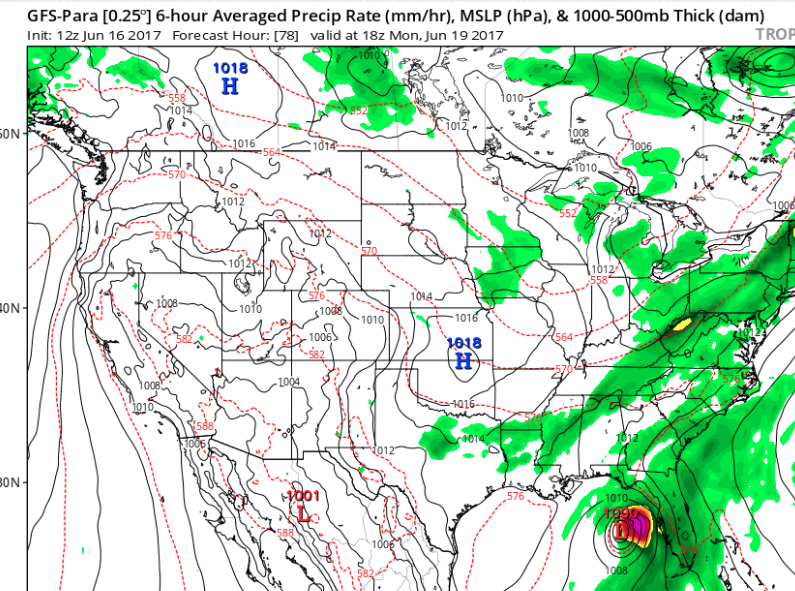
Something called the Para GFS shows development in the Eastern GOM sliding up into the Panhandle so I'm showing it as it's become a quasi favorite of late of some friends.
Then there is the UK Met
There has been some talk of a split down the road on the Caribbean system. Part of the energy goes North towards the GOM coast and another part breaks up and heads for Mexico. Time will tell. Keep watching. Again development currently is being prohibited by strong shear that is forecast to lessen over the weekend. That's why the odds are high over the 5 day and low over the 2 day.
The jury is out on both these systems as we are mostly discussing model forecasting of possible entities. Yes, we have a wave in the Atlantic that we can see and we have a disorganized area of convection in the Caribbean. There is nothing named at this time and we are only talking tropical discussion, be it here ...there or anywhere. The NHC continues to monitor these areas as well as any others that may pop up over the next few days. And, it's worth noting that sometimes if a system is small it often gets missed by models and if an area has multiple centers sometimes the model is only latching on to one center and a transference of energy happens during formation of a named system to the other center. Then the next model run is different from the last model run. There are so many variables. We think of these models like Superman with Xray vision but we are still in the learning process of how to forecast formation several days out. And, again, this year the NHC can post a track for a forecast system that has not yet totally formed. Something worth remembering. Don't say I didn't warn ya...
Is the EURO Superman?
Will the newly upgraded GFS wrestle that title away?
Stay tuned........
Besos BobbiStorm
Ps I'll update as conditions warrant.
Follow me on Twitter @BobbiStorm for faster updates. 92L might need to slow down a bit, but then again it is in search of warmer water and doing pretty good for June.
Location: Miami, Raleigh, Crown Heights, Florida, United States
Weather Historian. Studied meteorology and geography at FIU. Been quoted in Wall Street Journal, Washington Post & everywhere else... Lecturer, stormchaser, writer, dancer. If it's tropical it's topical ... covering the weather & musing on life. Follow me on Twitter @ https://twitter.com/#!/BobbiStorm