Hurricane Harbor

A writer and a tropical muse. A funky Lubavitcher who enjoys watching the weather, hurricanes, listening to music while enjoying life with a sense of humor and trying to make sense of it all!

Sunday, September 30, 2012

Still Watching Nadine..... 10% in Eastern Atlantic


Rumors of development in the Gulf later this week, however no circles are currently up on the map.

Still a lot of weather down in the Caribbean and a constant flow of moisture that will keep pumping up.

Sucky, stupid satellite image ... that I can say sucks and really, honestly someone needs to start dealing with the reality that we are falling way behind the space race...  what if we had a real storm there to follow... a torn page on the right side of the Goes 14... no words...


Not a lot to add. I have a holiday coming up tonight at sundown and I'll be offline until Tuesday night after sundown. It's called Sukkos. We eat outside on the deck in a little hut that we build and it's a Jewish Harvest Festival of sorts. A lot of good food, fresh vegetables, baked goods, flowers from Fresh Market and the weather from God. Will see how the weather plays out. Often times in Miami we get hurricanes and either way am up in Carolina for the holiday. Cool nights, warm days and a good chance of rain as a cold front backs up as a warm front...or so they say. They can't predict the weather here for more than 24 hours in advance so who knows. And, memories of Sukkos that went blowing in the wind in Miami with various Hurricanes that came through on their own schedule.

Life is good. Isn't that the saying of this year... or this summer? Everywhere I went this summer I saw mugs and pens with it on there... so... guess that's the saying of the year.

Boy, am I redundant. Got to run... see you in October and hopefully there will be something more to talk about than the every popular Nadine lol.

Besos Bobbi

Ps... Thank you ...and you know who you are for helping to make my life ... my life. It's obvious a work in progress...


Saturday, September 29, 2012

Watching the Carib... Nadine Still A Cane

Nadine is still a Cane... now let's move on to some interesting satellite imagery..

http://www.ssd.noaa.gov/goes/east/tatl/flash-wv.html

Nice loop....

It shows an interesting area in the Carib that is being ventilated by an ULL to it's west... and currently does not have any circle on the NHC map.

Here's a current image that shows a purple blob, but will update and may change in the near future ... ramp up, or fade away..


Note the missing part of the image which is the best we can do without Goes 13 working....


Note it is currently showing green on the funktop yet... no yellow circle..


Hmmnnnn... let's see if they add in a circle. They will want to wait and see it persist.

Also, over by the shear zone in the image is a wave to the south of Nadine. 

Some interesting things.

Personally... I do think October will find us with some named storms ... 

So...keep checking back...and keep watching...


Sweet Tropical Dreams...

Bobbi

Ps... night time dreams still in black and white like the water vapor loop

Friday, September 28, 2012

Nadine Makes Hurricane!!! lol ... hey it's noteworthy

So now...as she is dancing in the Atlantic she now has the title Hurricane.


5:00 PM AST Fri Sep 28
Location: 30.1°N 35.0°W
Moving: NW at 8 mph
Min pressure: 988 mb
Max sustained: 75 mph

Not much else to say here as she's not going anywhere fast... but she's doing it in style.

[Image of 5-day forecast and coastal areas under a warning or a watch]


Notice the teared, sheared edge on the right of this image... 

I'll discuss this later, but basically the Goes 13 is broke and they took the Goes 14 which always sort of sucked out of storage and got it working.....sort of................and let's hope they can figure out how to fix the Goes 13 because there is no new satellite going up any time soon...

A lot of rain out there... a lot of rain moving into Miami the next few days (more rain) and some rain up in the Carolinas and well... would like to see another real storm some time soon before we officially end the season but for now... Advisory number 65... Nadine is a Hurricane.

Besos Bobbi....


Thursday, September 27, 2012

Historic Nadine Remains.... Up in the Most Storm Day Totals of Any Storms

Enh Infrared Satellite - GOES East 12 hr Loop

There she is all the way on the edge of the world...or the satellite imagery spinning, breathing and alive.

So, Nadine has become one for the record books and is now rivaling the other longest tracking storms we have had since we have been tracking storms. Each at this point has a different claim to fame.

Nadine has now had what we call in the Tropical Biz... 15 Named Storm Days.  Which means obviously, it's been fifteen days that she has been a "named storm" that has been tracked. She alone greatly to the total "named storm days" for what has been mostly a lackluster year with regard to memorable storms. Oddly, this often happens.

How many people here remember Ginger from 1971 ...or would have even known about her had I not written about her awhile back.

How many people here even remember a storm named Esther in 1961? Or... a storm named Faith in 1966? There was Carrie in 1957... that unless you are a big fan of the name Carrie... you may not remember.... or maybe you liked the movie.

Alberto I remember well. My friend and I used to sit online watching him thinking he was never going to go away... Bertha in 2008 was a similar storm.

Esther tracked steady and slowly towards her ultimate landfall in the North Atlantic:

File:Esther 1961 track.png


Faith... much like Esther moved slowly and steady...

File:Faith 1966 track.png


Alberto in 2008 made a loop in the Eastern Atlantic ...


Inez with 9 storms days in 1966 I remember well... very well. I was a little girl... I wanted a storm, a hurricane... after Cleo and Betsy lit up my life I thought that every year we would get a hurricane... alas Inez did some weird dance move that shifted her way from hitting Miami dead on... though we got a few squalls... while AT school.... we did not get Inez. To make matters worse...she stayed in the news for days... the one that got away. She was supposed to move ...at one point.. north over Cuba the way Cleo did 2 years earlier and then she looked as if she was going NE and then she swung ESE and missed Miami and went through the Florida Keys... hmnnnn. I was annoyed, out right pissy and I felt totally cheated. And, then Miami did not get another direct hurricane hit until 1992... with only weak Floyd sort of storms in 1987.

File:Inez 1966 track.png

Then there was Inga in 1969 who looked like she was playing Etch A Sketch in the Atlantic:

File:Inga 1969 track.png


Some storms do eventually hit land... and make landfall. But, they are just very, very, very, very slow movers. Such was the case with Beulah in 1967.


Nadine now goes down into the meteorological history books with the other slow trackers and long trackers shown above.

Stay tuned...she is moving to the WSW at 6 knots which means she will keep tapping into warm moisture, possibly into October...depending on if anything can pick her up and take her finally out to sea.

Besos Bobbi

Wednesday, September 26, 2012

Nadine... Advisory #58....

This sort of says it all:


09/26/2012 10:49 PM EDT


This is advisory number 58....

Oh, she's going SW... s l o w l y.

Soon to break records for longevity. But, you know what they say today...

Fifty is the new forty...

Oh...and there is a new yellow circle. Maybe they will meet and have drinks...

Stay tuned.. more tomorrow ;)


Besos Bobbi

Ps...Can't wait to see what #60 says...

Tuesday, September 25, 2012

"Pesky Nadine" Moves South...


Love the 11AM Advisory out of the Hurricane Center. Cute.... "Pesky Nadine" ... love it.

"000
WTNT34 KNHC 251452
TCPAT4

BULLETIN
TROPICAL STORM NADINE ADVISORY NUMBER 52
NWS NATIONAL HURRICANE CENTER MIAMI FL AL142012
1100 AM AST TUE SEP 25 2012

...PESKY NADINE FORECAST TO TURN SOUTHWARD...


SUMMARY OF 1100 AM AST...1500 UTC...INFORMATION

[Image of 5-day forecast and coastal areas under a warning or a watch] 

So, now that she is going to move "south" she will most likely hook up with the warmer energy of the much warmer water and show more color... intensify a bit and possibly become a Hurricane. That quasi forecast is NOT a "sure thing" but a definite possibility.

She may just stay a piddly, pesky storm named Nadine. Either way ...she's here to stay a for a while.

As for me.. I'll be gone tonight and tomorrow for the Jewish Holiday of Yom Kippur.

Saw this online the other day and it said it all ;)


See you all Wednesday Night as my holiday starts tonight... and I'll be off... As a  matter of fact, getting ready as I type this to eat a big meal and be together with family before lighting the Holiday candles.

Keep watching the area near Florida... you watch it long enough, something will probably form...

Besos Bobbi 


Nadine 2012 VS Ginger 1971... a Look Back at Another Long Tracker..

I thought I'd show everyone another storm that is a mirror sort of image of Nadine, but she did her "I wanna go back" dance in the Western Atlantic.

Let's go back to 1971, Carole King is singing "It's too late baby" and Ginger is not listening. Ginger the Hurricane not Ginger from Gilligan Island...though maybe that is where the guys at the NHC got the name from.. you never k now..

On today in history, Ginger was working her way back to the East Coast after traveling half way to Europe


Also making a dip to the south much like Nadine is doing currently in the Eastern Atlantic.

See below:

[Image of areas affected by tropical storm and hurricane force winds]

Storms like this happen....they just don't happen often on a regular basis but they do happen. So, I thought I'd point it out.

Just not going into all the storms in the Pacific ....this is mostly an Atlantic blog with the rare exception of some "oooooh or awww" but the Pacific is busy in several basins.

Miriam off the West Coast of Mexico catches my attention as she is beautiful, and I have a a daughter named Miriam ;) so ... going to post a picture. Again, she is forecast to move towards the north eventually and into Baja Mexico... her moisture will find it's way as "rain" into Texas and the Southwestern parts of the US of A. So remember.... once a hurricane falls apart.... the rain has to go somewhere.... just a reminder of how the whole process of tropical moisture and the rainfall totals in far away places are all connected.


Besos Bobbi
http://www.youtube.com/watch?v=qISV2HaPpZU&feature=related

Ps...did you really think I was going to post that old sappy love song :P nah.... and though I did think of posting "Healing Rain" from MWS...how did my youtube  know that?? Hmnnnn... nah.... am posting this one as we are doing an Oldie Goldie with Ginger and... September is always hard for me in ways... I lost a best friend in September .... end of summer... end of childhood.... then again I had a few good kids in September... and well.... with this storm it might as well rain until October...which it IS doing in Miami that is getting crazy, record amounts of rain this month. They would have gotten less with one fast moving Category 1 Hurricane... oh the woes of tropical weather...

Monday, September 24, 2012

Nadine and Miriam and Moisture Trains

Interesting to note that the moisture from both tropical systems on the map are finding their way into other areas that don't always receive tropical moisture.

Look at the moisture trail going east into the Mediterranean as Nadine goes WNW.


Look at the moisture trail from Hurricane Miriam in the Pacific... as she moves further north her moisture trail will train into the Sonoran Desert across Mexico and towards Texas.

Just an interesting comment other than pointing out the obvious that another front is draped down across Florida.

Keep watching...

Visible Water Vapor - Hemisphere 12 hr Loop

Besos Bobbi
Ps... pretty picture ... pretty world from up there in outer space ...note the moisture feeds into the frontal boundary draped across the Gulf of Mexico.

Sunday, September 23, 2012

TROPICAL STORM NADINE... officially back

TC Activity

Official...

Track:

[Image of 5-day forecast of predicted track, and coastal areas under a warning or a watch]

Models are in better agreement this time around... keep watching to see if they begin fighting again..

Besos Bobbi

Ps.. Tropical Weather, got to love it!

Nadine 90% Chance of Reinstatement ... She's Back...and Looking Good!


Nadine's Remains have "regenerated" and the probability for her to be reinstated with advisories is up to 90%


Pretty storm. She looks better now than she did before... go figure. YES...that IS Nadine up above.

Look ... a real tropical looking storm...


So, now what? Really can she go through the Straits of Gibraltar????

What a difference warm water makes.......................

Besos Bobbi

Ps... Be back with more information after they reinstate advisories...


Saturday, September 22, 2012

Remnants of Nadine 40%. Chance of Redeveloping... Maybe ;)

Ever have a pimple you just can't get rid of?

That must be how the NHC feels...

Seems she missed Portugal and Spain and England and every other place she was supposed to go over weeks of forecasts... oh well, as an old boy friend used to say "you win some, you lose some" and they lost this round. Hey, they may get another chance soon...

Bottom line
.. Nadine went South towards warmer water... from the NHC below..

"SHOWER ACTIVITY HAS INCREASED SOMEWHAT DURING THE PAST SEVERAL HOURS
IN ASSOCIATION WITH POST-TROPICAL CYCLONE NADINE...LOCATED ABOUT
575 MILES WEST-NORTHWEST OF THE CANARY ISLANDS.  CONDITIONS ARE
EXPECTED TO BE MARGINALLY FAVORABLE FOR REGENERATION OF THIS SYSTEM
INTO A TROPICAL OR SUBTROPICAL CYCLONE AS IT MOVES OVER SLIGHTLY
WARMER WATERS DURING THE NEXT DAY OR TWO.  THIS SYSTEM HAS A MEDIUM
CHANCE...40 PERCENT...OF BECOMING A TROPICAL OR SUBTROPICAL CYCLONE
AGAIN DURING THE NEXT 48 HOURS.  ADDITIONAL INFORMATION ON
POST-TROPICAL CYCLONE NADINE CAN BE FOUND IN HIGH SEAS FORECASTS
ISSUED BY METEO FRANCE. "

Images are iffy but if and when she gets further south into this area... we may have to deal with her again... officially.


Keep watching....................the fun never ends lol.

Okay seriously... at 10:49 AM this morning ...around the time of the Tropical Update on TWC... we hit Fall... or Autumn if you prefer. What is the difference I'm wondering.

I did note some yellow leaves wafted down towards the ground just about that time. My mother asked me when I am coming home to visit her... ummmmnnn. After fall if I have anything to say about it. I missed most of it last year and as I have missed most of the hurricane season that missed giving us many chasing experiences... I really do not want to miss Fall. Especially, as you get a nice mix of turbulent weather when the warm wind from the south hits the cold air from the north and provides us with welcome thunderstorms, rain and very windy weather.

To be fair.. I did get to drive through Beryl.. which was a new experience as it was the middle of the night, forested and not like being on the beach in Miami but it was memorable. It was not much of a storm though ...

The whole summer has been like that... we filled our dance cards with unmemorable dance partners and bragged about how many times we danced and partied, but years from now no one will remember any of the storms except for maybe Isaac.

Well, as they say, the season is not over.

Neither is the Oklahoma game... going to watch the Sooners play football while doing other things and I'll be back tomorrow. Still watching that frontal boundary down near Florida, they are getting slammed with rain. Always watch frontal boundaries. Also, watching the one that is supposed to come through here later tonight.

Nice day today... beautiful day today. We all ate lunch out on the deck this afternoon... staring at the way the sun hits the leaves, watching squirrels do squirrel acrobatics as they raced from tree to tree and watching the leaves slowly begin to fall.

I want weather. Plain and simple.

I want to live a life extraordinary to quote an old song and I really think I need to find a new family to quote lol.

I don't like settling. I'm not boring. And, I like real weather!

Besos Bobbi

http://www.youtube.com/watch?v=tBYxg0Ddg0I&feature=related
yeah.... great song ;)
now we need some extraordinary tropical weather...


Friday, September 21, 2012

Nadine Moves South, Contrary to the NHC Discussion... Bad Girl. Azores Air Force Base....


You know sometimes a girl's got to do what a girl's got to do and in this case Tropical Storm Nadine has sort of given Avila the finger and decided to go South when he said she was going SE. And, imagine they will retaliate by making her an extra-tropical, sub-tropical, "we don't want to deal with her anymore tropical" and write this little puppy who refuses to grow up and go where they want her to go ... out of the Tropical Script. Sort of like being left on the cutting room floor because she would not sleep with the producer or director or well you get the idea.

She has been doing this for days. They could have written her off days ago with some meteorological, psycho babble about how she is lacking this or that and her wind speed and convection is scanty and they have done it before many times with a storm this far away. She has missed the Azores.. no need to worry anyone on the air bases there. Oh ... you didn't think there was a reason we have been watching her so carefully. Azores Air Force Base. It is often used to evacuate personnel from Africa and other European regions... think about it. Africa.. Libya.. this isn't Cocomo darling. There is a purpose behind everything the government does and the NHC is a government agency. That also means they have to verify their forecasts and compete for money along with everyone else and show their worth and value this year and every year. It's not Accuweather or Wunderground..

http://en.wikipedia.org/wiki/U.S._Forces_Azores

This isn't all about taking sexy shots from the beach as hurricanes make landfall, it's about security, watching shipping lanes (including our Naval Ships) and protecting bases, American people affected by tropical weather and providing meteorological information for other regional agencies that share and utilize our information.


Azores Air Force Base. Great picture below showing how much weather they get..


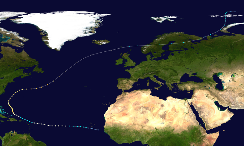
Map showing the Azores geographic importance to Benghazi and the general North African region and for NATO.


Let's go in a little closer... the red dot in the middle of the ocean is the Azores Air Force Base.

Here is Benghazi... lower right corner of this map... Bingo Benghazi I like to call it...


Oh...there's also the forecast track from the NAVY site:


Yes the Azores, are a great place to go with a close friend for a nice vacation.. a lot of history in the Azores. But, in our case it's a military priority to keep an eye on the weather their...especially this year.
Note the 5AM discussion by Avila, and I use him by name as he often puts the "I" word into his forecast discussions unlike most other forecasters.

"NADINE DOES NOT LOOK LIKE A TROPICAL CYCLONE ON SATELLITE...AND ITS 
FUTURE IS AS UNCERTAIN AS IT WAS LAST NIGHT. THE CENTER IS DEVOID
OF THUNDERSTORMS...AND THE ONLY CONVECTION IS WITHIN A BAND IN THE
SOUTHWEST QUADRANT. SINCE I DO NOT HAVE ANY NEW DATA...AND THE
CIRCULATION APPEARS TO BE VIGOROUS ON SATELLITE...THE INITIAL
INTENSITY IS KEPT AT 55 KNOTS. NADINE IS FORECAST TO BECOME A
POST-TROPICAL CYCLONE WITHIN THE NEXT 12 TO 24 HOURS."

Note the 11 AM discussion and note that the 8AM position update said she was moving SOUTH. Actually, they do admit she was going a bit south... even west of south but they call it a temporary motion and they stick with her long term path. Is that like saying it's only a short term track problem, not a long term track problem?? Either way, Brennan is kinder to Nadine than Avila was...

"NADINE REMAINS A MARGINAL TROPICAL CYCLONE. MODEL ANALYSES AND PHASE
SPACE DIAGRAMS SUGGEST THAT THE CYCLONE REMAINS WARM CORE...WHILE
SURFACE DATA AND SATELLITE IMAGERY INDICATE THAT THE CENTER OF
NADINE IS SOUTH OF THE FRONTAL BOUNDARY DRAPED ACROSS THE AZORES."


They will soon write Nadine out of the script and the season will go on without her.. although with or without a name her weather will remain and it will move east.. eventually... towards some part of Europe... maybe even Africa. Maybe stray rain from Nadine will fall over Ben Gazi... who knows. Who cares? We care... because we love weather everywhere... especially when there isn't much else to write home about. Then again if she does move back towards the Azores they may be stuck with her for a while... observations have been picked up that she still has strong winds ... hmmmnn.

In fact, I haven't written on it and almost did yesterday but all the weather mets are going GaGa for a storm that is down near Uruguay. Yup, I said "down near Uruguay" which doesn't get "tropical like storms" often but does here and there and this year is a here and there and now.

Been reading on it. Not sure whether to mention it or not, but it's weather and everyone else is talking on it now so why not.

http://www.ctpost.com/news/nation-world/slideshow/Storms-pound-Uruguay-49328.php
The picture below is from the above article of waves crashing over a sea wall.

High waves from Rio de la Plata River crash over the sea wall on to an avenue during a heavy wind storm in Montevideo, Uruguay, Wednesday, Sept. 19, 2012. A powerful storm blew across the southern cone of South America, breaking windows in several buildings in Uruguay's capital, toppling about a hundred trees and cutting off three highways due to flooding. Photo: Matilde Campodonico, Associated Press / AP

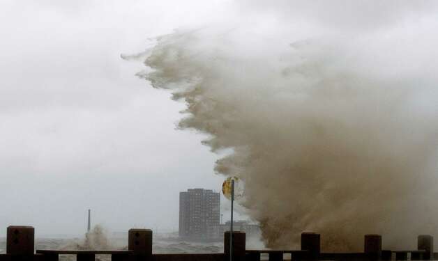
Seems someone down under in South America got weather, they also had several deaths so far and that number may climb.


http://www.google.com/hostednews/ap/article/ALeqM5i5IvtgnS2uPos2AInOM8YD6LSW1A?docId=c71bdc7548f249639287d52b0bfae2ba

Everyone's talking about it... even the Chinese are talking about it... to quote an old song. I don't think we have any bases there ... but TWC has contracts with advertisers in the travel business so they are talking about it..  reminding all of us that it is there... somewhere to the south, below Key West and the Caribbean... our own American Land Down Under :)

http://www.chinapost.com.tw/international/americas/2012/09/21/355038/9-dead.htm

So... lastly, the very last thing I am going to mention is that we STILL need to watch the Caribbean as that area most likely will get hot in a few weeks and the weather down there now is probably just a week or two, maybe ten days too early for a storm to form. Lucky Florida...however... with or without a named storm they will be getting slammed again and again this weekend with wet weather, rain and storms. Another day in the neighborhood for South Florida in September and September turns into October and that is when we get hit by storms from the SW... very wet storms I may add.

Is this beautiful or what? My friend Phil posted this on Facebook... a lot of great images on Facebook.


MYami :) love it... love every little thing about it...
http://www.facebook.com/phil.ferro <--- good source for local info and a good guy as well as a kick ass meteorologist!

Read up on the Azores and their military importance!

Besos Bobbi
Ps ...for the very beautiful Yaffah ;) (almost sounds like a harp there...giggling)

http://www.youtube.com/watch?v=RFX3cICJh34 
http://www.milpages.com/blog/393
http://seanlinnane.blogspot.com/2010/06/worlds-strangest-military-bases.html

Thursday, September 20, 2012

Nadine and the Red Invest and Mrs. Doubtfire.. what they all have in common


The world is a beautiful place... especially when you are looking down at it from outer space.. snapping images like we do Instagram at the restaurant of our favorite desert.

Look at this system... that has a 60% Red Chance of forming... though to be honest it looks pretty well formed to me.


I mean she or he or whatever "it" will be sort of owns the Atlantic Ocean. Looks a lot like Leslie did, except that Leslie was a named system and different... but similar. All storms are different but similar.

As far as it's track? Well, we've seen this movie before. Seems to be a popular theme this season.


Not much to add except ....watch her spin and enjoy her beauty. I mean his. Well, if it makes the name Oscar that is... otherwise it's just an "it" ... this situation is fluid. Tropical Weather is ALWAYS fluid.
That is what we love about tropical weather... 

Elsewhere in the tropics... 


Do you notice that the ITCZ sort of looks flat. I mean if that was a patient's heartbeat it would have died or at least been a Code Blue.. or is it Red? Well, you know what I mean.

It's still worth watching the end of the frontal boundary, though the flow there seems pretty strong and sort of the wrong place in reality for anything to form. But, it happens.

We'll see... waiting to see if the Invest becomes a named storm.. and that name should be Oscar.

Ever notice the name Oscar sounds like Nascar?  It rhymes. Something to remember for the future.

As for me... I'm going to watch the end of Mrs. Doubtfire and try not to think too seriously on the movie. Haha.. seriously... a comedy. Someone reading this understands... oh lord is that in my blog somewhere here too... seriously hope not.

I wonder how heavy that body suit is she/he wore... had to be hot, hot time of year to.. I digress. (Great line..."she isn't real"... when did that ever stop anyone... )

So, with regard to Nadine... it seems she has this thing for going Southeast...

"SATELLITE AND MICROWAVE DATA SUGGEST THAT THE TRACK OF NADINE MAY BE
VEERING MORE SOUTHEASTERLY.."

What can I say that has not been said about Nadine?

I suggest we all sit back, relax, enjoy the show and pretend she is a reality TV show ;)

Nadine is what she is... and Oscar may form tomorrow... forgive me for saying honestly I want a real storm. A real storm... a real storm to track, to study, to oogle and stare at and watch spin but will enjoy what is on the map currently.

There's a good blog entry here on storms that make their way back to Europe. There was Vince in 2005 and a storm that seems to have hit North Africa...  Thanks Jesse Ferrell for the link...

http://www.accuweather.com/en/weather-blogs/weathermatrix/uk-azores-hurri-1/4511

When I was little... I used to think hurricanes went up north in the Winter and then they came back around the Atlantic in the Summer and Fall. Really. Nadine reminds me of those mixed up childish hurricane dreams.

The problem with Mrs. Doubtfire the movie... is that in my mind it always ended sadly. Yes, the father gets to be with his kids... but they don't end up together. Maybe there is an implication it might work out. Sort of like Electric Horseman... they fall in love and then they agree to separate. I guess the romantic in me wants to have a happy ending. People deserve happy endings. And, you miss people who make a difference in your life ... in one way or the other...and they leave. Oh darn I am quoting my stupid friend again. Sometimes you take a chance on a stranger, but deep down you know they are not really a stranger and sometimes you have to say "what the heck" and take a chance and take a walk on the beach or sit in the really messy station wagon and shoot the breeze or grab your tambourine and dance in the conga line (rolling eyes) and accept people as they are.. especially writers and producer slash directors.

And, sometimes.............you have to just accept a storm what what it is... a beautiful spinning wheel dancing on the water like a Sea Gypsy..

Visible Water Vapor - GOES East 12 hr Loop


Note...

How could someone not know... it's the same loop... I would know. I would just pretend not to to make someone else happy ...

Enh Infrared Satellite - GOES East 12 hr Loop

Maybe those kids needed eyes if they could not tell it was their father and not a nanny...

Sweet Tropical Dreams...

Bobbi

Nadine Goes SE... Invest is at 40% &... Some Interesting Areas to Watch...


There are some subtleties going on in the tropics. Something might happen...and then again nothing could happen. But, there are things to watch that are actually more interesting ...long term...than the 40% Orange Circle in the Middle of the Ocean bound for Nova Scotia.


This loop at 11AM shows us what some of the models have been hinting at. Look at the bottom of the tail of the Invest in the middle of the ocean. Bam... it goes orange and I'm not talking about an orange circle, but orange colored, coded convection at the base of the tail of the Invest... in "tropical" waters due East of Hispaniola. There has been talk that the new Invest could... mind you it's only a "could" spawn a second storm. For the first time I can see on the satellite imagery what the models are hinting at....  


Also, there is an area of convection in the Gulf of Mexico that could develop in a day or so .. if the next cold front does not go as deep and moves more East... and that area lingers, it could fester a bit and form into something.

Next... there is still the area that is connected to the old remnant that the models thought would become Oscar. Shows you..sometimes the models are wrong...

The Invest in the Atlantic...the sub-tropical one... IS beautiful. Like one gigantic pinwheel. Makes me think of having raisin cinnamon bread for lunch which is way too many calories and most of it is on it's way to New York with some of my kids who are driving back from what has become the Bed and Breakfast we run in North Carolina.

Or it makes you want to go fly a kite... up to the highest height..

Okay, I am a bit tropically bored. But, I do not believe the season is over just because the MJO is not in our spot on Planet Earth and............I am a big believer in the MJO. I do believe we would have more development even with negative conditions IF the MJO was here mind you. I think we are in transition to the whacky, weird part of the Atlantic Tropical Hurricane Season known as October and November when storms come up out of the Caribbean and trace doodles on the hurricane charts...  I do believe we are going to have an EARLY winter and probably a WET COLD winter along some parts of the East Coast and we are ahead of the normal curve of when things happen.

As for Nadine.... she may be on the maps through the rest of September... or a good part of it. I'm thinking they should start building a Nadine Wing to the NHC Library... as papers will be written on this storm for some time to come... as to why she won't die. Whatever supplements that girl is taking, I want to know what they are...


Remember that whole discussion yesterday out of the NHC how they were staying north of their model package. Seems Nadine went with the models. I'm waiting to see the first city to be listed in a wind probability statistic... cause she is going to have to do some fancy footwork and loop fast before impacting Africa and or the Cape Verde Islands! Has any storm ever done that? Am sure they have, but I have zero time for Googling new things.

Reminds me of Smokey and the Bandit. Okay, many things remind me of Smokey and the Bandit. But, you have to wonder if the NHC is beginning to feel a lot like Smokey chasing the Bandit all across the country and back... 

Classic scene, enjoy... one of my favorite movies of all time. 


So, we will keep watching Invests and storms in the Caribbean and watching Nadine confound the experts..

Stay tuned... the season is not over until it's over and ... it's not over!!

Besos Bobbi

Ps... A well put together "read" if you have some time on the rest of the story on the rest of the season from the Gang at the Washington Post.


Wednesday, September 19, 2012

Yellow circle 40% ... Looking Good.. Sort of.. Oscar... maybe??


This entry is going to really be "name that image" as to me it looks like a woodpecker inside a hedgehog that needs a hair cut..   (sorry my mind is a bit weird... ) but someone else thought it looked like an Eagle... then again they come from Philly.......   someone else suggested a Pirate Parrot... won't go there..

So, you tell me...what does this look like?

The question is...does it look like Extra-tropical or Tropical Storm Oscar?

People are talking about it on Facebook on Mike's site and there are some flutters of conversation in online message boards...

Sort of sneaks up on you while Nadine does or doesn't go East...


Basically it's Nova Scotia or bust ...

Keep watching...

NADINE... and HOW TO READ THE NHC DISCUSSION


No changes to the forecast other than... she's going to go a little further south.. no surprise here.

Anyone taking bets she will pull out before hitting Africa?

So, going to give a little lesson here on "how to read the NHC Discussion" which can seem daunting at times as it is prone to being difficult to understand if you don't have a background in meteorology or reading between the lines.

My translation is in blue.. and I am putting the words that are important in bold.

THE CENTER HAS BEEN MEANDERING ABOUT FOR MOST OF THE DAY
(meandering is a code word for not getting with the program) ...AND THE
INITIAL MOTION ESTIMATE IS STATIONARY.(my question here is how can she be meandering 
which implies movement of some sort if she is stationary, can't have it both ways but there is a limit
what we can say here so let's just say she is stationary. FORECASTING THE TRACK OF
THIS SYSTEM CONTINUES TO BE EXTREMELY CHALLENGING we are clueless, 
this is totally an impossible task.. couldn't we try and solve the national debt rather
 than forecast this storm?
A PROMINENT BLOCKING PATTERN IS EXPECTED TO EVOLVE AT MID-TROPOSPHERIC LEVELS
we really aren't sure ... in any normal year we would be done with this storm, lets keep 
a level of expectation vs saying it is "forecast" to evolve...
OVER THE NORTH ATLANTIC...RESULTING IN A COMPLICATED STEERING
PATTERN. No $hit Sherlock.... duh...  complicated is an understatement
 THE DYNAMICAL TRACK MODELS HAVE HARDLY BEEN A MODEL OF
CONSISTENCY FOR NADINE. FOR EXAMPLE... useless, totally, totally useless  
THE 5-DAY FORECAST POSITION FROM THE 1200 UTC RUN OF THE GFS
 HAS SHIFTED A MERE 900 N MI TO THE SOUTHWEST OF THE 0600 UTC RUN. yes we said SW
THE TRACK OF THE CYCLONE IN THE 3- TO 5-DAY RANGE IS APPARENTLY VERY SENSITIVE TO HOW NADINE INTERACTS WITH A STRONG TROUGH OVER THE NORTHEAST ATLANTIC AND A MASSIVE
ANTICYCLONE OVER THE NORTH-CENTRAL ATLANTIC.perhaps she has PMS? How old is she now she could have PMS...lets just say she is "sensitive, very sensitive"  IN ONE SCENARIO...THE
SYSTEM IS PULLED EASTWARD BY THE TROUGH. please please please go East
.. AND IN ANOTHER IT MOVES SOUTHWARD yes we said southward as in we could be stuck with her until May of 2013...  AND WESTWARD nodding westward... ALONG THE SOUTHEASTERN FLANK OF THE
ANTICYCLONE. IT IS NOT CLEAR WHICH SCENARIO SHOULD BE FAVORED AT
THIS TIME. AS A COURSE OF LEAST REGRET nice phrase... very poetic, basically six of one and half a dozen of the other... toss up, who knows... " a course of least regret, nice ...THE OFFICIAL FORECAST
SLOWS THE MOTION TO A CRAWL IN 4 TO 5 DAYS. how many ways can we say stationary??
THIS IS A LITTLE SOUTH OF THE PREVIOUS FORECAST we said south...we know we said south  AND NORTH OF THE LATEST MODEL CONSENSUS.  we don't buy the models and do not believe this is going to end up as far south as they think it could...   we are trying to stay between our previous forecast and to the north of the models which are obviously whacky and erratic. 


My translation and mine alone... based on experience and knowledge and got to give them credit because if they could write this storm off they would... beginning to remind me of Emily from 1993.
A meteorologically minded friend :) told me once that it looked like she was trying to trace Alfred Hitchcock's head in the middle of the Atlantic :) and he was probably right ...he was usually right.

File:Emily 1993 track.png

Note.....................they often make the long trek back, but rarely do they get as low to the SE as Nadine has...


More later...

Besos Bobbi
Ps... the wave is still firing up in the Caribbean and there is a wave coming off of Africa that I have no idea what it could possibly be thinking... possibly a death wish... unless it thinks Nadine has attacked the Saharan Dust from the North???  Who knows... keep watching as we move through the peak of this erratic hurricane season of 2012...