Hurricane Harbor

A writer and a tropical muse. A funky Lubavitcher who enjoys watching the weather, hurricanes, listening to music while enjoying life with a sense of humor and trying to make sense of it all!

Wednesday, August 31, 2011

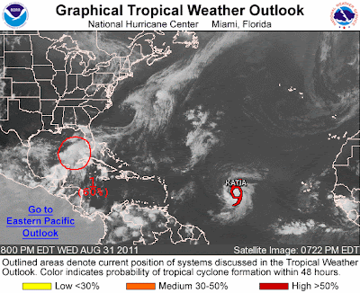
Katia & Storms That Have Yet to Form


So, I'm watching a Red Sox/Yankees game and the moment I start watching the Yankees come from behind and tie up the game. Am I a superstitious person? I don't know but if it's 3 and out in the next inning for the Red Sox I may turn it off.

In a few days we might have three storms on the maps.

What will Katia do? Probably curve out to sea, but just as probably she could move back towards the west and flirt with landfall. The reason we can't say for sure she is a fish is because other things are happening in the tropical world that have not happened yet.

We live in a world of models predicting development and they are currently doing that. Oil rigs are already pulling people off oil rigs and there is not even a tropical depression. Why? Private sector meteorologists who do private forecasting for specific companies and they don't have to worry on anything but getting their specific forecast correct. If they are wrong, clients don't keep paying them.

There are some funky models that show the system in the Gulf doing kinky things that cannot be properly explained here. It forms, it loops, it loops dee doops.. and if it does form will it have any interaction with Katia far off in the Atlantic moving west fast.

This is the graphic that shows mariners, going into a Labor Day Weekend where there might be hazards.


Tomorrow I will do a more in depth blog. Yesterday was traveling day and today was getting back to normal day. Am sore from Pilates and annoyed that the Red Sox are currently losing 5 to 4 of all scores to the Yankees.

Only time will tell what forms tomorrow and where exactly it will go.

Currently the Gulf Coast from the Tx/La border to Florida better pay attention tomorrow morning.

As for me... Jason Varitek just made a Home Run. Tied score.

Maybe tomorrow night at this time we will have two storms, for tonight it's just all speculation.

Sweet Tropical Dreams

Bobbi
Ps... I'm fine, just really tired from traveling and need one night to relax a bit more before I start going model crazy ;)


Sunday, August 28, 2011

IRENE.... Gone, but left a legacy of Inland Flooding


The irony of tonight is that although Hurricane Irene is gone, far away up in Canada somewhere.... her misery hangs on in the form of inland flooding and a climbing death toll.

This has always been an issue for me that bothered the heck out of me. Everyone focuses on the landfall, the sexy photo shot that the media races to get first...

"Coney Island Beach"

But, the beach took the storm just fine and up, far away, inland people died in motel rooms from floods and being rescued just in time from roof tops, a lot of people have died and the death toll is still climbing. Each death a personal drama with mourners and sadness and regrets of "what ifs" and what might have changed the end result. Just one or two different decisions and maybe... just maybe.... what if...

If only there was as much emphasis on the effects of Hurricanes far inland and less of a reliance to let the National Weather Service cover that part of the story.

I'm sorry...but it's like the NHC is Superman and the NWS is the understudy that no one pays attention to in the real world. That's wrong, because the NWS does their job and they do issue warnings but they do it in real time as the effects of the storm become evident, when the final path is figured out and when we figure out which model was right. There are no 3 day Flash Flood Warnings put out by the NWS and people who are glued to the television are only watching the cone put out by the NHC.

Reality bites and it bites hard far away from the beaches and points of landfall.

My daughter was out already at the beach in Brooklyn I believe, others I know went early on... staring out at the water and feeling the wind. Upstate and beyond the metropolitan areas the drama is still going on and will continue going on after Katia forms off the coast of Africa.

She's already gone, but her misery lives on and on.

http://www.youtube.com/watch?v=6BWvqPm6GbU

Links to some sad stories that are still being played out tonight while Brooklyn and NYC cleans up.

http://www.stumbleupon.com/su/1s2CJA/www.vosizneias.com/wp/90278/2011/
08/28/brooklyn-woman-trapped-in-motel-found-dead-by-rescuers/

http://www.stumbleupon.com/su/1uVw8g/www.vosizneias.com/wp/90281/2011/08/28/
sullivan-county-ny-urgent-update-upstate-summer-residents-urged-to-remain-indoors/


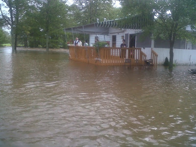
(That's not a scene from the movie Houseboat...that's the real thing)

Vermont is really underwater in some areas, put "Vermont" into a Twitter feed and it goes on and on and on... miles of misery that Irene left behind.

.....for me it's been a long day after a long night and I'm going to bed early. It hit me tonight that it's Sunday night and the radio is quiet in my house and yet the song is playing on and on with all the illogical fragmented lyrics swirling timelessly in space so am ending this hear and putting up one last song.

For Matt:

http://www.youtube.com/watch?v=6iP0q1xIkB4

Sweet Tropical Dreams,

Bobbi


NY 1 - Irene 0 Makes Landfall at Coney Island .. little damage in Brooklyn...


This was for the NYC area mostly a tree trimmer storm.... as my son says, the word of the day is "foilage" and there is a lot of it all over Brooklyn and the rest of NYC.

As I said a few days ago after being at the beach with Irene... she never seemed to have the punch on the ground that she had up at flight level where her winds seemed stronger. Just a strange storm, large, hulking, big, lumbering her way north steadily and yet... mostly rain and flooding.

People are already back at the beach on Coney Island doing ummmm their thing that people do on Coney Island Beach I suppose. Great pic from Twitter:


Oddly other areas far from landfall are getting stronger winds than Crown Heights and Boro Park and Flatbush got and that's where most my sources were tho friends in NYC said the same.

The beaches on Long Island that were just right of the "eye" got the most storm surge and impact as beach cities often do. The lifeguard station came lose and blew into the pier on TV for all the world to see. Staten ISLAND had problems... and NJ has had a lot of minor damage and power is out to the multitudes there... not in NYC but in NJ, go figure.

North Carolina has already phoned home to say the damage was minor compared to other storms, a few piers damaged... minor beach damage, they are still checking and there was that mall in Goldsboro that lost it's roof.

People did lose their lives. It was a big storm that affected a lot of people across a wide geographic area and there will be stories for days to come.

This storm will be remembered by me as when I fell in love with Twitter. I finally, finally got Twitter, loved it... didn't post much as mostly I watched and learned but I will tweet more in the future and this is EARLY still in the season, not yet September.

Some stories worth mentioning:

There is a dog missing in Crown Heights, someone found it...everyone is trying to reunite it back with it's owner ;)

He's male, he's really sweet.... if you know his owner check out Twitter:

http://twitpic.com/6cb79v

Jason Kip took awesome pics and posted them and this is what Irene sounded like in NY:

http://www.youtube.com/watch?v=MO9peQLkxLM

Not much more intense than she seemed in Miami or Raleigh tho at the height of the storm the beach was awesome and the Lower East Side was a little lower and under water. Far from the disaster movie scenario that TWC and History Channel have been advertising.

Info from one of the most beautiful towns anywhere Oriental, NC

http://towndock.net/news/irene-canoeing-the-streets-of-oriental?pg=1

The infamous video from the lifeguard station on TV slamming into the pier:

http://abclocal.go.com/wabc/video?id=8331381

One of my favorite tweets this morning, one that I agree with 100%


HaroldItz Harold Itzkowitz
by nydailynews
.@nydailynews is pummeling the @NewYorkPost and @nytimes on storm coverage far worse than #Irene pummeled the city.

The NY Daily News rocked with the best coverage anywhere... the NY Times did not even come close. Almost as good as Twitter feed...probably better.

LASTLY ....this is FAR from over... it's over in Brooklyn, but not around the rest of the area. There will be WIDE SPREAD INLAND FLOODING from this storm. That drama has just begun....


As to what happened to the South Side of Irene, I've seen a lot of storms weaken but rarely have I ever seen a storm weaken in the way Irene weakened last night. It's like it was a big cherry pie that someone came down and took a bit slice out of from 3pm to 6pm and it was just gone... "poof" and far from landfall in Coney Island there are strong winds on the tip of Long Island and in CT...

Everyone who made it through Irene safely should really offer a prayer of thanks and appreciate how bad it could have been and how many prayers were answered.

Either that or Irene Loves New York as much as most people do...

Prayers for those who are now suffering far away from NY and everyone please be careful, very careful cleaning up the debris and go slow... breathe, enjoy life, be happy and be careful.

And, remember the set up that brought Irene this way could bring another storm in a few weeks or another month.

We are far from out of the woods and really just getting into the thick of the tropical woods as we approach September in a few days.

LASTLY.... PLEASE BE CAREFUL OUT THERE... AS ALWAYS PEOPLE ARE DYING DURING THE AFTERMATH WHEN THEY MADE IT SAFELY THROUGH THE STORM. WIRES ARE OFTEN LIVE AND LYING IN PUDDLES.... BRANCHES FALL THAT WERE WEAKENED WHEN YOU ARE CLEANING UP. THIS HEART BREAKING STORY HAPPENED EARLIER, ALL ACROSS THE AREA IT WILL BE HAPPENING LATER TODAY. OFTEN MORE PEOPLE ARE KILLED CLEANING UP WHEN THEY LET THEIR GUARD DOWN. KEEP KIDS INSIDE, LET RESCUE CREWS DO THEIR THING... LET THE CITY DO THEIR THING AND RELAX, BREATHE AND REMEMBER IT SOMETIMES LOOKS BETTER THAN IT IS... THERE ARE HIDDEN DANGERS EVERYWHERE AFTER A STORM, EVEN A WEAK ONE...

http://www.theyeshivaworld.com/article.php?p=101563

So, keep watching and give thanks and just relax and enjoy the electricity that stayed on and watch TV, eat up your hurricane supplies and give thanks and enjoy life today in Brooklyn.

As for me, I'm in an online class with friends in Crown Heights and around the world which I didn't expect to have as I figured the electric and cell phones would be off. Loving it... after being up til almost 4am with my daughter on Facebook while we watched the Twitter feed together.

Besos Bobbi

Ps... the storm is gone but the danger is not gone, be careful cleaning up!


Saturday, August 27, 2011

Hurricane Irene VS New York City


Well, worst case scenarios have a way of sometimes coming true and in this case this seems to be a worst case scenario. You never know though, sometimes "mother nature" or some force we don't like to name out loud pulls an Ace out from up it's sleeve and sometimes, something changes.


At the moment Irene looks odd beyond words, it's as if the bottom part of her just disappeared on funktop and visible imagery. Will see. Even if she weakens dramatically before actually making landfall somewhere in the general NY/Long Island area the momentum of the storm surge and water being pushed out ahead of her will do damage via storm surge and fresh water flooding.

No matter what happens later this evening or early in the morning water is rushing into the subways, rolling down the stairs like little waterfalls down, down and further down into the subterranean world that is the NY Subway/Sewer system. How many people have watched as Superman had to go down there to deal with Lex Luthor or some such villain hiding out down there causing mayhem in the city above...or was that Metropolis...or was it NY? It's all the same... really... but is there a Superman to save the day?

Either way no matter how high the winds get...or don't get.. New York trees are not meant for storms like this and they break and fall down onto cars and block the streets below.

Even a best case/worst case scenario and it's gonna be a mess.

Further south in North Carolina the flooding in New Bern and Oriental was bad and damage along the coast from the high surf ripped apart piers and coastal structures. Here and there a tornado ripped the roof off of a building or complex. Raleigh managed pretty good, all in all. Everyone I spoke to is so far okay, hope that is true for everyone I didn't speak to... There was a lot of damage and there will be a lot of clean up. North Carolina is used to cleaning up...

And, the clean up will continue up the coast from Baltimore to Dover to New Jersey and well into New York and beyond into New England.

It's sad because it seems to be a real lose lose scenario. Either NYC gets slammed by a catastrophe or everyone cries foul and complains that there was hype and overkill on a minor storm. No one will be happy either way, except for those few glass half full types who will smile and thank the Lord and be grateful. Most will complain either way...which is sad because we need more people who smile and think positive and thank the powers that be when the worst does not happen.

As for me tonight, I was mesmerized by the crawl on the ticker on twitter that began to go crazy fast in the last few hours. Talking to one of my daughters who lives in Brooklyn and watching the other live feeds. All I could think of was that they have almost made television no longer newsworthy. Some stations keep abreast with great live tickers of their own.

One of the best tonight is the Daily Post ... they are incredible with the live feed of information.

http://live.nydailynews.com/Event/Storm_Tracker_Hurricane_Irene_2011

TWC has the Dream Team of Cantore and Norcross... one in the studio stuttering and looking nervous imparting information and Cantore out there in the elements howling. I wonder if Cantore deep down ever thought he'd really be covering a hurricane in Times Square or on the Battery? Yes, no ... maybe.

As for me.. I'm going to bed or going to pretend to...

We will know in a few more hours if an Ace was pulled out of the hat and somehow NYC was hit by Irene but if she dodged the big bullet. And, how bad the damage really will be.

It's funny, I was at the beach in Miami when Irene passed by offshore, more of my family was in Raleigh... an equal distance suffering the same squalls I suffered on Thursday up in Raleigh today...and tomorrow morning several of my kids will be dealing directly with Irene in New York City. I'm beginning to think the Meyer family should be working for TWC ;)

Good night and sweet tropical dreams and this will be the last time Irene is used on the list as sadly people died and the damage is torrential... like the rains and so say goodnight to Irene because she won't be around anymore to make jokes about as she is no longer a laughing matter.

Besos Bobbi

http://www.youtube.com/watch?v=Tpl6ncyxLGw

Ps Sorry I was off so much tonight but sometimes even a tropical muse... has to take a break and be inspired and watch the events unfold while waiting for Superman to save Lois and the world...


Friday, August 26, 2011

Hurricane Irene 7 PM Friday Night... So, what really will be?


Track:


I think basically most of New York will have a strong tropical storm. It is possible it will make landfall as a hurricane, but it's unlikely. The winds are decreasing in intensity, however the wind field is growing wider which is normal for hurricanes as they move north.

North Carolina will get a solid hit out on the Outer Banks, however they are pros at this. It is part of their lives, their history and as routine as going to the store is for some people or preparing for a Nor'easter in the Winter. The roads will wash out, a few houses will slide away and parts of the beaches will be rearranged. The outer banks get a secondary sort of storm as water washes over from the Atlantic to the Sound side and back again. Then again, that is why the Outer Banks look the way they do, as that has happened over and over since time began.

The big problem is that even if this storm comes in as a strong Tropical Storm or possible borderline Category 1 Hurricane it still can and will do a lot of damage in the New York area. People forget that Manhattan is an island, Brooklyn has a beach and both Queens and Brooklyn are filled with lots of bays and inlets and marshy areas. Staten Island is...duh an island. Both major airports are ON the water... which could put JFK and LGA out of commission for a day or two best case scenario. The subways can flood. The Holland Tunnel could flood. It will be a massive pain in the neck if the rain does fall and the flash floods do happen. It doesn't have to be a Category 3 Movie Disaster sort of storm... just a good strong Tropical Storm and or Hurricane is enough to make life a real pain in the Big Apple.

Everyone is erring on the side of caution and I am sure many instead of being grateful will be pissy and cry hype and complain. Be happy if all you get is a big mess and not terror at midnight!

Currently she is not strengthening but she is moving steadily towards multiple landfalls.

Here is a great site with intricate detail on flooding and maps down to street level and individual neighborhoods of NYC.

http://googlemapsmania.blogspot.com/2011/08/new-york-evacuation-zones-on-google.html

Use it if you need it and if you don't but know someone who might, pass it along.

http://project.wnyc.org/news-maps/hurricane-zones/hurricane-zones.html

Here's a good link from the Huffington Post on how to stay connected in a storm or try to....

http://project.wnyc.org/news-maps/hurricane-zones/hurricane-zones.html

Good luck...if the towers go all the fully charged batteries in the world won't help you...

From Bobbistorm: Remind loved ones you will call them and let them know where you are staying and not to worry if they can't get through, it usually means the circuits are busy and/or the towers are down. Keep your phone changed nonstop up until you lose power, keep it plugged in and then TEXT don't talk as it uses up less power.

A visual cornucopia of hurricane links and images from "Mike" :)

www.spaghettimodels.com

NC site: www.wral.com <---- the site everyone goes to in the RDU area and beyond.

Again...this is NOT Hurricane Floyd. This is NOT the Great 1938 New England Hurricane.

This IS Hurricane Irene.

From a historical perspective I want to show how storms that have hit the NE and Mid-Atlantic can and have done devastating damage from domes of water that were pushed inland on beach communities and where rain fell in amounts that caused flash flooding.

http://en.wikipedia.org/wiki/Hurricane_Hazel
http://en.wikipedia.org/wiki/Hurricane_Gloria
http://en.wikipedia.org/wiki/Hurricane_Donna

These three ladies did huge damage up and down the coastline both inland and at the ocean.

Another thing to remember about this storm is although it's satellite signature is of epic proportions it's mostly a massive rain event with tropical storm force winds. The cloud cover is only cloud cover far away and the rain and storm winds are closer to the center and the wide area around the center that is rapidly getting wider and the winds decrease in intensity.

Also.... NJ is getting it before NY so all those beach cities such as Atlantic City, Cape May are all under the gun as well.

Lastly.... I really think that it was overkill to insist this would come in up north as a Cat 2 and 3 as now people see it getting weaker in wind speed and they are less likely to prepare or take it seriously. You can't put the milk back in the container so easily so it is what it is... live it, enjoy it, remember it and stay safe in it!

As for me.. I'll be back after Shabbos and will be hoping my kids who are strung out across the Brooklyn area will be safe. As for my NC friends... I think they will be fine.. i hope..

Remember that cell fones go out... they go out fast. Stay calm, don't panic and watch the storm. And, if you never bought a battery operated radio (remember them...) or Weather Radio now would be a really good time to get one and while you are there.. buy a lot of batteries.

Besos Bobbi
Ps...a pic of the beach in Miami as Hurricane Irene passed by offshore. Very South Beach in a storm. Check out the jellyfish up and down the beach in the front of the pic.


Irene Heads to NC and NYC/Long Island then BOS


This is like one of those long, slow, exhausting Yankee games against the Red Sox... a real nail biter.

First though we have to deal with it's approach and impact to North Carolina. The best bet is it will skirt the Outer Banks and inland NC will have some localized flooding and probably tree damage up to the I95 corridor. Raleigh will have sporadic bad weather and in any bad squall far from the storm trees can come down, roof damage can occur and you can have minor annoyances. But, the real danger is Dare County and places near the coast. Also, remember tornadoes can form in bands far from the eye so if you are near the cone...be careful.

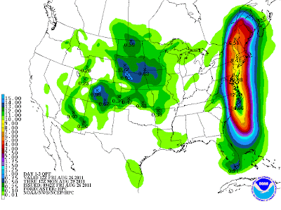
The image above shows potential rainfall from Irene. It's huge. Then again I was in NYC the other day when JFK got the highest amount of rain it ever had in one day. If you add to that the issue of storm surge and more so water being funneled up though the inlets and bay areas around JFK airport that could create a real mess. NYC has said they will shut down subways in advance of the storm so don't delay in what you need to do and hope to catch the last train out of town from the Bronx to Brooklyn before the storm hits because you may spend the storm in the Bronx. If you need to do something, do it now. More so if you are Orthodox and keep the Jewish Sabbath or are a Seventh Day Adventist... do it NOW immediately because Saturday evening the storm will be bearing down and doing whatever it is going to do as it moves towards the NYC area. Storms up in the higher latitudes are fast movers.

In a New York Minute Irene will be there and you will be forced to deal with her up close and personal. The gas stations will be out of gas, ATM machines will not have cash and most of your favorite snack foods will be snapped up by people who didn't not wait til the last minute.

Best case scenario...the storm pulls right and skims Long Island and NYC/Crown Heights/Boro Park and Flatbush will only get strong winds for part of the day and a lot of rain. Those are the cities of my life so that is what I am writing about. I don't know much about Manhattan other than I love to walk around there. Crown Heights I know, it's called "Heights" for a reason so not worried on flooding though if you live in a basement... anything is possible. Flatbush closer to Coney Island is more of a problem. Boro Park should be okay, except again if you are in a basement.. especially one below ground you might want to rethink that...

There is always safety in numbers. If something breaks, if you hurt yourself trying at the last minute to secure a window that popped open...etc.. it's better to have an extra pair of hands.

BIG ISSUE ... AC Units. If you have an AC window unit that is not well secured it most likely will be sucked out by the low pressure and strong winds. It is better to take it out, secure the window and worry on it later. Yes, it is a pain. It will be more of a pain if 70 mph winds get into your apartment, trash your computer, television and your designer clothes or valuable books are ruined. If you refuse to take it out of the window, I'd suggest duct taping heavy plastic garbage bags around it (I know stubborn people) and possibly secure the unit or cover the area... it's best not to let strong winds into your humble abode.

Worst case scenario could be really bad... serious flooding way inland (NJ/PA/Upstate NY) and power outages and erratic looting. I hate to write that but after what has gone on in parts of Europe and in some cities after natural disasters I would not rule it out as an outlying, possible after effect of the storm.

If NYC could not handle a blizzard, how can it adequately handle a hurricane I wonder...

Find a place to stay during the storm. Hunker down. Stay there. Wait for an All Clear on the News before coming out and make sure it is safe to go out. Live wires will electrocute people... the dog really does NOT need to be walked. A mother and her son and the son's friend were killed during a weak storm in Miami because they just HAD to go out and walk the dog... a live wire in a puddle killed them all. Stay inside, you don't need to find a pizza store open on Coney Island Avenue an hour after the storm ended. Stay put.

As for Boston and points beyond in New England... Rhode Island should have a lot of problems with low lying areas and flooding... all of New England may deal with the storm but they will only know after they see if it makes the turn and the lag time between the turn and approach to it's next destination is not very much.

NOTE.. Though improbable it is very possible that this storm can go N..NNE all the way up into Canada and not out to sea.

Lastly the President spoke today from his vacation place on Martha's Vineyard (hope he's following evacuation orders) and spoke on the seriousness of this storm. He is right, it's not rocket science... prepare for the worst, hope for the best.

http://www.ready.gov/ is the site he mentioned first, but know that it is already hard to load and there is a lot of traffic. When your computer turns off because the electric is off you will not be able to go there so go there now.

GAS up.
CASH... go and get it NOW
STASH what you need.

Hunker down and wait it out. Stay safe.

It is personally hard for me to believe this will hit NYC with Category 2 wind speeds, but worst case scenarios do happen. I know because I was in Miami when Andrew drew a bulls eye around the city and headed towards it as a Category 5.

Worst case scenarios do happen... not often but they do.

Here in Miami I went to the beach yesterday. I found Irene much milder than I expected. I hope that is the case up north and that the beaches and cities in her path are on the weaker side and she bears to the right...

But, seriously only time will tell.

As for me I'm taking care of my mother in Miami and can't check in as much as I would like to. I'll post beach pics later when there are not more pressing problems, such as NC and NY and places in between.

I do believe prayers help... prayers for calm and strength and clarity and wisdom to know what your priorities are before and after the storm.

Take care and prepare and I'll be back with my thoughts around 6pm.

Besos Bobbi


Thursday, August 25, 2011

Hurricane Irene Offshore Miami Beach.. Fears for NYC/NE

I'm less worried on North Carolina as they are used to storms and this is par for the course. I mean it could get worse than expected but NC is in prime "prepare" mode and less worried on NC than I am NYC and New England.

If I am not sure yet what to tell my kids who live in Brooklyn there I am not sure what to write here.

For one.. we are getting more rain from bands in the storm earlier than expected according to the 11 PM local weather. They insisted a few passing bands in the morning and more later in the day. A big red blog came at us earlier, I watched it move south over North Bay Village as we drove to Miami Beach. Rather than passing fast over us like the earlier showers this band hunkered down with copious amounts of rain pounding the car and the sidewalk and it's still raining outside. Less wind than I expected, more rain. At the beach it IS windy...very windy, inland not as much.

Yup, sitting here at my old school at Touro South on a computer waiting for that big red spot in the outer band to move past us so I can go back outside and find a good spot to "enjoy" the next blob of intense rain in a band.

What worries me on that is that this huge system can possibly drown the NE and Mid-Atlantic (IE New Jersey and New York) with RAIN... flooding rains like they haven't seen from a tropical system in a long, long time. Might... may... could...not sure if it will. But, the possibility is here.

She would be moving slower than the 38 Hurricane that she's wrongly being compared to, because the only similarity is really the track. She could get absorbed and join forces with the trof making her a massive extra-tropical storm that could cover a good part of the United States in the NE. Could, might, may...will see.
So... my advice to anyone living in NY... inland or on the island and especially in the city is...

STASH
CASH
GAS

Stash up on the necessities... asthma meds, allergy meds, hydrogen peroxide and twinkies and drinks and canned food. Buy water... juice, tea and coca cola if you are a caffeine addict because warm coca cola is way better than not being able to make coffee when you need it. More so.. buy bottled Starbucks or cheap cans of coffee drinks as any coffee in a storm is a port in the storm. Trust me. After Andrew I was like "the hell with all this water, whey didn't I buy soda?" Mind, you we kept filling up used Publix Soda bottles... 3 days after Andrew I wondered why we didn't keep some Publix Cola Soda along with the water bottles. If you smoke... bite the bullet and buy extra cigarettes. Diapers for the babies, more than you think you will need.

Take CASH out of the bank today as there will be LONG lines filled with people in really crappy moods lining up on Flatbush Avenue and the banks and do you really need to deal with that tomorrow if you can do it today. Do not spend it...you can put it BACK in the bank later IF Irene follows the historically correct tracks out to sea and misses NYC and slides past Long Island. The ATM machines run out of cash and at some point the electric most likely will go out.

Gas up the car today. You are going to use it anyway later this week, don't wait for the gas stations to not have any gas and for people to be having fights at the gas station because they waited and are in a crappy mood.

The truth is IF the storm hits a lot of people will be cheerful and "wow we are having a hurricane" and the rest of the population will be in a really CRAPPY mood.

Knowledge is power, no one had knowledge in 1938 that a storm was coming...

The worst thing that can happen is you have extra food, gas and cash.

Obviously, if the rent is due on the 1st and you don't have money for both..buy what is cheapest and you need and pool together resources and stay with others, get some cash, get some gas... hunker down.

Hopefully... this storm will do what most the other storms always did and become weaker and fall apart and move further east but I would not bet money on it.
It's a hard call right now.

Watch what it does in North Carolina and see where she is tomorrow morning at this time.

As for Miami, we are such a magical, beautiful, lucky city to have dodged this bullet and to be able to sit in a restaurant and watch the outer bands slide over us while sipping cafecito and seeing the palm trees bend is about as good as it gets.
Let's hope she is so kind up north. Remember four days ago, three Miami was in the cone so hoping the same holds true for points to the north.

Just think, millions of people up and down the Eastern Seaboard are all looking at that storm and thinking, "Curve Irene, Curve out to sea"

As for me... I'm at the ocean trying to get a real feel for her. Until I see a storm at the ocean, really hard to be sure who she is and get a feel for her.

So far my feel is she is BIG and WET and even if she winds down and is not a Cat 2 or 3 or even a strong 1 on landfall that rain is not going anywhere fast and it will rain itself out somewhere up along the way wherever she goes.

If you live in an area that floods...do not stay there unless you want to get stuck there and if you do..an inflatable boat might be a real good investment.

Besos Bobbi

PS... the storm seems to have slowed down forward speed according to recent reports from recon... oh...okay....

Wednesday, August 24, 2011

Hurricane Irene & A Lesson In Hurricane History


Okay, I'm going to speak straight from the heart here and tell it like it is....

I've been trying not to focus too much on this storm today, because I don't have much to add officially as officially I am towing the line that the NHC has cast and trying hard to believe in their forecasted turn away from Florida.

That's not easy for an "old time Floridian" like me... My family lived in Tampa, Jax, Quincy and Key West before making their way to the Magic City. My roots in Florida go back to the early 1880s. My family has seen a lot of storms and I have to tell you the truth... most of the storms we saw were because the original forecast did not pan out.


Donna stalled and drove forecasters crazy and did her dance across the Keys while we sat for days in the "dirty" part of the storm and the only thing I remember from my first day of school ever was the big Jamaican Tall Palm Tree that had fallen down from the storm across the street from my elementary school. I cannot tell you much about walking into the building (South Side Elementary) which was an old beautiful Miami school from probably the 1920s.... all I can remember is that big palm tree on it's side.

Fast forward to Cleo. The forecasters insisted she would get torn apart by the mountains of Cuba. I loved Bob Weaver but you could read his face when he was watching her make it across and as she bobbled off of land and plopped herself into the Florida Straits that Cleo was looking stronger than they expected. I didn't understand weather back then... I knew maps and I knew his expressions and I knew we were getting Cleo and we did... Lost an avocado tree in the backyard, took days for the neighborhood to cut it apart and help the elderly people who lived behind us. Toads the size of Kansas were sucked out of the ground and buried... honest, why I don't know but Mike across the street insisted I look as he shoveled them into a pile. We lived out near the Glades...


They said Betsy was going to miss Miami and head towards the Carolinas.. there was a front (there is always a front it seems) and she stalled and sputtered and threatened the Carolinas. And, then she turned South...SW... everyone said she was looping and they don't do that long. She did it long enough to stall a bit off the Florida coast and turn west in the Keys giving us the dirty side of the storm.. We used up old Miami News newspapers that said, "Betsy Gone For Good" to catch water leaking in through the jalousies.


They insisted we would get Inez but all we got was more school and Inez went somewhere else suddenly.


By this time... I knew boys were adorable and cute and storms were fickle and they don't always follow the forecast.

Fast forward past those years I lived in LA and missed David from afar the same way David missed Miami... to fast forward to Andrew and let's skip over the small Floyd that came our way and blew down our Sukkoth we erected for a Jewish Holiday in October that specializes in temporary structures...which are easy to take down..

Andrew was headed towards the Carolinas. We had fancy new models and great weather forecasters and we came along ways since Betsy and guess what... The front in
August bombed out and rather than deepening and exploding it went poof in the wind and oh gee wiz but Andrew intensified more than they thought and turned west and never looked back.


I could go on and on... about blown forecasts and dreams that never came true.

The reality is that Hurricanes are fickle in that the slightest change in the atmosphere far, far away on the wings of a hyperactive butterfly can change the course of the storm just enough that extrapolated it makes landfall close to your town or over your town. And, the NHC changes it's forecast in real time and tells you that ... it was in the possible Cone to do that...

Floyd did turn, closer than we thought originally but he did turn.

They are getting better and better. Today we laugh at the old Aviation Model that Brian Norcross showed on tv to explain his fears about Andrew. Twenty years from now we will laugh hysterically at the GFDL and HWRF models and wax poetic on how wonderful our new methods are when it comes to storm forecasting. The one constant is we always think we know so much more and the one constant is that these hurricanes often surprise us. Advice from a Floridian ... don't turn your back on them, watch them and pray and hope they pass our beautiful magical city.

I remember sand being taken out of the lobby of the Deauville after a storm hit that wasn't supposed to hit. I remember a lot. I also remember a few storms that did actually follow the five day forecasted track. You just never know until it's over and it's history not a forecast.

The Gulf Stream Jet is going out again today. I hope it doesn't find any surprises... I do so love that Gulfstream Jet. Please lobby and bother your government officials to allow NOAA more money not less for forecasting tools like the Gulfstream Jet and Recon.. there is no substitute for being in the eye of the storm and being able to measure what is vs what we think we can see from the satellite imagery.

As for Irene.. My son has blinked and we are going shopping for school supplies. He goes to the Hebrew Academy on Miami Beach a block from the ocean and school starts tomorrow. I'm buying school supplies vs hurricane supplies today. It's his senior year. He will look back and remember what I remember from my first year of elementary school. Hurricanes and the Start of School in Miami go together like notebooks and uniforms. And, although the notebooks are now electronic... hurricanes and the start of school are Miami kid's memories. It's just that time of year in Miami, we call it Hurricane Season.

It's a great school. A great place to live. A great way to live. Sometimes hurricanes come and rearrange the landscape a bit but in the end, there's no place like it anywhere and I've lived a lot of places.

So, crank up the AC and put on a happy face and pretend to believe the forecasters and don't worry about Category Three Hurricane Irene moving our way and closing in on Category 4 status and do not think about the Great Miami Hurricane of 1926.. or Betsy or Andrew.

The 11 AM is out... she's moving NW (big smile and sigh) and I'm going shopping for school supplies. It's okay, my brother has a stack of hurricane supplies that will last through the entire 2011 Hurricane Season ;)

Just listen to the music and cast your fate to the wind...

http://www.youtube.com/watch?v=ADPgTmca6Zs

Besos Bobbi
Straight from the heart :)
http://www.youtube.com/watch?v=sfK6NJlKf34

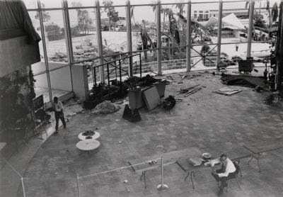
The beach where my son's school is in 1926 after the Great Miami Hurricane... just about exactly give or take a block from the school...

Tuesday, August 23, 2011

Irene, Building a Cat 3 Hurricane In the Bahamas Tonight


First off, I took a little time off today from the computer and decided not to post too much. There really isn't much to say as the models are all in "excellent" agreement and as long as they continue to stay in agreement and no family feud breaks out I am a happy camper and not as worried as I was last night.

As the NHC said earlier, thankfully they have the Gulfstream Jet out there and two other planes and there is so much data coming in ... hard to believe they could be missing anything. Then again if one good model blinks and burps to the west I am going to wake up and worry again.

Meanwhile, the earth decided to put on a show this afternoon and there was a 5.8 earthquake in Virginia that I imagine even Martians in Green Tunnels under the Red Planet heard about! I had 3 phones calls in rapid succession from North Carolina all at the same moment in history. My daughter in Crown Heights texted me and asked me if they were having a quake as well. Just sort of pathetically ironic that as we sit and talk about whether North Carolina will or won't get a hurricane they get a quake. Typical as Mother Nature has a wicked sense of humor.

I really do believe that this storm will most likely just clip the Outer Banks if at all and depending on the angle go out to sea or give Long Island a good run for it's money as it moves north towards Cape Cod and Martha's Vineyard. Not 100% sure but pretty sure.

Please note the nice bumper sticker at the top of the page. Cars all over the Carolinas have those bumper stickers on their car. Do you know why? Because they are one of the most visited spots on the Planet by Hurricanes.

It's possible it will come in lower, but it better stay away from my favorite places in Myrtle Beach.

But, for tonight... Irene is building a Major Hurricane. She is possibly going through some eye wall replacement cycle.. if so watch out. She's going to get leaner, meaner and stronger.

As for me... I could wax poetic on the 19th anniversary of Hurricane Andrew tonight, but I am not going to. Maybe tomorrow morning.

Suffice it to say 19 years ago I was on the floor of an old two story house on Miami Beach feeling the wind slam into the building and at the height of the storm ... at moments you could hear the roar of the Ocean about five blocks away, maybe four depending on how you count Indian Creek. A house to the East of us two blocks away lost it's roof as it sailed off the top of the house on Flamingo Drive and landed in the yard of the house on Pine Tree. A few of the pine trees on Pine Tree came down. I think it might have been a tornado. Who really knows... we survived, we were fine, we were blessed and all of my family and my 7 month old baby girl who spent most of the night underneath me was fine. Today she called me from Crown Heights and asked me if they were having an Earthquake...

Such is the way of the world. This is a living, breathing planet that is always in flow, stretching in all directions. Volcanoes, Earthquakes, Hurricanes, Tornadoes and Tsunamis all contribute to the way the planet looks and feels. The coastline of the United States on the Atlantic side has been trimmed and manicured by thousands of passing hurricanes over time. People are surprised that Virginia had an earthquake? Why? They have mountains .... how do you think they got there? Fault lines..

It's all Mother Nature's fault.. don't you know?

I'm going to bed... hopefully as we sleep the models will stay in perfect, excellent agreement.

Last night I couldn't get Carole King songs out of my mind, tonight they make a lot of sense.

Looping music:

http://www.youtube.com/watch?v=hoHuxpa4h48

http://www.esl.lsu.edu/animate/goes/index.php?region=tropics&channel=wv

Sweet Tropical Dreams

Bobbi


Models Agree on Irene Missing Florida... Aims at Carolinas


The data from the Gulfstream Jet last night helped the models put out better data that was more in agreement and it looks this morning like Florida gets to miss Irene however, the jury is still out on the Carolinas.

I still think this storm is more Floyd than Fran.

I still think until we see the turn take place and she moves north of our latitude or your latitude you don't turn your back on Irene and feel safe.

So... I'd keep watching in South Florida and South Carolina.


I think if it does make the predicated turn...it will keep on turning and only affect the Outer Banks if at all in North Carolina.

Am going to post later after 5 when we see what Irene has done today.

Mind you she is moving slow and she has a lot of running room.

Enjoy the ability to breathe a bit easier if you live in Florida today... go out, enjoy the weather and give thanks and hope it stays that way!

Cause you never really know as tropical weather is very fluid....

Greg Fishel in Raleigh is great and this is an excellent blog with good information for up the coast in the Carolinas and beyond.

http://blogs.wavy.com/2011/08/23/irene-near-hispaniola/

Besos Bobbi

PS... I really LOVE the new wave off of Africa...but for now there are bigger fish to fry...

Monday, August 22, 2011

Can't Sleep... Irene Spinning Down Below... Where will you go Irene


Old haunting tune, just played on the radio... goes so well with this loop. Loop the loop and listen to the haunting song...
http://www.youtube.com/watch?v=nSz16ngdsG0

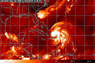
More worried on things I am seeing on the Water Vapor Loop.

http://mkwc.ifa.hawaii.edu/satellite/satanim.cgi?chnl=wv&domain=bah&res=4km&size=large&period=720&incr=30&rr=900&
banner=mkwc&satplat=goeseast&overlay=off&animtype=flash

One last loop... going to bed...

http://www.ssd.noaa.gov/goes/east/tatl/flash-wv.html

Don't like what's behind Irene... that high is going kinky things.
http://weather.unisys.com/satellite/sat_wv_east_loop-12.gif
looping music: http://www.youtube.com/watch?v=mhL36vP_lv4&feature=fvwrel

Not as kinky as this radio...

Hey so far, she's skimmed land and avoided a harsh landfall... changing the channel and going to bed. Hope she avoids everyone in her path..


There's Something About a Cat 4 Hurricane Off of Miami... Irene at 11PM


There's something about a hurricane in the Turks and Caicos that suddenly makes it seem a lot closer to Miami. There's also something about a possible Category 4 storm off the coast of Miami on Thursday that makes even a chatterbox like me quiet.

I've been staring at a loop for a while now, obviously too long and after talking to my best friend and my brother... I'm still not sure what to say except that I have a bad feeling about this and unless she jogs north a lot fast and/or the models pull east fast I think this is about as close at it gets to a worst case scenario for Miami.

Mind you..many a storm has cruised by on it's way north along 77w or 78w. Floyd was such a storm. Somehow though I think this could get closer than Floyd. I remember Floyd well, made several trips to the beach... took tons of pictures and sat late at night watching the foamy surf pounding in. The roar of the wind was the strongest I've heard since Andrew. While taking pics, a wave grabbed me.. I tossed the camera onto the beach and spent the next several days trying to take sand out of parts of my body I do not want to mention on this blog. Got great shots... the sand had a feel to it that I have never felt before. Hard, gritty, churned up from places far away and left behind as Floyd went north. Not your typical Haulover sand...

Reed Timmer tweeted this earlier and it sounded logical and possible. A similar sort of track, though Floyd started out higher and turned faster and it was obviously a different sort of high. Different time of year too.


I like Reed, he's smart and fun and has energy and he's right... similar feel to Floyd.

@reedtimmerTVN
Reed Timmer
Irene reminds me a lot of Hurricane Floyd.. first tropical cyclone I chased. Floyd was initially heading for Florida as well


First storm I got great pictures of myself as it sailed past Miami.
http://en.wikipedia.org/wiki/Hurricane_Floyd

Floyd was a really big, huge system much like Irene is and will be.

Miami has the following wind speed probabilities at 11PM tonight, Monday... pretty high odds if I was a betting person:

FROM FROM FROM FROM FROM FROM FROM
TIME 00Z TUE 12Z TUE 00Z WED 12Z WED 00Z THU 00Z FRI 00Z SAT
PERIODS TO TO TO TO TO TO TO
12Z TUE 00Z WED 12Z WED 00Z THU 00Z FRI 00Z SAT 00Z SUN

FORECAST HOUR (12) (24) (36) (48) (72) (96) (120)

FT PIERCE FL 34 X X( X) X( X) 1( 1) 36(37) 25(62) 1(63)
FT PIERCE FL 50 X X( X) X( X) X( X) 11(11) 17(28) 1(29)
FT PIERCE FL 64 X X( X) X( X) X( X) 3( 3) 9(12) X(12)

W PALM BEACH 34 X X( X) X( X) 2( 2) 43(45) 16(61) 1(62)
W PALM BEACH 50 X X( X) X( X) X( X) 16(16) 13(29) X(29)
W PALM BEACH 64 X X( X) X( X) X( X) 5( 5) 7(12) X(12)

MIAMI FL 34 X X( X) X( X) 3( 3) 35(38) 10(48) 1(49)
MIAMI FL 50 X X( X) X( X) X( X) 13(13) 7(20) X(20)
MIAMI FL 64 X X( X) X( X) X( X) 4( 4) 3( 7) X( 7)

I know I am focusing on Miami but Miami would be one of the first cities to be impacted in the U.S. by this storm IF the high built in or the steering currents shifted. The discussion out of the Hurricane Center tonight was not very convincing and they left a door wide enough to sail a cruise ship through as to just where this storm will be on the 4th and 5th day.

Note below:

THE NHC FORECAST IS HIGHER THAN MOST OF THE GUIDANCE
THROUGH 48 HOURS AND IS CLOSE TO A BLEND OF THE GFDL AND HWRF
MODELS AFTER THAT TIME....

.....IT IS IMPORTANT TO REMIND USERS NOT TO FOCUS ON THE EXACT FORECAST
TRACK...ESPECIALLY AT DAYS 4 AND 5...SINCE THE MOST RECENT 5-YEAR
AVERAGE ERRORS AT THOSE FORECAST TIMES ARE 200 AND 250 MILES...
RESPECTIVELY.

So, I'm going to leave you with this question by my best friend a little while ago:
"what the hell kind of a storm turns into a cat 2 storm while still it's over Hispaniola??" And, she thinks it will be a Cat 3 sooner rather than later.

Going to post some links below and try to go to bed.

As for me.. I plan to go to the beach on Wednesday. I also plan on having strong winds on Thursday. I plan on praying a lot. I have a plan, but really who has a good plan for a Category 4 storm flirting with making landfall in Miami? Will see. It's a long ways away. Just looks closer on certain satellite images, and then.. it will look a lot closer tomorrow night at this time.

I predict panic level in Miami to set in around 5pm tomorrow unless something big time changes with this track.

http://www.esl.lsu.edu/webpics/goes/Storm/Tropics/latest_wv.jpg

http://www.esl.lsu.edu/animate/goes/index.php?region=tropics&channel=wv

Sort of speechless watching this link:

http://www.intellicast.com/Storm/Hurricane/CaribbeanSatellite.aspx?animate=true

An excellent forecaster in Raleigh weighs in:

http://www.wral.com/weather/story/10028170/

A beach I think could get this storm is Ocean Isle Beach, a beautiful south facing beach in North Carolina though it could just as easily could and most likely will affect Wilmington if it affects anywhere. Great place OIB, take a visit and enjoy:

http://en.wikipedia.org/wiki/Ocean_Isle_Beach,_North_Carolina

Let's see where she is at 5am and how big she is and how her track has changed.

Sweet Tropical Dreams, Bobbi


Category 2 Hurricane Irene & Morbid Curiosity


I have received emails from people as far away as Maine and as close as Miami. Everyone seems to have Irene's name written on their house. It's been a long time since I have seen a storm that threatens everyone from Miami north as far as Maine and Long Island.

Truth is there is a hurricane partially over land in the tropics that is intensifying and that to me is an odd thing to happen. Rather than the Dominican Republic taking a bite out of Irene, Irene seems to be taking a bite out of the Dominican Republican as she hovers just off shore and her SW quadrant firmly on land. She has gotten wider, bigger, stronger.


The GFDL had her doing that and I thought the GFDL was smoking something. Now, I'm wondering what the GFDL saw the others didn't see and hoping it's wrong in it's Category 4 Miami landfall scenario. Quietly waiting here for the next run..

Out of morbid curiosity I went down to street level on a fantastic model site and I see it comes in just south of Gables Estates around SW Guadalajara Streets down in Pinecrest, it moves it across Old Cutler Road and up towards SW 125th Street towards Dixie Highway and keeps on going near Dadeland Shopping Center and out towards Village Green off of Bird Road. It's like Irene would be traveling the streets of my childhood. The next run will probably bring it over Miami a bit further to the east near the Road Section and Brickell or destroy Hollywood Boardwalk :(

Of course, there is a good chance that it's going over Raleigh and I'll miss that one while I'm back home in Miami, how's that for irony?

You play with it. Great site Channel 7 has in Miami and a really great job Phil Ferro does going over all possible scenarios. I am very impressed.

http://www.wsvn.com/weather/hurricane/models/

What do I think?

I think that Irene is missing the "for sure" trof and I am not sold on the new system that is supposed to lift her sharply north.

And, it's too soon to tell. A lot depends on Irene herself.

A Major Hurricane carries a large high a loft that tends to sometimes strengthen the high and help it build it vs retreating. They also tend to keep on going in the direction they were going due to inertia and other laws of science I am not up to explaining but suffice it to say... they turn slower and continue on trucking in the direction they choose. It's a factor that is a wild card and IF that happens and plays out, then we will see what we will see.

The incredible Gulfstream Jet is going out later and it's going to sample the atmosphere around the storm and up stream of it where it will go and with that data the next set of models should be much better.

At some point, someone round here is going to have to decide if Miami Dade County and Broward get a watch or warning, glad I don't have to make that call.

And, in Charleston weather people are eyeing Irene as seriously as we are with butterflies in their stomach and dreams of Hugo dancing in their head.

Maybe someone is living in Mt. Pleasant morbidly trying to figure out on google earth just what street Irene slams into their town.

And, remember it's a long way out and models shift and cones track and nothing is set in stone, it's fluid and the world's most fascinating reality show happening in front of us in real time.

I only hope and pray that Irene continues to miss making a dead on landfall as she has done so far... maybe come dangerously close to South Florida (like the NAM) and slide past Cape Hatteras and keep on going missing Long Island? What do you say? Can we make a group prayer here.

All I know is since day one... I was sure that Irene would crawl across the north coast of Hispaniola and go "up over the islands" and beyond that... I am still not sure but I think it's gonna be a close call.

Look at her... Category 2 in all her beauty.


Again... why is she getting stronger over land and which model saw that coming?

HURRICANE IRENE DISCUSSION NUMBER 9
NWS NATIONAL HURRICANE CENTER MIAMI FL AL092011
500 PM AST MON AUG 22 2011

DATA FROM THE LAST AIR FORCE HURRICANE HUNTER AIRCRAFT AROUND 1700
UTC INDICATE THAT THE CENTRAL PRESSURE WAS STEADY AND THE WINDS
HAVE NOT CHANGED DURING THE DAY. SINCE THEN...HIGH RESOLUTION
SATELLITE IMAGES REVEAL SOME CONVECTIVE BANDS WRAPPING AROUND A
CLUSTER OF DEEP CONVECTION NEAR THE CENTER...SUGGESTING THAT IRENE
COULD BE SLOWLY INTENSIFYING

Again... the newest advisory confirms that she is strengthening.

"7:50 PM AST Mon Aug 22
Location: 19.7°N 68.7°W
Max sustained: 100 mph
Moving: WNW at 10 mph
Min pressure: 981 mb"

That's a real ummmmmmmmmmmm and it worries me that the GFDL called that.

Great link:
http://flhurricane.com/cyclone/stormspotlight.php?year=2011&storm=9

Take care and I'll be back later with more thoughts when we know more.

What do I really know? I'm going to the beach on Wednesday, that I know for sure.. beyond that... only time will tell.

Sweet Tropical Dreams, Bobbi

PS... since I hit send the new model came out and takes the GFDL over my friend's house in Boca.... so glad Gables Estates is off the hook. Is anyone off the hook for sure.

At 5PM the NHC Discussion was as follows:

FORECAST POSITIONS AND MAX WINDS

INIT 22/2100Z 19.5N 68.6W 70 KT 80 MPH
12H 23/0600Z 20.1N 70.2W 80 KT 90 MPH
24H 23/1800Z 20.8N 72.5W 85 KT 100 MPH
36H 24/0600Z 21.5N 74.0W 90 KT 105 MPH
48H 24/1800Z 23.0N 75.5W 95 KT 110 MPH
72H 25/1800Z 26.0N 78.0W 100 KT 115 MPH
96H 26/1800Z 29.5N 79.0W 100 KT 115 MPH
120H 27/1800Z 34.0N 79.0W 80 KT 90 MPH...INLAND

$$
FORECASTER AVILA

HOWEVER, in less then THREE hours she was at 100 MPH???
That's a real busted forecast in my eyes, why is the question..

So.... I leave you with this question... I'd like an answer....

The National Hurricane Center predicted at 5 PM that Irene would be a Category 2 in 24 hours. THREE HOURS LATER.... Irene is a Category 2 with 100 mph sustained winds. IF the NHC missed the intensity forecast that badly... I have low confidence in the rest of the forecast. You can't get the intensity wrong and the track right....

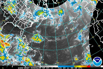
Hurricane Irene at 2pm 80 MPH moving WNW at 12 mph


Quick update here.... and I will post at length later this afternoon after the 5pm comes out.

The Navy puts out a map that is most excellent and worth keeping an eye on:

http://www.nrlmry.navy.mil/htdocs_dyn_pregen_sat/PUBLIC/tc_pages/pages/tc11/
ATL/09L.IRENE/ssmi/gif/full/Latest.html

With every jog west or north the track will change a little bit. it is important to remember that the 4 and 5 day forecast is prone to errors of over 200 miles which is why the cone is so wide at the end of the cone. The 3 day cone is excellent and if you are in the 3 day cone... prepare.

Everyone from Florida to Long Island seems to feel "they will get the storm" and yet there is no lock in on the track. No "for sure" track. Many possibilities and probably closest to what the NHC says currently.

Personally, I feel like if it pulls north it is more likely to pull further north than the Charleston and landfall would be closer to Wilmington. IF the high digs in and the fronts weaken, she will move closer to Florida.. much closer. It's an either or scenario.

It's really a matter of climo vs the storm. Very few storms have taken the track from where she is now to where the NHC has her coming in around Charleston in their current map. I am not saying that couldn't happen, am just saying Irene would be the first it seems.


I'll be back later. If you are not in the 3 day cone... relax, think, watch and stay prepared because again if this one does not get you.. the next one might.

Besos Bobbi

Ps note that this is predicated to be a Major Hurricane... and a Major Hurricane can and often will change the steering currents which becomes a factor down the line.

Sunday, August 21, 2011

Irene Intensifying ... good news/bad news


I know how my mother feels, she is right and I have to admit it. It's the same old story all the time. The newsmen tell you that the high mountains of Hispaniola will disrupt the storm. As she says, "I'm not stupid, been watching these storms for 50 years and then they come off of Haiti and Cuba and hit the hot water and intensify again." And... she's right.

A weak storm that is not "vertically stacked" falls apart over Haiti. A strong storm that IS "vertically stacked" and that is HUGE can make it across Hispaniola a whole lot easier. Then again other factors come into play, such as forward speed. Georges kept on going...

Vertically stacked means vertically it is "together" unlike some storms where the lower level core is displaced from the mid level circulation. When a storm is properly stacked she is like a Diva.... she intensifies rapidly, she evacuates air out properly, she fans out and become a large round ball with bands feeding the storm with more moisture. She becomes a lean, mean fighting machine capable of setting off the same amount of energy as an Atom bomb... or stronger. Katrina and Camille are two storms that are perfect examples.

I am not saying that tonight at 10:30 Irene is there yet, I am saying she could be there sooner rather than later.

I've watched Irene all night, while dealing with some personal family drama. Sort of speechless at the way she is doing her thing down there and we are doing our thing up here...which is watching and waiting. The weather radio says "possible tropical storm force winds or hurricane force winds Thursday" yet everyone online is trying to wish the storm towards their particular part of the world in some morbid fascination with "I want a storm, I want a storm" and then when it's a Major they are suddenly, "No, I don't want the storm, I don't..." Maybe it's the way we deal with life, some moth to the flame fascination.

I'm often accused of "loving hurricanes" and to that I will agree but I like to love them when they are safely out to sea and just close enough for me to go to the beach and feel their breeze.

My mother is right. This is one of those storms and the forecasters will try to explain fifty ways we won't get this storm when we all know it's very possible we will and the NHC keeps their cone just close enough to not be able to sleep well at night.

Tonight is a good night for sleeping, there isn't much you can do. If you are in Puerto Rico it is a bad night for sleeping and a good night for hunkering down and listening to the wind and saying thanks to God that she did not get any stronger.


I tried to convince my mother to go to bed. She's already got her bag semi packed to go to my brother's house, even though her condo here which is well sheltered between buildings and on a low floor and has an inner room is probably safer than Casa Schwartz as we call it. I tried to get her to go to bed, I told her I was going to bed. She told me, "Aren't you staying up for the 11 pm advisory??"

My father had Alzheimer's. She does not. And, she knows a thing or do about reading between the lines when it comes to hurricanes in Miami. She monitors the weather, tries to read every line on the bottom of the scroll as her hearing is bad. Not so bad that she did not hear them say it might be coming this way.

Run this loop:
http://mkwc.ifa.hawaii.edu/satellite/satanim.cgi?chnl=wv&domain=bah&res=4km&size=large&period=720&incr=30&rr=
900&banner=mkwc&satplat=goeseast&overlay=off&animtype=flash

You really don't need to wait for recon to send a report nor do you have to see if the NHC will up it to Hurricane at 11 or just let it flirt with Hurricane strength.

But we will wait...and we watch and that is all we can do with a storm this far away.

My biggest problem with this, other than worrying it's going to make landfall at stronger than a Category 2 is the shear size of her cloud shield. She would cover the state of Florida and half of Georgia at this rate. She is one of those really, big classic Cape Verde sort of storms. She has a high aloft and she's got a lot of living to do... to quote a song.

So.... monitor, plan, watch carefully and in between get out there and enjoy life and the beautiful breeze because that same beautiful, non-stop breeze I am feeling tonight in Miami may indeed bring trouble this way.

Great site for tonight as Irene begins to ravage Puerto Rico:

http://www.stormcarib.com/

My prayers go out tonight to the people or Puerto Rico and the Virgin Islands, they are the ones dealing directly with Irene vs playing a "what if" game.

http://radar.weather.gov/radar.php?rid=JUA&product=N0Z&overlay=11101110&loop=yes

The question remains tonight, how many times can you hit refresh even when you get the advisory texted and emailed to your account?

http://www.nhc.noaa.gov/#IRENE

Okay.... two thoughts on the 11 PM which is finally in...

1... They kept it a Tropical Storm but I really think that's debatable. Not enough definitive information from recon most likely. 70 mph is flirting with Hurricane intensity.

2... Tropical Storm warnings up for the Turks and the Caicos. That is when people in South Florida begin to listen up...

11 PM

LOCATION...17.9N 65.5W
ABOUT 50 MI...75 KM WNW OF ST. CROIX
ABOUT 50 MI...85 KM SE OF SAN JUAN PUERTO RICO
MAXIMUM SUSTAINED WINDS...70 MPH...110 KM/H
PRESENT MOVEMENT...WNW OR 285 DEGREES AT 15 MPH...24 KM/H
MINIMUM CENTRAL PRESSURE...993 MB...29.32 INCHES

3... (extra credit) "TROPICAL STORM FORCE WINDS EXTEND OUTWARD UP TO 150 MILES...240 KM FROM THE CENTER. " Tropical Storm force winds extend out really far, note again what I said about this being a BIG storm size wise.

Nite.... from Miami, Sweet Tropical Dreams Bobbi
Ps... I can hear her moving around out there, my mother... not Irene...she's going to watch the 11pm... going to be a long week around here.

http://www.nhc.noaa.gov/refresh/graphics_at4+shtml/024913.shtml?5day?large#contents


Home in Miami... or as my "friend" calls it "Ground Zero"

He has such a good sense of humor....

To be honest, this far out most of Florida is Ground Zero as is Nassau and Bimini.

It's just too soon to tell and that's the truth.

It's not too soon to stock up on hurricane supplies "just in case" and make a plan.

And, that might just go for you folks up in Charleston as well:

http://www.meteo.psu.edu/~gadomski/GFSTROPATL_12z/gfsloop.html

Every model is whacky this afternoon. One takes it into the Gulf and the other zooms it up offshore Florida into the Carolinas.

Today Miami is "Ground Zero" tomorrow it might be your town...

As the plane landed this morning, the pilot announced a gentle breeze out of the Southeast. And, I thought to myself... "damn" as beautiful as the Southeast breeze is in South Florida it is that very same Southeast Breeze that could bring Irene this way...

This is why we love www.flhurricane.com...excellent discussion and analysis as always:

http://flhurricane.com/cyclone/showflat.php?Cat=0&Number=91345&page=0&fpart=2&vc=1

The 12Z Model Run Down:
GFDL does not really grasp it at all, and shuffles it to the west and keeps it an open wave.
HRWF takes it over eastern Cuba and the run ends just before approaching South Florida. as a hurricane
EURO In caribbean, south of Haiti, through Eastern Cuba, up into South Floida and along the spine of Florida along the eastern side of the state. as a hurricane
GFS Operational: In Caribbean South of Haiti, Through Eastern Cuba, up into the Keys Friday, and straight up the center of Florida, leaving the dirty (NE)( side of the system in S. Fl, E CFl, and Jax. as a hurricane
Canadian: In Caribbean, Over Jamaica, over Western Cuba into the eastern Gulf. Run Ends before US Landfall.
NOGAPS: Caribbean, over haiti, eastern Cuba, into Eastern Gulf, and then near Tampa at end of the Run.
TVCN: Into Southeast Florida, and through the Spine of the State, out at Jacksonville.


I can't say it better that that. But, if you live and die by the models you will have a nervous breakdown by Tuesday, possibly Monday... They will swing back and forth and the National Hurricane Center will do the best job it can do to unscramble all the data and put it into a reliable format that we can all understand.

NOTE: That scenario over Florida with the East Coast cities being on the Dirty Side would be a bad scenario and effect many, many people.

People are shopping a bit today. Publix is putting out the water and batteries display, the water is slowly going. They will restock tomorrow. A lot depends, they told me, on what the track is at 5am tomorrow. We take it day by day, sunrise by sunrise in the tropics.

So... until we get to a strong 3 day cone with Miami in it... I'm not going to panic. Just going to do my thing with my friends and watch the storm as she moves west towards Puerto Rico.

Besos Bobbi
Ps...watch for the models that stay the most consistent, not the ones that wildly go right when the storm temporarily "relocates" a bit more to the east or north or etc, you get the idea. Watch the storm and she is forming a CDO which looks a lot like an eye, yet they insist she isn't stronger wind wise... hmmmm. Easy to say some dry air has entrained itself into the storm but in the exact middle of the strongest convection? That's a big "hmmmmmnnn" and I'm curious to see what they will say at 5PM. For now the 5 day forecast in Miami is for "wind" on Thursday and Friday...


Ps sorry for the italics but that's what happens when you post and talk to Sharon at the same time ;)

Irene Pulling Herself Together Nicely


Tropical Storm Irene is passing over Martinique and the Leeward Islands this morning. Beautiful satellite and radar presentation showing a storm that is in the wrapping up phase and developing into what looks like she will be a hurricane. Any other year I'd be sure but there has been a lack of hurricane formation so far... Irene I think is the real thing.

There has been a small slot of dry air on the north side but she seems to be dealing with it well. A high is setting up aloft and that should only add to organization and intensity, especially if she keeps pulling north of track and avoids the larger islands. IF she moves north of the islands and tracks through the really hot water between Florida and Hispaniola then she can and will become a dangerous storm. If she keeps tracking north of forecasted points the Carolinas will want to watch her carefully. If she sticks with the program and moves more west (vs reforming...saying that while rolling my eyes) then the Gulf needs to watch her.

The truth is it is simply too soon to tell exactly what she will do and how strong she will be. There are so many factors. Keep watching, stock up on anything you need and Monday might be a good day to make sure you have your medication refilled if there is anything you need to have handy... just in case. Best case scenario, she slides by Florida just off shore and catches a cold front out to sea but it's August and cold fronts can be fickle... we learned that in 1992 from Andrew which was just about this time of year so hope for the best, prepare for the worst and keep checking back to see what is going on with Irene.

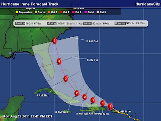
Again if you live in the 5 day Cone below, now might be a good time to support economic growth and go shopping in basics that are on sale this weekend somewhere at a Walgreens or Walmart near you!


Now is the time to make a plan. Party when the storm misses you but if it hits, you'll be glad you had a Plan A and a Plan B. Plan C of course is watching her fall apart of miss your town, but it's very possible that this storm is going to make landfall along the hurricane coast.

Besos Bobbi
Ps it looks like an eye above but the aircraft did not find one... yet, keep watching.

Saturday, August 20, 2011

11PM Tropical Storm Irene


I thought this was relevant and important out of the discussion this evening.

"GIVEN THE LARGE SPREAD IN THE GUIDANCE...THIS IS
A GOOD TIME TO REMIND USERS THAT THE AVERAGE DAY 4 AND 5 NHC TRACK
FORECAST ERRORS ARE 200 TO 250 MILES."

So, no matter where you are in the cone or along the SE/Gulf Coast... pay attention.

Again..Sunday is a good day to go over your hurricane supplies and buy what you need, just in case... Besos Bobbi

Bye Bye Harvey, Hello Tropical Storm Irene... Headed Towards Florida

Track:


Storm:


Harvey made landfall today over Belize and is yesterday's news. Don't get me wrong it's going to affect Central America, even as a weak Tropical Storm, it will do damage with mudslides and rain. It could even emerge back over water, but for now we have bigger problems.

However, the new storm on the block Tropical Storm Irene is not expected to remain a Tropical Storm long and it is forecast to head towards the Florida peninsular, most specifically for now the Miami area. This will change a bit, back and forth to the left and the right as Irene strengthens and the newer models come back with better data.

To be clear, this is NOT a matter of hyping a storm. The next forecast or two should show a much stronger hurricane than previously mentioned. Her inner core is intense for a Tropical Storm and if she maintains that convection and her pressure drops this will be a whole new ballgame for 2011. Tonight, the Prime Time Season begin and it would be best to look at Irene as a different entity than the last set of weak tropical storms.

That was then, this is now. The new model data and satellite imagery show a strong Hurricane moving towards the general Miami area or somewhere between the Upper Keys and Ft. Lauderdale and the Palm Beaches.


Since tomorrow is Sunday, I suggest people who are out shopping take advantage of the sales on school snacks and stock up on batteries, crayons for kids (they are really cheap now with school supplies on sale) and anything you might need to get through at least 3 days without electric. If Irene goes through the Straits and or falls apart over the Dominican Republic you can use it for Jose or Katia or donate them to some agency who collects school supplies and food for the homeless.

Again, it is foolish to think that God created Haiti & the Dominican Republic to be a windbreak for Florida. The water in the Southern Bahamas and close to the Florida Coastline is the warmest I've seen all year and it's only getting warmer. Strong storms survive a brush with land better than weakly formed storms. Each storm is different. I could wax poetic on Donna, Cleo, Hugo or Georges but the truth is this storm's name is Irene. Deal with it.

Pay attention.
Stock up.
Make lists.
Watch the local news, not everything is hype.
Yes, it's over 1,800 miles away but it's coming this way.
The models have been extremely consistent with this track, tho that can change.
So, pay attention and enjoy tomorrow because who knows what next weekend will look like?

http://www.wsvn.com/video/player/?clipId=6173015&clipFormat=flv&top
VideoCatNo=88645#?autoStart#?autoStart

Sweet Tropical Dreams and no I am not singing Goodnight Irene as it will be a long time before we say goodnight and goodbye to this storm.

Bobbi


Friday, August 19, 2011

Tropical Depression 8...9 and 10


Tropical Depression 8 is about as weak as it gets and is about to move into Central American/Southern Mexico as a weak depression, possibly a weak Tropical Storm. Really hoping the H name gets saved for a real Hurricane. H for Hurricane. Haha, get it.

Okay, am getting ready to travel now and just wanted to catch up here fast.

8 formed in the Caribbean, but from my perspective the wave out by the Cape Verde Islands is probably more of a Tropical Depression than 8 is currently however it has no designation just high odds of becoming tropical trouble.

So, that should be 9 unless they go in chronological order and make the wave in the Atlantic 9 in which case the REAL wave is 10. They will probably wait, most of the waves out there so far this year have fallen apart ... a victim to dry air. The models LOVE this wave and take it all the way across the Atlantic, however the NHC will most likely wait to see it show what it can do before christening it with designation status.


In the Mid Atlantic, near the islands is a wave trying to huff and puff itself together. Time will tell.

For now... still in waiting mode, but each new wave off of Africa looks better and better.

As for me, danced half the night at least in Crown Heights at a wedding and learned a lot about myself in the process. Life is a learning process, you keep learning things about yourself that others see easily however you are the last to see yourself. Truth is always obvious, sometimes we don't want to deal with it... other times we do. A wonderful wedding, danced with this family before and it's always fun and glorious. Right now it would seem the reason God made Shabbos is to rest up after a Thursday night wedding :) That's a joke. Don't you love it when you have happy music still in your head and you still feel like dancing??

As for me, back on the road today and hoping to have something more substantial to write about Saturday night. Back in Miami on Sunday. Bring on the tropical weather.

Good Shabbos... Besos Bobbi
Ps Basil in Crown Heights serves really good Espresso :)