A writer and a tropical muse. A funky Lubavitcher who enjoys watching the weather, hurricanes, listening to music while enjoying life with a sense of humor and trying to make sense of it all!
Wednesday, July 31, 2024
Wave Complex at 60% Orange - Just Needs a Center... NHC Tracking Carefully. Models Offer Mixed Solutions. Why? What Could Happen.........???
Some clarification here....
The arrow is not the PATH of the wave.
The arrow shows you WHERE it'll develop.
It's not a cone, it's not the track.
Forecast from NOAA for Saturday.
A weak Low is offshore Florida.
Sliding along the W edge of the High.
on Mike's Weather Page...
a different 72 hour forecast in this map.
Also from NOAA
Shows the Highs very close together.
Little broken line (wave?) in The Bahamas
A Low down in SW Carib.
There is no cone or forecast track.
So we look to other indicators from NOAA.
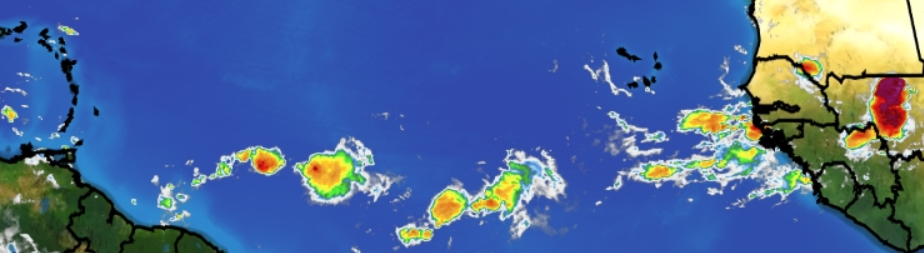
Below is the IR loop.
Wave Complex on right edge.
White ghostly cane is an ULL
Currently it's gonna keep tugging it West.
Also because it's weak and weak goes West.
Bottom edge of AOI is IN Carib.
More on that later.
Our wave complex could slide partly into the Caribbean, crawl across the Greater Antiles and emerge in the Florida Straits as a contender. This is basically the solution the GFS has stuck with through out it's runs. The EURO slides it up into the The Bahamas towards Florida. The orange grid is the FORMATION ZONE and the arrow kind of reminds you it's not forming by the X but in that hatched orange zone.
This is more a Wave Complex than a tropical wave. There was a tropical wave, behind it was a fast moving larger tropical wave that was interacting with a fast moving upper/middle level low caught in the Saharan Dust giving us thos picturesque images early on that we shared on Twitter aka X. Now it's a wave complex vs a well defined wave, and this is why it's less defined than you'd normally expect. I posted the image below 2 mornings ago on X and it showed something odd was happening with the wave which was really two waves and a complicated low caught in the Saharan Dust.
If you were watching carefully.
Our wave suddenly lunged to the NW on imagery.
Not a very fluid motion.
It was less movement.
More merging together of the forces at play.
When a wave is not alligned and just a wave or in this case a wave complex, it gets complicated as often models choose different pieces of energy within the complex and run with the ball in different directions. And, it takes a long, long time to develop. Hurricane Betsy in 1965 had a very slow, messy evolution until one area won out over the other.
A good case could be made that the actual wave is now IN the Caribbean and at some point the GFS and the EURO will merge together on one solution when a circulation forms and then runs with that ball towards whichever part of the End Zone it favors the most. And, as in football the waves do just that, like the Quaterback that searches for the area that has the least protection, throws the ball and the receiver grabs it and hauls ass towards the part of the End Zone where it can get the ball across the line and score. If the defense is too strong, doing it's job the other teams offense cannot get yardage and bogs down not able to convert and pick up downs. This is where we are currently with "The Wave" which is really a wave complex, messy and no real there there...yet. And, as it hasn't formed, energy can shift back and forth and all around like some glitzy old play a college team usually does to fool the defense and well we just don't know yet what the score is here or even where the actual center will set up.
True definition of "it's complicated" . . .
And, honestly it's easiest to say it'll move up towards the frontal boundary, but that frontal boundary isn't exactly hauling ass as it's July 31st and the fact that there is a frontal boundary at all is a big deal. Again this feels like late August not late July. And, that also confused models and people trying to track this wave. Stronger waves go to the right, weaker waves tend to drift to the left.
Normally, early waves stay weak and move West into Caribbean and then if they find a lucky spot they develop and pull North into the Caribbean, otherwise they move West towards Central America. Strong healthy waves pull North, but that works when there is a defined, strong low pressure area...seriously a center of a hurricane.
There is nothing normal about 2024.
Bottom Line
Outliers...
What could or is throwing a wrench into the forecast.
Stalling. Why might it stall?
August 1st fronts are not that strong yet and move slowly or stall. High to the left and high to the slide together and pinch off it's forward movement or escape path.
Could two systems form? Could both models be right? It's possible over time. It's a long, broad wave and sometimes a part of a system gets "left behind" and slides off westward with the flow and spins up somewhere else. The original, actual wave moves off towards the frontal boundary and traces the left edge of the high.
Why? The original wave we were watching, got eclipsed by the faster moving wave that was right behind it. When waves come off close together and the second wave moves faster they can do odd things and that is what happened with this wave. The NHC left the X in the middle of the whole mess, waiting to see what happens. IF it came off like Beryl, almost spinning with a well defined center, this would not be an issue.
Stay tuned.
I'll update if an Invest is put up later today.
Know there is a possibility of tropical weather edging up the Florida coastline and Georgia and Carolinas are all watching.
Know there is a possibility that the wave develops close in around the Florida Straits or in the Eastern Gulf of Mexico and moves towards landfall and both Georgia and the Carolinas need to watch that as well as often we get back door systems.
Sweet Tropical Dreams (or Fall Dreams if you wish)
BobbiStorm
@bobbistorm on Twitter
Twitter mostly weather, Insta whatever
Ps......Fall is when the hurricane season really ramps up and we get football as well ;)
60% Orange ....Watching & Waiting for the Wave to Get Into an Area More Favorable. Models Be Modeling. Stay Tuned..
We are holding at orange 60%
This is where we are today at Noon.
An X showing where the wave is....
An arrow showing where it's going.
It points to a formation zone.
THIS IS THE AREA.....
...WHERE DEVELOPMENT COULD FORM.
I'm breaking this down this way on purpose. There are two parts to this tropical problem that everyone is trying to over analyze, while models insist something forms close in and can get a name. One model makes it a serious hurricane, others make it a weak tropical storm, others show a long term threat to Texas and when we look at it we see not much to talk about. And, yet we are all talking. We are all hungry and dinner is delayed, but we can smell it cooking.
It's a broad area that is being watched.
Sometimes one model takes one part of it and carries it to one area whereas the other model takes another part and develops it elsewhere. The hatched orange area covers the models all sitting in opposite corners. The future is not clear, but we know where to look for something to develop.
What is clear is that twenty years ago there was not even an attempt to pick up on development this far out. Thirty years ago we were dealing with a weak, wandering westbound wave that became a tropical depression and then a weak storm named Andrew that was doing so poorly in real time that there was discussion about downgrading it but then something changed. There was no orange X before it formed with a long hatched period indicating it could be a threat to the Bahamas, Florida or the Carolinas in seven days before it was even designated. We are in new territory and people have to understand that.
I keep getting calls and messages from friends in Florida asking if they are going to get hit by the Storm. There is no storm, there is a weak tropical wave in an area that is unfavorable for development. But that weak, stubborn wave may get into an area favorable for development close in to Florida and the Bahamas. And, that is where we are today.
It's not a Cone.......... it's a ZONE ....an area where a tropical system may develop.
So we watch.... and good for the NHC that they are trying to give the most early info available to give a heads up that something may be forming. They are doing their job. Are you doing yours? Are you prepared for a tropical storm or a Category 2 Hurricane or a Cat 5?
I'll update when NHC puts up an Invest and we get a higher level of investigation of the situation.
And, remember models change all day, over and over and over so never stay locked in to some model that shows landfall 7 to 10 days away when we don't even have a "center" or anything but a tropical wave. But, know we are overdue for development and as we turn the calendar to August we will all see things ramp up tropically speaking.
If you click on the image below from ContentWeatherGuy who knows weather and has a way with words and carefully drawn arrows.
Orange 50% Formation Zone for Stubborn Tropical Wave Now Near the 50 Yard Line. Waiting on Invest and Recon to be Scheduled ...
50% Orange Formation Zone
While waiting for the NHC to put up an Invest. Let's look around the Internet.
This is plausible if ...
..timing and steering currents align.
Note this could get into this location in two different ways.
1. It slides up along the East Coast making everyone from Miami to Jax worry...
2. It can get further West, develop later and slide across the state of Florida then emerge
over the the Georgia Bight and follow the steering currents around the edge of the High Pressure.
Note moisture goes inland in the Carolinas out ahead of what would be Debby.
There's probably a third scenario, but let's stay with those two.
What I love about Mike (and this is going way, way back) when he says he has said all he can...he talks for another 20 minutes. Smiling. And, that's good cause I do so enjoy listening to Mike talk. Speaking of Mike, let's look at his post this morning.
We see a variety of possibilities*
So let's go back to the top 2.
It's possible the wave slides along towards the Island, lifts some (in theory stronger waves lift) and traces the High Pressure along the Florida Coastline. If the high expands then Florida is in play, if the High contracts it gracefully slides away. If the frontal boundary that has been forecast to possibly be there shows up it can move on up into Carolinas or slide off the coast with it near OBX. Again it's all about timing. If you are not at a bus stop the bus does not stop for you and you miss the bus.
It's possible that it slides more to the left (West) stays weaker, dumps heavy dangerous rains on the islands..both Lesser Antilles and Greater Antilles and curves up somewhere near Cuba (if the High is that HUGE) and begins to develop a core in the Florida Straits and slides up the SW... West Coast of Florida finding a spot to criss cross over. This happens usually in October, however the weather patterns have been unpredicatble and we've seen a few weak frontal boundaries move far to the South where they die out and where they do weather happens often. Then the system could slide back, re-emerge and slide up the coast. Yes, this does sound like some gymnastic routine you might watch if you are watching the Olympics thinking "how did they do that" and that could happen. Logically the first scenario makes more sense.
*It's all about where, when and why it forms and where the center is..how strong the center is and what it appears to do in real time and how it interacts with the High Pressure AND any Upper Level Low that shows up for the party. Basically it's complicated. It has not formed yet, it is simply a wave we are watching that has a good deal of model support and more troubling forms closer in being a problem where landfall is more assured vs some out to sea variety that turns North fast before the Islands becoming a Fish Storm.
Orange is moisture.
Rusty, reddish orange is moisture
As for the Sahran Dust, this wave has wandered West staying weak but there and now is at an area where there is actually ample moisture for it to flare up some and show us what it's got.
Again the steering currents are currently all about the High Pressure and the location and timing of the where the wave develops and what the High is doing as to what me as the steering currents usually dictate the actual track of what could become Debby.
Personally waiting on it becoming an Invest, as that raises up the level of investigation, data and info we get from the models, satellite imagery and the ever popular floater. I'll update if they do.
If you live in the area of Florida, Cuba, Bahamas, Islands and North up the coast to Georgia and the Carolinas you should be watching this to see how it unfolds. If you go to the store today, tomorrow or the day after grab something you have been meaning to buy to throw in the Hurricane Supplies and go about enjoying your day. In a few days we will know more about what may happen and less about every possibility a random model throws at us on any given run.
Have a great day... stay tuned.
Sweet Tropical Dreams,
BobbiStorm
@bobbistorm on Twitter
Twitter mostly weather...Insta whatever.
No plans to go to MIA personally.
But who knows???
You should follow them if you don't already.
Good at drawing wxr maps and music.
Suggested I'd like it and they are right!
Things to remember:
Weak systems are prone to produce copious amounts of rain and anywhere there is elevation, you can get dangerous flash flooding in Hispaniola and Puerto Rico.
Sunday Morning in the Tropics. 40% Orange - Lots of Talk and Not Lots of Action. Chasing Models on Tropical Waves. We are in the realm of IF and IF and IF = ???
40 % in 7 Days
This is NOT a Cone but a Zone for formation.
While the cone often is laid over these areas we see in the early days of wave watching, it just as often doesn't happen as it evolves over times as the models try to grasp onto a slippery solution while a wave tries to find some traction and develop. We are in the realm of IF and IF and IF = ???
Not using names, just showing images.
I will say below is the GFS - go figure
Fact vs Fiction.
What is real today?
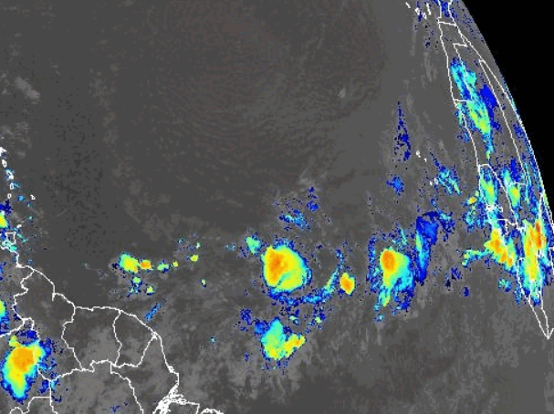
Cute li'l Low with no name.
That's a current image. As in really there.
Content Weather watching it because...
..it's up in his backyard.
And it EXISTS it's not a model suggestion and it hooks in towards him!
And he does so love his yard..
Below is not the same low.
This is a next week from the EURO
.
So while the current low off the coast is not being watched by the NHC so it's irrelevant, but may cause a li'l bit of damage in parts of New England. Then...the EURO throws a bigger, improved low up that way in a week or so. It's worth saying that the EURO fantasy low goes out to sea sliding up along the coast as far as it can go.
Patterns are important.
But what I am really showing you in the above squares of nameless models and that one reformed GFS one is that.........they all are reading the High differently. The first one shows the High suddenly contracts, inhales and allows a system to slide on by. Let's look again.
The next nameless model shown above doesn't allow development until the last moment, after laying low and playing possum and suddenly showing life after inhaling good Cuban Coffee and slides along a weakness in the ridge (high) and threatens the Gulf of Mexico.
The usual GFS BRAT who likes to party hardy no matter what the other models will do suddenly goes rogue and refuses to see any development, anywhere in the tropics. Go figure.
And perhaps the GFS is right?
Or not...........
The GFS shows a high of epic proportions.
Yes, I showed that 3 times.
So until we see real development from a tropical wave we are just shooting the tropical breeze with lots of hot air that probably reinforces the ridge.....hey .....who knows....maybe how the High gets so huge and really I don't know. Lots of run on sentences while grappling for something hard to grab onto here.
Yes we have waves. Yes we have a "formation zone" of 40% orange. Only wiggly, circular lines on Earthnull where the only closed low is the aforementioned "no name low" off the East Coast. What we see from satellite imagery is a stubborn wave that survived the SAL and is just about at the 50 yardline. Oh my gosh I miss football!!
Fact vs Fiction.
For now we are playing Fantasy Forecasts.....
....makes a good meteorological mystery novel.
Fact is nothing definitive is going on.
But yes, it is fun to speculate online.
So stay tuned.
35 days til September.
August should drop a storm or two.
Time will tell.
Sweet Tropical Dreams
BobbiStorm
@Bobbistorm on Twitter
Twitter mostly weather
Instagram whatever
It's a summer day in Raleigh. That means it will get hot eventually, even if I have the window open with a fan in it pretending I'm back in California and not in Carolina. There's some numerological game going on there if you are into that and oddly it's one of the more out there things I am not so into. But I notice the peculiar fact that I left Florida for California, went back to Florida and then left it again for Carolina. Is that weird or what? I do have to say that I've been to many of the 50 states (and PR) and Florida, California and Carolina all have a whole lot of beauty. As I got older the realization hit me that most of the got away hurricanes passed Florida by for the Carolinas so when I met my soon to be husband from Raleigh and we were dating I thought "Okay.... Carolina has football, Carolina gets hurricanes and they get snow" and so luckily as things worked out I'm here in Carolina waiting for some cooler temperatures, fall weather and looking to go to Wrightsville to throw kisses at passing by hurricanes that clip the coast and move on elsewhere while serving up some awesome waves. Sometimes they make landfall here. Often they make landfall here. Is this Florida's year for landfalls? Honey child, as my Grandma Mary would say, "we just don't know yet what's gonna happen" and then she would go walk the dog and stare up at the clouds with a nervous look because she grew up in Tampa and she knew weather. She read the clouds, the patterns up above in the sky the way we sit and stare obsessively at models.
Much love...thanks for reading along... stay tuned!
Saturday Night.... Orange in the 7 Day. Just a Moment in Time.
That's basically the gist of it.
Note the placement of the yellow X
I say that as the wave behind it steals attn.
Again it's the lead wave.
Not the one with the long tail.
Nor the one that has yet to come off.
Bottom line, this is a healthy wave train despite the Saharan Dust and as we get closer into August something will ignite other than wild fires out West. We have smoke in the Carolinas from the fires in California today apparenty.
I'll talk models tomorrow. Just putting this here and noting that the yellow circle has been upgraded to orange.
I've said numerous times we are running ahead of schedule a good 3 weeks at least. Normally late August the real season begins when waves are healthy, vigorous and viable. In about 4 days it's August.
2 PM Update! Unstuck 20% YELLOW CIRCLE in ATL ---------Which is More Stuck? 2024 Hurricane Season or Astronauts on the Boeing Starliner? Just Wondering...... State of the Tropics July 26th! Curiously Countng Days as Models Tease Us With Different Storms Every Day... Yet Nothing is Happening. But We Got a Great Wave Train Going So.... Eventually We Will Get to the Debby Storm
And just like that!!
Everyone on X posts at the same time.
It's a long way off.
The cone can change depending on motion.
After it's formed.... just an X right now.
Zero in the next 2 days.
Look at that... has a little curve to it.
Rudimentary left hook!!
It's a complex wave....
...give it time.
It survived the SAL
Stayed alive....
Please keep reading if you haven't done so...
***
7 AM
I'm beginning to know how they feel.
Not really.... but kind of sort of.
So they went up there for 8 days and have been stuck in space going on 50 days, depending when you read this blog. It's been 55 days since the much balleyhooed 2024 Hurricane Season began amid clickbait articles, beautifully done segments on weather shows and headlines in the old school newspapers. No, we do not get them anymore, but I do stand at the market and stare wondering why anyone would want me to spend $6 for a thinned down version of the newspaper that barely would wrap any fish caught at the pier in Wrightsville. But I do look to see what the headlines are and what they felt was important to put on the front page. Spoiler Alert, I studied Journalism for my degree in English and so.... I'm always a little curious what's selling in the world of newspapers.
We did have Beryl and that was a whole lotta of hurricane excitement condensed into a short period of time, and it'll take YEARS for the islands originally hit by that extreme Cat 5 energy to recover, rebuild and get back to any sense of normal.
I'm sure the first few days on board the Boeing Starliner were exciting and then suddenly everything changed.
If you are still reading this, know this is true in life often. Something, suddenly happens or changes and it changes everything totally. The same way we keep saying "when someone flicks the switch" on the Hurricane Season.......... And, that is true too!
During Beryl's advancing track towards the Islands, as it inched along looking as if it would survive as I thought it would I'd wake up at 6 AM and grab my phone half asleep to check on how it was doing. It way exceeded my expectations. It exceeded everyone's expectations.
Most meteorology people who study the atmosphere on Planet Earth have a quiet fascination with astronomy and geology and unless there's a press confernce explaining that they haven't found a way to "safely" bring them back yet and they aren't really stuck....because they have calculated they have enough time up there to figure out a repair and ......... the story gets buried behind the very fast moving river of news that has raged the last few weeks. That is a long run on sentence, much like their unexpected space trip that over produced how many days they'd be up there in their Starliner.
It's been 55 days since June 1st and we are now stuck in the doldrums of "nothing happening for 7 days. I have food, way too much food in the house and lots to drink so really I'm okay. I have awesome AC thankfully. I have a plethora of things to do as I wait this period out and a myriad of models promising landfalls up and down the coastline if only one of the waves would develop and does what one of the models suggest it could do IF it develops.
Something will develop.
Something wicked this way will come.........
So let's look at the tropics and take it apart in real time this morning, in reality without looking at models that often promise what they take away the next day.
Nice Center Grid from Spaghetti Models.
Up on top.... you will see a very, colorful and bright ITCZ as tropical waves leave Africa hot and heavy, excited to begin their journey. And, then they begin to peter out (my apologies to Peter) and they limp along hoping to find a way to keep on going. Truth is with every week that passes by, things are looking way better for those waves than those astronauts. Time is on their side and eventually one of them will spark up and twist and turn and everyone will be more exctited about what's on the satellite imagery than what's on the ensemble models. That said many will still live and die by the models. Note to the North of the waves is darkness, like black as the pit from pole to pole in a way that even William Earnest Henley could never imagined! You can Google that if you wish. Note over near Central America there's a flurry of convection.
On the bottom grid you will see we are back to that diagonal look on satellite imagery. Everything runs from SW to NE as it did a while back before Beryl and before the astronauts were launched into space on their beautiful Starliner. Remember this is why Beryl did not limp into the borderlands of Tex/Mex and was lifted up along the Texas border creating flooding in Houston, tornadoes further inland and flooding storms even further inland along that path that many pointed out looked similar to the eclipse path. Again, many meteorologists are obsessed with astronomy also.
Not alluding to anything mystical or magical here.
Just when you're hot your hot?
Sorry... being a bit silly.
Again patterns.
Always important to watch patterns.
Current Mimic is pressing down again...
...showing the High trying to set up again.
Can it? Will it?
Moisture has been the name of the game..
..in the South.
Almost like Mason Dixie Line there.
Gulf of Mexico Juicy.
Down near Central America JUICY.
Bahamas juicy ..ready and waiting.
ITCZ is a solid colorful line, looking fine.
Just nothing has sparked just yet.
Models perking up again.
In a week or so... should see something.
Something could be an Invest...
..not predicting the return of Beryl.
Stay tuned.
If the NHC takes their crayons out I'll post something. Otherwise, unless I'm in the mood to write I'll probably take the weekend off. But, who knows with me as I'm moody and restless. Good mood, playful but definitely restless. Probably not as restless and moody as the astronauts "not stuck" up there according to NASA and waiting, while the river of news runs restlessly along every day like a raging river.
Bud Forms in EPAC - Count 7 - 10 Days For Development in Atlantic Basin. Ensemble Models Jiggly and Fun to Watch. End of July into August 1st...Watch Out. Did Ya Ever Play Pinball??
NHC says nothing for 7 days.
Bud formed in the EPAC
Count 7 to 10 days for the ATL
Are you watching the new wave?
Are you watching off the SE coast?
Are you staring at the Gulf of Mexico?
Who are you?
Where are you?
What do you really, really want??
Good to see Thor making a video.
Watched while looping the WV loop.
That's just a tease, don't click.
Link below.
Remember Ensemble Models is like trying to read tea leaves ...some swear by it.
Regular models aren't often as much fun but more definitive. Breakfast Tea.
Ensembles aren't showing you "tracks" they are showing you possible different locations where something may form and then where it travels. Follow the bouncing ball. And, often ensemble models sniff out the pattern like a really good Cocker Spaniel or Golden Retriever.
I kind of wrote the ending to this blog, before I started which is odd for me. I often go with the flow and yet when there's nothing definitive to say it's best to be honest. I also had weird dreams when I was waking up this morning, but I digress and yet it explains a lot.
Ensemble models are fun. They always remind me of pinball machines and there was a time I could take a break and play pin ball for hours, in high platform heels beating the ass off of an odd collection of guys who would freak in awe how I did that. Honestly, I told them it was the heels, they gave me the edge. Barefoot I couldn't get the right angle nor jiggle the machine just enough for it not to tilt and yet get the ball to do what I wanted it to... I could play for hours for free and yes I did.
When we look at models, especially ensemble models everyone sees what they want to see and if you try too hard it tilts and game over for you, though someone else might get a storm. You can't force it to form and where it forms matters and when it forms matters and that's why one of those tracks may verify perfectly while the others are out of the game. Then it's a marble shot off into a pattern that is set up for the machine to usually win, though sometimes you can beat the machine!
This is that time of heartbreak for hurricane trackers who want desperately to track and perhaps chase and models are not totally reliable, Saharan Dust is bothering everyone's eyes and doing way worse to the beautiful little tropical waves, bouncing along westbound trying to get somewhere while SAL sucks the moisture out of them if they are too high. Note Beryl was low, stayed low. Late July waves are usually higher and the new wave is coming off at X marks the spot latitude wise to be a contender!
I do think it's most likely going to go lower than most suspect, unless the energy splits as sometimes happens and part of it moves up towards Bahamas and another part sneaks into the Caribbean sliding by the Yucatan it suddenly gets noticed and whoah Gulf of Mexico!
This time of year if you want to place a bet.... bet on something coming alive just before the Islands. If you like a long shot, go for "hurricane off Florida coast" or "another GOM landfall!!" but in the end that's a recipe for click bait and heartbreak.
But oh that new wave looks good. My concern is ...it has a friend and the friend really, really likes it and the friend behind it is moving faster than the bigger lumbering wave. So do they collide, combine or create an imbalance of energy and we have to watch to see which wave wins?
You can see here the 2 waves and SAL.
The Beryl Kick Ass Wave....
..was sneaky early & stayed low.
This region above is begging for a system.
Tropical system.
TD? TS? Cane?
When, not sure but it will get one.
Often while we stare at waves off of Africa, something closer in is trying to form from remnant leftovers from an old wave, a stalled frontal boundary and an over active sneaky Upper Level Low that all collide and make one hell of a tropical dish. You want to watch a Trailer for a movie or the real movie? Sometimes trailers are better. You want to see highlights of a speech or do you want to watch the speech? Never trust Memes they are funny but...
Dabuh, my buddy, likes to say Fork in the road.
In truth sometimes....
..a wave can take both paths in da tropical woods.
Evolution of Weather Patterns. Atlantic Closer to Possible Development. Juicier! Good Waves.... No Yellow Circles Yet... But Soon. August 8 Days Away...
This graphic shows candy strip red ... ..where tropical waves will lift WNW But weather happens in real time. Models infer waves get further West.
And yet nothing really happening
Graphic of the day. NHC says nada in 7 days Nothing... well there is something to watch. Tropical Waves rolling Westbound.... ...then lifting according to models.
Nothing developing now. Just waves.... our purple splotch map shows it better. Hightlighting the heartbeats of the waves.
It's not one blotch....
Inter Tropical Convergence Zone.
As the SAL dries up....
....the atmosphere moistens up.
Then BOOM!
BOOM BOOM BOOM!!!
Soon...........
Have you made a Hurricane Plan??
If not...why not?
If you live in Hurricane Country...
....get a plan, a good plan!
So let's look at the wave train.
Darkness before sunrise above.
Actually prefer that view....
less distractions.
After sunrise below.
After darkness comes sunlight!
Gray/silver dots are Saharan Dust.
Waves below today.....
...will be hurricanes next month!
8 days til August!
In motion...does something catch your attention?
Waves get better in real time.
Day by day...
we are on the way
to August!
There's not much to say....other than things are rearranging, bit by bit in the atmospheric patterns across the planet. Everything is connected, related and interconnected when it comes to weather. Nothing develops in a vacuum. It's more about the set up than it is how great looking a wave is, because if the set up is not there to support it then it doesn't develop. If there's shear it slams the good looking tropical wave and knocks the tops of the thunderstorms off and no hurricane.
So stay tuned. Use this time wisely, if you see things on sale that would be good for hurricane supplies throw then in your cart and hide them away somewhere. Like a hurricane treasure chest!
Location: Miami, Raleigh, Crown Heights, Florida, United States
Weather Historian. Studied meteorology and geography at FIU. Been quoted in Wall Street Journal, Washington Post & everywhere else... Lecturer, stormchaser, writer, dancer. If it's tropical it's topical ... covering the weather & musing on life. Follow me on Twitter @ https://twitter.com/#!/BobbiStorm


.gif)


.gif)

.gif)


.gif)


