Hurricane Harbor

A writer and a tropical muse. A funky Lubavitcher who enjoys watching the weather, hurricanes, listening to music while enjoying life with a sense of humor and trying to make sense of it all!

Wednesday, August 31, 2016

11 PM Update 60 MPH .. Barometer dropping .Hurricane Warnings Up


10:00 PM CDT Wed Aug 31
Location: 25.8°N 87.0°W
Moving: NNE at 10 mph
Min pressure: 998 mb
Max sustained: 60 mph

rbtop_lalo-animated.gif (720×480)

To some this seems confusing.
To others it makes sense.
Just look at the top of the blobs
The center is to the left of it.
Shear coming in from the West is pushing weather East.
Even if it's moving NNE at 10 mph..
The WEATHER is moving East.


Look how much weather Tampa Bay is already getting.

3 Day 


Let's focus on the 3 day.

wv-animated.gif (720×480)

If you see the loop above.
You can see the sharp dry line angled NE
The front moving down ... and over to the right.
Hmnnn. Bugs me.
Long flow of convection ...
...sort of 8:30 to 2:30 direction wise.
The system slides up between the two.
It follows the track.
It might not look pretty but it is what it is.


If you live in the end part of the cone.
Do not panic just monitor the storm.
Watch that the NHC does not pull it further East.
Travels FAST from GA/SC line to VA/NC line.

Sorry for any typos.
Been a long time.
Will update in AM with morning visibles.
And the next cone.

If you live anywhere from Pensacola to Tampa..
In my opinion watch it carefully.
The next six hours will tell the tail for Jax.

Tornadoes could be a big problem.
Hurricane Warnings up.
So NHC believes it could become a hurricane.
They are playing it conservative. 
IF it's 60 mph tonight.
Barometric pressure dropping.
Could be a Hurricane.

Sweet Tropical Dreams.
BobbiStorm
@bobbistorm on Twitter

Ps Watches warnings.


Thanks Mike @tropicalupdate
He drew it live on Facebook Live.
So redundant haha. Nite.


Hermine Track Pulled West at 5 PM. Check Back Every 6 Hours. From FL to NE .. Capital Cities Inland All in 5 Day Track.

5 PM 


I know everyone wants to talk about the Cone.
3 Day most reliable.
Takes it from Gulf of Mexico to NC VA Line.
Nearing the Chesapeake.

Then it slows down and stalls a bit off shore NJ ..
...South of NY as a weather maker.
Not so much a Hurricane or TS but weather maker.
Actually the map shows a S designating a Storm.

I'm going to call this the Capital Express Storm.

Tallahassee near land fall
Georgia ..some rain near Atlanta maybe.
Columbia SC
Raleigh NC 
Richmond VA

The Amtrak Silver Star should have problems.
Takes an inland path...
Silver Meteor for that matter too
Airports in those cities and near by will be impacted.
Check if you are traveling.

This really is a huge mess if the track verifies.

http://www.nhc.noaa.gov/text/refresh/MIAPWSAT4+shtml/312049.shtml?

Check your city for wind probs.

I'm at 50 for now.


You can see that inland track NHC forecast.

What I like about him is he's unique, does a good job.

Shows difference from old NHC map.


So I'm using Raleigh as an example in the middle.
But this is the same for many places.
That's a big change in track.

Is it right?
Will it verify?

I'll feel better tomorrow at this time if it's following the track.
So far Hermine has not been a team player.


This is the map of the area most likely to be affected by landfall.
BUT... most of N and W Florida will be affected by weather.


See how they overlay.

I've always thought it would be hard this time of year..
...to make such a hard right turn.
Apalachicola area most logical.
Weather will be bad EAST of landfall!!

I want to look back a bit.


The 40% big wave is early Hermine.
It was a huge wave coming off of Africa.
Contracted under SAL's influence.
Refused to give up ....
..now that it's intensifying its becoming big again.
I said days ago this had a classic Cape Verde look.

Don't look at the center or appearance.
Look at the RAIN SHIELD


Just think how much moisture there is here.

rb-animated.gif (720×480)

It's not just about storm surge at the beach that the "eye" crosses.
It's about the whole kit and kaboodle 
(Did I spell that right)
It's the whole shebang.

This is a 5 course meal:

Surf
Rain
Wind
Tornadoes
Power Outages possible.

And it's going to affect many metropolitan areas..
IF the track and forecast verify.

Why do I emphasize this?
Because rarely has it ever followed a track exactly.
And at some point the cold front comes down..
..weakens..
Steering currents may collapse a bit.
And that may happen up South of Long Island.
It could be extratropical ...
It could just be weather.
But "just weather" created flooding along the GOM.
Will it stall when NHC says...
...or earlier off VA or Del Marva?

Just keep watching.

IF Hermine doesn't follow the program.
The NHC will pull the track to the left or right.

Their discussion?

Salient points highlighted


And note their Intensity forecast

Read through that and see the shaded area.

What do you do if you are in Day 2 or Day 3 ?
Day 4 or Day 5?

Wes in Raleigh just told his viewers ...
...to remember to check on the storm every 6 hours.
Every 6 hours the NHC updates their cone.
It's that simple folks.

sat_wv_east_loop-12.gif (640×512)

You can see the dry air.
You can see the SW to NE line that Hermine will follow.
You can see the front digging down.

Keep watching.

Please follow your local advice.
The local mets and NWS know your unique problems.

Valdosta, GA has it's problems.
N Florida and Georgia have many big oak trees.
Hardwood trees snap and come down.
Palm trees bend, hardwoods break.
Especially if the ground is wet in advance of the wind.
They come down on cars, houses and people.
That can be and often is deadly.
Being deadly serious.
Find a safe spot inside the house during the storm.

Areas along the coast have coastal flooding.
Sandbags or whatever you need to do to protect your home.

When trees go down power goes out.

Tornadoes can be a problem in this storm.
Up the coast along I 95 ...
...if you plan to travel rethink it..

This site covers the highways.
It's an interesting site but it's good for travelers.

http://www.bridalweather.com/

This storm could track up I-95
Small roads, all roads.

Every person reading this has their own needs.

Pets... 
Children...
Older relatives...
Some live in a house and others apartments.

This track by the NHC covers so many people.
Each person has their own unique needs.

My advice:
Make a list of what are YOUR priorities.
Focus on them.
Get money out of an ATM.
Get any meds you need.
Get some food and things to stay home.
Hunker down. 
Watch TWC.
Listen to the radio if cable goes out (got batteries?)

Do what you got to do.

I'll be back later with any updates.

Hermine is forecast to move 7 mph.
Will it move 7 mph?

ft-animated.gif (720×480)

Stay tuned.

First thing we will see is rain.
So going to leave this song here.


We can focus on the African Wave when it looks viable.
www.spaghettimodels.com
www.tropicaltidbits.com
www.hurricanecity.com
www.crownweather.com
http://dabuh.com/ (surf reports)

Besos BobbiStorm
@bobbistorm on Twitter ... I'm there all the time.. 

Ps Check for Live Feeds from Mike's Weather Page.
https://www.facebook.com/mikesweatherpage/?fref=ts
He does them randomly.
He posts them on Twitter.
He's developing a close community of fans.
And the fans interact in comments in real time.
Very 2016... 


Tropical Storm Hermine. Please Use NWS For YOUR Local Area As Well as NHC. Take it 1 Day At A Time in 4th 5th Day of Cone Please.


Officially Hermine

Visible loop below:

vis_lalo-animated.gif (720×480)

Wider View:

rb-animated.gif (720×480)

Track:


Note the problem with NE bound GOM systems is...
... the rain is far out ahead of the center.


Going to update later with more information.

Nothing much has changed other than it has a name.
A much deserved name.


Look at that blow up in the GOM.
Also note convection up near Carolinas now..

Storm Surge:


NOTE.. WARNING..
This shows landfall storm surge. 
Follow NWS for local coverage in N Florida.
Example.. this exits by Jacksonville...
...they need to prepare as well.


NWS is incredible.
Tallahassee, Savannah, Ocala.

www.weather.gov
They have YOU covered.
But you got to go to them and see what they say.
NHC is great. 
NWS covers local problems.
Use them please!


http://www.srh.noaa.gov/media/jax/briefings/nws-jax-briefing.pdf


1st concern:

Florida:
Torcon of 7 with high chances of Twisters.
Flooding up and down both sides of FL coast.
Heavy rains over low lying areas.
Many parts of W Florida are bayous, swamps.
Bays, beaches all low lying.
Wind damage dependent upon eventual intensity.

2nd concern:

Georgia and Carolinas.
All depends on eventual track Hermine takes.
Further off shore less of a flooding problem.
Further West and there could be inland flooding.
Appalachian mountains add in rain totals.
Hilly areas down stream prone to flooding.
I'm mildly concerned it could slow down or stall.
Not in forecast but it hasn't been good at following forecast.

3rd concern:
Virginia .. NORTH
Again dependent on track it takes...
Do not panic and avoid hype on NY NJ NE scenarios.
Let's deal with Florida first.
After seeing what it does the next 2 days will tell the tale.

It's only going 2 mph now after a long stall.
This forecast is reliant upon getting the timing right.

Intensity forecasting is not perfect.


The white 3 day track is generally right.
The 5 day shaded track is a strong maybe.
Note it's wide on the 5th day.
That's a wide, wide cone so take it one day at a time.

Again if it goes slower than expected.
It could miss it's ticket out of town... 
Watch forward speed with Hermine.

I'll be back later with more model discussion.
If you CURRENTLY have watches or warnings.
Please take them seriously.
Do what you got to do.
Sandbags, food, medication, batteries, first aid.
Crayons for kids.. new toys.
IF the forecast is correct Hermine will move faster.

Keep watching.

Besos BobbiStorm
@bobbistorm on Twitter


TD 9 Meandering ..Consolidating. Watches, Warnings UP.


ft-animated.gif (720×480)

From far away Tampa Bay is getting slammed this morning.
Banding forming along the SW coast of Florida.
Pumping, evacuating energy well.
Can it maintain this development?
Funky green this morning on Funktop.
That's what it's called.
I didn't make it up!

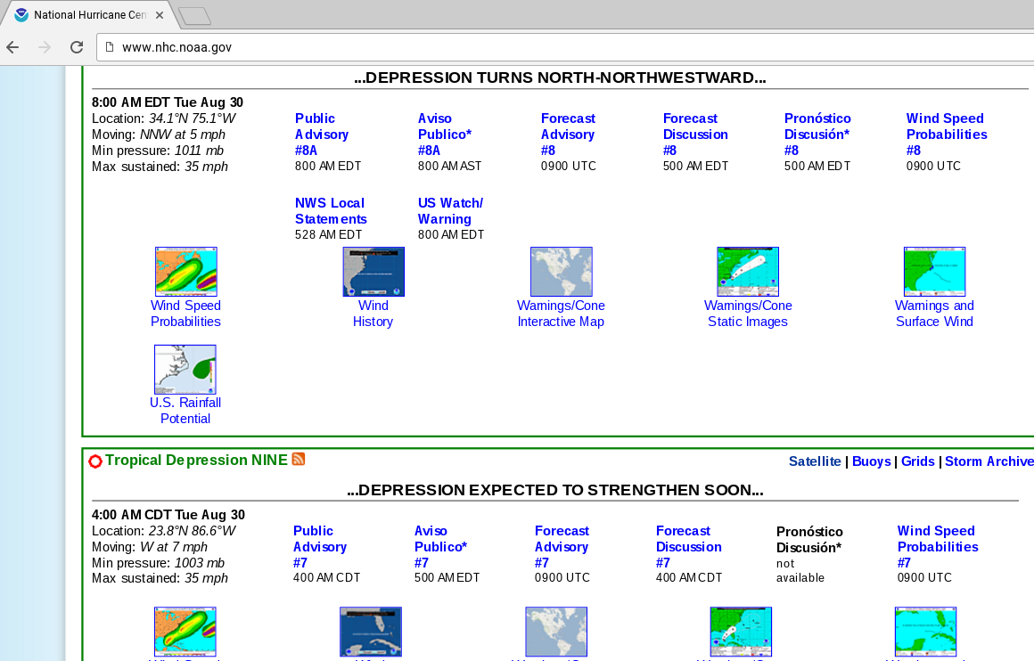
TD 9 has slowly meandered into the Gulf of Mexico.
NHC used the word "meandering" so quoting them.
Temporarily steering currents pretty much collapsed.
That is forecast to change.
Pay attention to the NHC watches and warnings.
But remember TD 9 has not been a team player.
Moves slower and usually to the left of forecast.
At some point.............
.....it will get picked up by a front.

Below is TD 9 up close.

ft_lalo-animated.gif (720×480)

Our storm of the hour. 
TD 9
Waiting on upgrade to Tropical Storm.
Tropical Storm Watches and Warnings are already posted.


Personally believe it will come in left of the cone.
Weather will be everywhere especially on the right side.
High tides on the right of landfall.
Worried up the coast on inland flooding.
More on that later today


I show this to keep in perspective the rest of the tropics.
Hurricane Gaston with a large eye.
They say you could fit the state of Connecticut inside it's eye.

That's an eye of a hurricane!

ft_lalo-animated.gif (720×480)

Sticking here with the same loop.
That's bizarrely beautiful.
Compelling. Mesmerizing.

Okay got more to say today so will stare later.

A little frustrating to watch the painfully slow evolution of TD9 as it's hard to see continuity at times in upgrades. Joe Bastardi writes long on this, you can Google it. He's right in ways though he likes to rant on it and I won't. It's enough to say Colin was named and yet Colin looked worse than this system. Why? They said it met parameters. As I was not in the room when they made the decision .. can't argue that. But models were in love with Colin and last few years we have become very model driven. Example being the hoopla over Invest 92 as it rolled off the coast of Africa as models oohed and aahed about it getting a 50% orange circle before it hit the water. A mediocre wave I thought, yet there were dire warning of East Coast landfalls possible while over the Congo. Yesterday they quietly pulled the plug on it..for now. Yeah... okay... and they complain the local weather stations hype the storm? 


Compare and contrast to Tropical Depression 7


Colin with a misplaced center often.
Misplaced convection.
Models loved it.
Never lived up to models.

Hit the same general area so interesting compare and contrast.
It is typical for patterns to exist and have similar tracks in same year.

So it's a TD and it should be upgraded in an hour or less.
If not at 8 the package should be out at 11 AM.

Either way there are watches and warnings up.
They need to be taken seriously.
At some point steering currents will change.
It will move faster than a meander.


I'll be back later with an update.
I'll most likely be updating throughout the day.
Thanks for your patience yesterday.
I took the day off to play.
Sometimes you got to.
This slow motion 10 days worth of tracking...
"we are expecting conditions to improve" 
...has seemed like a month.

Went out with my husband to some event.
Dressed up, drank, laughed.
Had a BIG margarita!
Ignored the storm.
(except for looping on my phone ...)


Fun to have fun sometimes.
I had a really good night.
Expect to be busy next few online.
So thanks for your patience yesterday.. 


Cantore is having a really good morning.
By the beautiful Gulf of Mexico.
Going to compare and contrast different days.
So you can see how the water changes before a storm.


Again this storm is forecast to ride up the coast.
From one Southern city to off shore NE.

Jacksonsville, Savannah
Charleston, Wilmington


Check for your city in the link below.
Know those are minimal percentages.
When they hit 50% or more pay attention.

http://www.nhc.noaa.gov/text/refresh/MIAPWSAT4+shtml/310852.shtml

And this is forecast to possibly be a Hurricane.
Hard to believe but wouldn't bet against it.
It's come a long, long way to get here.

Besos BobbiStorm
@bobbistorm on Twitter where I live... lol

Ps Wondering how many Margaritavilles it can affect?


Fun place, one of my favorites!


Tuesday, August 30, 2016

UPDATED!! Watches May Be Posted Later Today For Florida. Cantore A Coffee Nut. Someone Get That Man Some M&Ms & NOTE TO NHC PLEASE UPGRADE A TD


Afternoon Update.


We are moving towards a Tropical Storm Watch.
Forecast for TD 9 is that it IS going to be a TS ...
eventually...........

This is why they are going to post watches.


The drone from the NHC did find tropical storm force winds.
Hasn't been upgraded they are evaluating their data.
Watching it on satellite imagery.

Tampa Bay Bucs changed their Thursday Game.


You don't do that unless you have good info.

And most of Florida along with Tampa Bay are watching.


Good news is that models are coming into agreement.


A kink in this set up might be a stall.
Or a loop.
Watch how strong the steering currents are down the road.

Also I'm worrying on tornadoes in it's path.

Storms like this at this angle to bring tornadoes often.


Josephine in 1996 brought a problem inland with Twisters.
Ocala, Gainesville and other inland cities could get TS weather.
Rain remains the big problem.
Again it's left sided so much of the coastline should be under the gun.
Under the gun for wicked weather.
Not HURRICANE FORCE CAT 2 winds..
Approaching Hurricane force maybe...
...if models nailed it.

ft_lalo-animated.gif (720×480)

We're not there yet Virginia and Carolina.
Close but no cigar as of 2 PM.

Will see.
I'll update later.
Keep reading..
Good discussion below:


My take on the models.


Front center stage Hurricane Gaston.
You see that one right?
Yeah.

Far to the left is an area of tropical weather near Texas.
Some how that got lost in the TD9 shuffle.
Convection of TD 9 down near the Yucatan.
It's center is the red dot further to the North.
Close to Carolina is a cluster of convection known as TD 8
THEY HAVE NOT BEEN UPGRADED AS OF 8 AM FROM NHC
And off of Africa is a huge, big new wave.

Those are our Atlantic suspects in the tropics.

In motion

sat_wv_east_loop-12.gif (640×512)

Front heading down to pick up Gaston.
That's the forecast.
The spin over Georgia is an ULL
ULL = Upper Level Low
It's forecast to draw TD 9 up to the NE
Lows follow lows.
Basic rule of meteorology.
Gaston may do a brief tour of the Azores.

Now let's look briefly at the Pacific

sat_wv_west_loop-12.gif (640×512)

Those are two cyclonic storms.
Hurricanes headed West 
Hawaii is in their way.
Hawaii is in the US of A so...
..USA is getting tropical trouble.

Continental US getting NADA right now.
Safe for now for Labor Day Weekend


Great wind map.
Link:

http://hint.fm/wind/
Use it.. play with it.
It was done by an art student who had to make a map.
She worked with meteorology, computer friends.
My son worked on it.
Not supposed to say that but ...oh well.
It's awesome in that after they made that.
Then every one made them but bigger.


Again don't need no hurricane hunters to find the hurricane.

TD 9 remains ELONGATED
TILTED
Weather will be on the East of this system.
So Tampa, Naples...
Every city along the West Coast of FL will get weather.
No matter where it makes landfall as a ???

Carolina Depression (my girl) is closed tighter.
There is some sense of the wave off of Africa.

Stay tuned.

This is where we are at...
..waiting on upgrade.


If you are a Tropical Depression 9 Junkie


All of us are in ways weather junkies whether we have a degree, multiple letters after our names or mentions in the Wall Street Journal and Washington Post like me. Whether we live on Hurricane City or eat a steady diet of Spaghetti Models we are all weather junkies. I woke up briefly at 5 AM looked down at my phone like someone who knows they shouldn't have that last beer.. my stomach got tight, I debated... I put it down in hopes that by ignoring it I'd wake up to another named storm. Abrams called Cantore a "wishcaster"as he knows the planes are still out there it could get upgraded (8 not 9) and that's one of our oldest jokes. Yes, I know Cantore ..how he thinks.. when he talks he says things I'm just about to write and it's annoying as I'm afraid if I write it people will think I am typing what he says word for word. I'm not. I have the same tape playing i my head. And yes a new Invest is a Christmas in July often or a new flavor of M & Ms (what's with that? what's next biscuit and gravy M&Ms ??) 


People are obsessed on this...


It's not just Mike and Jim and Jim and Mike ..
...arguing over TD 8 or TD 9 deserving the name.
(biggest name for weather guys ...don't know why)
Somewhere two guys are arguing over iPhone or Android.
And my best friend Sharon is waiting on Facebook for me.
To argue about the Upper Level Low thing...

So stay tuned.
I'll update when there is something to say....
(that's a horse of another color)


Besos BobbiStorm
@bobbistorm on Twitter

Ps .. Cantor e is the Candy Man ;)
Someone at TWC get him some M&M Coffee


;)

I'll be back soon... as soon as something changes.
Note I do update thoughts in real time on Twitter.