Hurricane Harbor

A writer and a tropical muse. A funky Lubavitcher who enjoys watching the weather, hurricanes, listening to music while enjoying life with a sense of humor and trying to make sense of it all!

Thursday, July 31, 2014

Tropical Storm Bertha. Really. Burst of energy pushes her over the top...


May not look like much but tonight she is officially Tropical Storm Bertha. And so she should be. There is no law written that a Tropical Storm has to look beautiful and perfect. It is the first real step in becoming a Hurricane...and many don't attain that status.  For now she's got a name. Bonus song at the bottom of this post ;)

Think of it like this:
Tropical Wave = Pre-School
Invest = Elementary
TD = Middle School
TS = High School
Hurricane = College
Major Cat 3 and above = Masters Degree, Doctorate, Lawyer, Indian Chief

I was annoyed earlier in the evening that it had not been upgraded. The parameters had been met. Closed circulation, strong winds and low pressure were all there. It's nice to have a lot of convection but this is a system that is already approaching the islands and watches need to be posted. It also has a history of quickly flaring up before dying down and if it flares up just before hitting land it could cause problems.

After the 5 pm I posted may thoughts on Twitter. Between 5 and 11 there was a sudden burst of intensification and the NHC (based on data from recon) upgraded it to Tropical Storm Bertha as the wind speed was there...


Official line from discussion at 11 PM.
"Reports from an Air Force Reserve reconnaissance aircraft earlier
this afternoon and evening indicated that the well-defined low
pressure system located about 250 nmi east-southeast of Barbados had
surface winds of about 40 kt north and northeast of the center.
Since the departure of the aircraft, a band of deep convection has
developed near and to the north and east of the low-level center,
and now has enough organization to consider this system a tropical
cyclone."


The loop below is time sensitive so only Bertha knows what it will look like in the morning when you may be reading this....

ft_lalo-animated.gif (720×480)

Track:

Note Bertha already forecast to cross the Lesser Antilles..
... Getting closer to Hispaniola in play... 
Turns before hitting Florida hooks off the Outer Banks
About as typical as it gets.
So far.
Stay tuned.


For now Bertha comes in as a late July storm a day short of August. Pretty busy season for a year where El Nino was supposed to rule and Cousin Sal would shut down the Atlantic.


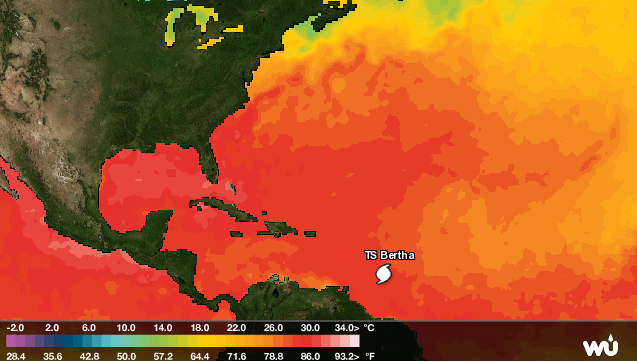
As I said two days ago. If and when Invest 93L hits the warmer water she will have her time to shine and so she has...


What I posted the other day....
...it is exactly what I said...she made it past the cooler water
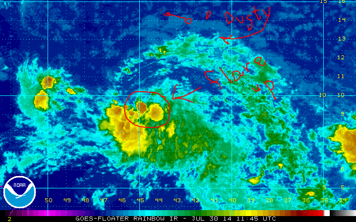
and the warmer water will help..she also moves further away from the dust.

See image below from the other day....


In order for a tropical system to get going it needs fuel... the fuel is the warmer water. That is on the most basic level. Trying to keep this simple. Turn the hot water on and the storm flares up. We'll see how she is tomorrow.

Watches and warnings are up and as follows.

THE METEOROLOGICAL SERVICE OF BARBADOS HAS ISSUED A TROPICAL STORM
WARNING FOR BARBADOS AND DOMINICA.

THE GOVERNMENT OF ST. LUCIA HAS ISSUED A TROPICAL STORM WARNING FOR
ST. LUCIA.

A TROPICAL STORM WATCH HAS BEEN ISSUED FOR PUERTO RICO...VIEQUES...
CULEBRA...AND THE U.S. VIRGIN ISLANDS.

THE METEOROLOGICAL SERVICE OF BARBADOS HAS ISSUED A TROPICAL STORM
WATCH FOR ST. VINCENT AND THE GRENADINES.

A TROPICAL STORM WARNING COULD BE REQUIRED FOR MARTINIQUE FRIDAY
MORNING.

SUMMARY OF WATCHES AND WARNINGS IN EFFECT...

A TROPICAL STORM WARNING IS IN EFFECT FOR...
* BARBADOS
* ST. LUCIA
* DOMINICA

A TROPICAL STORM WATCH IS IN EFFECT FOR...
* PUERTO RICO
* VIEQUES
* CULEBRA
* U.S. VIRGIN ISLANDS
* ST. VINCENT AND THE GRENADINES

Remember this is not a hurricane, it is barely a Tropical Storm but appropriate precautions need to be taken....and mostly that means keep checking back to make sure it is still just a minimal tropical storm. To people who ask me  (like someone I know...) "I'm leaving for San Juan tomorrow should I be worried?" My answer is no.... go... stay abreast of the news. This is not much more than some wind and rain. Stay inside and hunker down and all should be good after the storm. IF things change ... there will be adequate warnings. And... always take pictures.....

Besos Bobbi

Note at 11 PM the NHC keeps Bertha as a minimal Tropical Storm. They are often better on track than intensify forecasting, but this is the forecast.

FORECAST POSITIONS AND MAX WINDS

INIT  01/0300Z 12.3N  55.5W   40 KT  45 MPH
 12H  01/1200Z 13.2N  58.0W   40 KT  45 MPH
 24H  02/0000Z 14.5N  61.4W   40 KT  45 MPH
 36H  02/1200Z 16.1N  64.7W   45 KT  50 MPH
 48H  03/0000Z 17.9N  67.9W   45 KT  50 MPH
 72H  04/0000Z 22.0N  73.0W   35 KT  40 MPH
 96H  05/0000Z 26.8N  75.2W   40 KT  45 MPH
120H  06/0000Z 32.0N  74.7W   45 KT  50 MPH

Oh and Miami though not in the cone has a 34% chance of feeling something from the storm. We will discuss this much later ... trust me.

W PALM BEACH   34  X   X( X)   X( X)   X( X)   X( X)   2( 2)   2( 4)

MIAMI FL       34  X   X( X)   X( X)   X( X)   X( X)   2( 2)   1( 3)

GRAND BAHAMA   34  X   X( X)   X( X)   X( X)   X( X)   5( 5)   3( 8)

https://www.youtube.com/watch?v=hHVBzLGAIbU


Invest 93L Has a Well Defined Center... but can it keep it's convection? The Recon Planes go in...


The beauty of a naked circulation is that you can see the circulation. You can see all the way down into the "A well-defined low pressure system" 

The only real important update from the NHC this morning is that they are calling it like they see it. It is a very well-defined low pressure system.

Official NHC discussion:

"TROPICAL WEATHER OUTLOOK
NWS NATIONAL HURRICANE CENTER MIAMI FL
800 AM EDT THU JUL 31 2014

For the North Atlantic...Caribbean Sea and the Gulf of Mexico:

1. A well-defined low pressure system located about 650 miles east of
the southern Windward Islands has been producing organized shower
and thunderstorm activity during the past several hours.  If this
activity persists, tropical depression or tropical storm advisories
will be initiated later this morning.   Interests in the Lesser
Antilles should monitor the progress of this disturbance as it moves
west-northwestward at 15 to 20 mph, and watches or warnings may be
required for some of these islands later today.  A Hurricane
Hunter aircraft is scheduled to investigate the system this
afternoon.
* Formation chance through 48 hours...high...70 percent.
* Formation chance through 5 days...high...70 percent.

Forecaster Pasch"

The other important piece of information is that the planes are taking off...


"NOAA’s G-IV jet is scheduled to fly around the tropical disturbance that is located in the mid-Atlantic (AL93). The jet will collect data in he environment northwest and around AL93. The flight will take off at 1:30 PM Eastern. Below is the flight track."


Look at this close up. Hidden in the "center" is the word "Hi!" that rhymes by the way with EYE.

If and when TD3 gets a name and becomes Bertha that area would become the eye of a hurricane or the CDO of a strong Tropical Storm. Because it's late summer... hot and dry from Saharan Dust Invest 93L has peeled off her white clothing and gotten down to the basics. And, because she is "naked" as we like to say we can see where her center is very clearly.

Let me make this clear. For years we would call tropical waves under investigation an "INVEST" and now the term has gone public and is being used by the media. An INVEST is a TROPICAL WAVE that is being investigated by the powers that be who are running models on it for forecast purposes.

Once a closed circulation develops around a well-defined low pressure system (tropical wave) it becomes a Tropical Depression and advisories and sometimes watches & warnings begin. When that Tropical Depression attains the wind speed of 39 mph it becomes a Tropical Storm. They only give wind speeds in increments of 5 so most people think it starts at 40mph. Now you know how the system works.


Now let's talk about what is going and what is steering our future TD3 or Bertha.

Loop the link below...
http://www.ssd.noaa.gov/goes/east/tatl/wv-animated.gif


As I mentioned the other day IF a small ULL would form to the immediate NW of the Invest it would stoke the fires of the "well defined center" of the tropical wave and the wave would FLARE up like someone fanning a small fire. And, that is what is happening. That is why Invest 93L is alive and kicking this morning.  Yes it has dry air and it has to battle with shear down the road but if you are on the right side of an ULL it can ventilate a wave and ratched it up a notch to a Tropical Depression and possibly a named storm.

That is why the planes are going in and that is why the models woke up this morning and latched onto INVEST 93L as an entity that may need to be reckoned with down the road...

Note the ULL is hard to see but it doesn't exist and it's not a strong one. If it was stronger it would kill it. Because they are both weak... it's doing it's thing and helping Invest 93L along.

What do the models show? Where does it go?


I will update this later today with more track information as after the planes get there we will have better data for the next run of the models. Garbage in ...garbage out is the old saying. Better data in...more reliable tracks out.

http://www.ssd.noaa.gov/PS/TROP/floaters/93L/imagery/ft_lalo-animated.gif


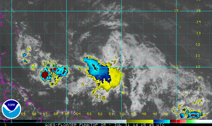
The biggest problem Invest 93L has at the moment is it's inability to maintain convection around it's naked center. It flares up..turns bright red on funktop and then the red dissipates again.

Another possible problem it has is that new convection far to the LEFT (WEST) of the naked center persists in blowing up and weak systems often attain multiple centers. IF at any time the NHC has to "reposition" the center to the West than it will be on top of the islands and the track will most likely be more to the south of the current track into the islands and more to the left (west) of the track later in the forecast period as it approaches Florida. That is a real IF but something to know can happen.

Stay tuned to see if Invest 93L becomes viable and attains a real designation as a TD or TS.

Besos Bobbi

Ps.. I do have a song but it's not for now it's for after it deserves a song.  It's got a way to go and it's not very consistent. The NHC likes consistency before it upgrades a storm. They also like hard data and the recon will get them that...

Wednesday, July 30, 2014

If Only Invest 93L Looked as Good as the Cold Front...... The Tropical Drama of the Search for Tropical Storm Bertha


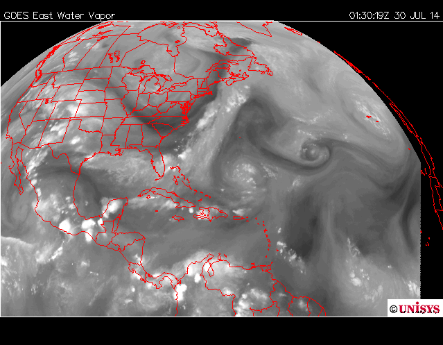
The first good morning visible shows us the circulation of Invest 93L is intact and spinning. There is a lack of convection although there has been a burst of convection at it's center which is a good sign that it's hanging in and fighting. Of course, if you have a vacation coming up in the Virgin Islands that may not be a good sign. The rudimentary signs of circulation are still visible and an "elephant trunk" like feature is there on the NW side that is typical of developing waves. Of course the dry air and Saharan Dust is also visible . . .

Note if you loop this loop you will see the dust is going WEST separate from the Invest.
http://www.ssd.noaa.gov/PS/TROP/floaters/93L/imagery/vis_lalo-animated.gif

A good satellite image to show this has been enhanced by my artsy explanation.
(for the viewers who do not like long reads ;) winking at you know who)


For long read people it's like this:
This little invest with a great shape but lacking something upstairs cannot shake a guy named Dusty SAL who hovers around stalking her as she tries to make it across the Atlantic and win the name Bertha. Other gorgeous waves have tried to attain that name before yet alas the very handsome SAL with the big bad edge will not let them breathe. SAL follows her where ever she goes taking pictures and posting them on his facebook page. Sal just figures if he doesn't let go she will eventually succumb to his dusty charm. Either way upper level winds are going to huff and puff and blow both SAL and our Bertha wannabee away. Stay tuned to see how this tropical romance works out . . .

The trailer for this movie to be released in a week or so is below: 
http://tropic.ssec.wisc.edu/real-time/sal/splitE/movies/splitE5.html

sat_wv_east_loop-12.gif (640×512)

Actually the two Upper Level Lows are creating a lot of problems for both SAL and our Invest. There is a hand off of energy from the lead ULL to the one further East. If this was a football game we could say they have a great defense and we are lacking a good offensive line. Oh.. sort of like the Miami Dolphins, but I digress... If another ULL forms to it's immediate NW such a set up could enhance convection and give it the spark it needs to keep going the distance. 


The NHC gives it a 70% chance at 8 AM of forming eventually......that's more than I would give it. Rule of thumb.. if it doesn't form before the Eastern Caribbean it's not going to form. Exceptions exist like Camille that refired up near Jamaica when it hit a sweet spot and headed for the Gulf of Mexico. Did I mention that was an exception to the rule.

So it will hit strong upper level winds closer to the Caribbean. It has a spot it could develop but it has to get there. There is a strong drought going on in the Antilles and they could use a drought buster enough to hope for a mild tropical storm. Invest 92L blew through with wind, rain and Invest 93L is bigger and could provide more rain. The larger envelope of moisture will help erode the dry air some and as we often say in wxr slang "juice up the atmosphere for the next wave" meaning that each Invest makes it easier for the next to form.......

At the moment the "juice loop" shows our hapless Invest being almost completely cut off from her moisture feed and about to succumb to Dusty Sal.

http://tropic.ssec.wisc.edu/real-time/mimic-tpw/natl/anim/latest72hrs.gif


Green showing up to the SE and East of her is not good. 
She may end up like Gatsby dead at the bottom of the pool...


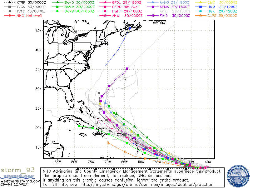
Models still clustered around a turn to the NW . . .
Hard for me to see unless our Invest becomes Bertha.
If not it will track further to the west (left) as a weak TD or Tropical Wave.


According to these models Puerto Rico is probably on the safe side but the Virgin Islands are still too close to call..... if.......Tropical Storm Bertha forms. Note the BAMD isn't buying it and sees the high building back in and pushing Bertha down... WSW. 

It does worry me a bit that the elusive Tropical Storm Bertha could sneak in under the radar and form closer in... in da Bahamas...   That would be within the logic for this season having hurricanes forming close in when they get past the unfavorable environment further out in the Atlantic. The models show the questions that only Invest 93L can answer..

The 7th day of the 7 Day forecast shows two possible scenarios. One it goes west into the Carib and then NW around the high. Or it gets into an area where the previous front bombed out (the one that is currently zooming thru Mississippi, Alabama & Florida) and goes stationary in a day or two from now and that would leave a question mark for where the remnants of this wave might end up. 


Sunrise over Key West this morning as the nearness of that front is stirring up the atmosphere...
hidden in the darkness is Louie's Backyard...


If only Invest 93L looked as good as the cold front...


If only the once & future Bertha looked as good as Hilary Duff...

https://www.youtube.com/watch?v=rmsx3Dvehy0


I can so relate...how I've been all week....
https://www.youtube.com/watch?v=Org0Z83lTlE


https://www.youtube.com/watch?v=z4znyqGIWH8

I'll be back later if there is something to say to update y'all on the situation in the tropics regarding Invest 93L. I'm not expecting a lot... but you never know. 

Only time will tell.

Besos Bobbi Storm

Ps. A bit annoyed with TWC this morning. They are trying to help us understand how lightning storms work and how we should react should we start to leave the house and we hear a massive clap of thunder. Unfortunately life doesn't work that way for parts of the world. IF you are in LA walking along Venice Beach and you hear thunder do exactly what they say on TWC and seek cover inside a building (not a tree) and wait 30 minutes.  But seriously if you live in Miami  "Stay inside for 30 minutes after you hear the first clap of thunder??????????" Miami and Tampa would cease to exist as busy urban cities where it rains and pours every afternoon and lightning is as normal as.................well they call the Ice Hockey team "Lightning" for a reason...

http://lightning.nhl.com/


Bonus song for reading this all the way down to the bottom ;)

https://www.youtube.com/watch?v=7nqH4-amR88

Tuesday, July 29, 2014

Invest 93L in a Dry Environment. Struggling to Stay Afloat.


To be honest Invest 93L is not looking very good Tuesday evening. That is not to say it cannot come back, but it is having a problem with the dust I mentioned earlier. I'm a little confused why the NHC didn't mention the dust as it's obviously still a problem.

That little green dot to the far right of the image above is Invest 93L. This site is infamous for making a bad storm look good.  This is as good as I could get it . . .


A close up look shows a small ball of convection that may be moving faster than the rest of the wave. Sometimes a center out runs it's convection. I am not saying that is what is happening, I'm saying it's a possibility. Also, dry air has entered the system and it can't seem to get up..

I'm going to post an image I posted earlier. Shows the dry air and my question mark is why...how this system gets to where the models say it is going to get with so much going against it. 


Worried on why the models are not handling this system well. The models did not see Invest 92L coming and that was blamed on the small size of the last invest. This invest is big... huge..and the models still are not handling it well.

Look at the system 12 hours ago. See the Invest in the bottom right of the image ..


Now look at the system 12 hours later... an image from 11PM. Hard to even find it...


The models began to bother me when I saw several of them show Invest 93L as a Tropical Storm barrel through a strong high. Made no sense. I could see that happening if it was a hurricane. Easy to believe the model sees things I do not, that is the purpose of the models to see into the future and see things we might not see. In this case.......not sure what the models were thinking.

Note had the Invest 93L intensified rapidly this track might be plausible. But, as a weak wave it is going to keep going west or be blown apart by shear from the ULL to the NE of PR.

The ULL to the North and NW are sucking the moisture up out of the not so developing storm.


Lastly note that yesterday there was a lot of moisture out in front of the Invest.See the bright orange yellow area between 50W and 40W.


Current "juice loop" shows a lack of "juice" . . .
Understand that tropical systems need warm moist air about as much we need water when we are out walking around in 90 degrees in the hot tropical sun in Key West in almost August. (It's 87 degrees here in Key West at 11 PM at night..........think on it)


A break in the moisture......not good for Invest 93L.
It's like someone suddenly turned the stove off and the chicken ain't cookin...

We'll see tomorrow what happens. But, I wouldn't be surprised if the NHC lowers the % down a bit on Invest 93L. 

As for track discussion it's silly until we have a well defined system that the models can track. 

IF it stays weak it will go further west or fall apart all together as Invest 92L did and the search goes on for the B storm.. Bertha.........

If it revives a bit over night and has delayed development it will probably miss the islands and pull north towards a weakness in the ridge. The High is forecast to pull back to the East a bit and that leaves the door way to curving out to sea near the Bahamas and hopefully missing the islands.

Right now Invest 93L seems to have missed the boat.

As always the tropics work in real time so let's see what happens Wednesday... 

I'll update with information as the situation warrants.

Besos Bobbi

PS.. Worth noting that shear is expected to weaken tomorrow and it will get into warmer water so that should give it the mojo it needs to get itself going again.

And.. remember to purchase a shirt and the proceeds are donated to a fund to help Stormchaser Jim Leonard "Cyclone Jim" who is battling terminal cancer. Scroll down to the information on the shirt. Thanks.
http://www.skiesovertheplains.com/

Not So Fast Bertha... Invest 93L Taking Her Time. Why that isn't necessarily good...


This morning's funktop satellite image shows the problem.
1. It lacks deep convection. Gone are the reds of last night & definitely no green there anywhere.
2. Look to the north and those dotted white clouds are loaded with Saharan Dust.


Let's take a look at a before and after picture of Invest 93L. 
The image on the left is last night & the image on the right is this morning.
Notice it's circulation looked better & it ingested that line of SAL to it's NW & then... whoosh went the good looks and it looked like it partied to hard in the middle of the night. Less of a stellar appearance and more exhausted, ragged & lacking convection.

Again image on the left looks like an eye was about to pop out ... 
The image on the right is after it coughed up too much SAL.. think pollen in the Spring in Georgia.

On the plus side it has style, rudimentary banding and a sense of a center. It has a weak low pressure center attached. It is moving slowly towards warmer water and less SAL.


I outlined the edges of the cooler water with a blue line... 
Invest 93L has to get past there... compare that with the image above of SAL
So the end game here is "she" forms further West 
and....
that will drag the models & the cone further west
and....
takes it for now through the Hebert Box that often spells trouble for South Florida


(that's HEBERT not HERBERT... never to be confused)


Many may think the fact that she is not Bertha today is good. It is good to say we have no hurricane today.  But, as I pointed out above the problem is that IF we had a tropical storm today and a Hurricane Bertha tomorrow it would be a lock on the Fish storm scenario and it would recurve up and out to sea... as we say a Fish Storm and I don't mean a Fish Burger but pescado frito. 

A system that goes slower, takes it's time until it reaches warmer water that has less Saharan Dust gets further west & when it makes that turn the chance of a landfall is more in play. That landfall would most likely be in the Virgin Islands near PR or the Lesser Antilles. A hurricane that makes that turn there usually does huge damage both in the islands and down the line with a second landfall. Not always .... many curve out to sea or die a slow death over Hispaniola. But, the ones that do are memorable.


Cleo made the history books. 
Islands, Haiti, Cuba, Miami... East Coast


Hugo (not to scare you but just an example)


Sometimes they don't recurve like George in 1998


And sometimes they curve out to sea early... 
....because they get strong early...


Sooooo.... a slower storm gets further West.
Remember that.
A stronger storm makes a turn faster.
Usually... but not always... but more often than not.

I think the NHC is doing a great job with this system. There is NO reason to rush to give it designation. Wait for it to get closer to land and/or develop a strong center with stronger convection pops out on satellite imagery. Taking their time to analyze the storm, the environment and the models is the way to go with a long tracking storm. What does confuse me is that they don't mention the SAL in their discussion of this Invest as it's apparent that it is literally taking a bite out of her... 

Note they do mention SAL with regard to other systems ... 
8AM Tuesday Morning


BobbiStorm's Bottom Line is shown below. 
Red line is newest models, white older ones.
Slower it takes to develop the further West it goes...


Track down the distant road depends on IF there is a cold front to pick it up and blow it away. It could still make the turn but some part of the East Coast could be in the way...down the road. Just something to think on while getting rid of that "El Nino is coming" song that was previously playing in your head. 

Again...........do not pay much attention to every model that may imply a hit on PR or Miami or Carolina or NY or Cape Cod though I do think unless it goes into the Caribbean (a possibility) the Bahamas are the cross hairs. Nothing set in stone. Just keep watching and have a great day!

Besos Bobbi
@Bobbistorm

Ps... I know love watching the tropics from Key West. Sunrise, cafecito & fast speed Internet... what a way to start the morning :) As for TD3 or Bertha it could be named at any time... when the NHC decides to however the track map being up on the Navy site is usually a good sign it's close to being designated and advisories are about to start soon.


Monday, July 28, 2014

Invest 93L Consolidating... TD3 or Tropical Storm Bertha Due Soon. East Coast/Carib Needs to Pay Attention.


Close up view of Invest 93L soon to be Tropical Storm Bertha.
The arrows or barbs... show the wind direction and yes this how we do it...
when they are far out beyond the realm of recon.

We also use a Dvorak rating. You'll see it mentioned below as 1.0


Notice the white dot in the middle of the darker dot... 
...her center is beginning to show up on satellite imagery.


Another view of Invest 93L tonight that shows the banding beginning to form within the storm.


I've highlighted the banding features in yellow.. 


She is a big girl gotta tell you that. 
If a storm could get an award for being 180 degrees different from the last...
she would win the award... 

And, she is beginning to come together fast this evening.

Where would she be going down the road. Um.... 
a) Towards the islands.
b) Towards South Florida
c) Towards the Carolinas
d) Going to catch a cold front & swim out to sea like a good Fish Storm
e) ALL OF THE ABOVE ARE POSSIBLE

And that is why we obsess on Cape Verde Storms. They have a long way to go before all is said and done and their track can be iffy especially this time of year. 


Note models can and do change constantly in real time.

And more important that models on 93L is that there is a wave behind her...


A bit of a warning here tonight. IF Invest 93L becomes Bertha as the models predict she will catch every one's attention as she will be a large hurricane unable to ignore across a large swath of the East Coast and the Caribbean. If she got into the Gulf and NO MODEL SHOWS THAT NOW... add in that real estate there.

When there is a HUGE Hurricane on the map everyone gets nervous much the way that when the lotto goes really large everyone buys more tickets.

It's too soon to tell.

It is not too soon to realize that the early predictions for a quiet season with a strong El Nino can be tossed in the shredder or the nutribullet and we need to start over all over again with what we think the 2014 Atlantic Hurricane Season will bring... 

And, I'm not really happy that all the long range models were wrong. We need to rely on those models.

Stay tuned. We're in for a bumpy ride.

Sweet Tropical Dreams from Key West

BobbiStorm

Ps...C name is Cristobal