If Only Invest 93L Looked as Good as the Cold Front...... The Tropical Drama of the Search for Tropical Storm Bertha

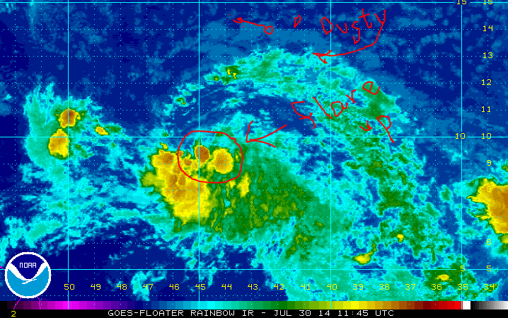
The first good morning visible shows us the circulation of Invest 93L is intact and spinning. There is a lack of convection although there has been a burst of convection at it's center which is a good sign that it's hanging in and fighting. Of course, if you have a vacation coming up in the Virgin Islands that may not be a good sign. The rudimentary signs of circulation are still visible and an "elephant trunk" like feature is there on the NW side that is typical of developing waves. Of course the dry air and Saharan Dust is also visible . . .
Note if you loop this loop you will see the dust is going WEST separate from the Invest.
http://www.ssd.noaa.gov/PS/TROP/floaters/93L/imagery/vis_lalo-animated.gif
A good satellite image to show this has been enhanced by my artsy explanation.
(for the viewers who do not like long reads ;) winking at you know who)
For long read people it's like this:
This little invest with a great shape but lacking something upstairs cannot shake a guy named Dusty SAL who hovers around stalking her as she tries to make it across the Atlantic and win the name Bertha. Other gorgeous waves have tried to attain that name before yet alas the very handsome SAL with the big bad edge will not let them breathe. SAL follows her where ever she goes taking pictures and posting them on his facebook page. Sal just figures if he doesn't let go she will eventually succumb to his dusty charm. Either way upper level winds are going to huff and puff and blow both SAL and our Bertha wannabee away. Stay tuned to see how this tropical romance works out . . .
The trailer for this movie to be released in a week or so is below:
http://tropic.ssec.wisc.edu/real-time/sal/splitE/movies/splitE5.html

Actually the two Upper Level Lows are creating a lot of problems for both SAL and our Invest. There is a hand off of energy from the lead ULL to the one further East. If this was a football game we could say they have a great defense and we are lacking a good offensive line. Oh.. sort of like the Miami Dolphins, but I digress... If another ULL forms to it's immediate NW such a set up could enhance convection and give it the spark it needs to keep going the distance.

The NHC gives it a 70% chance at 8 AM of forming eventually......that's more than I would give it. Rule of thumb.. if it doesn't form before the Eastern Caribbean it's not going to form. Exceptions exist like Camille that refired up near Jamaica when it hit a sweet spot and headed for the Gulf of Mexico. Did I mention that was an exception to the rule.
So it will hit strong upper level winds closer to the Caribbean. It has a spot it could develop but it has to get there. There is a strong drought going on in the Antilles and they could use a drought buster enough to hope for a mild tropical storm. Invest 92L blew through with wind, rain and Invest 93L is bigger and could provide more rain. The larger envelope of moisture will help erode the dry air some and as we often say in wxr slang "juice up the atmosphere for the next wave" meaning that each Invest makes it easier for the next to form.......
At the moment the "juice loop" shows our hapless Invest being almost completely cut off from her moisture feed and about to succumb to Dusty Sal.
http://tropic.ssec.wisc.edu/real-time/mimic-tpw/natl/anim/latest72hrs.gif

Green showing up to the SE and East of her is not good.
She may end up like Gatsby dead at the bottom of the pool...

Models still clustered around a turn to the NW . . .
Hard for me to see unless our Invest becomes Bertha.
If not it will track further to the west (left) as a weak TD or Tropical Wave.

According to these models Puerto Rico is probably on the safe side but the Virgin Islands are still too close to call..... if.......Tropical Storm Bertha forms. Note the BAMD isn't buying it and sees the high building back in and pushing Bertha down... WSW.
It does worry me a bit that the elusive Tropical Storm Bertha could sneak in under the radar and form closer in... in da Bahamas... That would be within the logic for this season having hurricanes forming close in when they get past the unfavorable environment further out in the Atlantic. The models show the questions that only Invest 93L can answer..
The 7th day of the 7 Day forecast shows two possible scenarios. One it goes west into the Carib and then NW around the high. Or it gets into an area where the previous front bombed out (the one that is currently zooming thru Mississippi, Alabama & Florida) and goes stationary in a day or two from now and that would leave a question mark for where the remnants of this wave might end up.

Sunrise over Key West this morning as the nearness of that front is stirring up the atmosphere...
hidden in the darkness is Louie's Backyard...

If only Invest 93L looked as good as the cold front...

If only the once & future Bertha looked as good as Hilary Duff...
https://www.youtube.com/watch?v=rmsx3Dvehy0

I can so relate...how I've been all week....
https://www.youtube.com/watch?v=Org0Z83lTlE
https://www.youtube.com/watch?v=z4znyqGIWH8
I'll be back later if there is something to say to update y'all on the situation in the tropics regarding Invest 93L. I'm not expecting a lot... but you never know.
Only time will tell.
Besos Bobbi Storm
Ps. A bit annoyed with TWC this morning. They are trying to help us understand how lightning storms work and how we should react should we start to leave the house and we hear a massive clap of thunder. Unfortunately life doesn't work that way for parts of the world. IF you are in LA walking along Venice Beach and you hear thunder do exactly what they say on TWC and seek cover inside a building (not a tree) and wait 30 minutes. But seriously if you live in Miami "Stay inside for 30 minutes after you hear the first clap of thunder??????????" Miami and Tampa would cease to exist as busy urban cities where it rains and pours every afternoon and lightning is as normal as.................well they call the Ice Hockey team "Lightning" for a reason...
http://lightning.nhl.com/

Bonus song for reading this all the way down to the bottom ;)
https://www.youtube.com/watch?v=7nqH4-amR88
posted by BobbiStorm @ 6:32 AM
![]()


0 Comments:
Post a Comment
<< Home