Tropical Storm Bertha. Really. Burst of energy pushes her over the top...

May not look like much but tonight she is officially Tropical Storm Bertha. And so she should be. There is no law written that a Tropical Storm has to look beautiful and perfect. It is the first real step in becoming a Hurricane...and many don't attain that status. For now she's got a name. Bonus song at the bottom of this post ;)
Think of it like this:
Tropical Wave = Pre-School
Invest = Elementary
TD = Middle School
TS = High School
Hurricane = College
Major Cat 3 and above = Masters Degree, Doctorate, Lawyer, Indian Chief
I was annoyed earlier in the evening that it had not been upgraded. The parameters had been met. Closed circulation, strong winds and low pressure were all there. It's nice to have a lot of convection but this is a system that is already approaching the islands and watches need to be posted. It also has a history of quickly flaring up before dying down and if it flares up just before hitting land it could cause problems.
After the 5 pm I posted may thoughts on Twitter. Between 5 and 11 there was a sudden burst of intensification and the NHC (based on data from recon) upgraded it to Tropical Storm Bertha as the wind speed was there...

Official line from discussion at 11 PM.
"Reports from an Air Force Reserve reconnaissance aircraft earlier
this afternoon and evening indicated that the well-defined low
pressure system located about 250 nmi east-southeast of Barbados had
surface winds of about 40 kt north and northeast of the center.
Since the departure of the aircraft, a band of deep convection has
developed near and to the north and east of the low-level center,
and now has enough organization to consider this system a tropical
cyclone."
The loop below is time sensitive so only Bertha knows what it will look like in the morning when you may be reading this....

Track:

Note Bertha already forecast to cross the Lesser Antilles..
... Getting closer to Hispaniola in play...
Turns before hitting Florida hooks off the Outer Banks
About as typical as it gets.
So far.
Stay tuned.
For now Bertha comes in as a late July storm a day short of August. Pretty busy season for a year where El Nino was supposed to rule and Cousin Sal would shut down the Atlantic.
As I said two days ago. If and when Invest 93L hits the warmer water she will have her time to shine and so she has...
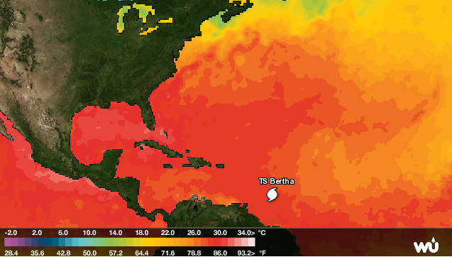
What I posted the other day....
...it is exactly what I said...she made it past the cooler water
and the warmer water will help..she also moves further away from the dust.
See image below from the other day....

Watches and warnings are up and as follows.
THE METEOROLOGICAL SERVICE OF BARBADOS HAS ISSUED A TROPICAL STORM
WARNING FOR BARBADOS AND DOMINICA.

THE GOVERNMENT OF ST. LUCIA HAS ISSUED A TROPICAL STORM WARNING FOR
ST. LUCIA.

A TROPICAL STORM WATCH HAS BEEN ISSUED FOR PUERTO RICO...VIEQUES...
CULEBRA...AND THE U.S. VIRGIN ISLANDS.

THE METEOROLOGICAL SERVICE OF BARBADOS HAS ISSUED A TROPICAL STORM
WATCH FOR ST. VINCENT AND THE GRENADINES.

A TROPICAL STORM WARNING COULD BE REQUIRED FOR MARTINIQUE FRIDAY
MORNING.

SUMMARY OF WATCHES AND WARNINGS IN EFFECT...

A TROPICAL STORM WARNING IS IN EFFECT FOR...
* BARBADOS
* ST. LUCIA
* DOMINICA

A TROPICAL STORM WATCH IS IN EFFECT FOR...
* PUERTO RICO
* VIEQUES
* CULEBRA
* U.S. VIRGIN ISLANDS
* ST. VINCENT AND THE GRENADINES
Remember this is not a hurricane, it is barely a Tropical Storm but appropriate precautions need to be taken....and mostly that means keep checking back to make sure it is still just a minimal tropical storm. To people who ask me (like someone I know...) "I'm leaving for San Juan tomorrow should I be worried?" My answer is no.... go... stay abreast of the news. This is not much more than some wind and rain. Stay inside and hunker down and all should be good after the storm. IF things change ... there will be adequate warnings. And... always take pictures.....
Besos Bobbi
Note at 11 PM the NHC keeps Bertha as a minimal Tropical Storm. They are often better on track than intensify forecasting, but this is the forecast.
FORECAST POSITIONS AND MAX WINDS

INIT  01/0300Z 12.3N  55.5W   40 KT  45 MPH
 12H  01/1200Z 13.2N  58.0W   40 KT  45 MPH
 24H  02/0000Z 14.5N  61.4W   40 KT  45 MPH
 36H  02/1200Z 16.1N  64.7W   45 KT  50 MPH
 48H  03/0000Z 17.9N  67.9W   45 KT  50 MPH
 72H  04/0000Z 22.0N  73.0W   35 KT  40 MPH
 96H  05/0000Z 26.8N  75.2W   40 KT  45 MPH
120H  06/0000Z 32.0N  74.7W   45 KT  50 MPH
Oh and Miami though not in the cone has a 34% chance of feeling something from the storm. We will discuss this much later ... trust me.
W PALM BEACH 34 X X( X) X( X) X( X) X( X) 2( 2) 2( 4)
MIAMI FL 34 X X( X) X( X) X( X) X( X) 2( 2) 1( 3)
GRAND BAHAMA 34 X X( X) X( X) X( X) X( X) 5( 5) 3( 8)
https://www.youtube.com/watch?v=hHVBzLGAIbU
posted by BobbiStorm @ 9:37 PM
![]()


0 Comments:
Post a Comment
<< Home