UPDATED TD 3 in BOC Possibly TC Chris By Landfall- Major Hurricane Beryl 130 MPH Forecast to be Cat 4 at Landfall by NHC. Beryl Chose a Bad Time to Do Rapid Intensification While Moving W at 21 MPH Windward Islands in Direct Path of a Destructive Dangerous Cat 4 Cane!

Last day of June.
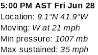
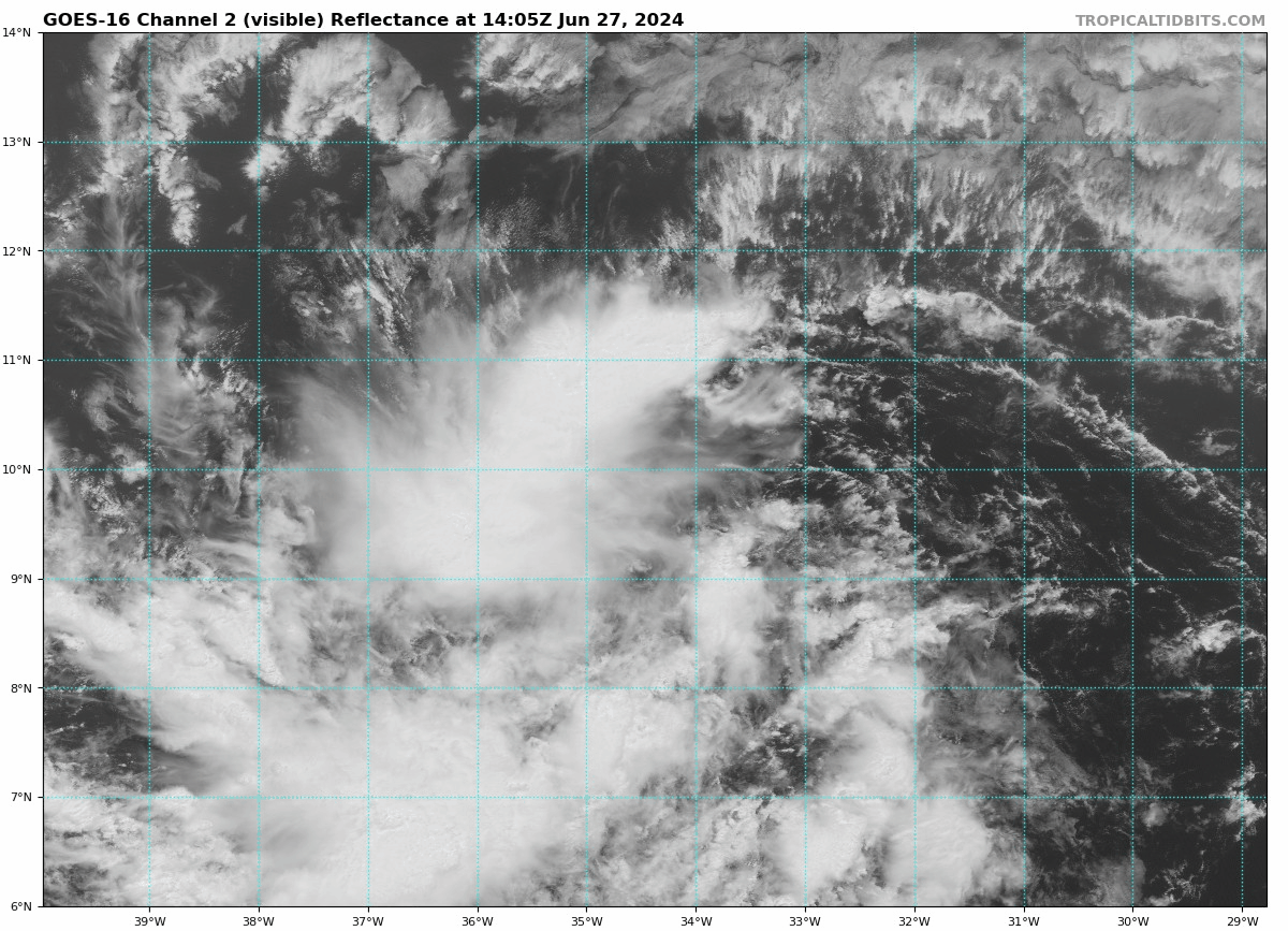
TD 3 in BOC
130 MPH Beryl forecast to be 145 MPH
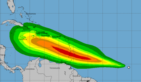
Invest 96L 70% Red
Are we busy enough yet?
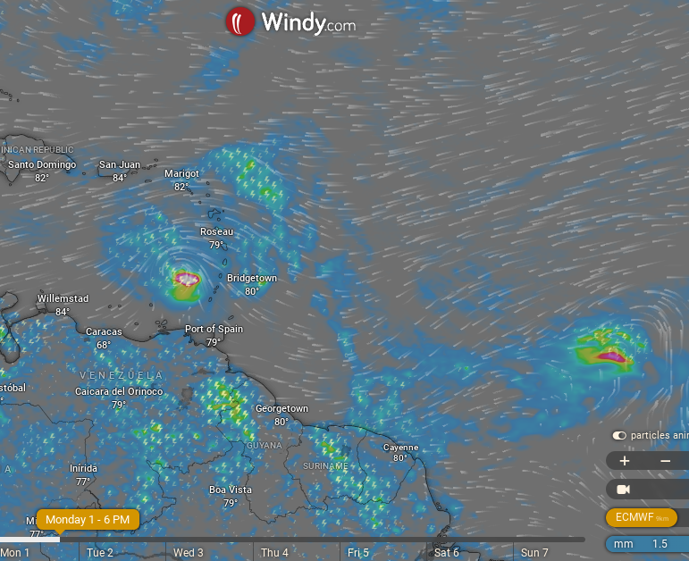
St.Vincent, the Grenadines and Grenada are currently seen to be the places to get the most direct impact from the eye of Hurricane Beryl. I'm talking the most severe winds and pounding storms in the eyewall and hopefully it continues it's fast forward speed, at least sparing these Islands a long, drawn out ordeal. Either way those are strong winds and it'll be the first time since 2004 when Ivan directly impacted them in this particular way. My heart goes out to people there and many people vacationing who traveled there believing that nothing horrible, tropically happens in June or July. In truth, if and when conditions are right... we can always have something develop, but it's definitely extremely rare to worry on tropical weather in June. Ivan was a September hurricane, Islands always expect hurricanes in September but not June and July. The financial hit for their economies and toll of cleaning up and rebuilding will be high.
July is tomorrow and tomorrow Major Hurricane Beryl will barrel through the Islands and then we will look down the road for what is next. For now... Jamaica is in the track, unless the track pulls more to the North and there is some indication it might in the discussion from the NHC at 5 PM. In theory it pulls a li'l bit N of West then curves back and continues it's current track. But, in my mind all bets are off until we see what Beryl does and it's good to be aware and prepared when you see a Hurricane to your South or you see it's cone go directly over your beautiful Island.


TD 3 in BOC aka 94L


Homes will be destroyed, businesses and storm surge will rearrange the beaches and it'll take a Cat 5 Miracle for no one to die and most likely the name Beryl will be retired.


Ignorance is bliss, yet as people wake up this morning in the Islands (locals, travelers, tourists) they are finding out there is a Cat 3 Hurricane coming. Many most likely can't believe what they are seeing but know warnings have been hoisted and Major Hurricane Beryl is on the way...soon as in tonight & in the early hours of July 1st. Many may not be able to get out in time... no one expected this in June. Especially people who are not here online obsessing and trading thoughts on every model that showed this could happen. People book cruises, trips feeling this neck of the tropics is safe in June & early July. Old timers always know it could happen, but a lot of people who have not seen a Major Hurricane hit relatively early in the season won't wrap their head around it until it's already there. Much like everyone tells me... "Miami never gets hit, they always turn away" because they do not remember the years when hurricanes did not turn away. Well ...something changed. And, we had a heads up all May when early tropical waves began rolling off of Africa, granted they were very low but they were rolling & looked healthy. Then later in June the wave train began and became real, and yet we were talking waves ending up by the Yucatan ... weak, trying to form into a storm. And, we had Alberto... Then came Invest 95L & there's no going back to the bliss of denial and ignorance. The Wave train is healthy, alive and Invest 96L is already at 70% red directly behind Major Hurricane Beryl. Hopefully there will be some variation in track as usually there is ...because the last thing we need is for Trinidad, Grenada, Barbados, St. Lucia to have a back to back hit. This could be brutal, really brutal and talking during & after during rescue & recovery. Beryl has a small core, it's not a huge hurricane but the more it strengthens the wider the area of influence it has and the further out the winds will go. And, while those winds may not blow as much as the islands in the direct path of Cat 3 or Cat 4 Beryl. This is happening. Take heed and prepare in Houston, in Mobile Alabama, in Destin, in Tampa, in Miami, in Bimini and up the whole Eastern Seaboard as Fish may not be a popular dish that Mother Nature is serving this hurricane season. From Key West to Maine, including New England, pay attention and prepare for hurricane season ...this year! Don't waste money, save it for emergencies. Save it for evacuation and/or hurricane supplies. Buy a generator if you are staying, on Mike's Weather Page there are discounts & I'm sure there's sales on Amazon. Longest post or tweet ...whichever you want to call it ...I've ever written but since I can I am... take the 2024 Hurricane Season forecasts for a busy season seriously. Ignorance may be bliss, but knowledge is power.
So is being Hurricane Ready... if and when you're in the cone of a hurricane down the line this busy hurricane season.
Besos BobbiStorm
Ps Anyone who knows Jim Williams and knows the list he puts out every year of top 20 cities ... know Miami is on that list as several spots in the Cuba and the Bahamas. Recurvature is not a given and in any given year it's just a matter of time. Jim, in fact takes into account years between Landfall and has a whole system of when some city goes on his list as it's time is up... some day, some year soon... so be prepared and take the time now while it's quiet in your part of the world to get a plan, do hurricane prep and figure out what will works best for you and your loved ones...significant others, parents, children, pets...
posted by BobbiStorm @ 8:44 AM
0 comments
![]()