A writer and a tropical muse. A funky Lubavitcher who enjoys watching the weather, hurricanes, listening to music while enjoying life with a sense of humor and trying to make sense of it all!
Thursday, June 27, 2024
Updated 3PM - 80% RED Invest 95L Almost There...Wrapped, Getting Banding & Developing a Center. 94L Still There Close to NHC Possible Formation Zone. 95L Has a Friend Following It.
80% chance of upgrade to TD or TS
Recon goes in tomorrow....
...to the old Yellow Circle to be clear.
Again development could occur in the yellow grid
Not where the X is marked.
Potential development.
30%
Below is a pic that shows both areas.
94L and 95L
Also the SAL to the N of 95L
94L no SAL
95L lots of SAL to it's North.
SAL inhibits development....
..yet everyone once in a while a storm does develop.
This could be that year!
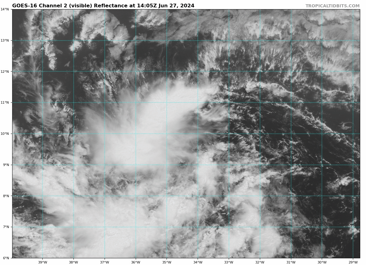
While 95L has a look and a kind of spin, note it lacks the convection that 94L has despite it's lack of substantial center currently. While 95L is in the ocean swimming westbound, the environment is dry and there is less ample moisture for it and that's why it lacks the deep red visible on 94L in a moister environment. Not easy to get a named storm in this region in June, but this year we have two contenders. And, 95L while moving fast is way out there still, with miles to go before we sleep.
Hello Thursday in the Tropics. I had to go out with someone to the doctor's office for routine kind of things, but it was early in the day and barely had time for coffee. Looped with crappy service as that part of Raleigh always has weak signals, but followed along best I could. Home now, madly looping and going over data on Invest 95L as well as 94L close to land, weaker but still there and do not forget about 95L's friend behind it that models pick up on as well. Late June feels a whole lot like late July this year and we will soon find out if the forecasts for a busy season as if on steroids verifies!
On the left we have a big blob of convection that is Invest 94L that wasn't expected to develop until after it passes this area and moves into the BOC as seen by the yellow grid on the image above that is the development zone. Still gotta tell you it's impressive for it to have held together and made it this deep into the Caribbean; if there was no Invest 95L it would be the name of the game today. However, everyone is all a flutter over every variation in new model runs for Invest 95L that has a track in the near future carved in stone yet......intensity m models have it everywhere from a Tropical Storm to even a strong Hurricane. It's important to remember it never was supposed to develop before this area near the Yucatan, so if it's gonna do something we will know soon. NHC has it at 30% development for the next 7 days...10% in the 2 day.
Looks close to TD status.
ASCAT pass showed it almost closed off.
Banding...
Actually fairly beautiful for an Invest.
Short term models are clustered so closely they look like something a child would draw with crayons, tracing over the track of the other over and over. But down the tropical road the model tracks diverge. Some models show it pull ing North towards a break in the ridge towards a frontal boundary dipping down. Other models take it into the Gulf of Mexico. We have all sorts of models. We have short term models, medium range models and Superman using his Xray vision Long Range Models to try and find where landfall might be, scanning around for any port of call with beautiful beach 95L might want to visit. Ensemble models spray out every possible track and show us where there's a concensus while we stare at the one track that takes it to Daytona or Destin or Biloxi Mississippi! Don't get lost in the spray of possible tracks, get lost in the overall pattern of movement.
So much agreement in the beginning.
Then model tracks go off the rails.
This is typical and until a system has formed and Recon has obtained data to put into the models that will be, in theory, better on the next run we look at short term models and we peek at long term models; we all look at the long term models some just refuse to admit it and complain more than 60% of Weather Twitter is posting the doomsday model 385 hours out. As for Intensity you can see how wide apart the models are on 95L's future intensity. Obviously, one model that's fairly good with intensity makes this a hurricane to remember.
In truth.........we will remember this Invest for no other reason than it's actually here, in late June looking as if it's about to get it's own Cone from the NHC still too far East to get Recon into it. But, it's moving steady and fast and it'll be an issue for the Islands and at some point a Cone will show up whether it's a Potential Tropical Cyclone Cone or a real designated TD or TS. Beryl should be the name, unless 94L has some real surprises for us.
Oh and there's a system behind 95L that many models develop as well as named tropical storms suddenly litter the possibilities on the meteorological maps the models toss at as every so many hours.
This coming Monday, July 1st above.
EURO develops 95L (not shown, same place)
GFS tries and develop both.
(no surprise there right?)
Long range.
GFS develops something in EPAC
(there's a surprise ...so far quiet)
Develops 95L
Messy blob like area close in to FL
Just rain but something to think on.
Friday, a week from tomorrow.
That's it for now. Wondering if NHC will update 95L today or wait til tomorrow for first morning visible and for it to totally come together. Models all have it in the Islands as a developed storm on Monday so would think they would want to put up a Cone one way or the other for a heads up as a prelude to putting up\
watches late Friday but every year the NHC is a bit different of late and they have of late done a good job, so they will do what they gotta do.
Stay tuned.
Will update later today if the NHC blinks on a potential cyclone cone though without it being a TD they may wait til tomorrow morning. Time will tell and time is rushing like a river out of control in the Midwest.
Location: Miami, Raleigh, Crown Heights, Florida, United States
Weather Historian. Studied meteorology and geography at FIU. Been quoted in Wall Street Journal, Washington Post & everywhere else... Lecturer, stormchaser, writer, dancer. If it's tropical it's topical ... covering the weather & musing on life. Follow me on Twitter @ https://twitter.com/#!/BobbiStorm


0 Comments:
Post a Comment
<< Home