Harvey in the GOM, FLOODING EVEN WAY IN LAND Likely ... Recon Going In Today. 92L ... New Wave Over Africa. Slow Moving Harvey... Buy Storm Supplies Now... Cantore on the Way... And Where Cantore Goes Storm Chasers Follow
Our systems below

8 AM from the NHC

Let's look at the detail.
The devil is likely in the details.
Actual discussion blown up.
Excellent thoughts regarding the outcome.
Yes I am following him now..
Note that regardless of what happens in the long term with Harvey (regarding intensity) the flooding problem across a wide area is the biggest concern currently. Why? Because it is forecast to intensify, wrap, come together close in near the coastline over very warm water. That means there are a few problems.
1) Short lead time before actual landfall and possible landfall effects.
2) Low confidence in modeling forecasting with regard to intensity forecasting.
3) It has not formed yet so the point of formation may be off in models.
4) If the point of formation is off then track is off... it begins with the center.
5) Is there a center or is it a wave with an odd axis still not ready for prime time?
6) This is akin to doing IMPROV and forecasters like a script vs making it up as they go.
7) The RAIN is the SAME unless it really intensifies. Heavy Rain = Flooding.
8) Steering currents that crap out when you need them. No Steering currents - BIG FLOODING.
9) Warm water beneath the system.
10) Are the pumps working in Nola? Probably not. Landfall could be way west, flooding east.
This is a dire situation and one not to make jokes about and trust me if you read my Twitter Feed this morning while waiting impatiently for the NHC to put out their 8 AM product you'd know I joke around often. In truth this is potentially a seriously situation and likely to cause massive flooding somewhere.
Houston knows better than anyone how bad flooding can be from a weak storm (Allison and Alicia come to mind) so it's time to think seriously on how you might handle several days of flooding rain and the impacts.
So let me put this out there, it doesn't cost a fortune to buy hurricane supplies. And they should be called STORM SUPPLIES and you need them for a long, wet, tropical storm as well. There is a misnomer that its a lot of money and nothing may happen. In reality unless you go hog wild buying cookies you want an excuse to eat, most hurricane supplies are what you need everyday. That is the issue here... Toilet Paper, crackers, peanut butter, medicines you take every day, diapers for the baby, diapers for the old people, baby wipes to clean everything because the water may be contaminated, crayons and coloring books for the kids cause the iPad is no longer going to be their best friend for a week. Almost everything you put in your kit is stuff you can and will use. Bleach... pretty basic. And except possibly for formula everything can be bought at your l local Dollar Store. Really Hurricane Season is a good excuse to think on nursing your next baby! Yes I said that, it's one thing you'll never have to worry on buying. Knabb keeps talking on spaghetti but trust me unless you have a really good grill with a burner and lots of propane you might want to forget about it. In Texas they probably have them so sure go for the pasta solution but it's a pain in the ass to make on a grill, to drain...then clean up the mess with no water and a poor use of water if you're low on water. I'd stick with dry cereal, little boxes of milk or soy milk and slowly start grilling everything in the freezer. After Wilma we grilled a frozen turkey over a fire made from coral rocks in the driveway and fed half the neighborhood... also kept the teenagers busy getting the coral rock grill going ...
This mess may happen without it becoming a hurricane, however some models take it way up into hurricane territory. Ironically if it did wrap some and come together it would be worse over a smaller area and potentially not as bad over a wider area. Large, messy tropical storms are a mess and what starts in Texas does not stay in Texas but moves East and upstream inland towards Louisiana and Mississippi and worrying on those broken pumps in Nola is painful to even think on. After Katrina this should not be an issue... even before Katrina we knew it was a problem, but after knowing it happened and seeing it happening and living through that nightmare how any city government can ever excuse it happening again is beyond me. Kansas City has had flooding most of the summer off and on and so has Mississippi so why wouldn't it continue until the weather patterns change and we are currently stuck on "hold" regarding steering currents.
As for 92L our long tracking, under performing tropical Invest ... it's hard to say. As I showed yesterday Harvey's weak outflow is hindering it's development as is the Upper Level Low that will not get off it's back and models do funky, odd things with it. Let's pretend Ginger goes off on a 3 day cruise and comes back looking like Nana from Zola and it ends up not such a comedy. Feel free to Google that if you studied accounting or engineering vs Literature in college. Hopefully it will go out to sea and not cause more flooding misery in the Carolinas... as the Carolinas want cooler days and dry weather. Time will tell..
Models below...
The NHC is going sticking with their formation zone.
Note it's NOT in the GOM.
They could change that...
...but probably won't.
Whatever begins in GOM...
...may end up off FL coast..
and end up East of the Carolinas.
Amazingly Harvey may follow "Irma" out to sea.
Eventually.
Note the formation of ?? Irma is still down the road, even further down the road than the formation of Harvey that is imminent. Advisories will be up later today around 11 AM. I will update this afternoon after models are updated AND the advisories are out as I have an appointment to be at and a package to pick up at the post office..........
Please check regularly with the NHC for their updated package regarding potential tropical cyclone or TS or TD Harvey if Recon is able to close off a center.
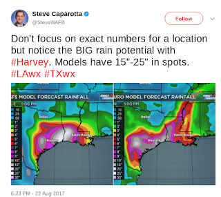
Either way the problem with the models is that intensity forecasting is not their sweet spot. They often either under perform or wildly go overboard. Models suggest over a foot of rain in many areas and one model puts out a crazy "build an ark" scenario of 18 inches of rain... and talking about areas prone to flooding such as the Bayou (pretty word for SWAMP) city Houston and New Orleans with it's broken pumps.
And remember when making jokes on the GFS..
...it did pin point where Invest 92L is now.
And that end game may still verify.
Going out to do somethings while I can before it gets busier. Looking forward to that cold front in the Carolinas, however that front is in the Carolinas not Texas and the steering currents be real weak... so until they get their act together both Harvey and 92L will dawdle round doing their thing on their own time line while forecasters across the SE feel the need to pull their hair out. Oh and trackers and on air mets are on their way to Texas for coverage of Harvey and landfall.
Besos BobbiStorm
@Bobbistorm on Twitter.
PS... for those long reader types who made it all the way down here... there is a wave off of Africa. This is the pic I call the Tropic of Cancer image. You can see Harvey trying to close off and you can see the wave near Africa currently being ignored by the NHC however the models are having fun with it... so soon we should have an Invest there as well. I know St. Peter says never say "should" but since when do I listen to St. Pete? Huh?
Labels: 92L, bobbistorm, Cantore, Florida, GOM, harvey, Houston, Irma, Manet, Miller, Mississippi, models, NHC, nola, spaghettimodels, Texas, tropics, ULL, weather, Zola


0 Comments:
Post a Comment
<< Home