A writer and a tropical muse. A funky Lubavitcher who enjoys watching the weather, hurricanes, listening to music while enjoying life with a sense of humor and trying to make sense of it all!
Tuesday, March 26, 2019
Tropical Cyclone Iba Off the South American Coast Near Brazil. Rare South Atlantic Storm.
That's the coast of Brazil.
It's not China and it's not South Carolina.
And that's Iba...
Tropical Cyclone Iba.
Unless you are a real tropical cyclone person...
..you probably didn't hear about it.
It doesn't show up on the NHC main page.
It says nothing going on in the Atlantic.
I guess they mean North Atlantic..
There are a lot of basins to be fair.
And though not unprecedented it's rare.
2019 Storms ... NRL doesn't show Iba.
But Iba is there none the less.
What's interesting to me is to look back over other years that produced a South Atlantic Cyclone and to see if there are any similarities we can see between this year and that year. This is the time of year when all the mitigating factors that contribute to hurricane development in the Atlantic Basin are studied to see which may be factors in the particular hurricane season.
Everyone online has been watching models.
Mike is always watching the tropics.
Models are hinting at development of a Low.
But that low is not likely to get a nod from the NHC.
The NWS will be issuing any necessary watches and warnings.
High surf, wind at the coast...
Who can say .... it hasn't formed but seems it will.
Rob's Crown Weather Services is a paid service.
He issues daily reports.
It's worth noting he's been talking on it for a while.
And DaBuh who never let a good wave go to waste....
...has been watching and posting online.
You definitely want to follow him if...
1) you do tropical weather
2) you live near the Florida or East Coast
3) if you surf anywhere near those beaches.
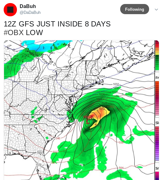
#OBX Low Pressure....
Very possible.
Each new system has followed a similar set up.
Back here to the Carolina coast.
Interesting how there was a large front and then....
..a small mini reflection here shown to the Wouth of it.
As we move deeper into the 2019 year....
..more fronts will fall apart and dangle off the SE coast.
They will need to be watched carefully.
Dabuh has been watching water temperatures a lot lately.
As in daily watching important areas with early development.
The water off the Yucatan is hot enough to boil eggs..
..okay it just feels that warm.
Bathtub Warm.
Early season development likes very warm water.
When the air temperature is in the high 80s in the Florida Keys.
And when the Yucatan is this warm.
Trouble is likely to happen early.
There are a lot of maps on Spaghetti Models.
You might want to scroll down and look around.
They could become useful sooner rather than later.
Just because there's no tropical updates from the NHC...
...doesn't mean there isn't weather in the tropics.
UPDATED!! Invest 90L Stands It's Ground 50% in 5 Days ...Orange Like the Lava. Beach Washout Likely Memorial Day Weekend For Many Beach Vacations. Is Alberto Going to Form Before June 1st?
Update as of 7 PM Tuesday.
Chances for development over the next FIVE days are now up to 50%. Currently because of interaction with land and strong upper level winds development is not expected to happen for a while. In about 2 to 3 days when Invest 90L has lifted up into the very warm Gulf of Mexico and if the forecast for reduced shear verifies than it has a chance to develop; actually a 50/50 chance of developing. Not it is currently a broad area of spin and you can see signs of that spin on both sides of the Yucatan. This is not very organized, however it has potential.
My advice is sit back and wait to see what happens when Invest 90L lifts away from the Yucatan and finds it's actual center, gets it's groove and the models will be more reliable after having a definitive center. The models are pretty good currently, however it's better to try and find things with the light on then stumbling around in the dark.
Again currently the concern is for the flooding rains vs whether it becomes a TD, TS or Subtropical Storm. Look at that moisture plume sucking up deep tropical moisture and depositing it over the SE and the Mid Atlantic. Then check out the feature to the NW of our Invest digging down and well keep watching as in a day or so you will begin to see the drama. It's like a Soap Opera in that in the beginning the writer's toy with the script (and history) and it doesn't make any sense, but like geometry if you keep watching, studying it at some point it begins to make sense.
Be glad this is a mushy, messy Invest.
Not a WNW bound Hurricane.
If you are impatient and want to see something happening now... feel free to watch the video of the Hawaiian Volcano with the colorful dancing lava fountain in real time. A bit concerned personally about the lava flow that has already flowed onto the property of the power plant. I'll take a hurricane any day, but it's mesmerizing still the same.
***
To be clear.
There is nothing there now.
A small kink in the force there.
Up close.
This is a watch and wait day.
I know I say that a lot.
The models have been calling for development and it's not just about the models there's obviously something there that keeps spewing up moisture and bursts of convection. To be honest the models won't stand down . . . they are standing their ground. Time will tell if this develops where the center will make landfall and more likely where ever this makes landfall be aware heavy rains can be displaced far to the right of the actual track. This happens often with early season and late season systems when conditions are not 100% perfect but allow some development. Remember back to many a big, large subtropical sort of system in the Gulf of Mexico leaning right. And, often what starts out as a subtropical becomes tropical. Only time will tell and that's the truth. But, what is worth noting is we are where we thought we'd be this season that is forecast to be a busy season and possibly starting early. The graphic below shows the real story and the scope of the story across a large area.
That's a shield of moisture.
A water world.
From Nola to Miami.
Includes the Florida Keys.
Spoiler Alert.
And this moisture spreads North after 5 days.
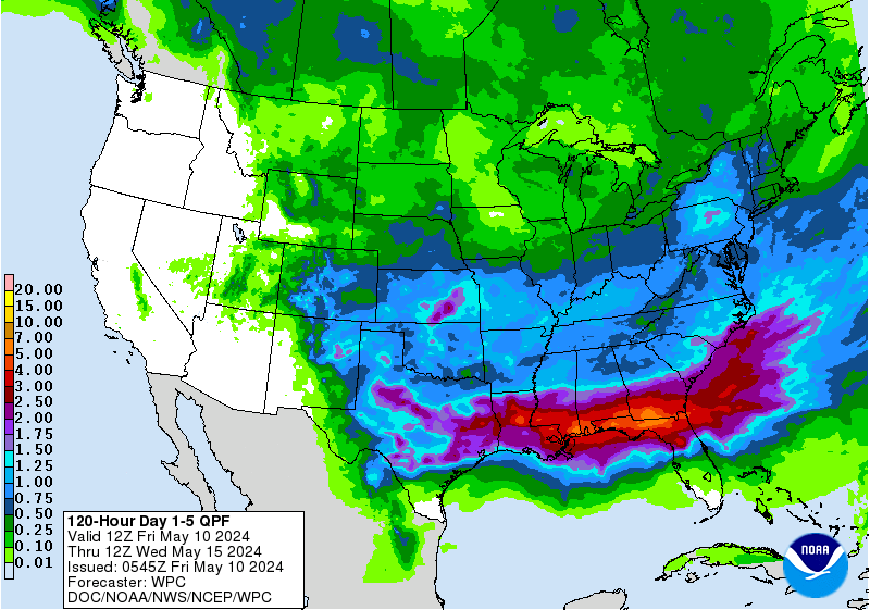
What this basically means is Memorial Day Weekend may be a wipe out for most of the Lower South and the people who make their living from the tourists and local beach goers will be coming up short this summer. Hopefully they can make it up as we move towards July 4th but this will put a big dent in the local economy wherever it goes. I imagine Malls and bars will do a brisk business. Which beaches you ask? That's the big question that the EURO and GFS are currently debating. As always until something actually forms, wraps up around a defined center long range models are weak indications of what will really happen.
The point is that is a forecast map by NOAA that is used by forecasters and updated often as things evolve, change or develop. You can't ignore it, but you can take it with a good measure of salt and be very aware the WEATHER may be on the East side as dry air will be a problem on the West side. So we could get a Tropical Depression or Tropical Storm Alberto that is aiming at the Upper Gulf of Mexico beaches but causing flooding along the West Coast of Florida. What about timing? Does it move fast or slow and when it gets where it is going will it become an unwanted guest that doesn't want to leave? If it leaves will it move North towards the hills of Alabama and Georgia into Tennessee or will it hook right and slide on up towards the Carolinas bringing those beaches more stormy weather? This system may be an equal opportunity beach vacation trouble maker. This weekend might be a good time to go to the movies.
Note even now...
..the convection is strong.
But displaced from the "center"
Or the X the NHC put up.
Either way the models won't back down and it's obvious there is something down there that wants to grow, expand, develop and move North with the overall flow. Dry air on it's West side is a problem and shear is still an issue. This strong tropical flow coming out of the Caribbean won't back down and neither will the Volcano stop putting on a beautiful light show that's causing misery and gobbling up houses as lava fissures ooze up out from the core of the earth and roll down the hillsides. It's all about being caught up in the flow be it a tropical moisture feed or a lava flow that flows all the way to the ocean.
Besos BobbiStorm
Ps.. I'll update during the day if anything becomes clearer but again where it develops, where it goes (does it cross the Yucatan or Cuba or slide through the Yucatan Passage?) and what happens when it gets there is the big story in about five days time. Now is a good time to look through that Hurricane Supply Shopping List, dust off the generator and figure out how many batteries you need for all those things that make life normal when the lights go out. Check out that water temperature chart below, shows how much available heat/energy there is for storms to keep firing up and remember location is everything. http://www.baynews9.com/fl/tampa/weather/tropical.map.html/
Watching Caribbean. Buying Cheesecake. Rainy Weekend. Long Term Models Show Tropical Problems for Memorial Day Weekend. Take Them With Mucho Grains of Salt Until Something Forms. But Something to Think On...
The loop above shows today and the near future.
It's a reliable forecast.
What is and what will be.
Everything else is conjecture.
Speaking of conjecture and his cousin innuendo there is much discussion about possible development in the tropics Memorial Day Weekend. We are getting closer to the point where we can say "expected" development as Memorial Day Weekend gets closer to the 7 day time frame for forecasting. The flow of moisture coming out of the Caribbean zooming up into the Eastern half of the continental United States will continue unabated for a few days.
Memorial Day Weekend is the official start of Summer for many, at least in the fashion world, where people change over their wardrobes and feel they are allowed to turn on the AC. I never get that AC thing as in my world black sandals work anytime and if it's hot I turn on the AC or as we used to say growing up in Miami the "life support system" cause you really can't live easily in Florida all year round without AC. But this Spring after an unusually long winter we skipped Spring and dove right into Summer. Meteorological Summer for those with no patience to wait for the Summer Solstice begins June 1st in tandem with the Atlantic Hurricane Season. And, right on time we have a system in the Caribbean that may develop just on time for networks to hype up the season and kick people in the ass to get out there and go shopping for much needed hurricane supplies. Mind you I'm talking about people not in Florida or the general Houston area who know the drill really well this particular year. If you live in the the rest of the Gulf of Mexico or the Mid Atlantic you may want to dust off those To Do Lists and Shopping Lists.
In the South Florida area there was much publicized flooding from locally heavy rains as the Monsoon Season kicked into gear. Understand places like Davie and Parkland were built far out into what was for most of Planet Earth's time history the EVERGLADES aka Swamp Land. And the better communities are built up a bit and have drainage ditches and drains that make the situation better. Poorer areas where the trailer parks are situated often do not have such luxuries. Note even with the luxuries when it rains that hard (it's called MONSOON for a reason) it floods briefly. I am concerned if something does develop in the Caribbean and moves up over Florida over an area that has been dealing with localized flooding for days we could see a much larger flooding problem even with a weak tropical system. Further up the coast areas in the Appalachia or the soggy Southeast they could also have long term flooding concerns if the current models continue showing a tropical system coming up out of the Caribbean making landfall and moving inland. May storms out of the Caribbean are often weak, however they are filled with tons of tropical moisture. Cold fronts this time of year show up but sometimes they don't grab the storm and slide it out to sea so fast. It could be a tricky set up.
That's not a dress rehearsal though it is a pretty dress she's wearing. TWC is dusting off their Tropical Update early while discussing all that moisture down in the Caribbean. So where do we stand today regarding the tropics. The moist tropical flow is zooming North bringing rain. The Atlantic is still too cold. Nice waves coming off of Africa early and too low, tho some of them make it across and add moisture to areas of moisture already in the Caribbean.
You can watch the flow below.
I just don't want to talk models currently as the models are long range and they vary, however they are coming together showing something trying to develop as moisture wraps together and moves towards South Florida, up over Cuba somewhere near the Yucatan and where it goes no body knows for sure. We also don't know what it's strength will be if it develops it's Northbound with some variation to the left or right in it's track. But although it may be raining this weekend in South Florida I'd enjoy the rain, do your thing and have fun because next weekend could be a real rain out if you were planning a BBQ at the beach. As Mike says you can swim in the pool in the rain anytime, so backyard parties are good as long as you are cranking up the AC inside and have a covered patio to lay out the food and beer.
As I said yesterday when all the models are screaming "SHARK!" you can figure there is some sort of big fish in the water. Time will tell how big, how strong and if it gets the name Alberto or not.
Here are some relevant Tweets posted online as they leave you with something to think about. If you follow Dabuh over time on Twitter or at his website you learn the method in his musical madness. Works for me.
As for me I'll be offline this weekend for a long but fun Jewish Holiday known as Shavous or as my friends like to tease me "oh that's your holiday where you eat cheesecake!" and that's true too. Lots of new fruits, desserts and a heavy emphasis on dairy and cheese dishes mixed in with your regular chicken and meat dishes at different meals. We also will be surviving Ice Cream over Cherry Pie and my daughter is bringing chocolate and cinnamon cake that is like a long, danish cake basically. I keep it simple with Greek Salad, Blitzes, Turkey, Chicken and Rice, Lox and Bagels for various meals. I may be making Fake Bacon (beef, it's good) Gourmet Burgers and fancy potato salad for a meal. Time will tell much like the modeling for the big Memorial Day Tropical ??? as things evolve in real time. I go shopping, I buy the ingredients, some show up from far away and then we'll see what mood I'm in Sunday Morning to see what I actually make or bake!
So until I'm back on Monday please refer to Mike's www.spaghettimodels.com for all your tropical needs and be aware if you like NASCAR he's there too so he's really got you covered. Again I'll be back online blogging sometime late Monday well rested and ready to rock and roll with the punches for whatever may develop down in the tropics. http://www.spaghettimodels.com/raceday
Also much of what may or may not develop down in the Caribbean will depend on what happens with regard to the shear. If the shear lessens as it is forecast to do so then something begins to wrap up into a designated system more than just models fantasizing as they often do this time of year. There are great shear maps on Spaghetti Models so make sure you move around throughout the site to fully actualize all the information he put there for you to utilize!
The models are up at the top on the left.
Take them with a lot of salt.
Like margaritas ;)
Besos BobbiStorm
@bobbistorm on Twitter
Ps. Should I make a Margarita Cheesecake? Hmnn. Again I'll be back at my particular harbor sometime late on Monday and until then keep listening to the music and watching the tropics. There's a Key Lime Cheesecake there. Works for me.
Updated! FRANKLIN and Discussion on 99L Models ... Eye Like Area Trying To Form. Convection Wrapping Around the Center. What's Holding It Back? Will It Pull Together & Do the RI Dance? Hurricane? Needs to Better Align First. Oh and 99L... and the ULL. The ULL is the Big Player Here!
Little late night update here.
First off not much has changed with Franklin.
Nice form, beautiful bands but pressure isn't dropping.
The wind arrival time is shown above.
Note this relates as to when it gets into the BOC.
Where it is forecast to strengthen.
NHC is talking on possible hurricane strength in BOC.
And we are watching as the center moves towards land.
Parts of the whole package, Franklin's weather is over the Yucatan.
Understand that as the NHC talks on landfall of the center.
Parts of Franklin are already entering the BOC.
It's a big round system ...
We track the center.
But there is weather in the whole envelope.
I promised some discussion on 99L
It's really not important today what the NHC shows regarding it's chances in the next two or five days of developing. It's a mute point in ways and sometimes it's good not to get lost in the details. 99L is a wave that was large and stayed together longer than most. 90L was a wave that didn't develop and then became Franklin. So keep that in mind while worrying the NHC might drop it for a day or so.. or not.
Originally the GFS was in love with this wave and gave it high odds in the short term for development. All the money was on this wave to become Franklin. The EURO however never liked it and barely showed any shred of evidence that it would even last this long. The EURO from day one was all over the Yucatan Solution for Franklin. And, as often happens, the EURO won that shoot out with the GFS.
The GFS slowly began to back away from the let's cream the East Coast scenario and eventually dropped 90L altogether from developing. You could see the convection that was left from 99L in the models and the NHC began dropping the odds. Not because the GFS ignored it as much as it did not develop and looked worse by the day. But it stayed there, it hung in as SAL ate away at it's huge pouch of moisture. And then the EURO noticed it and ever since the EURO has developed it and brought it close to the East Coast. We are talking long range models outside the five day NHC map I said to ignore.
The GFS develops a Low around Jacksonville exactly where Julia formed (it must have liked her) and takes it up along the coast but off shore. It's worth noting it is slower than the Euro. The image below is for August 17th and again models change in real time so nothing is set in stone ever.
On August 14th the EURO has a closed system below.
Off the Florida coast East of Jax and Daytona.
And it moves up the coast very close to OBX.
Carolina bound sort of..
So now what does the NHC do?
Ignore the golden child from Europe?
Ignore the whole thing for a few days?
Lower odds, raise odds?
Or just leave a 10% yellow circle?
A wave that does not die from adverse conditions and makes it across the ocean needs to be watched. Especially coming off of last year when storms refused to form until they crawled up onto the beaches of Florida. Upper Level Lows have been vicious this year as they were last year and this could be a similar set up as last year and either way... you just gotta watch. Time will tell. But do not get lost in the colors the NHC Is showing for the next 2 to 5 days, because the big concern may be in a week's time. If the EURO continues to show 99L developing it's something we will have to think seriously on in a few days. As always watch the system as much as you watch the models. Go to www.spaghettimodels.com anytime you want to see the models fast. But please watch the set up, the loops and the discussion put out by NHC. Every six hours they update their tropical discussion for the Atlantic. It's worth reading while looking at a satellite image of the Tropical Atlantic.
For the next few days Franklin is center stage. The nicest looking Tropical Storm this year.
AGAIN... a good part of Franklin..
is over the Yucatan.
But the winds, the core is not.
Nicely wound system.
Below you can see the winds.
Tight, compact...
..and far away 99L shows up for a change.
Been hard to even find it.
Still has a pulse...
Keep watching.
Sweet Tropical Dreams,
BobbiStorm
Updated image of Franklin you can compare and contrast.
An eye like feature is trying to pop out.
More so the banding had kicked up tremendously.
This has the shape and should make hurricane.
It's a wait and see situation.
Recon is what we are waiting for.
And recon is in on it's way and in the storm.
What looks like an eye popping out is not officially a center or an eye. The shear has lessened and the convection is beginning to wrap around the center. The eye like feature is a bit to the NE of the actual center. Unless recon gets in there and decides that the center has relocated under the stronger convection which sometimes happens. For now it's a watch and wait. When shear lessens and you have a beautifully formed system properly aligned watch out things happen fast. I'll be back shortly with the next update soon.
Tropical Storm Franklin.
Sitting on the ledge of Honduras.
Aimed at the Yucatan.
Looks good.
Note the convection is displaced to the East of the Center.
Put Franklin in motion and you can see what it going on.
The greens in it's rain shield are showing nice.
You can see how wrapped up it is on most sides.
Beginning to pump.
So what is the problem?
Why does it only have 60 MPH winds?
Looks like an eye should be popping out soon...
...still a 60 MPH TS.
Because it has an inner problem that needs to be fixed.
Shear has been there.
Shear is expected to lessen.
So I want to explain a few things here briefly as I will update later in the day. Shear is expected to be less closer to the coast. I don't need to put up lots of shear charts either you believe me or you don't and if not I guess you're here for the music :) Seriously the NHC starts off their 5 AM discussion with a long, defense of why they upgraded this system despite having a poorly formed center or a center that is there but very shallow and not easily discerned. They went with the upgrade at 11 PM when there was no signature on Earthnull and I didn't go there as really Earthnull does not replace a dropsonde dropped into the system. It's a tool we use and a good one, but nothing more. You can see below the discussion that the Earthnull signature looks much better this morning. I asked last night if there was a west wind and again remember the REAL center of Franklin is VERY close to land. The bright red swirling ball is off to the right of the center. Please read the discussion below I highlighted in blue from the NHC. Note I'm putting both discussions here. The 10 AM first and the earlier one below. It's good to see how things progress with regard to forecasting a tropical storm. Again note the discussion on the possibility of Franklin getting set up for possible intensification... maybe even rapid intensification.
Note in the newest discussion they talk on recon.
Obviously they need to find the west wind.
Pin point the exact center that's been hard to find.
The convection is easy to find.
Below they defend the 11 PM call on Franklin.
Note my tweet from earlier on Twitter.
This is why they went long with the discussion on the center. There's a question on the center. This has happened since time began with systems near the Yucatan. Of late the NHC has erred on the side of caution by wanting to issue advisories for an area rather than wait for them to hit that forecast sweet spot and have them suddenly form and eye and go through rapid intensification just before landfall. The whole purpose here is to give the public the most lead time with a reliable forecast. At the same time we don't upgrade to even a tropical depression without a closed center.
Next I'm posting the second part of the discussion as it relates to Franklin but also another wave in the Caribbean and whatever is left of 99L in a day or so. There is a large Upper Level Low that is parked near Puerto Rico and if it's there any longer PR should start taxing it. It's location with regard to Franklin has helped it breathe, given it that beautiful curvature you will see below and may aid in a more rapid intensification down the road. The same ULL is killing off the waves to the SE of it by shearing them. Seems the ULL can't do two things at the same time and is actually ingesting some of the moisture from the wave to the SE of it. Go figure. Again watch the trend as the newer forecast shows Franklin being 70 MPH again and again the NHC is conservative usually.
Forecast to be 70 MPH in 12 Hours.
5 MPH more and it's a hurricane.
Can TS Franklin do it?
10 AM they are back to 70 MPH as they were last night.
You can see the 5 AM below.
Earlier at 5 AM they pulled back on that.
Now they put it back in.
Confidence is not strong.
But the potential is there.
5 AM is shown below with it topping out at 65 MPH.
Always watch the trend in forecasting.
There is more confidence at 10 AM than at 5 AM.
Again it's worth understanding that Franklin could become a hurricane easy enough. Won't take much as the set up is there with warm water and low shear, but it's near the coast so it may run out of room. Should Franklin do the deed and become the first hurricane of the 2017 Hurricane Season than winds will be a problem so stay tuned. Rob from www.crownweather.com does feel it will become a hurricane as many others out there. But the NHC tends to be conservative but after they get recon in there ... their discussion and package may change. Quote from Rob highlighted below.
Here is Franklin on the WV imagery. Looking beautiful. Looking like an eye might pop out. All the shape, form, curvature and some banding trying to happen. So close to land.
Zooming in
Again remember the center is to the LEFT.
The deep convection is NOT over the center.
If they align better watch out.
The current cone is shown below:
Not much has changed.
10 AM Cone
It's worth noting it is crossing the Yucatan at the widest part.
The Yucatan is flat so that helps it.
Often they reform as soon as they hit BOC.
And shear is forecast to be light there.
So the chance for Hurricane Franklin exists.
Again at 5 AM they pulled back on long range forecast topping it out at 65 MPH. At 10 AM they went back to the 11 PM advisory from last night when they showed it topping out at 70 MPH. I'm going to leave them both here up above so you can compare. At the top I will update with the 1 PM later. It may seem like only a five mph difference but it shows the confidence (or not) that the NHC has in whether Franklin remains weak or intensifies close to hurricane strength. When I was sitting in my living room living in Miami Beach and John Hope was excited that Andrew had dropped 5 mph and was no longer a Cat 5 he was really excited. To me living 3 blocks from the ocean I wasn't too excited about a 5 mph wind reduction. But when they put it into their forecast for the long term it shows what they are thinking and their confidence or lack there of with regard to the future intensity of Franklin. It's worth noting what they do not say and that is the rain is already happening across Central American and Mexico as I type this and yet we are always focused on landfall with regard to the NHC product. The reason I didn't show the graphic for when the highest winds will arrive is because at this point the issue with Frankin is from flooding, heavy rain not wind. Again look at the convection to the right of it's center shown above. It is a very wet, huge tropical storm. And, again it formed from a tropical wave that did not form due to SAL and then it did. Remember that with regard to 99L and the waves behind it.
Bottom Line:
The trend is important to watch.
Going wide with the loop above. You can see the ULL. It looks like a black inverted tropical storm. Moisture has gotten trapped inside.
If you are on the friendly side of an ULL it is well...your friend. It helps you develop. But if you are on the unfriendly side of an ULL it tries to kill you off. And that semi permanent ULL has been killing off the waves all season so far.
I don't want to go deep with regard to 99L now.
But I'll discuss it later today in depth.
More the various waves moving West.
For now the show is Franklin.
Truth is stranger than fiction it seems.
We have a Tropical Storm ....
...but we can't be sure there's a west wind.
But what do they got to lose?
Give warning to an area in it's path.
And with some forecasts of rapid intensification.
Why the things we do?
It is what it is.
This is what we do.
We like to give a heads up and warning.
Note the models are up at Spaghetti Models.
I'll go longer on 99L later.
And the wave behind 99L
Again remember Franklin formed from a wave...
..that formed later rather than sooner.
Close in.
Til then enjoy the words and the music.
Besos BobbiStorm
@bobbistorm on Twitter
Ps...Again I'll be updating throughout the day so check back in.
Remember when waves have problems forming...
..and storms cannot align it looks like a "crappy season"
Location: Miami, Raleigh, Crown Heights, Florida, United States
Weather Historian. Studied meteorology and geography at FIU. Been quoted in Wall Street Journal, Washington Post & everywhere else... Lecturer, stormchaser, writer, dancer. If it's tropical it's topical ... covering the weather & musing on life. Follow me on Twitter @ https://twitter.com/#!/BobbiStorm