A writer and a tropical muse. A funky Lubavitcher who enjoys watching the weather, hurricanes, listening to music while enjoying life with a sense of humor and trying to make sense of it all!
Wednesday, June 12, 2019
UPDATED THURSDAY!! Tropical Waves Coming Off Africa... Flooding Summer Rain Closer to Home. Could Anything Develop? Officially NHC Says No But Lot's to Watch.
Publix has a lot of good buy one get one free specials today.
Juices. Baby Wipes.
Things you will need during hurricane season.
With strong waves such as these above...
...and stalled out fronts near North Florida....
You should be shopping now!
Making lists.
What do you need to do if a hurricane comes your way?
Or pops up off shore from a dead cold front?
I'll update later today about record heat and rain...
...and why this should concern you.
ciao for now...
be back later.
Please read if you have not done so already.
Thanks!
Today's post is regarding waves over Africa.
And much action close in that I'll discuss later.
There has been much discussion on early African Waves.
You can see our latest pair coming off today.
There is African Dust known as SAL to the North.
A huge high more discernible on Water Vapor Imagery.
What you also see in the above image is the shear from the Caribbean...
East bound towards the Atlantic.
So if there is shear and there's SAL why are we watching the wave?
Honestly it's a kick ass wave for any time of year.
And though it's too soon in June this June has felt more like Mid July.
It's not totally impossible for a wave to find a way to stay together.
It happens.
It happens rarely.
I was asked online if it's a a "frightening glimpse of things September has in store?" from a good writer and a long time online friend. I'd agree except that this June has been like July in many ways so I'd say it's a glimpse of what August may bring. Yes, we do exaggerate early waves (his words) but my response is two fold.
There is always some wrench that crops up in the tropics regarding what seems to be perfect, positive conditions for tropical development. This time of year we have shear coming out of the entrance to the Caribbean that blows apart kick ass waves. We have a strong high that sometimes propels them too fast yet this year they have made it across the Atlantic and washed up onto the shores of South America still noticeably held together enough to have been able to track a wave's progress the whole trip from Africa. This is something we do and something we enjoy tremendously this time of year and when you get bonus waves so well formed and nicely spaced apart it's more enjoyable. Especially enjoyable knowing nothing is going to slam into the Islands protected by the Shear Zone and the water is not warm enough to support real formation so it's just a fun thing to do and on some level yes it shows how patterns are developing. The reason nicely spaced waves is important is that some years they come off too close together and rob each other of moisture competing for supremacy and they all equally lose and have problems developing. The well spaced waves are more prone to each have their own zone, their pocket to develop in if the other conditions are favorable. And, how they look early in the season is usually how they look and come off in another month down the road closer to East Atlantic development as they roll off of Africa over a beach in Senegal with a low pressure system attached. Again that is what it means to watch the patterns.
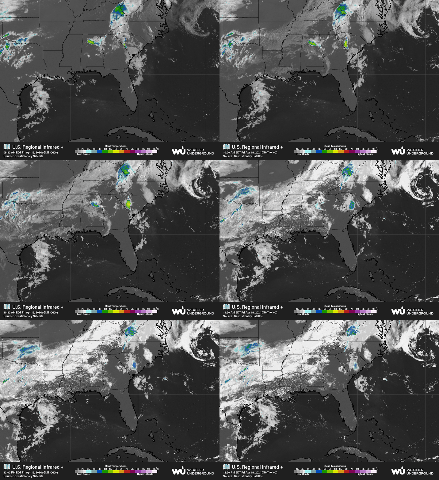
So we are wave watching. What I am also watching is the consistent, persistent congregation of moisture off the SE coast on both sides of Florida and close to Georgia as fronts keep on coming and then falling apart into a stationary front and linger too long with nothing to push them out to sea totally. The water off the Florida peninsular is warm and along areas of the Georgia and Carolina coasts it's warming up fast. Sometimes things "pop up" as I wrote in my previous blog.
Note that blob of rain that moved from GA to SC.
And now is off shore.
Every day Miami is getting slammed with storms.
And check out the mess that came off of Texas.
These are your usual regions to watch in mid June.
I'm watching.
But right now they are all just clouds.
Clouds and convection.
Blasts of shear shooting across the ocean.
Moisture in motion.
Note yesterday.........
Up to 7½" of rain and flash flooding in south #gawx from this circulating cluster of nearly stationary regenerating thunderstorms pic.twitter.com/gxYpVSJHDB
Crazy Huge Hail in North Carolina. Yes Size Matters... Cool Weather This Morning. Nasty Weather on the Plains... Then Comes Hurricane Season
To be clear...there is no hurricane today in our basin.
There isn't even a small tropical storm.
Not even a tropical depression.
Yet I'm a really good mood.
Why?
Is that awesome?
Okay it's a kind of denial but loving it.
Windows wide open.....
...fresh air.
Not hot, not humid.
And yesterday I got hail.
Big, huge, hard hitting, heavy hail.
This is a video from online.
Crazy fast hitting hail storm.
This shows why I don't have good video.
I was out in it in my husband's car...
...he really didn't want the hail in the car.
But he was fantastic about going out into it.
And he drove through a heavy white out while...
I was over the top crazy excited loving it.
I love hail.
I don't love hail to destroy your car or crops.
Just something about hail... it's crazy.
So the day began like this....
It was extremely dark outside for 9 am and despite warnings the last few days that we were in for marginal chance of severe weather nothing loomed big on the radar but the air had that feeling to it so I went outside. The sky was heavily cloaked in low, dark clouds. My phone announced a lightning strike hit about five miles from my location. I took a walk, tried to get a feel for the weather without staring at the radar or playing online with friends. I wondered on the man edging the lawn, gardeners out doing their thing with threatening weather didn't seem like a good idea. They were picking up lots of debris from the last late night storm and doing a nice job but using edgers with earphones on listening I suppose to loud music from the way the guy was enjoying himself seemed like flying blind into nasty weather. Suddenly there was this huge, jagged lightning bolt that cut it's way across the sky not far from me at a long, slow angle and then suddenly sliced down with an explosive sound that I'm guessing landed a few blocks away by Ravenscroft athletic field; nice private school with a huge athletic field filled with huge lights that often attract lightning or ravens... depending on the weather.
My husband yelled downstairs and asked me if that was lightning. I yelled up "yeah" as my heart was suddenly beating fast and he yelled down "good" because honestly otherwise you would have thought a bomb went off somewhere. Raleigh doesn't get lightning storms the way Miami does and so this sort of came out of nowhere. Not a dark, threatening sky but low, heavy gray skies. And then the most incredible downdraft began as the temperature dropped and the breeze began and you could feel that feel in the air. So we left because I wanted to be outside somewhere if we were going to have weather and yet I didn't expect it to happen so fast and again no crazy warnings yet but you could see the radar had a few fast moving rogue cells* moving fast towards me.
I took this picture and asked my husband if he wouldn't mind just going a few more blocks down to get a better view of the line and as usual he was agreeable :) so we drove another block or two and the whole sky just opened up and the wind began to blow and somewhere you could see a drop of rotation and huge, hard, heavy hailstones began pummeling the area. This system was moving faster than a bat out of hell as the saying goes and as I didn't want the hail all over the car I didn't open the window to get a good picture ... also figuring there were plenty of videos being taken I wanted to enjoy it. I did open the moon roof enough to watch the hail hitting before closing it as it was kind of making my husband concerned. Yes, the hail was that huge and more so voluminous amounts of hail not just one or two here or there as we usually see in Raleigh.
It says officially 1.75 inches in Raleigh.
I'd go with that but it really was the volume.
Trust me though size does matter with hail.
Wind was blowing wildly.
Total white out... could barely see the sidewalk.
Headlights in the white out that looked like thick mist.
And then it was gone.......
Within minutes a tornado warning was posted.
(Thanks....)
And I was nuts, excited and happy and loving it.
I do believe I said something like ... "Can we do that again!"
And we did but without the hail.. just heavy rain.
Cranky calls them *rogue cells.
Good term.
Fast moving rogue cells.
Going under the radar til the NWS played catch up.
A catch me if you can sort of rogue storm cell.
Further away it was rated EF2 tornado.
Lots of damage.
By us we had immediate flooding ...
....but it ran off fast.
Yeah I love weather.
As for the tropics nothing there now.
But this triangle area needs to be watched.
Down the road.
As long as weather lingers there....
Anything can happen in a few weeks.
I'll be back soon with more real discussion.
I just wanted to record my thoughts.
And I want to get out and enjoy the 55 degree weather.
It's an illusion but I'll gladly take it.
Later in the week it's supposed to be in the high 80s again.
Showing this image below as it shows how close the storm is positioned now and where her hurricane force winds are (dark muddy red) just touching the coast and the wider mustard of Tropical Storm force winds. The Hurricane Warnings go SC to the border of NC/VA. In truth it's a map drawn to give you an idea and understand hurricane force winds do not stop at a border and often extend North into VA along the beaches in squalls. Florence has always been top heavy and her bottom Southern side has always had difficulties maintaining itself. Even the eye wall on the Southern side last night was breached by dry air, but it mixed the dry air out and bounced back. Note in the short term the coast between NC and VA is getting pounded, in the long term she is forecast to crawl across the lower part of NC and through the upper parts of SC (or possibly jaunt down the coast a bit to see Myrtle Beach) and weather will go EVERYWHERE. So the map is a guide it is not a set in stone deity to believe beyond anything else. And, it changes in real time so if you go to sleep at 10 PM because you saw the cone at 5 PM you may miss any changes in strength or direction at 11 PM when they make major changes. Don't wake up and act upset you didn't think that was happening because you missed the 11 PM. Weather happens in real time and the NHC adjusts by degrees as needed. She can speed up suddenly or come to a grinding halt and move tediously slow dumping rain over the same spot for over 24 hours.
As for me I'm organizing (something Capricorns do often) and putting things in places I can find them in case the power goes out. It's possible, I have to know that, but I'm hoping we don't lose power. I cooked dinner for Friday night today in case I don't have power tomorrow or time. I cleaned, did laundry and moved some things away from windows in case I have a problem... But I'm not expecting a problem. But you prepare for the worst and hope for the best. I'm giving you an example. Keep your phones plugged in as much as possible at full power in case your power goes out and keep your power sticks full and somewhere you can find them. Flashlights, candles, medications all should be somewhere in an interior room where everyone can easily find them. Those are the basics if you live inland vs down at the coast where the tide has already risen and is flooding towns, beaches, stores and 2/3 of Emerald Isle is already out of power. Emerald Isle is a thin sliver of land South of Morehead.. it has a rough hurricane history and after Hazel and then after Fran in the quiet years people built homes like they never thought a hurricane would make landfall that strong again. I have friends who have homes there, it's their favorite place in the world. To me I prefer Morehead, Atlantic Beach and New Bern...and walking on the beach in Wrightsville and then going into Wilmington for dinner and to walk along the river and watch the sunset over the Cape Fear River. This storm is a watershed moment in my life as it shows me how much of a Carolinian I have become over the last ten years. Go Panthers!
Close up maps of the two areas currently under assault from Hurricane Florence.
This is what you need the battery operated radio for..
..to stay in touch with the world
Some thoughts from Twitter.
Always curious on what Cranky has to say..
So true what he said below.
The rest is mostly thoughts on my life in Raleigh today.
I'll be busy today preparing for what may be tomorrow.
I'll update later today after the 5 PM advisory package.
Dark and beautiful in Raleigh today.
Hurricane Florence now visible on our local radar and noticeable in ways in the air via the clouds, beautiful steady breeze and depending on where you live rain or drizzle, and rising water from the bays and inlets here that we call "sound" or "bouge" along the coast. To be clear I do not live by the coast, I live inland in the "Piedmont" where the land begins to rise but not near the mountains. Raleigh is the "in between" land, you can drive down to the coast for the day or up to the mountains though both can be a long drive depending on where you are going. In Raleigh this morning it's apparent the Hurricane is knocking on the door of North Carolina as the sky is heavily cloaked in dark gray clouds streaming in from the East and Southeast. There is a steady, beautiful breeze but not strong yet and drizzle is often seen in the air. I'm not used to that as in Miami you get heavy bands early on out in front of the storm, but here there is drizzle in the air and it looks as if it is about to rain but it just keeps fine mist drizzling.
So my thoughts are on past storms and communities of people who lived here in the 1800s and woke up to this weather and knowing it's not a normal pattern as cold fronts come in from the North and West and summer rain comes in dark and steady with thunder and lightning they had to know there was a big blow down by the coast somewhere. It must have been scary and worrisome as many people in Raleigh had family and business contacts in New Bern (the original capital of NC) and without cellphones or phones they had no way of knowing if their loved ones were safe. They also had no way of knowing how bad it was going to get in Raleigh as sometimes inland bound hurricanes came and tore trees out by their roots and knocked down fences, ruined crops and destroyed businesses; usually they don't make it up to this part of the state but when they do it's a long term mess. What did old settlers really know I wonder?
In Raleigh people are trying to squeeze work in today before we know for sure what tomorrow will be like. Parents are out with kids at parks especially near rivers doing what parents do before the storm... sharing a memory with their children of going out before the storm comes in.
The father walked the grandmother slowly down to the river.
The mother and the two little girls ran ahead.
And then they unpacked some food and sat a bit.
Raleigh is and always was a river city.
I was upset we didn't drive down to the ocean. I like to see the ocean before a storm to know what the storm is really like but I didn't want to get in the way of evacuation routes. When you have seen as many hurricanes as I have you can tell from the waves, surf and "the feel" exactly how strong the storm really is or how bad or easy it may be. Trust me on this... Sandy passed by Miami but it had a mean, cruel look and Floyd was one of the wildest oceans I have ever seen in Miami as it slid by us well forecast to by the NHC on it's way to creaming North Carolina. Andrew on Miami Beach was powerful, the sound of the ocean roaring like a jet's engine left on and without waver. So we went up to the Neuse River where we often go especially to do Tashlich a custom Jews have during this High Holiday period; any running water with fish it will do but we like to go up to the dam by the river where we often have picnics. Yes, we have enough gas for the short trip and yes it was worth it as it was very inspiring to me. Raleigh is here because of the river and on a quiet, gray day I could almost picture it as it looked years ago near where the mill was and where people lived before they dammed up the river creating Falls Lake. We could not drive up to the top for the view as the park was closed however people were walking up there around the closed signs. I had priorities, not hiking uphill for a long walk today. So we stayed here a bit.
So now I'm home.
This blog is powered by a Pumpkin Spice Soy Milk Frappe.
Sweet, delicious and perfect for the moment.
Note Starbucks is closing at 6 PM in Raleigh today.
They will assess the situation for tomorrow...
...later today.
The Dollar Store and Harris Teeter are open..
I'm home organizing, watching TWC where on air meteorologists are standing by my beaches and places we spend our time at often. Local news is on as well and I've got things to do. I'll be on Twitter all day but will do a long update tonight after the 5 PM Advisory package comes in and the next set of model runs come out. It's an odd feeling on air mets I know...at my beaches I love, watching from afar. I used to chase storms with others in Florida where we stood near the networks did their live shots before the storm... they often get moved up and down the coast depending on where the storm goes. Chasers move around a lot obviously chasing the storm, sharing important valuable data and taking video that is often studied after the storm for evaluation purposes.
So far not much has changed. Florence is weaker in strength, though still wide in size and still moving NW a bit slower but steady at 10 MPH. Will she stall? Where will she stall? Where will she make landfall? We know the 'who" we aren't sure on the when or where. Journalism 101 never goes totally away. Then does she decide to go for a jaunt down to Charleston as many up here do after spending the night in Myrtle Beach? People are prone to say "you wanna drive on down to Charleston?" and that's what we are wondering today regarding Florence's future track will she go West or slide south of West a bit? I'm not set on her going that far South but time will tell. Either way her storm surge spreads out like a huge fan in all directions as it approaches the coast so up in Virginia the tide is high and down in Myrtle Beach the water is rising as well. New Bern at the juncture of two rivers (one of my favorite cities) in the path of storm surge and they are prepared and waiting for it. Fayetteville may see more of the storm than many thought and I mean a good amount of wind not just rising water and evacuees filling up the motels from Down East. Down East is what we in North Carolina call the beach and bogue communities down east there by the beach. Core Sound and Bouge Banks.. inlets, bays with odd historical names familiar now to me and others who live in North Carolina.
Good graphic from a wise meteorologist.
Followed him for more years than I want to say.
Note all the tracks take this along the NC/SC border.
Most tracks avoid inland NC..
Time will tell.
We are waiting to see and prepared.
This is more realistic than the last few days.
Less of a dip and more of a due Westward movement.
If you read previous blogs you know I spoke on this often.
I think it's more likely it will go due West...
...vs SW but Florence will show us her end game soon.
Location: Miami, Raleigh, Crown Heights, Florida, United States
Weather Historian. Studied meteorology and geography at FIU. Been quoted in Wall Street Journal, Washington Post & everywhere else... Lecturer, stormchaser, writer, dancer. If it's tropical it's topical ... covering the weather & musing on life. Follow me on Twitter @ https://twitter.com/#!/BobbiStorm