A writer and a tropical muse. A funky Lubavitcher who enjoys watching the weather, hurricanes, listening to music while enjoying life with a sense of humor and trying to make sense of it all!
Sunday, September 15, 2024
Updated 4:15 NHC Issuing PTC8 Cone Forecasts This To Become TS Helene Before Landfall Near SC/NC Border........................Sunday Afternoon. I Should NOT Have Stayed Home For the Panther Game. Being Creamed By Field Goals... OMG. Watching Invest 95L Will The Real Gordon Stand UP???
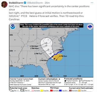
"signifcant uncertainity in the center...
...position ...best guess ... NW 7 MPH.
Wind probs range from Danville VA... Raleigh...Rocky Mount then stronger probabilities near the coast and inland towards Charlotte. In truth it's still kind of blobby and pulling together and conditions far from the center could deteriorate across a wider area while we watch Helene make landfall down near the SC/NC state line. Unless this really pulls together into a tight ball where weather would be concentrated but there is low confidence in anything other than it's going to do the Carolinas (North and South) and Virginia watch out. NHC does forecast PTC8 to become Tropical Storm Helene before landfall.
Glad they did... better they err on side of caution.
Below is from 4 PM
* * *
I Waited til 4 figured ok... FINE.
No Cone.
But I guessed wrong.
PTC8 Cone at 5 PM for Invest 95L
How bout that.
PTC 8 Cone.
Advisory. Good call ... I think.
Err on the side of safety.
Will update.
Keep reading my blue funk mood is gone.
Great song at the end really.
* * *
Not to scale perfect obviously.
This is obviously a hard situation to properly explain, but IR shows flaring up close to land over warm waters of Gulfstream ...there's been 2 competing centers for a while, wondering if they are coming together. Francine 2? Not just Francine, seen it a few times this year.
My concern is that every storm like this one, especially the No Name Storms but even the named ones someone dies at the beach...especially in off season when lifeguards not there as in summer... usually, but not always a tourist unfamiliar with local weather but not always. Often a father or relative goes in after a child and gets swept away trying to save the child that have so live with their father died trying to save them. Last storm 2 out of state tourists checked into hotel rooms and ran out to the beach, and never came back. Obviously a name heightens awareness of dangers, but not always and No Name Storms with conditions similar to Tropical Storms are even harder to explain to people who connect "No Name" with "NO PROBLEM.........." and that's always a problem.
Here in Raleigh enjoying having my windows open and watching small fast moving storms pass through fast, more like strong showers really. But it's that fast hit and run set up that makes it feel more tropical than frontal activity or just a steady flow from the South as a warm front backs up from SC to NC.
Not easy being NHC as everyone can access satellite imagery, models, radar and microwave and everyone has an opinion.
I wish there was some sort of Special Statement they could put out for Quasi Storms with No Names when they feel it doesn't warrant a name. And, don't say "we can hand it off to the NWS" becauase as much as I read local forecast discussion, I am one of the few I know who even check it and local channels do NOT rush to interview the head of the NWS for Raleigh or Wilmington or Myrtle Beach. Just the reality, just the truth ... sad but true, just the way it is...
But hey we got models :(
Models drew a heart ....
...aw how not really cute.
U can't make up this hurricane season.
I promised myself I'd stay on top of football. I love football. My Dolphins aren't doing very well and with Tua out last week, who knows what the future holds. A team with promise but promises are rarely kept and they lose way more than they should. As for Carolina, my new local team, I'll admit sometimes I watch Cam Newton on the top of Twitter doing his thing, having fun, being Cam Newton. Awesome player. But, there have been many players who have come and gone since he left and every season is promising, but promises are not kept. I need a 3rd Team.. I'm open to suggestions. I have narrowed it down to a few.
Easy to say what's wrong with a football team.
Missed signals, missed plays.
Too many penalties.
QB passes a ball that hits receiver on the numbers and receiver drops it. (no excuse for that... not really)
Poor Offensive Line can't give the new supposedly good QB time to throw the ball. Special Teams is out there but not making big plays. Too many interceptions or fumbles. Time of possession makes a difference, you can't win if you aren't possessing the ball.
I can go on and on and on...
Players don't connect well as a group and lack that feeling of TEAM Work.
List goes on and on and on.
But when it comes to 2024 Hurricane Season? Lots of possible reasons, lots to research and even when it looks like we know what will be... a wrench is thrown into it or a Cat 5 in early July hits an Island rarely hit by a hurricane.
Tell you one thing. In football I can read a coach, I can tell when the coach is just not on his game and I can tell when a team looks beat and lethargic.
Location: Miami, Raleigh, Crown Heights, Florida, United States
Weather Historian. Studied meteorology and geography at FIU. Been quoted in Wall Street Journal, Washington Post & everywhere else... Lecturer, stormchaser, writer, dancer. If it's tropical it's topical ... covering the weather & musing on life. Follow me on Twitter @ https://twitter.com/#!/BobbiStorm


0 Comments:
Post a Comment
<< Home