Tropical Storm Chris. Beryl Discussion. Maria in the Pacific Nearing China. Where's the D Storm. Tropics Busy in July.

2 Tropical Storms in the Atlantic Today.
How fast things change.
It's as if July the switch was flipped.

Beryl below:

Chris below:

This is really the big story today in the tropics.
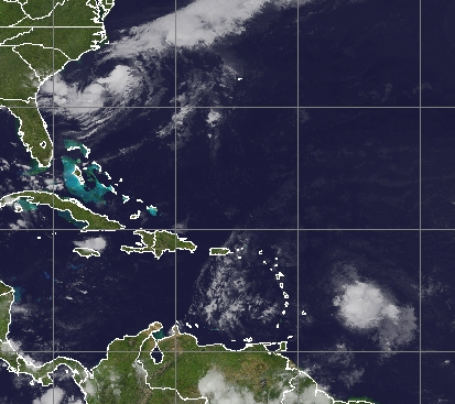
Tropical Storm Chris
Off the coast of the Carolinas.
Not moving much.
Looping about in place.
Maybe some upwelling...
...could be a factor here.
(that's true but a bit of an inside joke)
But it's my blog so I'll make the joke.
Not going to say much about Tropical Storm Beryl as in truth as much as it's been fun covering the sudden appearance of a tropical wave that did not fizzle the moment it hit the cool ocean and managed to swim through Saharan Dust to maintain Hurricane Status to be honest it barely looks like a Tropical Depression currently. It's clinging to life the way the children being pulled out of the cave are clinging to the tether as they try to come out of the cave in Thailand. It's a storm as of 9 AM but it looks more like an open wave on many sites. It IS a closed system and we are watching it. The islands are watching it as even weak systems coming through can spawn up some nasty weather.

Cone below.

There is much shear being shot at it.
The infamous shear at the gate to the Carib in July.
That shear lessens in August and September.
That's why we really worry on September Canes.
I'll update later today on Beryl.
One note on Beryl.
As small storms fall apart their weather goes wider.
That happens often and it's happening now.
Suddenly you can find Beryl easily on Sat Imagery.

As for Tropical Storm Chris off my coast.
It's a large area with a closed center.
It's a weak Tropical Storm currently.
And energy across a large area.

Note the CENTER is far from strongest convection.
This image from NRL explains it all.

The image above shows the story.
The beautiful blue color on the microwave imagery shown above is the cold, dry cold front. It's not really a COLD front but in contrast to the "feels like" 102 degree temperature Raleigh has had in the recent past it's like a coming attraction for Autumn. It's wonderful. And the high pressure to the North of Chris is trapping it as I said it would a few days ago. It's trapping it to the South and Chris is waiting for his chance to make his move. The real "center" is more in the green area to the North of the red orange areas with the most convection. Shear is blowing the stronger storms off to the South. But to be fair this is what happens with tropical storms that form early on in the season in this region. The winds are there not always where we would expect them and sometimes systems like this develop multiple centers where energy gets transferred around a bit as if Chris is playing soccer or kick ball more than doing real water aerobics or planning on going anywhere soon. And, to be fair Chris is basically just hanging out like a tourist who rented a house at Nags Head hoping to have a few good days to relax and enjoy life before entering the Rat Race again and Chris is forecast to do just that. Currently he is forecast to become a strong Tropical Storm possibly a Hurricane as he races North (eventually) with the next front. My problem here is I am extremely jaded on a second beautiful cold front coming down this far in Mid July. I'd love it, waiting to see it but skeptical.
Since I've lived in North Carolina (while not in Florida) I have interviewed many old timers who talk of hurricanes and more so tropical storms that lurched West and were not expected to directly impact the Outer Banks but did. Note the Outer Banks have a Northern Part and a Southern Part and the hit the nail on the head part known as OBX. Sometimes storms or part of the storm slip in on the SOBX and slice thru the area on their way North. Other times, most times, they stay out to sea but kick up the waves to the point where surfers really delight in it all while the news media constantly warns people to stay out of the water. Yesterday a man died in OBX being dragged out to sea. Hoping and praying nothing like that happens today..

There's a reason this bumper sticker looks like this.
It's also the 1st sticker I bought visiting NC 10 years ago.
10 years ago.
Crazy huh?
Below is the map of the whole Outer Banks

So this is the cone below.

I'm expecting Chris to stay out to sea.
But....
I feel like there is a sea of insincerity in the forecast discussion.
So I'll wait another day before I make that call.
Cranky on Twitter shows the track evolution theory.

Going out today.
Got things to do and things to see.
I'll update later today.
It's worth noting there is a new wave off of Africa.
Nice wave.
Healthy waves this year.
Remember I said that come August and September.
Understand keep this in perspective.
Beryl and Chris in the Atlantic.

Maria in the West Pacific Below.


So keep Beryl and Chris in perspective.
Where's the D storm?

Hope you all have a wonderful Sunday.
Besos BobbiStorm
Ps. The beautiful team work that is going on to try and save the lives of the young soccer players in Thailand should be a lesson for all of us. For us all to get somewhere in the world, to make progress in making the world a better place takes teamwork. Standing around constantly arguing with each other doesn't progress us much. It's good to discuss differences of opinion be they politically or tropically speaking but in the end at some point we need to come together and be one to thrive. Just my thoughts.
posted by BobbiStorm @ 7:01 AM
![]()


0 Comments:
Post a Comment
<< Home