Updated.........Sunday AM...Maria and the Carolinas... ULL Watching As It RETROGRADES West... Possibilities on the table..
Maria... distant Lee...
...ghost of Jose
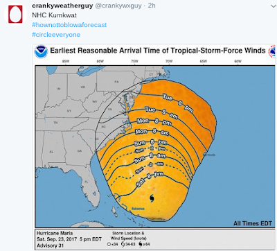
5 AM NHC Cone
Let's call it a blueberry cone.
Sometimes a picture...
..doesn't tell the whole story.
Let's look at Funktop.
Funky.
Flat.
Let's call this flat top today..
A curious mind would wonder...
....why is Maria flat.
Let's spin Maria...
 '
'
There's the water vapor loop below.

Only reason a storm goes flat.
Pressure is pushing down on it.
Maria should check her chakras...
Remember those sayings...
..people love to post on Facebook?
We have a hurricane that's in the Atlantic with no watches or warnings up currently and a long range forecast cone to go out to sea as it kind of blows kisses or waves at the Outer Banks. So why can't we enjoy watching Maria spin? Rather than enjoy watching her spin meteorologists fight over the outcome that is murky, days away and let's get real there are ONLY TWO SCENARIOS with any hurricane.
1... She goes out to sea. You can almost always bet money on this no matter what the models say.
2... She falls apart over land and rains herself out.
It's that simple so basically a 50/50 that usually with Atlantic hurricanes is weighted 70/30 or even 80/20 towards "out to sea" aka OTS. This changes obviously in the Caribbean or the Gulf of Mexico but almost always a hurricane goes out to sea. Sometimes it brushes land and creates problems along the coast and still goes out to sea... and sometimes a hurricane is blocked from going immediately out to sea and therein is the problem and why hurricane forecasting is so difficult. So difficult, especially when your pride feels threatened when you are even a little wrong every six hours. Models have no pride they just throw out whatever the result is from their inner calculations. Garbage in.. garbage out? Oh well..... check back on the next model run. If I wanted to choose between being a forecast and a model run I'd probably take the model run as they are more like slackers vs OCD types who can't seem to enjoy the party. So much for enjoying the journey.
Why can't we enjoy watching Maria spin the next few days and stop eating out corn on the cob before it's time to be picked? Not as sweet when you pick it too sweet, trust me. I mean everyone wants to be in High Cotton not Mediocre Cotton. There is no rush..........enjoy the beauty of Maria far from hitting islands in the stream and according to the NHC she's going out to sea sooner rather than later.

I'll update this after the next advisory package...
..and the next model runs.
And when I'm in the mood ;)
Cause I'm going to enjoy....
...a hurricane that isn't about to make landfall.

Check back later for updates
Bonus track....

I'm back... refreshed.
Watching Maria ...
From a NC perspective.
Catching up...
I watched this video twice.
Sometimes he's straight forward.
Other times he hints at things.
Twice makes it easier to catch it all.
Great update.
I watch the video while looping.
Helps.
Just take a look at Jose that caused power outages, beach erosion and ferries were cancelled as it looped off of Cape Cod.
http://www.necn.com/news/new-england/Jose-Continues-Moving-East-Cape-Islands-Still-Impacted-446353933.html is an easy illustration of what a looping, stalled out storm can do. Again St. Marys Georgia far from where Irma was battering the SW coast of Florida did historic damage to their docks. The longer a hurricane has been around the more impact it tends to have far away from the center. Much like Matthew pushed a dome of weather far inland into NC as the "center" retreated away from the coast.
And when it comes to NC Chick Jacobs knows NC weather. How much "wiggle room" Maria will get when it gets up this way is the big question. Not a lot is the answer though as weather is fluid that could change in that it could get more wiggle room or way less. Note my image below. The air around Maria to her immediate North is going towards land, the weak front is moving about and air is riding up over it far away and somewhere in there a high can set up. And, that explains why the official cone has Maria ip toeing along slowly. Let's be honest, she's never been a fast mover and if she had she'd be on the road to out to sea by now.
Watch the loop below.

See the high pushing down.
Look up N of Virginia.
Into Kentucky.
The bubble of moisture pushing inland.
Watch the close up view of Maria.

Maria has been leaning Left for a while.
Often that shows us where she wants to go.
Down the road.
Just one view.
The ULL is retrograding West.
Weak Lee is doing his part.
Out there weakly.
Ridge behind Maria holding.
May stall.
Over warm enough water.


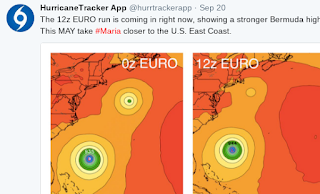
Gotta watch those old model runs sometimes. We toss old model runs out fast. Like an old boyfriend in favor of a new hot guy. We have become way too fast too leave a good model run behind in the dust because the next model run swings right or left and then there's the NHC that never saw a model it could trust even when it's their favorite EURO. I mean they have been very verbal of late that EURO is their boy and yet................ they are slow to go say yes to going all the way with the EURO so we watch them all... and that includes the Canadian and the old new named UKMET model and after a while we stop reading Discussion and start discussing the models online. And, that's good cause there are some incredible voices online on Twitter and other places that go deep in discussion where others do not and often they show you a week before it happens what is going to happen. Great discussion shown below .... if you are going to show possibilities show it the way people in 2017 wish to see it.
Truth is I'd read some people online before reading the NHC discussion (depending on who wrote the NHC discussion) and in truth I watch the wind probs before I read the discussion or the advisory package.
Some times long range models hit the nail on the head though the way it plays out sometimes changes. Sort of like those famous hurricanes that looped and then continued going the way they were going before the loop.
Being honest here many songs stuck in my head tonight. All a bit crazy and upbeat. In truth the main models are not that far apart and they both imply the same thing. Maria gets pulled North-ish and then moves slow, dances around the coast (picked up a good dance steps from Jose) and tries to pull away out to sea. And, in the last 2 discussions (I read them) the NHC acts more as if they are wishcasting than forecasting. And, that's okay cause while they may be the bottom line that is why people flock to Spaghetti Models for more flavor with unlimited portions that satisfy the hungry who are looking for hard facts not innuendo and defensive discussion on why their track lies between this model or that after mentioning which models they are discounting... people want facts in 2017. It's not easy being the NHC and they are the bottom line and responsible for the forecast but they are not moving fast enough to be relevant in a world where if you don't move fast you are irrelevant. Note the models below.
Let's see what will be tomorrow.
As for me...
Listening to my favorites online.
Great discussion on Twitter.
Add the people shown above.
They are awesome.
Making fake crab pasta tomorrow night.
Fake crab is kosher.
Most places serve fake crab these days.
Glad I'm in NC this week.
Will be back in FL soon.
Maybe I'll make crab cakes too..
Besos BobbiStorm
@bobbistorm on Twitter

Ps..... How insane is it to act like Maria is a weak hurricane? You read the headlines from the NHC and some and you gotta laugh. This is and has been a strong hurricane. A fighter. Because it is no longer a Cat 4 or 5 and close to Cat 3 for a bit... we are so bored it seems with Category 2 hurricanes and clouded eyes make us yawn and feel deprived as it's not as strong as it once was... She's got some moves that may take some by surprise so watch out. This is the year when Hurricanes don't want to go out to sea without making landfalls if you pay them to... Stubborn, fighting systems. Have I mentioned NC State beat FSU... Go Pack (Alumni parent here) this season is far from over and Maria has a punch I wouldn't ignore because it no longer has 175 MPH winds... Yes, the forecast for a busy, strong, dangerous hurricane season verified even though SAL looked as if it was going to give it a sucker punch.
Ps.... sometimes the NHC cone goes melting in the dark like that cake in MacArthur Park...
I lived in LA in those heels... hurricanes in 2017 don't wait for models, models often play catch up Irma should have taught us that as Irma mercifully missed it's mark and missed Miami by way more than a few miles... despite all the hype it hit just West of Marathon and I said it could go through the Keys for days... tho who knew it would hit Cudjoe Key? Irma put Cudjoe on the map ... may become a nice place to visit in a year or so after it's cleaned up...
Labels: bobbistorm, carolina, crab, Maria, models, music, NC, pasta, spaghettimodels, Twitter, voices, weather, Wolfpack


0 Comments:
Post a Comment
<< Home