A Dozen Cape Verde Hurricanes to Think on While Watching Danny Spin
Top 12 Analog Hurricanes for Danny
In no random order.
Note others could come up with other ones.
But, this is my blog so.. these are mine.
My point here is 2 fold.
1. To Show Hurricane History.
You can call me a Hurricane Historian.
2. Tracks similar long tracker Cape Verde Storms took.
There are different reasons each one of these storms took their track.d
Danny will take the track that is his track.
He's not Donna or Cleo or the Galveston Hurricane
That's not to say he may not take a similar track.
So let's look at them closely ..
Cleo 1964

A Cat 4 Hurricane that slammed into the Islands.
Late August.. very similar time of year.
Weak El Nino Year
Hit Haiti... didn't die.
Kept going hit Cuba.
Came off Cuba as a Tropical Storm.
Hit the very warm Florida Straits.
Being small it ramped up fast.
Hit Miami as a Category 2
Obviously there was a cold front involved.
Donna 1960

Strong from the start..the start being the Cape Verde Islands.
Became strong early on and kept going WNW steady.
Up and over the Islands (avoided Haiti)
Obviously there was a front involved.
Hit the Keys, doubled back.
Over warm Gulf stream became strong.
Kept going.
Rare, rare storm.
Neutral Year.
Late August .. Early September
Frederic 1979

Small storm, long tracker.
Briefly intense... lost intensity going into Islands
(as Danny was forecast to do)
Hit the Islands. Kept going.
Got into the GOM.
Intensified... rest is history.
Neutral year.
Also famous for David.
Maybe we shouldn't go there... higher up.
Up and over the islands...
Inez 1966

Strong El Nino Year.
Small storm, very small like Danny.
Later in the year.
No front obviously... High Pressure.
Continued West into Central America.
Messy steering currents.
Similar to Danny's Forecast Cone.
But, different storm.
Flora 1963
Later in the Season.
Came in lower.
Strong in Caribbean
Caught a cold front out of the basin.
Weak La Nina
Hugo 1989
Cape Verde Spinner
September storm
Intensified about where Danny is..
Clipped the Islands.
High visibly there..
Moved inland and kept going
Another strong La Nina Year
1996 Fran
Busy year.
CV Wave
Up and over the Islands
Stayed weak all the way until the warmer water.
Other storms around.. busy year.
A classic Carolina storm
1928 Hurricane
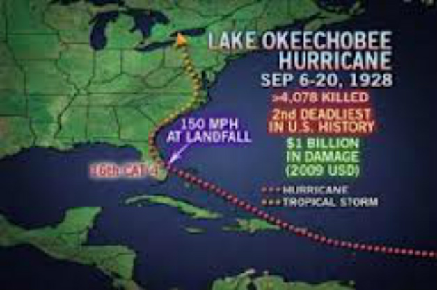
Similar track as Danny so far.
Bad storm. Bigger wetter storm.
Strong High.
La Nina
Can you see how these storms trace the High?
1893 Sea Island Hurricane
Not sure on El Nino or La Nina
Similar but much higher track.
Got strong where the water was warm
Traced the High
Same time of year.
1900 Galveston Hurricane
Similar path but never became a strong Cane early on.
Same time of year.
Strong High
Passed over islands, land much like Georges..kept going
Slammed into Cuba.
Barely Missed Key West
Went Gonzo in the GOM
Galveston Tragedy.
Lastly, extra bonus
1926 Great Miami Hurricane

Similar in some ways.
Steady WNW track ..
Though that may change as forecast for Danny
La Nina - VERY BUSY YEAR
Well, just putting it out there.
BIG, HUGE, WET storm.
Very different finger print than Danny.. so far.
So what about Danny you ask?
Well Danny started out in the Cape Verde Islands.
August but feels more like Early September
Strong El Nino Year.
High has been strong but there are early cold fronts.
Fought SAL the whole way across the Atlantic.
Intensified where he was forecast to weaken.
WNW at 10 MPH
(awaiting 5 PM info)
Small, very small hurricane.
Looks bigger as if he is bulking up for a fight.

What are the steering currents?

Danny is but a marble thrown into the atmosphere.
We will know at 5 PM what the NHC believes.
I've always thought he would go up and over the Islands.
Wasn't sure how but believed that.
Intensity maybe will help him gain latitude.
Usually stronger storms pull North more.
But, he could just as easily go through the islands.
Note the memorable famous ones stay alive.
Can Danny stay alive?
I'll update this blog after the 5 PM.
My point here was to forecast less for Danny ..
A to give a lesson in Hurricane History.
Hope you have learned something.
Remember what you have learned.
The wave behind Danny is forecast to strengthen ...
Note many of these storms formed in El Nino Years.
Others in La Nina Years.
Don't get lost on the El Nino Godzilla Thing..
Take each storm as they come.
Each day as it comes.
Weather changes in real time.
Look at Major Hurricane Danny.
Small storms like Danny can weaken as fast as they strengthened.
And........then bounce back.
Only time will tell.
Remember one thing when you are watching TWC
You are watching history in real time.
Either way he has already made history as a Cat 3
And he made history for being a small hurricane for future research.
Either way he has already made history as a Cat 3
And he made history for being a small hurricane for future research.
Besos BobbiStorm
@bobbistorm on Twitter
Ps posting after the 5 PM
Then offline for the Jewish Sabbath
Be back later tomorrow.
www.spaghettimodels.com
www.hurricanecity.com
www.flhurricane.com
www.crownweather.com
www.nhc.noaa.org
posted by BobbiStorm @ 1:25 PM
![]()


0 Comments:
Post a Comment
<< Home