Rain From What Was Supposed to be Erin in South Florida... Erin is in the Eastern Atlantic!!

Let's start with the rain in South Florida. The rain in South Florida is coming up from the Caribbean from the area that was down in the Caribbean looking yesterday like a developing storm. As I said yesterday morning the WEATHER from Invest 92 would move north rapidly across Cuba into South Florida and the Eastern Gulf of Mexico.
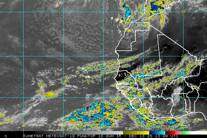
That is evidenced by the larger water vapor loop that shows the flow from the still weak Tropical Disturbance. It's hard to see but the weak center is moving WNW as the weather itself is moving up to the North.

I know it's tropical because when I woke up this morning two different grown kids said to me at different times when the other wasn't around "So, Ma ...what's with all this rain" and then some additional question that sounded like "So, is there anything happening in the Tropics Ma?"
:) Bingo! Tropical Rain on the internal radar of my kids suddenly aware that the rain isn't stopping fast and the umbrella is in the car. That by the way is the reason I rarely carry an umbrella. It's somehow never there when you need it. Note he is now his younger brother's girlfriend's small umbrella to run out to the car to get the other umbrellas that are IN the car as it's raining. I think it's a smurf umbrella. I digress, but it does give y'all a proper picture of what life is like this morning in South Florida from the rain that was formerly known as "About to become Erin" that never got the name. We did get the rain though.
Understand that until a storm forms you have several entities to watch. Until it wraps up nicely it's just rain and low pressure and a whole lot of hype.
Now, for our named tropical storm ERIN is in the distant Atlantic moving generally west. On various model runs it moves a little more north or south of the previous track, but the general direction is WEST.
I'm using this image here as it best shows the strength of the stronger storms and the BANDS that are forming in this slow moving Tropical Storm. It seems to have learned a few things from it's wayward older sister who burned out too fast as she zoomed west at ridiculous speeds.
It also shows the wave over Africa behind it that the GFS develops.
LOCATION...14.5N 25.6W
ABOUT 65 MI...100 KM WSW OF BRAVA IN THE CAPE VERDE ISLANDS
MAXIMUM SUSTAINED WINDS...40 MPH...65 KM/H
PRESENT MOVEMENT...WNW OR 290 DEGREES AT 16 MPH...26 KM/H
MINIMUM CENTRAL PRESSURE...1006 MB...29.71 INCHES
Now let's look at the loop and watch how the Caribbean system disassembled and how Erin came together.

http://www.nhc.noaa.gov/text/refresh/MIATCDAT5+shtml/150845.shtml
Where does it go?
![[Image of 5-day forecast of predicted track, and coastal areas under a warning or a watch]](http://www.nhc.noaa.gov/storm_graphics/AT05/refresh/AL0513W5+gif/113943W_sm.gif)
Model discussion is a bit silly right now as the models will change rapidly and change based upon the storm itself and the real time factors. Last night there was an Intermediate Advisory at 2AM for the Cape Verde Islands. THAT is how FAR AWAY this system is so it's too long to scream Miami or OBX or Bermuda
The Canadian moves it solidly, slowly ...lumbering it's way across the Ocean.

The GFS develops the wave AFTER Erin and that is big news.

That would be the G storm... if the GFS continues this busy trend in the Atlantic.
I'll be back later with more information.

I want to watch Invest 92 a bit more before I give my thoughts. For now rain in South Florida.
Not enough rain by the Invest that is slowly moving WNW & Erin has rain, winds and bands moving WNW.
Besos Bobbi
:)
Ps...Go away...no PS :)
posted by BobbiStorm @ 5:31 AM
![]()


0 Comments:
Post a Comment
<< Home