Monday Night...Chantal Strengthens... Models Pull West Towards FL

http://tropic.ssec.wisc.edu/real-time/mimic-tpw/natl/anim/latest72hrs.gif

7 Day Loop shows Chantal making landfall along the Central Florida East Coast...it shows us Chantal as a Low pressure area... vs a strong Tropical Storm.
http://www.hpc.ncep.noaa.gov/basicwx/day0-7loop.html

The models are beginning to bend to the left (WEST aka FLORIDA) and the 11 PM Track should be interesting.

Note... as I have said over and over if the trough is not that strong the high will build in and things would change. They seem to have changed.......
Note there is a strong disagreement with where Chantal crosses the islands of the Caribbean. Where she crosses them will greatly impact her intensity forecast as well as her timing. Crossing land usually drags down the forward speed as the friction of the land slows the storm as well as any mountains.
Hmmnnnn....

The area from JAX to Melbourne rarely worries on a direct hit.
Then again................the intensity for Chantal at "landfall" has taken a nose dive as many models show her getting lost in the Bahamas. That could change over night with the next model runs as they will have improved data from the recon flight earlier today.
Usually the concept of garbage in ...garbage out applies to models.
Better data in... better modeling package out..
I may update briefly at 11 PM. I think between now and then not much will happen. They may move the cone to the left a bit and the cone will extend further over Florida. Whether they will call for a landfall or not is a curiousity. In truth.. until we get the next model run everything is a shot in the dark.
Until we see how strong the trough is...
Until we see how the high will respond to the weakness..
Until we see what is happening with that vigorous ULL. And, positioning of Chantal in relationship to the ULL is important, because if she moves faster to the west and stays low she could end up closer and to the SE of the ULL and that could intensify her if it doesn't kill her. Positioning is everything with relationship to the effects of a nearby ULL.
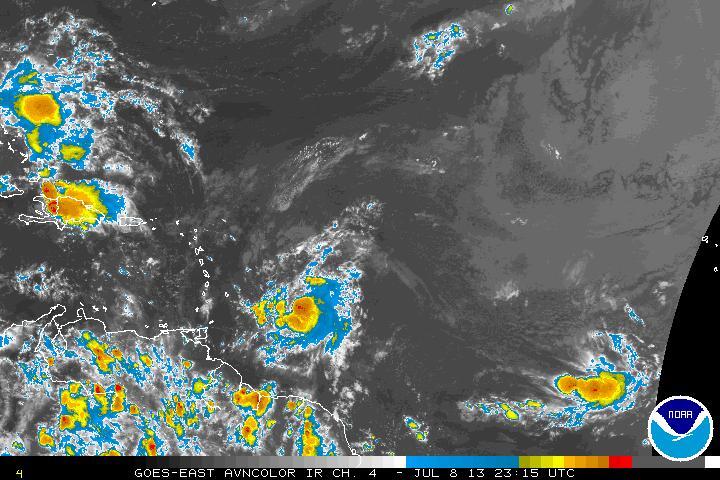
Note the lower end of the ULL has flared up over Haiti ...that is not that far away from Chantal as the crow flies... and there is a system behind Chantal which may become the D storm... Dorian.

Connect the dots.
Sweet Tropical Dreams.
BobbiStorm
Ps... Sit tight and wait for the next model runs.
posted by BobbiStorm @ 6:24 PM
![]()


0 Comments:
Post a Comment
<< Home