UPDATED 8PM 150 MPH! ! NOW - NHC FORECAST 150 MPH AT LANDFALL.. Question NOW is HOW Strong Will it Be? CAT 4 or More!! Watch Out for INLAND Damage Rarely Seen in a GOM Hurricane. More Major Hurricanes in September.
9 PM UPDATE
150 MPH Winds.
As I said below the winds are increasing.
All day the NHC has upped forecast winds at landfall.
Very dangerous storm and the barometer is still dropping.
So winds could get stronger at 11 PM.
High Cat 4 or possibly Cat 5?
Thursday night thoughts while watching #Laura a strong #Category4 close to #cat5 following the NHC track cone towards landfall. This doesn’t mean places further West close to Houston can’t have wind damage. But it’s moving steadily NNW with its 150 MPH winds towards #landfall pic.twitter.com/YCgwz0yQs6— BobbiStorm (@BobbiStorm) August 27, 2020
People have asked me all night about Houston.
I get that as Miami as watched Floyd pass by offshore.
The NHC was sure Miami would not get Floyd.
But it looked so close on the satellite imagery.
So West of the cone and in Houston suburbs...
..you may see damage from wind.
This isn't Harvey, it's not a flooding event.
But you are on the edge of a strong wind field.
Squalls with strong winds swirl in those squalls.
So if you hear things go bump in the night.
It's possible you will have some wind damage.
Hope not...but you have a Cat 4 close by.
So stay INSIDE, hunker down and keep watching.
I'll update at 11 or sooner should it get stronger.
There are some good videos in the blog below.
I blogged live all day - it's a hurricane diary.
Scroll through and see what resonates.
Stay safe and follow the advice of the NHC!
With all my prayers for your safety...
...BobbiStorm

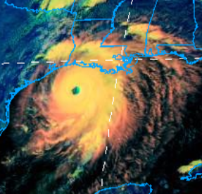
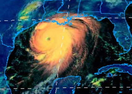
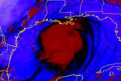
That's the image now.
Below a few hours ago.
So you can see the progression over time.
Again history taught people not to build at the coast.
But to build further inland away from deadly storm surge.
While this part of the #Louisiana check at is used to #hurricanes this intensity is #historic #hurricanelaura #Category4 pic.twitter.com/Nzkli64JgZ— BobbiStorm (@BobbiStorm) August 26, 2020
Normally I blog and tweet about tropical waves with potential for development and wax poetic on waves coming off of Africa or parrallels in history to other possible storms and then I cover the storms. Early on very few of us are posting and later in the game everyone and their brother is online and on air posting about our Deadly Category 4 Hurricane Laura and we ain't sure she has peaked so she coud go Cat FIVE but the NHC will probably stick to their guns and their forecast unless their hands are tied and they are forced to go higher. To be honest, that has happened several times over the last 24 hours so I have low confidence that they won't have to raise the intensity forecast again. She's also moving a bit slower now than she had previously while her large, destructive powerful frame moves inland mile by mile carrying with it deadly storm surge, deadly, destructive winds and oh don't forget the possibility of tornadoes popping out in the bands.
And everyone keeps asking "are we absolutely sure this isn't gonna go to Houston" (that's what she said) and that's a quote from the message I just read from someone who knows hurricanes very well and has good instincts. All I can say is they have a Hurricane Warning currently, though they are forecast to be outside the bulk of the storm and storm surge accompanying Hurricane Laura. Maddening isn't it?
And I wonder always at this point what more I can add that someone else would not post as there is only so many times you can say "hunker down" "get out of town" and "I hope you are prepared" and the obvious "I'my praying for ya" so I'm going to add a bit of information about the places you are hearing about and that will be soon battling the destructive impacts of this hellish hurricane perhaps that will make this more real to you than just computer graphics and names you will hear about throughout the dangerous night.

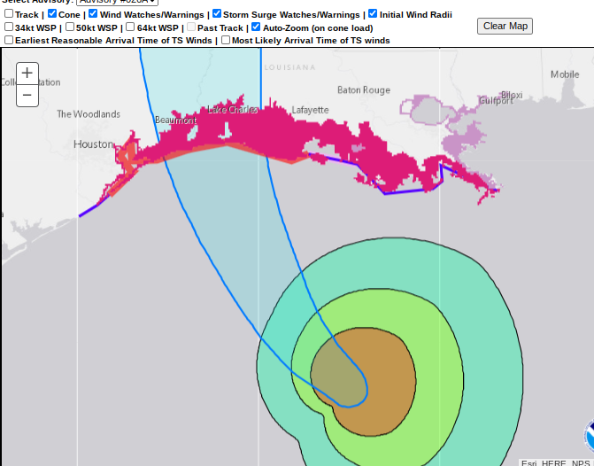
This is the up close view of the watches and warnings.
The various wind fields.
I urge to use this graphic on the NHCsite.
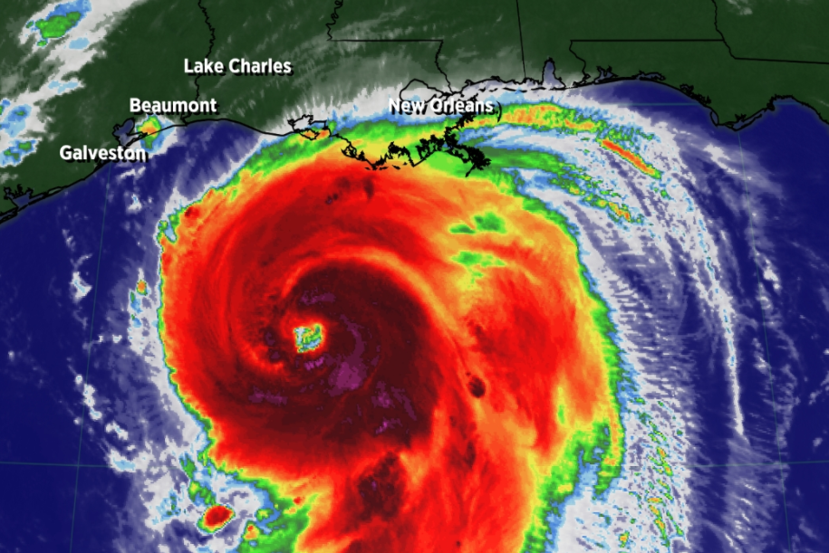
The first thing you see is you can't see the names of the cities.
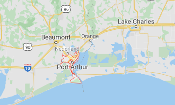
Beaumont to the left and Lake Charles to the right.
That's because they both will be dealing with flooding.
In theory this may be near landfall.
Of course if it doesn't bobble West or East.
If we are absolutely sure...
So here's a video and now you know....
...where Miss Laura is going.
Category 4 Strength currently.
If you scroll back in this Live Blog...
...you'll see they keep uping intensity at landfall.
Now expected to be 150 MPH.
Scenes from Port Arthur below.
I'll add more in real time soon.
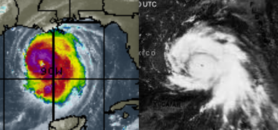
A look into the eye of Laura
Lots of lightning going on.
Intensifying still.
Recon finding higher winds.
This area is rich in oil production.
Remember that.
Beaumont, Lake Charles dealt with Audrey.
Here's an old school news story about that one.
If it goes a bit more to the West..
Beaumont gets it.
More Hurricane History.
Not for the faint of heart.
Makes Stephen King read like a romance com
Last Island ... should be called Lost Island.
Hurricane Laura is much like Hurricane Maria currently.
It ground the island down at landfall.
This is why people must go inland.
Even storm chasers need to find height and protection.
A beautiful place to visit but I wouldn't want to live there.
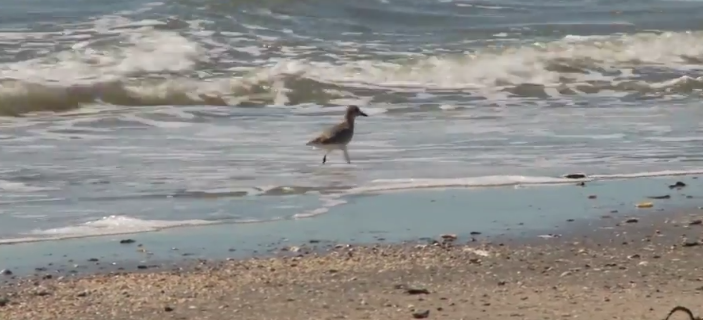
A place sandpipers play.........
...yet they can fly away before a hurricane.
I'll update more later.
Only real question is... does it hit Cat 5?
What intensity is it at upon landfall?
Will the perfect track with model consensus verify?
Stay tuned and please keep reading.
Live blogging at the top.
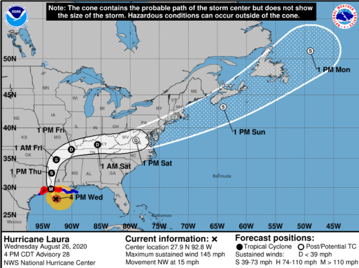
Oh and here's the cone.
The cone has been set in stone for a while.
NHC seems confident.
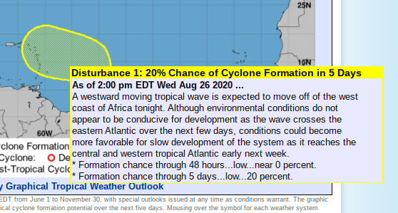
Oh and there's a new area in the Atlantic.
Never say I didn't warn ya.
Low chances currently.
Whoa, numerous lightning flashes in the eye wall, over the last hour. pic.twitter.com/4mYZNy6lst— Dakota Smith (@weatherdak) August 26, 2020
125 MPH Winds.
Rapidly Intensifying.
Close in to Landfall.
Not good news.
But lots of new updates below.
First a video to explain the changes.
Watch the expansion of the Wind field and size of #HurricaneLaura that’s why the NHC changed #hurricanewarnings and went wider pic.twitter.com/0HgITaBFqT— BobbiStorm (@BobbiStorm) August 26, 2020
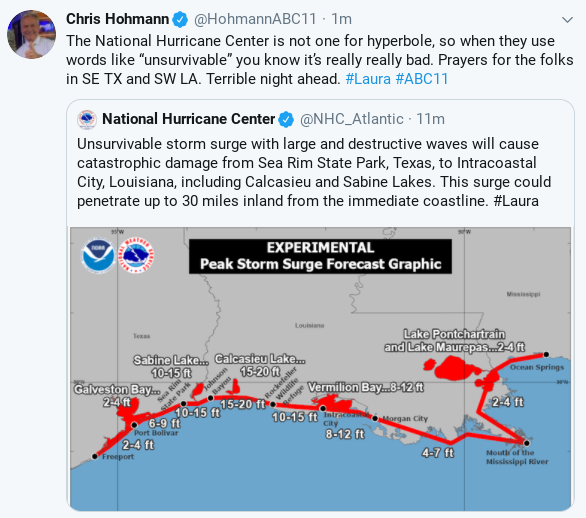
Note the danger zone above.
Also note his words regarding the NHC.
They choose their words carefully
"unsurvivable"
The wording today reminds me of Katrina.
The shape of Laura reminds me of Camille.
I have to keep reminding myself and you...
This is Hurricane Laura, unique in it's way.
Historic and this is history in the making.
Another video to see how this evolved.
#Hurricanewarnings for #HurricaneLaura expanded as wind field expands with rapidly deepening intensity. #Category4 at #landfall. Nearing Cat 5 pic.twitter.com/qqc13hD4cF— BobbiStorm (@BobbiStorm) August 26, 2020
Hurricane Warnings were expanded at 11 AM
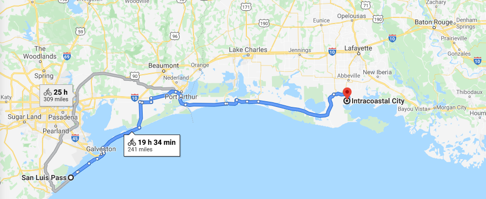
I used a bike measure in honor of 2020.
But look at the coastline.
San Luis Pass to Intracoastal City.
Why did they expand the hurricane warnings?
It doesn't mean the track has changed.
It means the WIND FIELD has changed.
It is expanding, filling in and will impact a wider area.
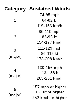
https://www.nhc.noaa.gov/aboutsshws.php link for Saffir-Simpson Scale.
This is a chart from the NHC.
Please refer to their charts and data.
I show this as it's confusing.
People lose sight of where Cat 4 ends...
..and Cat 5 begins.
Cat 5 is 157 MPH
(an odd number I know)
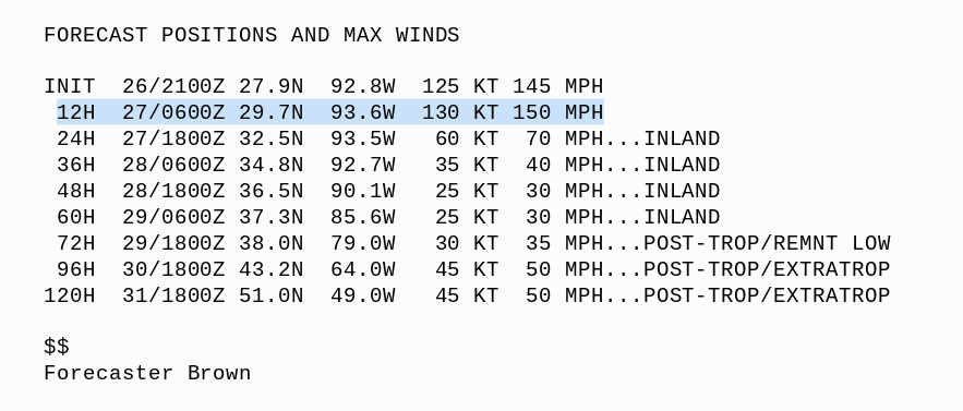
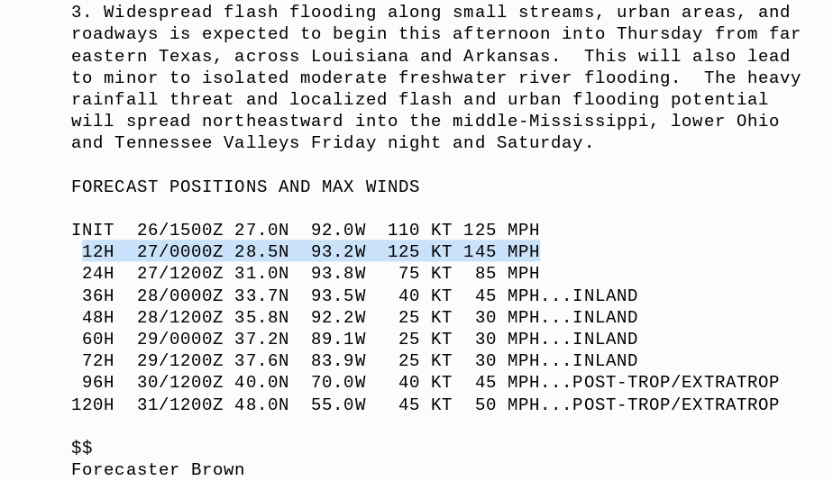
Current forecast to make landfall 145 MPH.
Again the NHC Director always says prepare...
..for 1 category higher.
That would be Cat 5 and that's his rule of thumb.
He said it often yesterday in interviews all day.
Really I do not have much to add to anything I said a few hours ago. The forecast storm surge is forecast to move approximately 40 miles inland. I-10 will most likely be shut down and many local roads, highways will be impassable covered by deadly storm surge that is surging inland with the Major Hurricane WINDS creating WAVES on top of Storm Surge. Check with your local NWS authorities as they cover your area's unique problems when faced with a life and death scenario whereas the NHC issues watches and warnings and tracks the center of the storm with their cone. They have incredibly, informative grahics and information but sadly few click on all those links. If you are near the path of the Laura I urge you to go to their site, click on all the links including and especially Wind Probs as the probs are across such a large area I can't even begin to list them.
My thoughts.
First and foremost follow the advice of the NHC, NWS, your emergency managers and especially your local weather experts. Secondly, the track is a good forecast track as it is based on a tremendous amount of model consensus that all converge over the same spot with a bit of variance a little to the West or to the East but over the border of Texas and Louisiana. What could go wrong or change?
Major Hurricanes that are intensifying, and Laura is, often have bobbles in track and intensity with eye wall replacements. I've mentioned how a slight bobble South spared Downtown Miami direct impacts from a Cat 5 Andrew but slammed a Cat 5 into South Miami Dade County into Homestead. Could that happen? Not going to lie that a bobble cannot be ruled out. I'm also not going to lie and tell you that this couldn't be a Category 5, however it most likely will be a very strong end Category 4. As I say later in this this blog update if you live in the Houston/Galveston Bay area on the left end of the warnings do not let your guard down because sometimes changes happen. Sometimes, but not always, strong Major Hurricanes can "make" their own steering currents and what we mean by that is they carry a strong High Pressure aloft... think of it as an emergency power pack and at times it can reinforce it's current direction and that makes it slower to make a turn and this is forecast to make a turn by all the models as demonstrated by a Cone that almost seems to be set in stone by the NHC. It's 2020 and keep that in mind and storms have intensified on landfall and that trend can contine.
Stay vigilant, careful, hunkered down if you did not get out of town as warned to and keep your phones fully charged with it's backup chargers fully charged. I say this as everyone wants to talk before a storm and check on their relatives in harms way and it's easy to get distracted and not realize your battery is at 21% and I want it at 100% if and when your power goes out. Understand?
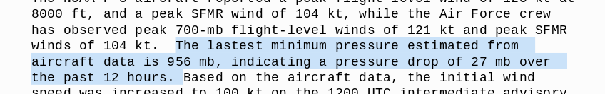
I'll update later most likely with new information regarding Laura's increasing, dangerous intensity, as the pressure drops........the winds respond and go up in intensity. You don't see a pressure drop of 27 MB over 12 hours very often and I do not believe it has stopped intensifying in any way. This is a mean, perfect machine right now vertically perfect and expanding out in all directions as it travels across very warm water close in as it moves towards landfall. Note the comments below from the NHC Discussion that once again I urge you to read.
Forecast to be 145 MPH at landfall.
I can't rule out 10 MPH stronger with the current trend.
Stay tuned, please share and check back later.
I truly wish I had better news to share.
But I do not.
This is as dangerous as it gets.
Remember Laura is already a DEADLY HURRICANE.
And now it's headed towareds landfall.
Be back later,
Please keep reading if you did not do so.
And read my thoughts on the HOUSTON area below.
Written just before the 11 AM advisory was posted.
I cannot emphasize the importance of...
...staying on top of any chances in intensity, track of size.
Imagine this moving inland.
What if it goes further West?
Everyone wants to know especially people in Houston.
The NHC will adjust their cone and warnings.
But this is why I tell you to follow the NWS.
And your local experts.
Hurricanes often have some diversion in direction.
Laura has had a wicked history of ignoring the forecast.
But at some point dynamics kick in...
..and there are steering currents.
But putting this up here at the top.
Raised in Miami you learn to keep watching.
People in Houston know that too!
Prepare even if people make fun of you.
It won't take much to bring down the power grid...
...very far from the track of the eye.
So if you are in the graphics below...
...take it as if you could get it.
Even if you don't.
My advice always.
Sometimes something changes.
We are a Cat 3 now 125 MPH winds.
Stronger than forecast 24 hours ago.
Excellent site with so much data, please use it.
LAURA
Laura in Motion.
#sunrise on #HurricaneLaura probably going #Category4 #writing but words escape me. #Dangerous scenario across a wide area beyond the track of the #eye moving fast inland. Not #harvey not Katrina it’s #Laura a name that will be retired pic.twitter.com/MjSab57qYn— BobbiStorm (@BobbiStorm) August 26, 2020
Laura is not Camille.
But it resembles it and it will be as dangerous.
We have so many more satellite views now.
But this is your classic GOM Major Hurricane.
Long loop of #majorhurricaneLaura coming together into a powerful entity capable of multiple disasters on a wide scope not just the eye. Prayers but actions now will save lives. Expansive destructive. pic.twitter.com/WwukD5gQ0l— BobbiStorm (@BobbiStorm) August 26, 2020
Classic GOM Major Hurricane.
Fills up the small pond.
GOM like a bathtub vs the Pacific.
And Laura is the proverbial bull in the china shop.
But it's a HUGE Bull.
This line from Discussion at 5 AM says everything.
Blake writes good discussion.
Do not just focus on the eye
Quoting from 8 AM Discussion from the NHC that I implore you to read please.
"It should be mentioned Laura is now a large hurricane, and wind, storm surge,
and rainfall hazards will extend far from the center. Do not use the cone graphic
for any representation of these hazards, it is just for the center uncertainty"
That says it all.
Cone below.
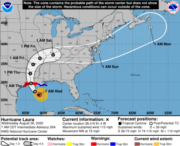
I think the cone is good.
I believe there will be severe impacts to the West.
And horrific hurricane damage to the North of landfall.
But to the East and how far East I'm not sure.
But Lake Charles is under the gun.
If they get the eye or the eye wall.
There's your cone.
Hasn't changed much.
NHC been consistent.
Laura did what expected.
Rapid Intensificaiton.
Bulked up.
Forecast to make that turn.
The discussion says it all and for the NHC to have to remind you of dangers beyond the track of the eye on their cone says it all. When you take that huge ball filled with Tropical Storm force winds,
hurricane winds, strong gusts far from the center, torrential tropical rains and the threat of tornadoes you need to stop focusing on the exact track of the eye unless you a storm chaser trying to figure out where to safely set up. Everyone in the path of Laura is going to get tropical weather impacts and more. Remember Key West when it was far from Laura that was still South of Cuba was hit with a band of gusty weather with gusts in the high 60s toppling trees and serving up damage and panic. And, those cells filled with strong gusts outside the storm move fast and you don't know what hit you until it's gone so remember this is NOT JUST ABOUT LANDFALL. Picking the exact point of landfall is for storm chasers, not those being chased by the Major Hurricane coming at you like a huge wrecking ball filled with dangerous winds bringing deadly results. Run from the water, hide from the wind. Remember that and it's not over until it's totally gone. And this cone goes far inland so please pay attention to that and do not focus on a beach or a bayou down by the coast, this becomes an inland event fast.
https://www.nhc.noaa.gov/text/refresh/
MIATCDAT3+shtml/260858.shtml?
Again rememeber that last line before the
points in the discussion ...... remember the Cone
says "hazardous conditions can occur outside of the cone"
That said this is the cone but check out how far hurricane force and tropical storm force winds extend.
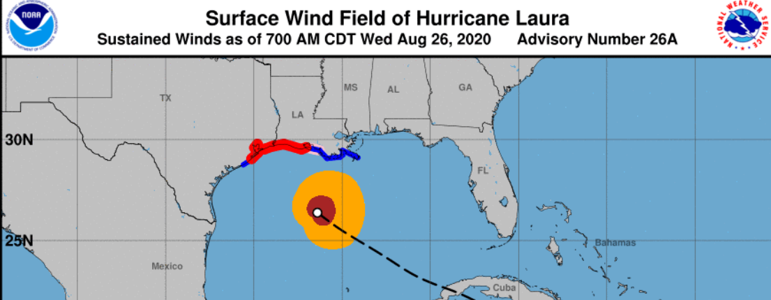
It's going to hit like a wrecking ball.
No other song or phrase comes to mind.
Move that orange ball with tropical storm winds...
...North far inland, across cities, homes, schools.
Infrastructure coming down.
And a very expanse of wooded trees coming down.
Pines, hardwoods snapping in the strong hurricane breeze.
And a hurricane breeze is not a breeze......
...it's like a nuclear blast of terrible weather.
And a hurricane breeze is not a breeze......
...it's like a nuclear blast of terrible weather.
And it can stay strong far inland.......
Lake Charles, Baton Rouge
Alexandria, Shreveport.
Houston will feel strong impacts.
Even Galveston will feel it but hopefully be spared.
Even Galveston will feel it but hopefully be spared.
The Louisiana Coastline mostly East of eye wall..
....will have devastating inland flooding.
From a Storm Surge being shoved fast inland.
My thoughts are if you follow the NHC Cone here and their advice you can't wrong, but to be honest it cannot be over estimated how strong this hurricane is currently and how much stronger it can be at landfall. You can hope for some shear at the last minute to keep it intact, but I'd believe that if it wasn't as strong but as a Major Hurricane going Category 4... it can bust through any inhibiting feature out there. And to be honest this hurricane avoided most of Cuba and Hispnanoila to get into the most perfect position to stay alive and thrive and hurricanes like that are remembered forever usually. Yes and despite that people have died from this storm so it is already a DEADLY storm and it will be even more deadly. In 2020 the death toll should not be as high as it would have been in the 1800s or 1900 but people hold onto false dreams, afraic to move and travel during Covid and prefer denial often to the reality of dealing with death and destruction at dawn and they can avoid that by running from the water and hiding from the wind. And up the way where pines and hardwoods cover the middle part of the state of Louisiana that means staying in s spot where those huge pines will not crash down on your home and slash their way through the bedroom or the living room. It's that simple and I'm being that honest.
Everyone along the coast in the path of the eye & eyewall with its inherent #StormSurge should already have evacuated & be in place. Concerned now on inland high wind damage .. far inland #category4 moving fast #Laura large swath in the crosshairs INLAND pic.twitter.com/a53UjFIU0B— BobbiStorm (@BobbiStorm) August 26, 2020
I'll update later after the 11 AM. Not much to add to what Emergency managers have said and this is not hype, it's an honest assessment of a Category 3 hurricane going Category 4 most likely and I pray it doesn't go Cat 5.
Stay stafe but do what you got to do to stay alive be it from storm surge, inland flooding or trees crashing down taking out your power at the very least. Keep phones fully charged incase you need to make an emergency call and hope that the phone system doesen't go down with the power grid and it's going to take a very long time to put that power grid back into place again. Please share this blog post with anyone in it's path and I don't mean just at the coast but further inland in day 2 and day 3 and day 4. Thank you, there is talk that it could reintensify into a storm in the Atlantic but I believe dealing with the next 3 days is the bigger priority rather than a moving target intantible. Use this link to check your location within that 5 day Cone.
Lots of wooded areas........
..... it may make the damage in Iowa look like nothing.
I wish I had better news.
More later..
BobbiStorm with prayers for all in the path (not just the eye) of Hurricane Laura
@bobbistorm on Twitter and Instagram.
Ps I don't want to add more misery in here but keeping in real, there is another storm likely to develop soon in the distant Atlantic. Models have shown it getting across the Atlantic and so after our Labor Day Weekend event where the Gulf of Mexico will be dealing with search and rescue and know September will bring more hurricanes and probably a strong threat in another part of the country. And we have really only just begun the nasty part of the Hurricane Season so expect more Major Hurricanes along the way.
Add in a song ... like Wrecking Ball but I don't want to minimize this with music but a directive to take this seriously and that means after landfall when the NHC hangs the cone hard right and tropical weather mixed in with other weather similar to but not the same as ISAIAS will carve a path of disaster far from whichever beach or bayout is the point of landfall. This is not your typical hurricane.
posted by BobbiStorm @ 6:52 AM
![]()


0 Comments:
Post a Comment
<< Home