Subtropical Storm Andrea Forms in Atlantic! Tornadoes on Southern Plains... PTS Tornado Watches...
That's official.
Advisory below:
Did you get your tee shirt yet?
I did.... well it's on the way.
Again the forecast track is out to sea....
Waiting on that "strong cold front"
Personally wish it was stronger.
But you can read my thoughts deeper in this post.
You can compare this image with the one below.
Andrea tightened up over the day.
Recon made the call or rather their info did..
And the NHC made their announcement.
SUBTROPICAL STORM ANDREA
Advisories to be issued soon at 6:30 PM
Will update the blog later.
As shown on Earthnull it's definitely closed.
Closed enough....
Recon called that one....
Not the tightest circulation but a circulation just the same.
As for the models....
Well you knew there would be a wrinkle here somewhere.
In general it's expected to be picked up by the cold front.
Remember what I said earlier (below) about the cold front...
Visible loop below shows it has the look.
Sun going down...
Can't wait to see the first visible Monday morning.

***
Keep reading if you have not everything is still time worthy.
Earthnull shows us why we could get Andrea.. possibly.
Not totally sold on this but it's been following the models.
I'll update later today as information from recon comes in.
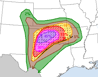
As for the Southern Plains.
That's a lot of warnings.
Purple inside the pink.
That doesn't happen much.
This should be a historic day.
Pray the historic twisters stay away from towns, cities, homes....
I'll update later today.
Please keep reading as everything I said earlier is still relevant.
* *
60% chances for Invest 90L
Will we go red today and get 70% chances later in the day?
Is there a center there anywhere?
Maybe... maybe developing.
It's getting a look.

You can see from the loop above something is happening.
What is happening really isn't exactly clear.
Something tropical maybe....
Maybe a depression?
Maybe recon will fly in today.
They are making that decision in real time.
But the flight plan is on the table.
A front approaches fast from the West...
...to scoop this up and take it out to sea.
Kind of how the Twister scooped Dorothy up...
...and took her to OZ.
Everything is being analyzed carefully.
Bermuda is in the cross hairs for now...
...so that elevates the concern for this odd system.
Forecast to take a hard right turn....
...and go out to sea with the approaching cold front.
Okay it's not really a COLD front.
It's more of a cool down front.
But it's expected to grab it and take it out dancing.
In the Plains there is a HIGH Hot Pink area ...
Rare to see pink on that map.
Many schools in the Oklahoma City area closed today.
Cantore is in town... nuff said.
So prayers for all my friends in that area today.
Prayers are funny.
I pray no one dies...
Tornadoes dance out on the open plains.
Those who love weather get enough to make them smile.
Flooding doesn't happen.
Tornadoes are beautiful out on the open plains.
But there are cities and towns in that grid today.
So this is a developing story today.
Leaving this image here to compare to later.
It's possible we will see depressions status in the Atlantic.
Maybe a few advisories written.
Time will tell.
I will update later today.
Check back later please...
Pay attention to any warnings in your area.
Pray those twisters stay out on open plains.
We are all in awe of Tornadoes.
Huge tornadoes tracking over open land.
Blame it on The Wizard of Oz.
Blame it on Twister.
They intrigue us ....
Different from hurricanes.
Sudden and fast and in your face.
You can track the potential ....
... cyclonic like hurricanes.
But different.
Besos BobbiStorm
@bobbistorm on Twitter and Instagram
Ps... bonus Jimmy Buffet song for a friend
Oh and keep watching the SW Carib....
Convection is beginning to congregate...
Labels: Andrea, flooding, hurricaneseason, Invest90L, maps, music, Storm, subtropical, tornadoes, tropics, weather


0 Comments:
Post a Comment
<< Home