11 PM Tropical Depression Nineteen Forms! Update Lidia Cat 4 in EPAC ... Messy Blobs Moving Fast in GOM....................Tropics Tuesday. Currently Watching Invest 92L and 93L and the Pattern That Will Ultimately Usher in Winter.

Cone below

Will update in the AM with more info.
But 92L is now TD19
****

Models for 93L now only 10%
Yet chances of weather go up.

5 day rain forecast for GOM and FL
Into Atlantic.
.gif)
Lidia became a major hurricane in the EPAC
140 MPH
You can clearly pick out 92L in E ATL
And the fast flow from Lidia W into GOM
From GOM across FL
Which explains the models.

Cat 4 Lidia

Remants, leftovers may get into GOM...
...down the road.
As I said there's NOW problem in GOM
and again down the road.
So that's it.
I guess Lidia is singing this song.
Will you remember it next year?
Keep reading if you haven't done so..
Thanks.
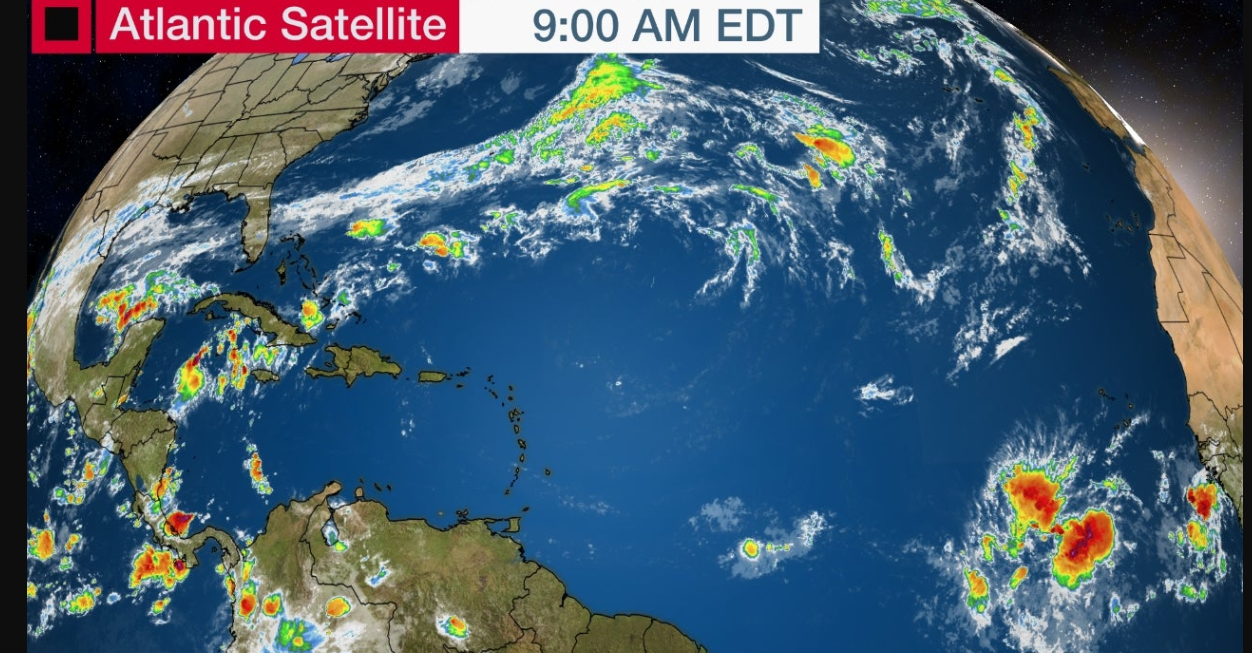
Leading with this awesome, old school satellite imagery. I know as much as I like to watch the Water Vapor Imagery, people prefer colors bright and beautiful. Invest 92L is in the Eastern Atlantic. There's a blob in the BOC which is connected to the Gulf of Mexico. There's a front draped across Florida a sign of Winter to come and a more zonal flow across the tropics. 92L has been at 80% ready to go anytime, but apparently not yet, but it's also at 70% in the next two days so be aware if they find that it's worth upgrading they can at any time.

The yellow X marks the spot.
It's formation zone is from S to N.
North means it gets into the GOM
The red X formation zone curves off towards NW
Been there, done that not talking on it more.
IF it doesn't form as well as models show....
...yeah like Philippe it could get closer to the Islands.
Lots of IFS and the BOC system bears watching.
If and when 93L forms.
The orientation of the flow...
...will show us where it goes.

Note there are two areas of convection and not the flow is strong, more to the North than to the area South of Cuba. Nothins is forming today, and this October feels more like November so while I do worry on my kids and friends in South Florida dealing with an October Surprise it's worth remembering this feels more like a November set up. That said it's also common for systems to form and do one of two things. They grab a front out of the Carib/GOM usually NE or even NNE depending on the orientation of the front and then it's gone up into the Atlantic. Or.... one starts to catch a front, steering currents go weak and it travels oddly around in awkward movement until another front comes for it to catch towards the North or NE or even ENE.
.gif)
Looking at Earthnull....

Remember EPAC is busy.
Usually, GOM slow when EPAC busy.
So this it's slow motion development for now.
So keep watching.
If you have fall color enjoy it.
If you have balmy breezes enjoy it.
BobbiStorm
@bobbistorm on Twitter and Instagram
Ps Remember there's a seasonal ballet that takes place as tropical systems try to move towards the Poles and that pushes colder weather down towards the South. It's how the atmosphere of our planet it designed and thankfully the flow keeps moving the air around. So know for every tropical system that pushes up towards the N ATL it's one step closer to Winter descending down.
Thanks for reading. I will admit it's hard to write about weather today in a clear, concise way as my phone is constantly going off from my kids and friends sending me news about loved ones dead or in danger in Israel or being held hostage with images of their face put out by Hamas. I have a lot of kids, they have a lot of friends and many have lived at my house at one time or another when they were younger before they or their family moved to Israel.
posted by BobbiStorm @ 7:15 AM
![]()


0 Comments:
Post a Comment
<< Home