Beautiful CV Wave... Awesome Shape. Models Like it. Anniversary of Great Miami Hurricane 1926. Hugo 1989

Okay, to be honest, this is not the most conducive set up for tropical development.
You have an Upper Level Low swirling around in the Caribbean linked up with a feature that deserves a name as it has spent more time off the cost of South Florida that many drug smugglers or lobster fisherman. It's as if that area is searching for gold coins lost at sea in a hurricane that hit the Bahamas. It's parked. It's not moving. It oozes to the left...to the right but it is anchored with a long rope and not leaving. Been watching it for the last month now. It's the only feature really spinning consistently in the tropics. Annoying.
The combined spinning of the two ULLs make it hard to get anything going south of Florida. That's probably good for South Florida as anything that would get going would grab a cold front north and slam right into said Florida.
Note the cold front pressing down into the Florida Panhandle the 3rd week of September. Seems Mother Nature has her own agenda this year. September is for Hurricanes Darlin... not cold fronts that make it past Tallahassee. For real?
I tried to make the AC warmer in Raleigh, but the AC wasn't on.. I turned it off and opened the window. Sort of chilly out there too... Though round these parts cold fronts in September last about as long as cold fronts in Miami do in November. A day or so later it's warm again. Hey it might be warm by 4 PM...

I'm kind of thrilled when the wind actually blows some here so I'll take it. I miss my Miami breezes.
Let's look at Tallahassee since I brought it up for a good reason.
That's a wide spread this week. 93 as a high early in the week ending with a 64 for a low later in the week. Obviously there is another front after this moderating one.

There's a pattern and this is not the first front to blast it's way through or... to slowly crawl through a stationary phase before being shoved along by the next front that was stronger. Sort of like waves.. one is weak but wet, one is larger but dry.... finally one is just right.
The next wave that has model support (that means the NHC is watching it) is just emerging off the coast of Africa.

Let's take a look at it on satellite imagery.
O... for "Orgasmically delicious!!" O for "OH MY GOSH WHAT A BEAUTIFUL WAVE!!"

Cannot argue with that wave there... WOW....OH WOW....
But...why would it develop when the others before it didn't?
We are staying cautious with a yellow 10% chance for now.. keep watching.
Hurricane Hugo when it was just a wave coming off of Africa below.

This is the time for a Cape Verde Wave to develop.. .if not now when?
It has a beautiful shape...meaning it most likely has a low attached.
It's got the best shape I've seen since...Hugo or Donna or maybe I'm being silly..
because it's been a long time since I've seen a wave come off Africa that looks like this..
and... Cousin Sal is not as strong a factor as he was...
Something to think on ....
Besos Bobbi
Ps..Anyone who knows me knows I'm an expert in Miami History and Miami Hurricanes; tropical hurricanes that is though I do know some UM football. September 17th is so connected in my mind to the largest, strongest, hurricane Miami has ever dealt with head on.. in 1926
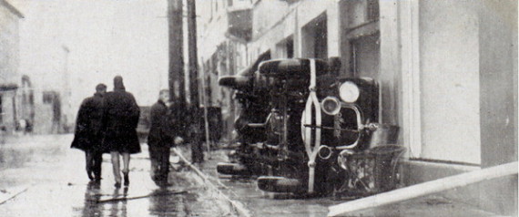
Model T Fords strewed across the sidewalks
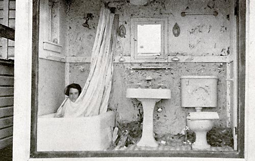
Women hiding in bathtubs to ride out the storm vs bathtub gin.
A young city just turning 30 years old flattened. Down but never out ... Miami always comes back from adversity.

Biscayne Boulevard as always having a building boom... halted for clean up before the buildings were finished. A few were scaled back a bit ...but they were finished.

And, for those of you who know Haulover, Surfside... a bridge to no where...
I'll blog more on this historic storm that defined a city.
A city that rather than gave up named their football team at the new colleget that was just opening after the Hurricanes.

I'll write more about this later today and tomorrow.
Stay tuned and keep watching that incredibly beautiful wave that is so far away and may never make the crossing ...or it might make it across. Time will tell but Sal is out somewhere sipping cafecito and gobbling up guava pastelitos!
Note...in 1927 Miami made up postcards to sell the story of the Hurricane... and rebuilding better than before...
posted by BobbiStorm @ 6:51 AM
![]()


0 Comments:
Post a Comment
<< Home