Tropical Depression Karen FL Bound... Problem with Models

Wow, who saw THAT coming?

There's a problem with the models this season in odd ways that are hard to explain. And, this is important because every thing is model driven these days.
The GFS took the storm to the NE as a stronger storm up the Appalachians.
The EURO took the storm to the left and kept it weaker.
No model showed this happening several days ago. Models are supposed to show the long term, the 5 day and 7 and even indicate the path 10 days out. On Friday models did get a bit funky and a few showed the storm dipping down in the Gulf or going more to the East and the dropping down but they were discounted as Falderal and Fiddle-Dee-Dee. Inconsequential models, but models we watch none the less.
Go back and see what I wrote on Friday when I mentioned it or just look at the links I posted..
http://hurricaneharbor.blogspot.com/2013/10/changes-in-tropical-storm-karen.html
Take the easy route and avoid the Carpenters Song..
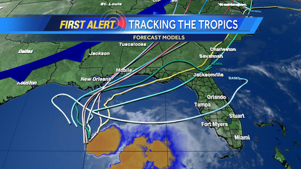
FRIDAY... GFS Ensemble...

The "ensemble" shows it making a sharp right turn and then zooming NE with the Cold Front. A few of the ensemble members... did show the storm going across North Florida and exiting into the Ocean about Jacksonville Beach. The CONE stuck with the earlier scenario bringing it in a bit further to the South. Remember.. I said the furthest north they saw the storm going was Morehead City, NC.
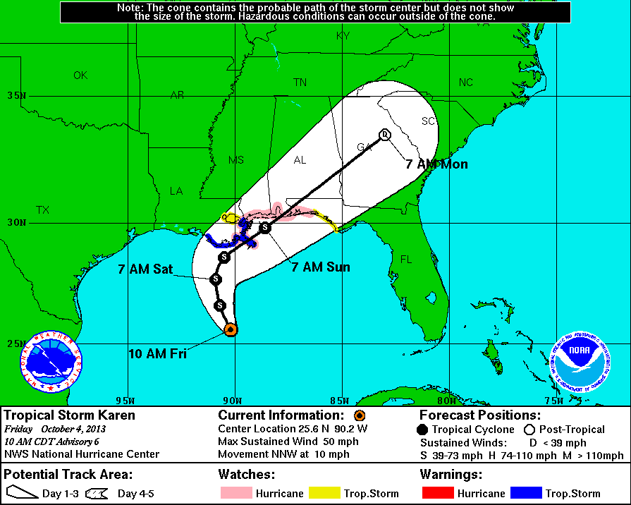
There was no talk that 24 hours later the storm would stall, fall apart and the cone would show Florida as the main target of whatever is left of Karen.
Note tonight's models more closely mirror the tracks from the GFS ensemble that everyone wrote off on Friday.. Hmmnnn. Seems the outlying models on Friday WERE RIGHT. But, due to a need to go with consistency and CLIMO and being able to maintain a forecast that can be verified they were not taken seriously. But, they were right...

Now Florida is the main target in the Wind Probs. An out lying chance that this reforms in the Atlantic and heads to Nova Scotia ...just so you know.
JACKSONVILLE   34  X   X( X)   X( X)   3( 3)   X( 3)   X( 3)   X( 3)

DAYTONA BEACH  34  X   X( X)   X( X)   3( 3)   X( 3)   X( 3)   X( 3)

ORLANDO FL     34  X   X( X)   X( X)   3( 3)   X( 3)   X( 3)   X( 3)

TAMPA FL       34  X   X( X)   1( 1)   3( 4)   X( 4)   X( 4)   X( 4)

CEDAR KEY FL   34  X   X( X)   1( 1)   7( 8)   X( 8)   X( 8)   X( 8)

TALLAHASSEE FL 34  X   X( X)   2( 2)   6( 8)   X( 8)   X( 8)   X( 8)

ST MARKS FL    34  X   X( X)   2( 2)   7( 9)   X( 9)   X( 9)   X( 9)

APALACHICOLA   34  X   X( X)   6( 6)   8(14)   X(14)   X(14)   X(14)

GFMX 290N 850W 34  X   X( X)   8( 8)   8(16)   X(16)   X(16)   X(16)

PANAMA CITY FL 34  X   X( X)   8( 8)   5(13)   X(13)   X(13)   X(13)

PENSACOLA FL   34  X   1( 1)   4( 5)   1( 6)   X( 6)   X( 6)   X( 6)
I love the NHC..the job they do..the discussion they right and the packages they prepare. Some of the nicest, smartest and wisest people I know work there. But, there is such a pressure to have model support for every forecast package and that means the package is only as good as the model support.
It's an odd year. I know. Happens.
But, think on how many storms were developed far out by the GFS and EURO when they were but weak waves coming off of Africa and none of those storms developed. Models have a bias for storms that work well with CLIMO as the CLIMO is part of the programs that make up the modeling package.
So... this should have been seen as a possibility on Thursday and Friday and even on Wednesday. And, I will give them a lot of credit for constantly mentioning they had low confidence in their forecast in the Discusison which most people don't read except people like me. The AVERAGE person sees the "CONE" on their Phone... their APP or whatever they use to show them a quick visual of the Cliff Notes version of the NHC forecast package.
Note my questions in red.
1000 PM CDT SAT OCT 05 2013

KAREN HAS ESSENTIALLY REMAINED STATIONARY FOR THE LAST SEVERAL HOURS
AND THAT LACK OF MOTION...COUPLED WITH INCREASING UPPER-LEVEL WINDS
AHEAD OF AN EASTWARD-MOVING DEEP-LAYER TROUGH
so much for the area of lighter winds and intensification..
...HAS INCREASED THE SHEAR SIGNIFICANTLY ACROSS THE CYCLONE. THE RESULT IS
THAT CONVECTION HAS WEAKENED AND BECOME DISPLACED WELL TO THE EAST AND
SOUTHEAST OF THE LOW-LEVEL CIRCULATION CENTER. SATELLITE
note the convection was always displaced & the word SE..
CLASSIFICATIONS FROM TAFB SUPPORTED KEEPING KAREN AS A BORDERLINE
TROPICAL STORM AT 00Z...BUT THE LACK OF CONVECTION NEAR THE CENTER
SINCE THEN REQUIRES A DOWNGRADE TO DEPRESSION STATUS AT THE 03Z
ADVISORY TIME. GIVEN THAT THE VERTICAL WIND SHEAR IS FORECAST TO
GET EVEN STRONGER OVER THE NEXT 2 DAYS...RE-STRENGTHENING BACK TO
TROPICAL STORM STATUS IS NOT LIKELY...ESPECIALLY SINCE THE
MID-LEVELS OF THE TROPOSPHERE WILL BECOME INCREASINGLY DRIER AS
WELL...PREVENTING THE RE-DEVELOPMENT OF DEEP CONVECTION OVER THE
CENTER. AS A RESULT...TROPICAL STORM WARNINGS HAVE BEEN
DISCONTINUED.
THE STATIONARY MOTION OF KAREN THE PAST 6-9 HOURS HAS BEEN DUE TO A
NORTHWEST-TO-SOUTHEAST ORIENTED MID-/UPPER-LEVEL RIDGE LOCATED
ACROSS FLORIDA AND THE SOUTHEASTERN UNITED STATES...WHICH HAS
this was never mentioned in earlier discussion.."blocking pattern"
BLOCKED ANY EASTWARD MOTION BY THE CYCLONE. THIS BLOCKING PATTERN
IS EXPECTED TO SHIFT SLOWLY EASTWARD OVER THE NEXT TWO DAYS...
so basically the low level center is following the convectionthat has always been to the right of the center...as opposed to the convection wrapping around the centerALLOWING KAREN OR ITS REMNANTS TO MOVE IN A EASTWARD TO EAST-NORTHEASTWARD DIRECTION UNTIL THE CYCLONE DISSIPATES IN 48-72 HOURS OR IS ABSORBED BY AN APPROACHING FRONTAL SYSTEM. THE NHC FORECAST TRACK IS SIMILAR TO THE PREVIOUS ADVISORY AND THE CONSENSUS MODEL TVCA...AND SHOWS KAREN PASSING NEAR OR OVER THE EXTREME SOUTHEASTERN TIP OF LOUISIANA IN ABOUT 24 HOURS...AND REMAINING JUST OFFSHORE OF THE NORTHERN GULF COAST AFTER THAT.
so just talks about the tip of LA being clipped but nothing about Ocala being in the cone..
Now.. my problem is this...
IF the storm is weak and just barely a depression..nothing more than a Tropical Disturbance then it's possible that the Cold Front will NEVER pick it up. It's shallow and doing the opposite of a weak African Wave that doesn't develop and doesn't catch the pull to the North and keeps going West but in this case Karen is going East. Same concept, just a different direction.
So, does Karen die out or do her remnants get new strength and reform or even more possibly does the center down the road reform under the stronger convection that remains or do we just stop tracking the tropics and go with Winter Storms? Well, forget that last part... the season is far from over if you believe some of the new models about possible development in the Atlantic soon.

Check out that BAMS... Model watching is better than playing online games or maybe it is online games?
Jacksonville pay attention!
So my question for tonight is... why in Twister when they drive through the house in Oklahoma in the truck is their a Miami Dolphins poster on the wall in the kid's bedroom? It's Oklahoma where the wind comes sweeping down the planes and it should be a Crimson and Cream poster of the Sooners Football team.
Just saying... things like that annoy me. Yeah, watching Twister on TV while typing this. So, so love that movie. Love the actor that plays Rusty who is also in Leap of Faith with Steve Martin. Guess he's a local actor..
My question concerning Karen is two fold.
1. Can a new center develop under the convection and will it matter if the conditions in the GOM are so negative? I ask that because this is the year of storms coming back to life...
2. Does the front miss Karen completely and leave her wandering around the GOM or the Atlantic off the coast of Jax and Savannah??
Note the 5 Day Cone has been all over the place so they are questions worth asking.
Hmnnnn
And... out in the Atlantic it's worth noting there IS moisture out there and convection and it's catching my attention.
Long range models are playing with development.

Maybe the models are crazy. Possible.
Note in the Caribbean the water is warm and another system like this could develop. Especially when you consider the fact that West bound waves are still ...well.... moving West into the Carib.

Look at a map of Global Tropic Hazards for this coming week..

Red and white candy canes in the Caribbean..................
Check out those lower end ensemble members from the GFS... Hello Pt. St. Lucie and Miami.. Bahamas...oh I want to take ya.. or maybe it just sits out there looping around?
And, lastly.... check out the Juice Loop... the spin is gone with Karen.. but the dark orange-red moisture keeps moving into the Caribbean.
Lastly.......I will not go on a rant about how this storm was so over hyped by the media, but more so the over reacting by some local authorities. This was NEVER supposed to more than a low end Category 1 Hurricane "maybe" and yet State of Emergencies were put into effect and evacuations for areas that really do not need to be evacuated from when most models showed a landfall as a Tropical Storm and not a wet one at that as the real moisture was always... let me say this again ALWAYS supposed to the to the far right of the storm. Nuff Said.
I'll be back later with more information and keeping up with Karen and football and oh and the forecast for NC tomorrow is 86 degrees... warm temperatures for October. Heck.. we didn't have weather like this in September. Something to think on..
Watch the loops. Seems like the moisture is being pushed ESE and even a bit to the SE more than being picked up by the front. But, you just never know... that's what's interesting about tropical weather. And, again she is a very weak, shallow system.. moving Eastish...

Sweet Tropical Dreams,
Bobbi
http://www.youtube.com/watch?v=0htxcFhNFyo
Cinderella should be wearing these beads if you ask me... or maybe she is...

posted by BobbiStorm @ 10:46 PM
![]()


0 Comments:
Post a Comment
<< Home