Trying to Understand Tropical Storm Karen...

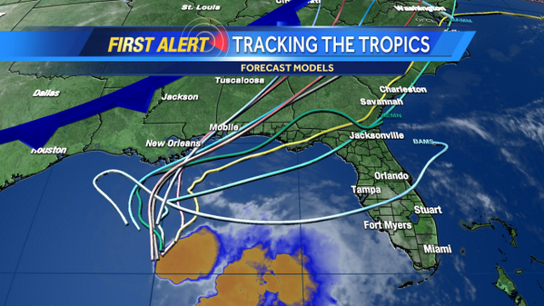
This loop above best shows the problems with Tropical Storm Karen.
To start with she really doesn't have a problem she is just the way she is... she isn't Camille, she isn't Opal, she is Karen.
You can see her well defined circulation to the left of the bright red mass of convection.
The CENTER is moving NNW at 10 MPH packing 60 MPH winds moving towards a landfall somewhere between Grand Isle to Destin as the forecasters have a wide cone seemingly unable to be sure on the models. I still go with a land fall near Mobile Bay with the majority of weather moving towards the Panhandle of Florida. As a matter of fact depending on the strength of the shear the bright red "weather mass" could move over the entire State of Florida increasing instability and causing more flooding rains on which ever area gets his with the strongest part of this mess.
Again there are two centers to watch here and a third factor being the Storm Surge.
She has very low wind speeds in the world of Tropical Storms. She could be reaching an area where the shear relaxes and just prior to land fall "Opal Like" intensify ...however she would be intensifying maybe to 70 or 75mph not Cat 2 or Cat 3. Just a weak tropical storm...there is no reason here to panic on the winds.
The "weather mass" to the right containing the strongest convection and the highest possibilities for Twisters or severe flooding is not a very consistent mass and can ooze and change and rearrange itself at the drop of a hat or the barometric pressure. So...if you live ANYWHERE to the RIGHT of the CENTER of Karen... please pay attention to local breaking weather news. Any where meaning on a the face of a clock if you are at 12:30 or 1:30 or 3:30 ... pay attention and keep an eye on Karen. Don't think "Oh I live in Indian Pass Florida and they said she is pulling to the left and going to make landfall near LA or MS... her CENTER will make landfall there with her 50 or 60 or 45 or 70 MPH winds. The weather may be coming directly at you far from her center.
Storm surge is another issue. Several years back a weak storm that traversed the length of the Gulf of Mexico and came up from the Carib made landfall near P-Cola and we are in Apalachicola Bay had massive flooding far from land fall partially because of the direction of the storm and the piling up of the water in that area at the NW edge of the Gulf of Mexico.
Read through this site below which explains more about how flooding and the slope of the land under the water near the beach affects flooding.
http://www.flghc.org/docs/2013WS/WS-131-2.pdf

Where EXACTLY does she go? Well if the NHC isn't 100% sure yet... why would I say that I really think this storm will make land fall near Mobile Bay or a little to the left or right. She might also clip Grand Isle as she makes her final turn to the right to catch the cold hearted trough.
The NHC has used the LOW CONFIDENCE term in their discussion and I agree more or less. They are looking at the models and weighing them back and forth vs doing it Old School. Sometimes the models agree and other times they don't and they won't put out a forecast without verifying it with model agreement.
.WITH
THE BIG QUESTION BEING THE TIMING OF THE NORTHEASTWARD TURN.  THE
UKMET...NAVGEM...AND CANADIAN MODELS DELAY THE TURN UNTIL AFTER
KAREN MAKES LANDFALL IN SOUTHERN LOUISIANA.  THE GFS SHOWS THE
SHARPEST TURN...AND IT CALLS FOR THE CENTER TO MAKE LANDFALL ON THE
NORTHWESTERN FLORIDA PENINSULA.  THE GFDL...HWRF...AND ECMWF ARE
BETWEEN THESE EXTREMES WITH LANDFALL FORECASTS FROM THE MOUTH OF
THE MISSISSIPPI RIVER TO THE WESTERN FLORIDA PANHANDLE.  OVERALL...
THE GUIDANCE IS SLOWER THAN IT WAS 6 HOURS AGO...AND THE GUIDANCE
ENVELOPE HAS SHIFTED A LITTLE TO THE WEST DURING THE FIRST 48
HOURS.  THE NEW FORECAST TRACK REFLECTS THESE TRENDS WITH A SLIGHT
WESTWARD SHIFT AND A SLOWER FORWARD SPEED.  GIVEN THE SPREAD OF
THE GUIDANCE...THE FORECAST OF THE LANDFALL POSITION IS LOW
CONFIDENCE.
The ULL in the Atlantic is strengthening and the trough doesn't look like it is digging that fast and yet Karen is climbing steadily in latitude making progress on her trek towards what could be multiple land falls. LA and then a curve over to MS or AL near FL.

Also they mention timing. To my eye the timing on this has been off the whole time.
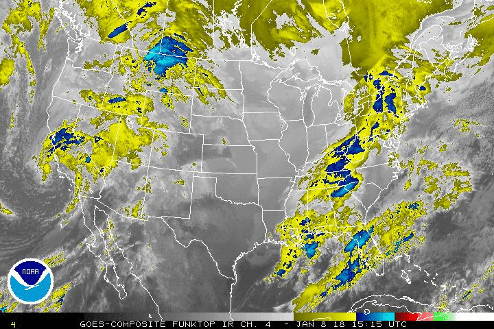
Local weather people in Carolina are already talking on how weak this front is compared to the ones last month and how the temperatures won't go down very much. You can see the trough better here below:

She did seem to slow down, though I don't think that much but their discussion implies otherwise.
They really don't seem sure.
Another problem with storms like this is the develop or fall apart or change direction or stall out so far in real time close to shore creating a problem for long range forecasting. It is easier to forecast Category 3 Cape Verde Hurricanes traveling WNW towards land that it is to forecast a small little Tropical Storm close in to the beaches of the GOM.
THE INTENSITY FORECAST IS RATHER PROBLEMATIC.  FIRST...KAREN IS
LIKELY TO INTERACT WITH A SMALL UPPER-LEVEL TROUGH DURING THE NEXT
24 HOURS...WHICH MIGHT PROVIDE SOME SUPPORT FOR RENEWED CONVECTION.
SECOND...THE SHEAR MAY DIMINISH IN THE WAKE OF THE TROUGH...WHICH
COULD ALLOW FOR INTENSIFICATION...ESPECIALLY IF KAREN TURNS
NORTHEASTWARD WHILE STILL OVER WATER.  THE ECMWF SHOWS ABOUT 10 MB
OF DEEPENING AFTER RECURVATURE...AND THE GFS...HWRF...AND GFDL
MODELS SHOW MORE.  BASED ON THESE MODELS AND CURRENT TRENDS...THE
INTENSITY FORECAST IS MODIFIED TO SHOW LITTLE CHANGE IN STRENGTH
THROUGH 24 HOURS...FOLLOWED BY INTENSIFICATION TO NEAR HURRICANE
STRENGTH BY 48 HOURS.  AFTER LANDFALL...KAREN SHOULD WEAKEN AND
EVENTUALLY BECOME EXTRATROPICAL AS IT MERGES WITH THE DEEP-LAYER
TROUGH.

SINCE THE CURRENT FORECAST IS SLOWER THAN THE PREVIOUS FORECAST...NO
CHANGE IN WATCHES AND WARNINGS IS NECESSARY AT THIS TIME.  THIS
WILL BE REVISITED AS KAREN PROGRESSES NORTHWARD ACROSS THE CENTRAL
GULF OF MEXICO.
![[Image of 3-day forecast and coastal areas under a warning or a watch]](http://www.nhc.noaa.gov/storm_graphics/AT12/refresh/AL1213W_NL+gif/090446W_NL_sm.gif)
Again this is for land fall of the CENTER..NOT for the "Weather Mass" she is carring with her that is pulling to the right like an ADD child in a grocery store after having too much sugar and trying to grab the Fruity Pebbles fast while Momma tries to talk on the phone, find her coupons and remember which cereal was healthier for little Jr who is knocking over the cereal faster than she could say "Whoa Bubba come back here"
I think that pretty much sums up the problems figuring out Karen with models so squeamish so close to land fall.
The bigger change in the forecast is the long term. She is now forecast to exit into the Atlantic after traveling NE through the SE as a Remnant Low. The furthest north they have wind probs for is Montauk Point, NY.
http://www.nhc.noaa.gov/text/refresh/MIAPWSAT2+shtml/040851.shtml?
Jim Cantore looks a bit frustrated on TV...
Newest models have come in looking more confusing. Note that the Discussion from the NHC and the forecast package is running late.. probably trying to figure out what to say and which model is most reliable while trying to correlate that with the storm itself.

HMNNNN Look at that model that dips down..curves back. Hey it's the BAMS.. bright raspberry red.. guess it had too many Fruit Loops.
People in Orlando sat up and took notice FAST to that model change...
https://twitter.com/ericburris/status/386130350176350208/photo/1
Great discussion from the NWS out of Tallahassee...they do such a great job. Note their concerns on beach erosion from the storm surge and weather associated with Karen.
Near and Short Term [Today Through Sunday]...
All eyes will continue to be focused to the south, where Tropical
Storm Karen continues to slowly develop as it churns off to the N-NW
at 10 around mph over the central Gulf of Mexico. As of 200 AM EDT,
Karen was located at latitude 24.5 degrees N and longitude 89.5
degrees W, or about 320 miles to the south of the Mississippi River
entrance. Karen is currently expected gradually decrease in forward
speed as well as slowly turn towards the N, then eventually to the
NE, as it nears landfall near the AL/FL border by late Saturday
Night and Sunday Morning. This is the official forecast from the
National Hurricane Center, and track wise, is closest to the GFDL
and HWRF. Based on this fcst, expect gradually deteriorating
conditions to spread northward into the FL Panhandle Coastal waters
by Saturday afternoon, with gradually increasing PoPs, QPF, and wind
over the western interior of the CWA on Saturday night and Sunday.
This rainfall could become heavy at times on Sunday, with the
potential for inland flooding over the western third of the region
before the system exits the area to the NE. It is still a bit early
to project final rainfall amounts, but widespread 3 to 5 inch totals
(with locally higher amounts) certainly appear possible for much of
SE AL and the western FL Panhandle which could certainly cause both
Flash and Riverine Flooding. While lower rainfall amounts are
currently expected further to the east, this could certainly change
over time as once again a large nocturnal convective burst has
formed well to the east of Karen`s center of circulation, and while
this would likely limit any further intensification, our high QPF
fcst may need to be shifted to the east. Also, while the current
Storm Surge is not expected to be particularly high, battering surf
is expected to begin affecting the Walton and Bay county Coastlines
over the weekend, with life-threatening rip currents and at least
minor beach erosion expected.
BobbiStorm's Bottom Line:
Don't be ignorant or naive where storms like this are concerned... watch the weather not just the winds.
If the weather is being blown off in your direction, pay attention.
Pay attention to any changes in her intensity as many models show her intensifying before land fall as shear relaxes.
Pay attention to any changes in the models and as always watch the storm...
Besos Bobbi
posted by BobbiStorm @ 7:26 AM
![]()


0 Comments:
Post a Comment
<< Home