Miami Flooding & the Problem with Gulf Systems & Tropical Storm Karen 65 MPH

The tracks going back Freedom Tower on the way to the Port of Miami are UNDERWATER in this picture. An hour later the water was gone... Crazy.

Just another day of living in the Tropics in Miami :) and it is a beautiful place to live.

As for Tropical Storm Karen....
She is suffering from shear that is blowing off her moisture to the "right" of her center.. meaning East, NE and some of the rain and instability in the atmosphere in Miami currently is from that rain that has been blown so far away... from Karen. Shear is the bad guy here as well as a delicate circulation center.
See the Discussion below from the NHC and note my comments.
TROPICAL STORM KAREN DISCUSSION NUMBER   2
NWS NATIONAL HURRICANE CENTER MIAMI FL       AL122013
1000 AM CDT THU OCT 03 2013

KAREN CONTINUES TO HAVE A SOMEWHAT SHEARED APPEARANCE ON SATELLITE
IMAGERY...WITH THE DEEP CONVECTION DISPLACED TO THE NORTHEAST OF THE
LOW-LEVEL CENTER. THIS IS CONSISTENT WITH THE 20 OR SO KT OF SHEAR
ANALYZED OVER THE CYCLONE BY THE SHIPS MODEL. THE INITIAL INTENSITY
IS RAISED TO 55 KT BASED ON SEVERAL BIAS-CORRECTED SFMR WINDS IN
THE 50-55 KT RANGE REPORTED BY THE AIRCRAFT. WITH MODERATE SHEAR
EXPECTED TO CONTINUE...ONLY GRADUAL STRENGTHENING IS EXPECTED
BEFORE THE SHEAR INCREASES FURTHER IN ABOUT 48 HOURS. SOME
WEAKENING IS ANTICIPATED AS KAREN APPROACHES THE GULF COAST...BUT
THE STORM COULD STILL BE NEAR HURRICANE STRENGTH AT LANDFALL. THE
NHC FORECAST IS CLOSE TO THE SHIPS AND LGEM MODELS THROUGH THE
PERIOD. KAREN SHOULD BE INVOLVED WITH A FRONTAL ZONE BY DAY 4 AND
ABSORBED BY THE FRONT BY DAY 5.
Basically means.... she is dealing with shear.. They are unsure if this will continue
or not and they are still watching the storm and the synoptics and the models.. unsure.Oh and not sure where their "should" in the hedging on the arrival and timing of thecold front.THE INITIAL MOTION ESTIMATE IS STILL A RELATIVELY UNCERTAIN 330/10.
THE TRACK FORECAST REASONINS HAS NOT CHANGED...AS KAREN WILL MOVE
AROUND THE PERIPHERY OF THE SUBTROPICAL RIDGE DURING THE NEXT DAY
OR SO AND THEN ACCELERATE NORTHEASTWARD AHEAD OF A MID/UPPER-LEVEL
TROUGH. THERE REMAINS CONSIDERABLE EAST/WEST SPREAD IN THE TRACK
GUIDANCE...WITH THE GFS REMAINING WELL EAST OF THE OTHER GLOBAL
MODELS AND ITS ENSEMBLE MEAN. THE TRACK GUIDANCE HAS SHIFTED A
LITTLE TO THE WEST THIS CYCLE...AND THE NEW NHC TRACK IS CLOSE TO
THE MULTI-MODEL CONSENSUS AND ABOUT A HALF A DEGREE LEFT OF THE
PREVIOUS TRACK THROUGH 48 HOURS. NOTE THAT A STRONGER STORM WOULD
LIKELY MOVER FARTHER EAST...WHILE A WEAKER SYSTEM WOULD BE MORE
LIKELY TO TAKE A TRACK FARTHER WEST.
Its a very short discussion that really doesn't say much if you ask me. Note the trough
Note the current track takes this into the Mobile area or just to the East of it bringing the major impact of this storm into the Pensacola Bay area and the drive on I-10 there is forecast to be a real mess. If you are traveling across that segment of the highway Saturday Night and Sunday Morning please stay abreast of the ever changing weather situation in that area.that is picking her up is NOT Atlas...but a mid level trof that runs out ahead of Atlas.Gfs is still seeing a stronger storm making landfall in the right side of the Cone. Notethey moved the cone more to left (west) since the previous cone. Obviously as Karenlooks weaker this morning than she did early this morning (and last night) they aregoing with the Euro solution of a weaker storm making landfall more to the west of the GFS.
![[Image of 5-day forecast of predicted track, and coastal areas under a warning or a watch]](http://www.nhc.noaa.gov/storm_graphics/AT12/refresh/AL1213W5+gif/145003W_sm.gif)
Current NRL track is shown below and note how far inland and what cities may feel impact from the weather associated with the remnants of Karen.

Here is the link to the NWS site... check with it often if you live in or will be in that area this weekend.
Current discussion is as such and it is EXCELLENT discussion. Note discussions change in real time as the storm intensifies or weakens so check back often.
http://www.nhc.noaa.gov/text/refresh/MIAPWSAT2+shtml/031436.shtml
"SHORT TERM [Friday Through Sunday]...
The NHC track guidance has TS Karen moving NWD reaching the coast
near Pensacola during the pre-dawn hours of Sunday before racing
rapidly newd overland through Sunday. At that time, Karen is
protected to be a tropical storm with sustained winds at 50 kts and
gusts to 60kts. The local forecast is based on the NHC and thus will
be modified as the track/speed or intensity is modified.

On Friday moisture will start to increase ahead of TS Karen.
However, it is still expected to be far enough south to keep
significant rain chances out of the area with just 30% PoPs across
the western areas.

By Saturday afternoon, outer bands could start affecting the
coastal counties. SE winds will begin to noticeably increase across
the Panhandle waters and counties. By sundown, Tropical storm winds
with gusts to 46 kts from the south are forecast to reach the
extreme Wrn Panhandle waters. However, the possibility of more
significant impacts is currently expected to hold off until night.
60-0% SW-NE POP gradient.

During Saturday night, SLY tropical storm sustained winds will exist
over extreme coastal Wrn Panhandle waters and Walton County with
S/SE winds 15 to 20 kts extending as far east as Jefferson County.
By sunrise, as Karen moves NEWD, strongest winds extend Nwd into SE
AL/inland Panhandle. 70-0% W-E pop gradient.

On Sunday morning, SLY Tropical storm winds will likely still exist
over Walton and Wrn Coffee and Geneva counties with winds above 20
kts extending as far east as Jefferson and Thomas counties. By
sundown, as remnants of Karen race newd, local winds will have
noticeably to 10 to 15 mph. 60-20% NW-SE POP gradient."
Storms like Karen are often the hardest storms to forecast, especially late in the season in October.
Very few of them are well stacked vertically and most of them lean towards the right. The translation for that statement is as follows:
Vertically stacked:
The lower level center is often not directly underneath the strongest areas of convection that blow up brightest on the satellite imagery.
Learning Right:
The convection is off to the right due to upper level shear and atmospheric patterns that tug at the moisture and keep it from wrapping around and feeding back into the center.
Add in the problem of multiple centers. Remember the discussion from yesterday that talked about the elongated area of low pressure? Often in a large, elongated area of low pressure you have multiple centers vying for attention and one smaller area tries to take over as the main center and moves more to the right or north or east and then the energy feeds back and the original low pressure center takes over. This transfer back and forth of energy makes it difficult for the storm to move fluidly North or NW or NW as it sort of crab like walks this way and that about looking for the best way to get to where it is going.
Multiple centers:
Competing areas of low pressure within the overall storm. Obviously one is stronger or the original center and that is the one that the forecast is written for. Sometimes... the center reforms and this is noted in the Discussion.
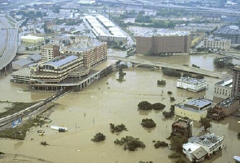
An example of this would be the early season storm Allison in 2001 that inundated Houston with floods and became famous for the Tropical Storm that caused extraordinary dollar amount damage. These types of scenarios are biggest with early season storms and late season storms vs a storm like Camille or Katrina that is a tightly would Hurricane without the additional problems of Spring Cold Fronts or early Fall Snow Storms like Atlas of TWC fame.
http://en.wikipedia.org/wiki/Tropical_Storm_Allison
"The low-level circulation dissipated, though the mid-level circulation persisted"
Another problem is raised when you read the discussion. Sometimes meteorologists argue endlessly over when the storm is a true Tropical Storm or a Baroclinic system or a Subtropical. As they move north and merge into the front they lose that pretty TS shape and look like large Hindenburg era dirigibles about to move SW to NE however somewhere in there is a center that is actually moving NNE and dragging with it the rest of the mother ship. See the discussion below on Allison.
"At 1200 UTC on June 5, the disturbance developed a broad, low-level circulation, and was classified as Tropical Storm Allison, the first storm of the2001 Atlantic hurricane season. Some intensification was projected, though it was expected to be hindered by cool offshore sea surface temperatures.[4] Due to the cold-core nature of the center, Allison initially contained subtropical characteristics. Despite this, the storm quickly strengthened to attain peak sustained winds of 60 mph (95 km/h), with tropical storm-force winds extending up to 230 miles (370 km) east of the center, and a minimum central pressure of 1000mbar.[2] The storm initially moved very little, and the presence of several small vortices from within the deep convection caused difficulty in determining the exact center location.[5] Later in the day, several different track forecasts arose. One scenario had the cyclone tracking westward into Mexico. Another projected the storm moving east towards southern Louisiana. At the time, it was noted that little rain or wind persisted near the center, but rather to the north and east.[6] Under the steering currents of a subtropical ridge that extended in an east–west orientation across the southeast United States,[5] Allison weakened while nearing the Texas coastline, and struck near Freeport, Texas with 50 mph (80 km/h) winds.[2] Inland, the storm rapidly weakened, and theNational Hurricane Center discontinued advisories early on June 6.[7] Shortly after being downgraded to a tropical depression, surface observations showed an elongated circulation with a poorly defined center, which had reformed closer to the deep convection.[8]"

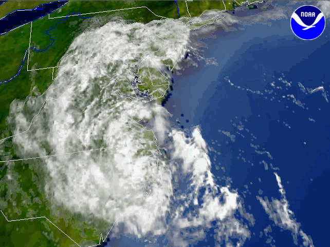
Again storms like this create their own unique problems. In the image above it was called Sub Tropical Allison even though the eye/center looked like a hurricane.
Also, people forget that the end game with Allison was over the Carolinas.
Here below is an image of the storm system over North Carolina.
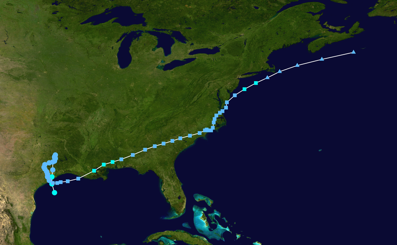
Below is the track of TS Allison in 2001... Look familiar other than its starting point was way further West than Karen.
Rainfall amounts from Tropical Storm Allison:

This is the problem. Even a weak tropical storm or an ex-tropical storm..not capitalized :) can still cause massive mischief from storm surge along the Gulf Coast where the dynamics of the underwater shelf makes them prone to huge storm surges for even small storms and then............inland flooding.

Now let's look at Karen specifically...
Karen's problems today are less from "dry air" and internal problems as to whether her heart (circulation center) is in the right place (underneath her convection spinning off to the East) and that is a story that will be played out over the next few days.

Yes she is in a bubble of dry air on either side of her. She also is having problems staying properly aligned, like many an October Tropical Storm.
Another factor is the water temperature in the Gulf of Mexico.
Any small anomaly can affect Karen IF she is a well developed storm and properly stacked.
It's called the Loop Current.. because it loops around..........
http://oceancurrents.rsmas.miami.edu/atlantic/loop-current.html
Read up on it.
Check back tonight when we will see what condition Karen is in and how if at all the model forecasts have changed. And, model forecasts change often especially with October Tropical Storms.
And, keep watching that trough and that strong WINTER STORM ATLAS as these weather systems are all out there on the map colliding in real time and since time began... Tropical Storms like Karen so often run away with the big bad Cold Fronts like a girl in love with a guy with an edge.
Stay tuned... the drama continues............
BobbiStorm's Bottom Line...
Never underestimate the power of "just a Tropical Storm" because if it's your home that gets flooded or was hit by a tornado in a feeder band... it will be the storm you remember for the rest of your life. I have a friend who waxes poetically in the style of Edgar Allen Poe every time a storm that bears any resemblance to Josephine forms. Her neighborhood was one of the ones that had tremendous destruction from the twisters that Josephine is remembered for by many.
http://news.google.com/newspapers?nid=1129&dat=19961008&id=4PRRAAAAIBAJ&sjid=EHADAAAAIBAJ&pg=6667,5292776
Josephine October 7th, 1996...
Note very well formed, but she pumped up HUGE amounts of rain mixing with colder weather moving down the site and she spawned tornadoes that did more damage than any land falling July Tropical Storm in Miami could ever do ....
North Florida is prime time real estate for tropical troubles from weather associated with Tropical Storms that make landfall far to the South or way to the North.
.gif)
So... never write off potential tropical trouble as "Just a Tropical Storm..."
She may have thrown off her pretty red coat that looked good on the Infrared, but on the Visible Imagery she is pumping... beautiful, spinning...

Besos Bobbi
Ps... Enjoy this wonderful video from when John Hope was alive and Mike Seidel was young :) and excellent discussion by Bill Keneely. How I miss the old TWC ... They did real discussion vs "WOW, WOW... DID YOU FEEL THAT WOW!!!" or rapping at 8 AM with rappers who are appearing later this week at some NBC sponsored event when people want to see WEATHER. It used to be ALL ABOUT WEATHER. Now, it's about weather and some entertainment thrown in.. how sexy mini dresses for the OCM gals and note most of the guys over 40 except for Jim are gone... unless they are WINTER WEATHER EXPERTS. It reminds of the old Channel 7 in Miami. I love Channel 7 that we think of as WSVN now days but in the old days Channel 7 would hype every news story into BREAKING NEWS!
Got to give it to Vivian Brown as she is still there at TWC... and Kim and a few others, but some are really there for entertainment purposes only ...
"Winter Storm Atlas is ploughing out of the Rockies RIGHT NOW"...
http://www.youtube.com/watch?v=p9eHxlKCv8Q
And... by the way the experts on TWC are still as expert as it gets...
posted by BobbiStorm @ 11:37 AM
![]()


0 Comments:
Post a Comment
<< Home