Worry Not on the 1st Hurricane of the Season...but the LAST... A look back at 1991 and 2012... Remember Grace?

The H storm is on the map and the countdown to a Hurricane in the Atlantic is up and running. Mind you Humberto looks stronger than they said at 8AM and would say it is at least 50mph currently. Strong storm. The details of the discussion are not all that important. It's far away in the land of the Cape Verde Islands and currently making landfall in ways and yet like the tree in the forest no one cares. All anyone wants to talk about is when the first hurricane will form.
Well...got to tell you after the 2012 Hurricane Season my bigger concerns are when the LAST Hurricane will form.
Want to know why?
I'll tell you why? I'll show you why...

Hurricane Sandy formed in LATE October.............the Halloween storm...
Things change fast in the tropics... patterns get thrown out the window when the pattern changes.
In 2012 at about this point in the season all we had was weak tropical storms and shallow hurricanes for a day or two. Mostly nothing to write home about. A bunch of weak, wet tropical storms crisscrossed the south and all the real tropical energy stayed south in the Caribbean. No really LONG trackers.

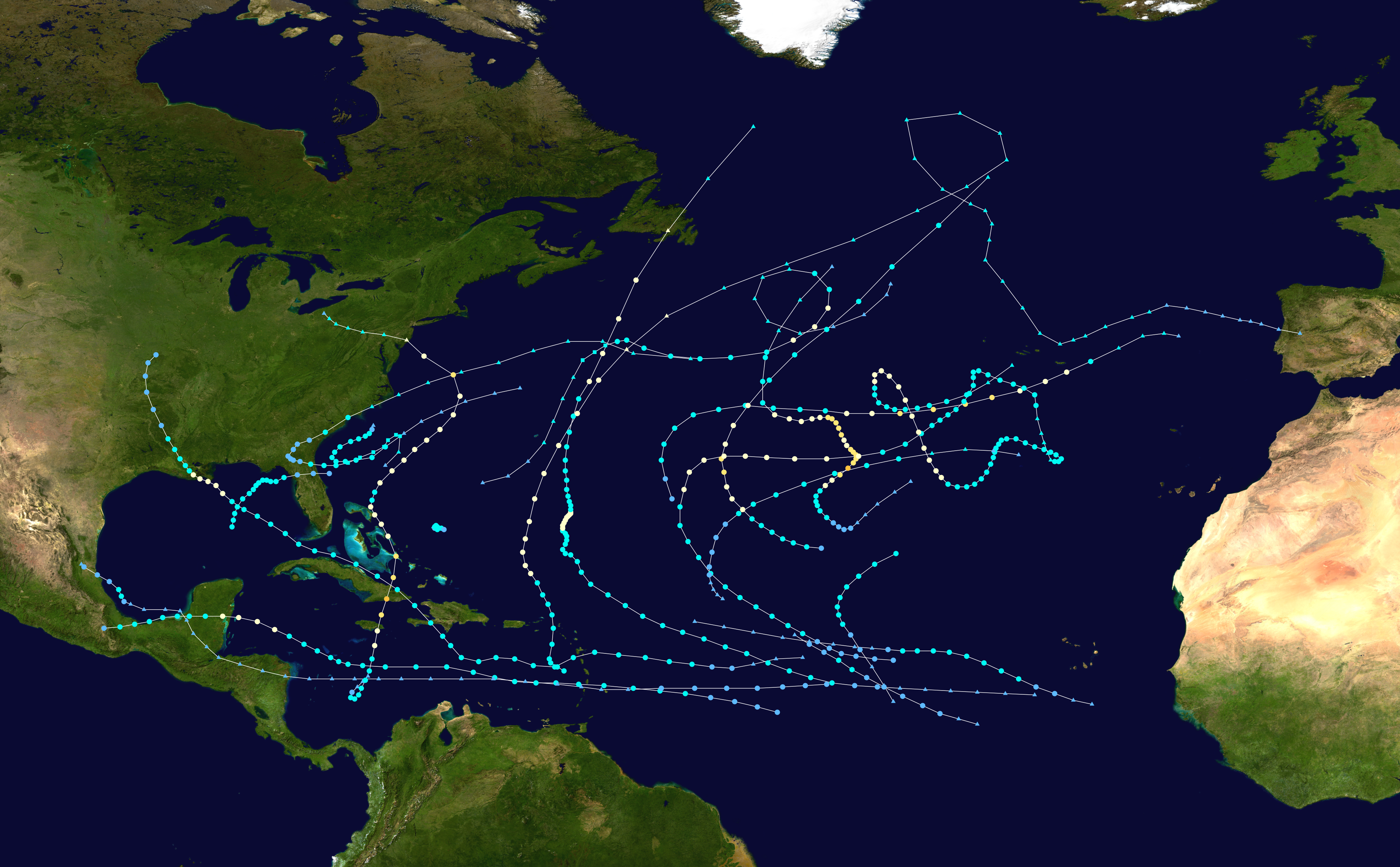
Cyclonebiskit posted these maps on wikipedia... sweet...
Notice all the storms that went north up the Atlantic vs going to Florida or Carolina? The East Coast looked safe from any real hard hurricane hit.
Things change even though they stay the same in some ways.
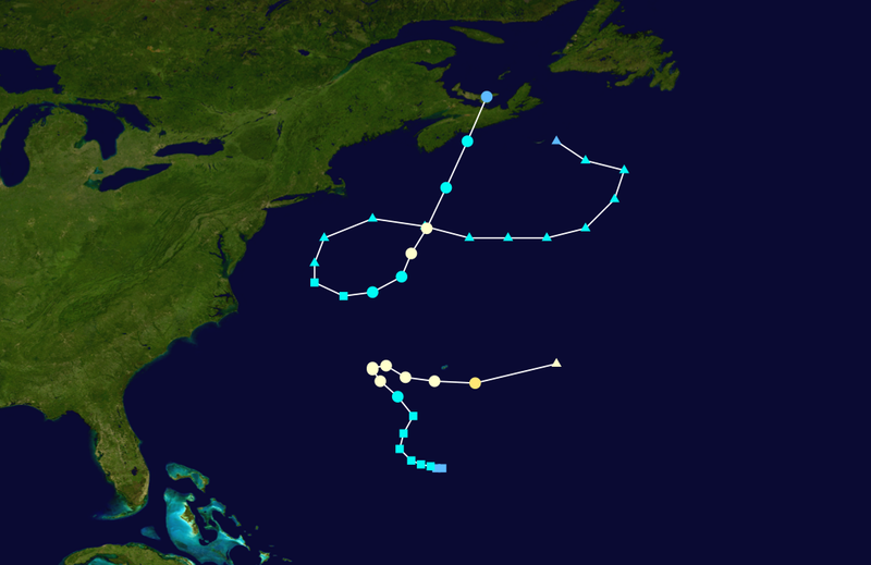
More storms in the Atlantic but oh my goodness what is that hurricane that got away and slammed hard into New Jersey and New York and changed the way we look at storms making landfall in New York City in almost November... Because in October everything changed.
Things do change..........you have to stay on top of the tropics and never assume that a weak start will bring a weak end.
These free form ink blots tell a late Autumn story of BOO....
The Perfect Storm... which sort of fed off of Hurricane Grace.
http://en.wikipedia.org/wiki/Hurricane_Grace_(1991) the season brought to you by Stephen King...
1991 was a relatively slow season. Tell that to Sebastian Junger who make a fortune writing the Perfect Storm or the actors who played in the movie.
http://en.wikipedia.org/wiki/1991_Atlantic_hurricane_season
Somewhere it began with a writer standing by the water...staring out at the ocean..raising their long arms out at the moon...the sea... the sea foam...the far away storm and the writer's mind that doesn't sleep trying to see out there...far out there.......into the mind of the storm.
Hurricane Bob.... another New England landfalling storm that affected the Atlantic Coast...and then nothing big....

It took 6 attempts to get to the C storm............think on that how often does that happen?
| 1 | Tropical Storm ANA | 29 JUN- 5 JUL | 45 | 1000 | - | |
| 2 | Tropical Depression 2 | 5- 7 JUL | 30 | 0 | - | |
| 3 | Hurricane-3 BOB | 16-29 AUG | 100 | 950 | 3 | |
| 4 | Tropical Depression 4 | 24-26 AUG | 30 | 0 | - | |
| 5 | Tropical Depression 5 | 28-31 AUG | 30 | 0 | - | |
| 6 | Hurricane-4 CLAUDETTE | 4-14 SEP | 115 | 944 | 4 | |
| 7 | Tropical Storm DANNY | 7-11 SEP | 45 | 998 | - | |
| 8 | Tropical Storm ERIKA | 8-12 SEP | 50 | 997 | - | |
| 9 | Tropical Storm FABIAN | 15-17 OCT | 40 | 1002 | - | |
| 10 | Tropical Depression 10 | 24-25 OCT | 25 | 0 | - | |
| 11 | Hurricane-2 GRACE | 25-29 OCT | 90 | 980 | 2 | |
| 12 | Hurricane-1 12 | 28 OCT- 2 NOV | 65 | 972 | 1 |
It's not about the beginning... it's often about when and how the season ends. Does it go out with whimper or a BANG?
| First system formed | July 2, 1991 |
|---|---|
| Last system dissipated | November 2, 1991 |
As for HUMBERTO in 2013... let's take the time machine back to the present...

WOW check that out... that's more than some wimpy 40 or 45 mph Tropical Storm if you ask me.. oh by the way large storms usually turn slower.
Look at the remnants of Gabrielle.... is she doing the Grace dance ??? Somethings going on there today and it started yesterday.
Another view...

That's Humberto on the far right...stage right...
The forecast is for Humberto to become a Hurricane..... see below from the NHC... is the H storm the Tatse of Honey that the NHC has been waiting for??
http://www.youtube.com/watch?v=bsKo_LtShsw
The MJO MOJO that starts the season that everyone predicted we would have???
http://www.ssd.noaa.gov/goes/east/eaus/avn-animated.gif

FORECAST POSITIONS AND MAX WINDS

INIT  09/0900Z 13.4N  22.8W   35 KT  40 MPH
 12H  09/1800Z 13.6N  24.3W   45 KT  50 MPH
 24H  10/0600Z 14.1N  26.2W   55 KT  65 MPH
 36H  10/1800Z 14.9N  27.8W   60 KT  70 MPH
 48H  11/0600Z 16.2N  28.7W   70 KT  80 MPH
 72H  12/0600Z 20.0N  29.5W   80 KT  90 MPH
 96H  13/0600Z 23.5N  30.5W   70 KT  80 MPH
120H  14/0600Z 25.2N  33.4W   60 KT  70 MPH
![[Image of 3-day forecast and coastal areas under a warning or a watch]](http://www.nhc.noaa.gov/storm_graphics/AT09/refresh/AL0913W_NL+gif/144505W_NL_sm.gif)
http://www.wunderground.com/blog/JeffMasters/archive.html?year=2013&month=08
"Greg Fishel @gbfishel2h
Regarding the hurricane season, NOAA stated on May 23 "There are no mitigating factors that we can see that will suppress the activity"
Greg Fishel asked a good question on Twitter yesterday...Bryan Norcross has asked the same question. Why when there were no mitigating factors int he forecast for this season...did we get nothing going until the middle of September? Good question..
It's a mystery novel that doesn't have the end written yet.... stay tuned...someone will figure it out.
As for the 2013 Hurricane Season... will it end all soft and sweet like a Carpenters tune?

Hurricane Seasons sometimes have surprises when we get into Fall and the Jack O Lanterns are out things to BOO in the not so tropical night.....................

A lot to think on today.................no real answers but lots of questions....
Bobbistorm's Bottom Line:
Expect an upgrade sooner rather than later on Humberto to Hurricane...
Besos Bobbi
Ps...Read a cute fortune cookie the other day. "Live in the past or learn from it'
Beware of those years when nothing can pull it together and there are a bunch of no neck storms barely able to maintain themselves. Remember 1991...look at the storms after Claudette...and then there was Grace..and the Perfect Storm.
 |
|
 |
|
 |
|
 |
|
 |
|
 |
|
 |
|
posted by BobbiStorm @ 9:46 AM
![]()


0 Comments:
Post a Comment
<< Home