Old Dorian... Can He Make Miami or Is He Off to Catch Some Fish in the Atlantic??

There is currently on Friday Morning a 30% Chance that the large, tropical thunderstorm
that is hovering over Miami and the Bahamas may develop into something more...
Another View...

So... the image below is what I have saved on my computer as "Yes we see it's there" which must be what most people at the NHC are thinking so an Invest is up... the circle is posted...recon has been canceled

If you look carefully at the VISIBLE you will see a few things.. one...whatever circulation there is...is to the north of the big round ball above the Miami area. Further off the coast and to the north is a small circulation trying to wrap and running out of time. Miami will get rain...as usual and maybe not as much as usual.
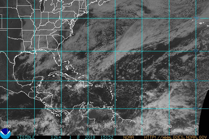
If you go out to the EAST towards where Africa would be ... you see polka dots in the ocean.. a lot of them. Almost looks like a black and white leopard here... that is AFRICAN DUST.. and oh by the way it is moving towards Miami's general direction.
As for "Dorian" as my brother would say flippantly "move along now, there's nothing to see here" but "Old Dorian" as Phil Ferro from Channel 7 in Miami calls him.... old like a salty ole fisherman in the Bahamas who never caught the big one but keeps on trying. Well, Phil says "OLD" but growing up near the docks in Miami that's how I picture him in my mind's eye. Worn cap low over his forehead, 7 days growth of whiskers yet not a full beard, stinks of cheap scotch and yesterday's tobacco.
Really most likely a case of OVERKILL as Jimmy Buffett sings..
http://www.youtube.com/watch?v=UM6PBhHz3qY
You can go to www.spaghettimodels.com and check out his current models .... seems Mike has him as "OLD DORIAN" too .. but what can you say about a system that has been with us for what seems like half of the Hurricane Season so far...

The picture of the world from far away shows us...a small red dot off the coast of Miami, an area of thunderstorms in the SW Carib (will probably be Hurricane Zebra in the Pacific...what are they up to now?) and an area of thunderstorms from a dying front off of the coast of the Carolinas.
As I have said for days............it is possible that the weak circulation center will travel north towards the area of troubled weather off the Carolina Coast and the rain may move west over Florida. Note the models currently go in two different directions. That COULD be the resolution of that question. Maybe.
Storms that do form close in can spin up fast and the NHC is taking an extra measure of precaution that many think is just ridiculous. This is almost surreal discussing why the NHC wouldn't fly in recon to see if it has a circulation on TWC. Seriously? They named this storm to begin with without recon, they can see it on the Miami Radar...they can be a little green and conserve the fuel and funds for REAL storms later this year and there WILL be REAL storms later this year and they WILL travel towards South Florida. You can take that to the bank.. a greater than 50% chance in my mind that South Florida will be under a REAL Hurricane Watch or Warning later this season.
Why bother with Old Dorian now? Because history teaches us what can happen tomorrow. Hurricane Beth formed in the same spot in 1971 as a weak Tropical Storm from rain that hovered over South Florida and ended up being a stronger storm in the North Atlantic.

Not saying that will happen, just showing how stranger things have happened ...so we err on the side of caution.
Newest model tracks this morning at 10 AM Friday:

I'll be back later when there is something definitive to report as to whether or not Old Dorian has caught that big fish he's been hunting for ...
Meanwhile... watch the local Miami Radar for any signs of spin or swirls... twitter your local National Weather Service online if you see anything...
Oddly, IF it starts to wrap and goes more to the North ... South Florida could get less rain. Funny, but real possibility.
Only time will tell... keep watching.
Besos Bobbi
@Bobbistorm on Twitter...
https://twitter.com/NWSMiami <--- miami...="" national="" nbsp="" p="" service="" weather="">
posted by BobbiStorm @ 6:58 AM
![]()


0 Comments:
Post a Comment
<< Home