Dorian Tries To Win Us Over AGAIN.... New Invest 91L...Same Old Dorian. 30% Orange Circle at 11 PM

The above is a image from the NHC that says that Dorian AKA 99L AKA 99L has come back to life
it has a 30% chance of reforming or forming depending on how they name it...
maybe.....
The image below is of the Eiffel Tower
maybe.....

The image at the top of the page has as much a chance of being a strong Tropical Storm hitting Miami...
as....
the pretty sunset picture of the Eiffel Tower is really in Paris...
And, a rose by any name is still a rose...
Dorian who went through the 99L name is now using 91L
Beginning to feel like a new show on the USA Network
You know I've been burned by Dorian before...
....having a hard time trusting him again
with his new screen name...
Where I took that there pretty sunset tonight :)

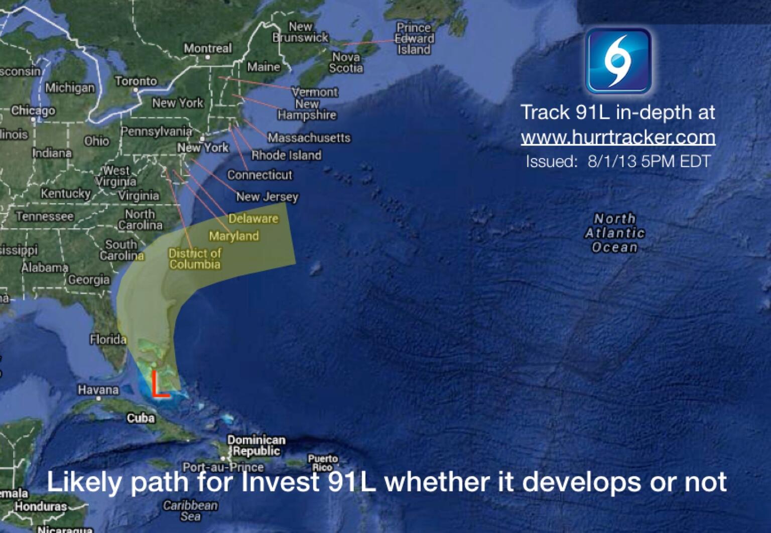
Right now Invest 91L is just an area of thunderstorms with some low pressure at the surface just off the coast of South Florida near Andros Island. Finally... pressures are lowering at the surface and yet that beautiful mid-level circulation has disappeared. Again, it takes a lot to make a tropical cyclone and often something had to give. Low pressure forming slowly and you need low pressure to have a named storm vs a "trough". And, it's about where they had predicted Dorian would be back when 91L was Dorian.
Remember back a week or so ago when they said that Dorian would move closer to Florida and then slide up along the coast towards the Carolinas, probably doing that turn just before land? Seems the models were right on the track though not on the intensity as Dorian fell apart, dressed up as 99L and then tried on a new set of dancing shoes with the name 91L. I am getting soooo tired of this.............honest, unless it comes to the coast of NC and I can watch it at the beach...
There is a lot of uncertainty in the models
Tracks at 11 PM are as follows:

I'm going to leave up a radar loop which you can watch tonight while I am sleeping and trust me I will not be dreaming on Dorian...
Notice to the East of Andros Island there is a swirl. Keep watching it.
And, convection is growing tonight...in the same area where surface pressures are dropping.
Nice blow up on the Funktop Loop... if that continues or you see green... they may up the chances later this evening above 30%.

It's close in and it's proximity to land warrants a higher level of attention.
Night time visible floater loop...

I'm not a big believe in this ... time will tell.
Note earlier I said it was an off the wall ... long shot... that it could move north and merge
with the mass of weather off the coast of Carolina...
a good call on my part even if I do think it's a long shot.
If there was a REAL system... it would move towards the trough..
Lows go to Lows..
Like attracts like
An early season Cape Verde Tropical System... an Early Out of Season Strong Front..
Only time will tell...
I'm not feeling the love Dorian..
Surprise me...

Will discuss the new Cape Verde Wave when it gets past Cousin Sal..
In Hurricane News there is a new model out from Carolina Coastal University named HUGO
HUGO stands for Hurricane Genesis and Outlook Project
Carolina Coastal University's new Hurricane Modeling Project
HUGO predicts we will have one hurricane on the Carolina Coast this year
and one hurricane on the Gulf Coast...
Keep Watching... Sweet Tropical Dreams
BobbiStorm
Ps if he forms more to the South he has more running room...
(read previous blog to really understand the situation here...)

ZCZC MIATWOAT ALL
TTAA00 KNHC DDHHMM

TROPICAL WEATHER OUTLOOK
NWS NATIONAL HURRICANE CENTER MIAMI FL
800 PM EDT THU AUG 1 2013

FOR THE NORTH ATLANTIC...CARIBBEAN SEA AND THE GULF OF MEXICO...

1. DISORGANIZED THUNDERSTORMS CONTINUE ALONG A TROUGH OF LOW
PRESSURE...THE REMNANTS OF DORIAN...LOCATED BETWEEN SOUTH FLORIDA
AND THE BAHAMAS.  SURFACE PRESSURES ARE FALLING...AND SOME
DEVELOPMENT OF THIS SYSTEM IS POSSIBLE BEFORE UPPER-LEVEL WINDS
BECOME UNFAVORABLE IN A DAY OR TWO. THIS DISTURBANCE IS FORECAST TO
MOVE TOWARD THE NORTH AND NORTHWEST...BRINGING CLOUDINESS...
SHOWERS...AND GUSTY WINDS TO PORTIONS OF THE NORTHWESTERN BAHAMAS
AND THE COASTAL WATERS OF SOUTHEASTERN FLORIDA ON FRIDAY AND
SATURDAY. AFTER THAT...THE DISTURBANCE IS EXPECTED TO MOVE TOWARD
THE NORTH-NORTHEAST AND BECOME ASSOCIATED WITH A FRONTAL TROUGH
OFFSHORE OF THE EASTERN UNITED STATES. THIS SYSTEM HAS A MEDIUM
CHANCE...30 PERCENT...OF BECOMING A TROPICAL CYCLONE DURING THE
NEXT 48 HOURS...AND A MEDIUM CHANCE...30 PERCENT...OF BECOMING A
TROPICAL CYCLONE DURING THE NEXT 5 DAYS.

FIVE-DAY FORMATION PROBABILITIES ARE EXPERIMENTAL IN 2013.  COMMENTS
ON THE EXPERIMENTAL FORECASTS CAN BE PROVIDED AT...

HTTP://WWW.NWS.NOAA.GOV/SURVEY/NWS-SURVEY.PHP?CODE=ETWO

FORECASTER BLAKE
More Models... I like this one better!!
Would take me to Wilmington over the weekend if that track verifies... not holding my breath.
Dorian is going to have to do more than get some surface low pressure& produce some swirls!
posted by BobbiStorm @ 8:33 PM
![]()


0 Comments:
Post a Comment
<< Home