Yellow Circle Grows...still 10% N Gulf Coast GOM on watch...SHORT TERM... MAIN CHANGE IN SHORT TERM FORECAST SCENARIO FROM 12 HOURS AGO WAS TO RAISE RAIN CHANCES FOR TODAY ACROSS THE AREA. WITH WEAK SURFACE LOW OFF THE COAST...SURFACE CONVERGENCE IS MORE FAVORABLE FOR CONVECTIVE DEVELOPMENT THAN WAS ANTICIPATED YESTERDAY. POPS WILL RANGE FROM LIKELY EAST TO AROUND 40 PERCENT WEST...WHICH IS CONSIDERABLY HIGHER THAN PREVIOUS FORECAST. THIS IS SUPPORTED BY PRECIPITATION DISTRIBUTION ON LOCAL 3KM WRF. WE ARE ALREADY SEEING SOME ROTATION ON CELLS ALONG THE COAST...SO WATERSPOUTS/BRIEF TORNADOES CANNOT BE RULED OUT CLOSE TO THE COAST. MID LEVEL SHEAR AND LOW LEVEL LAPSE RATES WILL BE SUFFICIENT FOR AT LEAST MINOR POTENTIAL FOR SEVERE WEATHER EACH OF THE NEXT THREE DAYS...GENERALLY AT SPC SEE TEXT PROBABILITY LEVELS. CURRENT MODELS DO NOT TAKE UPPER TROF QUITE AS FAR WESTWARD AS EARLIER PROGS...WHICH MAY SERVE TO FOCUS THE HEAVIEST RAIN JUST EAST OF OUR AREA INSTEAD OF OVER THE AREA. OTHER THAN TODAY...HAVE NOT MADE MANY CHANGES IN SHORT TERM POPS. BEST CHANCES FOR RAIN AFTER TODAY WILL HOLD OFF UNTIL FRIDAY...WHEN LIKELY POPS WILL BE NECESSARY ACROSS MUCH OF THE AREA. TEMPERATURES WILL BE SEVERAL DEGREES BELOW NORMAL THROUGH THE PERIOD. 35 && .LONG TERM... MAIN PORTION OF UPPER TROF LIFTS INTO THE OHIO VALLEY SATURDAY NIGHT WITH A WEAKER PIECE OF AN EASTERLY WAVE REACHING THE WESTERN LOUISIANA COAST SUNDAY NIGHT OR MONDAY MORNING. THIS WILL MAINTAIN RAIN CHANCES...ALTHOUGH WITH LESS AREAL COVERAGE THAN EXPECTED FRIDAY AND SATURDAY. WILL ALSO BE WATCHING AN EASTERLY WAVE WHICH IS WELL DEPICTED BY BOTH GFS AND ECMWF. THE WAVE IS EXPECTED TO MOVE THROUGH THE FLORIDA STRAITS MONDAY OR MONDAY NIGHT.
A compare and contrast on how the Yellow 10% circle around the Yucatan has gotten larger. And, I seem to be stuck with the song in my mind "the wheels on the bus go round and round" or in this case get larger and larger... The circle grows and the real concern seems to be immediately with the upper part of this newly expanded circle for a small system to spin up fast along the Northern Gulf Coast later this week...as in maybe Friday

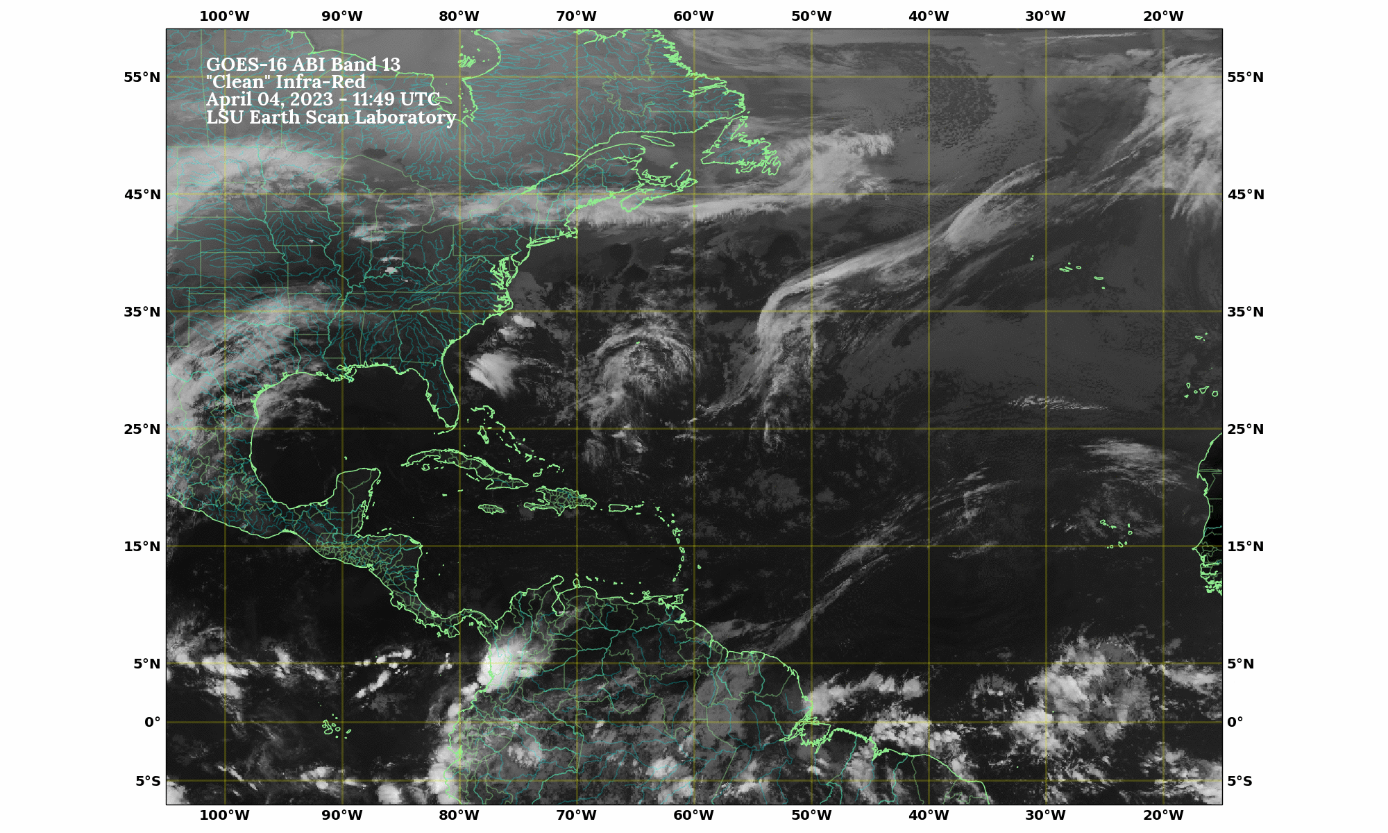
Note there is currently rain training in there as I write this not yet connected with the Yucatan Low Pressure Trough ...which for now is what it really is.

The NWS discussion out of SE Louisiana shows us some clues as to what may or may not happen:
(I'm highlighting the parts that are important to us)
SHORT TERM...
MAIN CHANGE IN SHORT TERM FORECAST SCENARIO FROM 12 HOURS AGO WAS
TO RAISE RAIN CHANCES FOR TODAY ACROSS THE AREA. WITH WEAK SURFACE
LOW OFF THE COAST...SURFACE CONVERGENCE IS MORE FAVORABLE FOR
CONVECTIVE DEVELOPMENT THAN WAS ANTICIPATED YESTERDAY. POPS WILL
RANGE FROM LIKELY EAST TO AROUND 40 PERCENT WEST...WHICH IS
CONSIDERABLY HIGHER THAN PREVIOUS FORECAST. THIS IS SUPPORTED BY
PRECIPITATION DISTRIBUTION ON LOCAL 3KM WRF. WE ARE ALREADY SEEING
SOME ROTATION ON CELLS ALONG THE COAST...SO WATERSPOUTS/BRIEF
TORNADOES CANNOT BE RULED OUT CLOSE TO THE COAST. MID LEVEL SHEAR
AND LOW LEVEL LAPSE RATES WILL BE SUFFICIENT FOR AT LEAST MINOR
POTENTIAL FOR SEVERE WEATHER EACH OF THE NEXT THREE
DAYS...GENERALLY AT SPC SEE TEXT PROBABILITY LEVELS.
CURRENT MODELS DO NOT TAKE UPPER TROF QUITE AS FAR WESTWARD AS
EARLIER PROGS...WHICH MAY SERVE TO FOCUS THE HEAVIEST RAIN JUST
EAST OF OUR AREA INSTEAD OF OVER THE AREA. OTHER THAN TODAY...HAVE
NOT MADE MANY CHANGES IN SHORT TERM POPS.
.LONG TERM...

MAIN PORTION OF UPPER TROF LIFTS INTO THE OHIO VALLEY SATURDAY
NIGHT WITH A WEAKER PIECE OF AN EASTERLY WAVE REACHING THE WESTERN
LOUISIANA COAST SUNDAY NIGHT OR MONDAY MORNING. THIS WILL MAINTAIN
RAIN CHANCES...ALTHOUGH WITH LESS AREAL COVERAGE THAN EXPECTED
FRIDAY AND SATURDAY. WILL ALSO BE WATCHING AN EASTERLY WAVE WHICH
IS WELL DEPICTED BY BOTH GFS AND ECMWF. THE WAVE IS EXPECTED TO
MOVE THROUGH THE FLORIDA STRAITS MONDAY OR MONDAY NIGHT.
POINT OF THE STORY HERE.... the wave that will travel across South Florida that is not
being talked about much will move into the Gulf and might be a problem there... The moisture
from this low pressure trough could connect with a real west bound wave.
Something may develop in the Gulf but what it will be we aren't sure. Might be some sort of hybrid or cold core system with tropical rain embedded in it. Another similar system my flare up in the long term from the same area over the Yucatan. The yellow circle is up on the Yucatan because it is a general area with convection (rain) and low pressure attached to it...but without any circulation or any "center" so we watch...
This is the nitty gritty discussion from the NHC in their Tropical Weather Discussion:
...DISCUSSION...

GULF OF MEXICO...
BROAD UPPER TROUGH COVERS THE GULF N OF 21N W OF 88W EXTENDING
FROM AN UPPER LOW OVER THE UPPER MISSISSIPPI VALLEY AND
SUPPORTING A SURFACE TROUGH THAT AT 03/0900 UTC EXTENDS INTO THE
GULF OVER SE LOUISIANA NEAR 29N90W AND CONTINUES TO 24N94W WITH
SCATTERED SHOWERS/ISOLATED THUNDERSTORMS WITHIN 60/75 NM EITHER
SIDE OF THE TROUGH N OF 26N. SCATTERED SHOWERS AND POSSIBLE
ISOLATED THUNDERSTORMS ARE FROM 21N-26N W OF 95W TO INLAND OVER
NE MEXICO. AN UPPER RIDGE EXTENDS FROM THE NW CARIBBEAN ACROSS
THE W TIP OF CUBA THEN OVER THE FLORIDA PENINSULA TO NEAR LAKE
OKEECHOBEE. A SURFACE TROUGH IS BENEATH THIS UPPER RIDGE
EXTENDING FROM 25N83W ACROSS CUBA NEAR HAVANA INTO THE NW
CARIBBEAN. THE UPPER RIDGE IS PROVIDING DIFFLUNCE ALOFT TO
GENERATE SCATTERED SHOWERS/ISOLATED THUNDERSTORMS E OF 88W TO
OVER FLORIDA. A THIRD SURFACE TROUGH EXTENDS FROM 22N88W TO
INLAND OVER THE W PORTION OF THE YUCATAN PENINSULA WITH
SCATTERED SHOWERS/ISOLATED THUNDERSTORMS SE OF LINE FROM 25N88W
TO S MEXICO IN THE BAY OF CAMPECHE NEAR 19N95W INCLUDING THE
YUCATAN PENINSULA. SURFACE TROUGH OVER CUBA WILL MOVE W ACROSS
THE YUCATAN CHANNEL AND YUCATAN PENINSULA INTO THE FAR SW GULF
LATE TODAY THEN DRIFT W TOWARD THE COAST NEAR VERACRUZ THROUGH
FRI BEFORE DISSIPATING. THE SURFACE TROUGH IN THE N GULF WILL
DRIFT ACROSS THE NW GULF THROUGH LATE FRI IN PHASE WITH THE
TROUGH OVER THE SW GULF. A WEAK LOW PRESSURE AREA MAY FORM IN
THE NW GULF BY LATE SAT AND DRIFT NW THROUGH SUN.
Will the circle come unbroken or be upgraded to a large chance of development? Stay tuned..
http://www.youtube.com/watch?v=wx9KkYB_Xq0
The models have problems closing off the circle for now, but the beauty of the models is there is always another run in a few hours.
As for Miami...or as I think of it MYami...

Put it in motion it changes everything...or not... More moisture trains in from the Yucatan up into the Gulf Coast including South Florida as a small wave moves west into the messy trofiness ;)

And want to note here this is STILL a TROUGH... FRONTAL BOUNDARY ...call it whatever you want that has been draped across the map for the last several weeks and should that continue it could become a conveyor belt to transport anything that forms in the Caribbean north. Also, one last comment on this new, bigger, better circle it could have multiple low pressure cells spin up and any of those could try and form something and models change often in real time. So, keep watching. Nothing here is set in stone it is a Low Pressure Trough with a Big Yellow Circle with only 10% chances for now...
Besos Bobbi
Ps... A note on North Carolina. Chapel Hill is having a Live Press Conference on TV regarding the historic flooding in low lying areas around Chapel Hill. I mention this because UNC is one of those favorite schools for Miami kids who want to go up north but still stay down south. They cannot take any more water and they know more water (rain) is on the way, they want everyone to stay vigilant watching the weather and staying informed. "5 to 7 inches in a 24 hour period.. low lying areas had severe flooding. Families and businesses have been damaged and displaced. "
The ground is saturated and because of daily rainstorms not able to dry out. They are especially worried on any wind storm of any kind that could bring down more trees and do more damage. Wind storm as in "gust front" "straight line winds" and I'm thinking even worse another tropical system like the one we had earlier in the summer when Andrea came through here..
Over 130 "living units" are not livable currently. There are a lot of cute apartment villages there that are used by students and people who attend UNC. Actually, the UNC gym was partially under water ...
1996 has been mentioned as an analog year for this present 2013 Atlantic Hurricane Season and there are several similarities so far in real time. It might be worth a read here to check up on the Summer that led up to that historic year in Hurricane History..especially with regard to Carolina.
http://www.cpc.ncep.noaa.gov/products/special_summaries/96_4/
"Most of the central and eastern United States experienced a wet and cool Summer (June - August) while excessive heat, minimal precipitation, and expansive wildfires affected much of the West"
If that doesn't make you go hmmmnnnn ...what will?
A look at the 1996 Hurricane Season shows us two things. We had strong Atlantic storms that traveled west around the huge high and then they tangled with the trough monster that was lying across the East coast giving us Bertha and Fran and several which just missed the coastline. Note the islands got slammed.

posted by BobbiStorm @ 7:20 AM
![]()


0 Comments:
Post a Comment
<< Home