70th Anniversary of the FIRST Flight into a Hurricane... Invest 98L Still a Red Circle at 11PM..

First off... Invest 98L was not upgraded to a Tropical Depression despite the signature of a closed low on satellite imagery that is often used to determine such things. They wrote a short discussion about how the Tropical Surface Low has Gale Force winds ... but is lacking convection. Lord have mercy.. someone needs to be the once and future Dorian to get some rain in that moisture bubble of his...
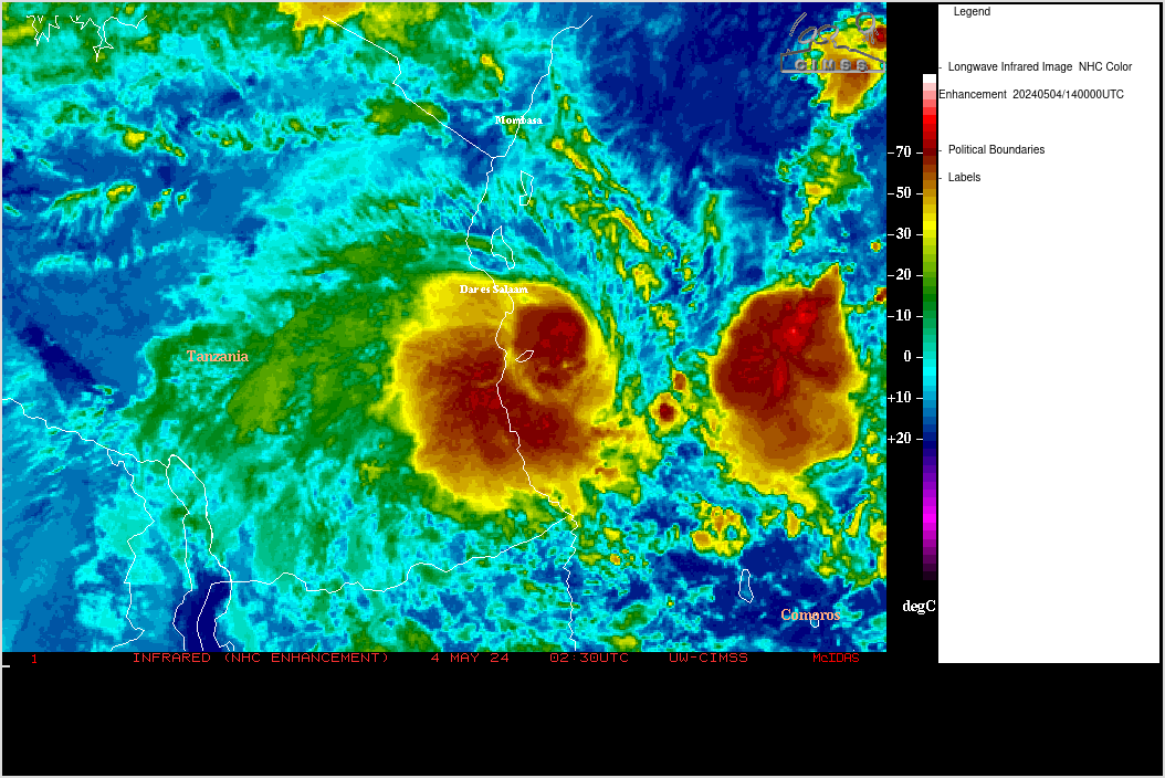
The above image shows the wind barbs in all directions around what appears to be a closed low pressure system at the surface. Yet, the NHC upped it's chances from 60 to 70% which is a stair step process climbing the ladder. Looks good.. loses a bit, looks good again.. etc.

It's a process. The NHC makes that call so for now it's a Red Circle with a low pressure system attached that appears to be closed and there are Gale Force winds at the surface... but not a lot of rain..or not enough rain for an upgrade.
Discussion tonight in their special statement.. usually they don't say anything at 11 PM, but everyone was waiting so... they spoke. Mixed signals if you ask me personally.
"1. SATELLITE-DERIVED WIND DATA INDICATE THAT THE SURFACE LOW PRESSURE
SYSTEM LOCATED ABOUT 150 MILES SOUTHWEST OF THE CAPE VERDE ISLANDS
IS PRODUCING WINDS TO NEAR GALE FORCE.  HOWEVER...THE ASSOCIATED
THUNDERSTORM ACTIVITY REMAINS SOMEWHAT LIMITED AND HAS NOT YET BEEN
PERSISTENT ENOUGH FOR THE LOW TO BE DESIGNATED AS A TROPICAL
CYCLONE.  IF THE THUNDERSTORMS INCREASE AND PERSIST...THEN THE LOW
COULD BECOME A TROPICAL DEPRESSION OR TROPICAL STORM ON WEDNESDAY
AS IT MOVES WEST-NORTHWESTWARD AT ABOUT 20 MPH.  THIS SYSTEM HAS A
HIGH CHANCE...70 PERCENT...OF BECOMING A TROPICAL CYCLONE DURING
THE NEXT 48 HOURS."
You be the judge, but warning you... the NHC gets the call.
Look at that bottom side... looks like bands forming. Yes, the north side is dry..we know that.
So, while we wait a little longer... I wanted to share a very well written and interesting piece of history from the AOML Blog about the FIRST flight into a Hurricane. Note.. it was not a "planned" flight and in my opinion would make one heck of a movie.
I'm going to post the link..as well as the article itself as nothing has been more important to our early understanding in those pre-satellite days of how hurricanes work as the work of early Hurricane Hunters.

Please read, please share and please remember it next time you hear someone say casually "They are sending in recon tomorrow" ... remember U.S. Army Air Force Lt. Col. Joseph Duckworth and his historic flight into a hurricane. I can only wonder who would play him today in the movie.

Article Below and leaving some links to read while you ignore Invest 98L and let it do it's thing. I would think it should get an upgrade to TD status or TS status, but it's not my call and he's going to have to pull himself together and impress someone at the NHC by maintaining his convection throughout the night!
Sweet Tropical Dreams
Bobbi
(PS..thanks Neal, you're awesome)
http://noaahrd.wordpress.com/ (a great link to save and read often!!)
"July 27th marks the 70th anniversary of (then) U.S. Army Air Force Lt. Col. Joseph Duckworth’s first deliberate flight into the eye of a hurricane. This historic event inaugurated the era of aircraft reconnaissance into tropical cyclones which greatly enhanced our understanding and forecasting of these storms.
Duckworth had been an Eastern Air Lines pilot prior to World War II and was well-versed in flying on instruments only. Since many military aircraft prior to the War lacked the instrumentation necessary for night or bad-weather flying, Army Air Force instructors lacked the skills necessary to teach instrumentation flying to air cadets. When reservist Duckworth was called up in 1940, he was assigned the task of teaching these students instrument flying and wrote many of the instructional manuals on the subject.
By 1943 he was working at Bryan Army AirField in Texas, teaching mostly British pilots how to fly on instruments. (It was Royal Air Force policy to fly their bombing missions at night to reduce casualties.) On July 27th, all flying classes were cancelled when a hurricane unexpectedly hit Galveston to the southeast of Bryan. Some say it was on a bet, but it may have just been on a whim, but with his day free, Duckworth decided to fly his AT-6 “Texan” trainer aircraft into the storm. With navigator Lt. Ralph O’Hair along, he encountered moderate turbulence but succeeded in finding the eye to the west of Houston. Upon his return to Bryan Field, the base meteorologist Lt. William Jones-Burdick insisted on being taken up into the storm. So Duckworth headed out again while the weather officer rode in the back seat jotting down notes.
Although Duckworth was in trouble for taking the unauthorized flights, his superiors finally decided it was better to give him a medal rather than a reprimand. His mission proved it was possible to fly an aircraft into a hurricane and even locate its eye. As a result, there were several other flights into tropical cyclones later that year, including a flight into a hurricane east of Miami in mid-August in which real-time observations were relayed to the Miami Hurricane Warning Center to inform their warnings for the first time."
****
Another link from a different article:http://jayssouth.com/mississippi/hurricanehunters/
posted by BobbiStorm @ 8:52 PM
![]()


0 Comments:
Post a Comment
<< Home