What's a DERECHO You Ask? Sometimes I wonder if Andrea was a NE bound derecho ;)

That line forming on the radar...the "ball" is a derecho possibly coming together.

Derechos are the holy grail of bored meteorologists on days when there are no Twisters or Hurricanes to talk about and even when they are you can get any meteorologists attention by softly, coyly whispering derecho in their ear. They will sit up like you are wearing the latest negligee from Victoria Secrets and holding their favorite dark lager.
Try it sometime if yo don't believe me...
de·re·cho
/dāˈrāCHō/NounA line of intense, widespread, and fast-moving windstorms and sometimes thunderstorms that moves across a great distance and is characte...
But, step back because they may jump or knock over their coffee and stop playing a video game or staring at meaningless loops in the Caribbean where nothing is happening because suddenly something IS happening up in the Midwest ...
| WHAT IS A DERECHO? |
A derecho is a widespread severe wind event resulting from persistent and violent outflow from a MCS (Mesoscale Convective System). The derecho environment includes dry mid-levels winds that are ingested into a squall line or a segment of a squall line. The forward motion of the storm along with an intense downdraft produced by negative buoyancy via evaporational cooling brings down momentum from the middle levels of the storm to the surface.
A severe wind is one with wind speeds of 50 knots (58 miles per hour) at the surface. In a derecho these severe winds encompass a distance of at least 400 km (250 miles) either out ahead of or along a squall line MCS. The length of time the severe winds last can be particularly damaging. While a severe thunderstorm may produce severe convective wind gusts that last for several minutes at a point location, derecho wind can last 30 minutes or longer. Derechos can be tracked from radar and severe weather reports while they are occurring since severe weather reports will be given in sequence as the derecho traverses along.
In the way of Superman ...Derechoes can move :"faster than a speeding bullet more powerful than a locomotive"
Sometimes I muse on whether Andrea was a NE bound Tropical Derecho vs a Tropical Storm, but I really don't want to get laughed out of the weather community. In ways it did act like one....
Today's Superman Storm is going to be forming ...possibly forming...along a line in the Midwest and might make it as far East as Takoma Park, Maryland... heck it might even make it to the shore..
So, while there is nothing specific happening in the tropics today and there is a whole lot of heat going in across the country where temperatures may top out above 90 for the first time this summer... a DERECHO might be forming so it's an A+ Weather Day in the world of weather people everywhere.
What can a DERECHO really do you ask?

A whole lot of damage over a wide spread area in a short period of time.. a lot like Andrea.
Link to the article for that picture is here... read up on it. You too can sound professional tonight if one forms in your area and people ask "what was that?" you can say..."Oh, THAT was a DERECHO" ;)
http://www.srh.noaa.gov/jetstream/derechos/derecho_past.htm Of course it's the NWS and not me..I'm going to explain it more like it is.. "the Holy Grail" of many meteorologists. Why? Happens less often than tornadoes, blizzards and hurricanes. It's a "perfect storm" of alignments meteorologically ..sort of like a cosmic event for astronomers...yet harder to predict. They are so rare that the spell checkers don't recognize the word and keep asking me if I mean "Jericho" or "drench" ... seriously.........
Read on and you may be hooked as well..
http://www.spc.noaa.gov/misc/AbtDerechos/derechofacts.htm
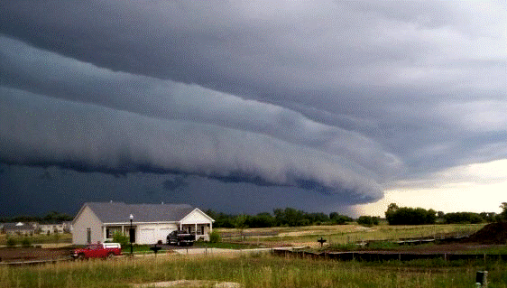
Gust front "shelf cloud" (or "arcus") on the leading edge of a derecho-producing convective system. The photo was taken on the evening of July 10, 2008 in Hampshire, Illinois as the storm neared the Chicago metropolitan area. The derecho had formed around noon in southern Minnesota. (Courtesy of Brittney Misialek)
Now you see what all the fuss is about?
So, keep those weather radios on and check your cell phone APPS for warnings and updates and keep looking up if you live in the areas that might be affected by this very uncommon weather event. And, if you are getting ready to go to the beach and your boyfriend doesn't notice you are wearing the latest bikini from Victoria Secrets just blame it on the Derecho and oh by the way........... they affect girl storm chasers as much as they do guys... it's just more fun to make fun of the guys cause they really DO have a THANG for Derechos.
Oh and if you miss today's derecho...there is another chance tomorrow.

Gotta go... things do to do ... places to go and people to meet today and........am gonna be watching the radar and the satellite loops just in case this derecho pans out :)
Besos Bobbi
Ps...low, low chance of something forming in the Gulf at the tail end of a front but nothing to write home about when a derecho is on the board... can write about that tomorrow...
http://www.spaghettimodels.com/ <--- :="" any="" but="" check="" especially="" it="" kind="" of="" out="" p="" the="" to="" tropical="" watch="" weather="">
posted by BobbiStorm @ 7:00 AM
![]()


0 Comments:
Post a Comment
<< Home