Andrea and a A Look Back at Hurricane Fran in NC in 1996

A lot to talk about today and trying to hit many subjects here and stay on target at the same time.
The small core of Tropical Storm Andrea is moving NE through South Carolina ...up I-95 on her way to North Carolina and then Virginia.
8:00 AM EDT Fri Jun 7
Location: 33.4°N 80.2°W
Moving: NE at 28 mph
Min pressure: 996 mb
Max sustained: 45 mph
The effects of the storm are mostly being felt "East of 95" which is a cultural boundary round these parts, but also a meteorological one and also geologically but that's storm for another day.
The BBQ sauce changes at I-95, west of I-95 it is something but it's not what I grew up with as BBQ sauce. The land begins to change, a rise is felt in the land and you move from coastal plain to the Piedmont. Weather is worse at the beach and worse in the mountains near Asheville, the Piedmont is sort of boring...but not always. I like to think of everything west of I-95 as Eastern Tennessee and I am sure I could be right on that in ways.
Andrea is here as seen on the WIND map.
http://hint.fm/wind/

From where I view it the center is very close to the coast and further to the left (EAST) than it was supposed to be. I'm getting rain in Raleigh, heavy ...steady rain, very little wind. The Oaks are wet this morning in Raleigh.

A branch fell down last night in the driveway and had to be moved aside so we could get out this morning.


Notice the path now veers away from the NJ and NY are and moves more out to sea.
Note Andrea is hugging the coast and moving north into an area that is already water logged from rain the last few days.

As for the yellow invest, when it stops looking like it will hit Miami and South Florida.. I'll start to ignore it a bit more.
And, currently the storm is chugging her way up I-95 or a bit east of I-95. I bet a ride over the Chesapeake Bay Bridge today would be a wild trip. Current conditions are:
http://www.cbbt.com/weather.html
So, what I would really like people to think about today is that in September, a similar storm taking the same path would and could cause untold damage...hard to even imagine over a large swath of the US.
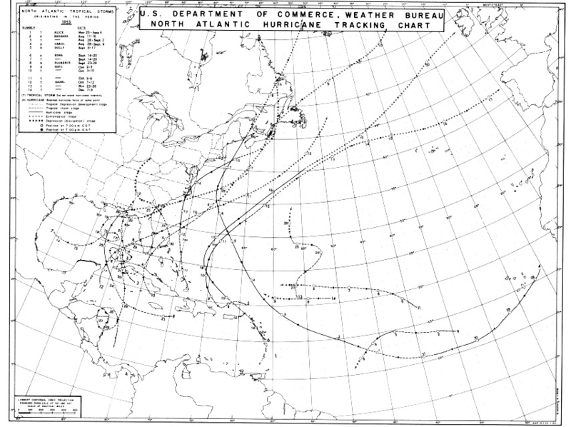
Joe Bastardi has been screaming the famous hurricane sisters named Barbara, Carol and Edna ran up the coast in 1953. He has felt most of this year that this coming year could be a replay of that period in history and that Hurricane Sandy was a warning for us that patterns are changing and we are going back to a period of active East Coast Storms.
Barbara, Carol and Edna all affected populated areas and areas "up north" got storms that we usually only think Nola and Miami will get.
The 1953 Atlantic hurricane season was the first time an organized list of female names was used to name Atlantic storms. It officially began on June 15,[1] and lasted until November 15,[2] although activity occurred both before and after the season's limits. It is one of only four seasons to have a pre-season storm and a post-season storm, the others being the 1887, 2003, and 2007 seasons.[3] The season was active with fourteen total storms, six of which developed into hurricanes; four of the hurricanes attained major hurricane status, or a Category 3 or greater on the Saffir-Simpson scale.
The strongest hurricane of the season was Carol, although by the time it struck Atlantic Canada it was much weaker. Both hurricanesBarbara and Florence struck the United States; the former crossed the Outer Banks and impacted much of the east coast, and Florence struck a sparsely populated region of the Florida Panhandle without causing much damage. Bermuda was threatened by three hurricanes within two weeks. In addition to the hurricanes, Tropical Storm Alice developed in late May and left several fatalities in Cuba. The final named storm of the season, Hazel, produced additional rainfall in Florida after previous flooding conditions. There were several unnamed storms, the last of which dissipated on December 9.
And in 1954, a year later, the East Coast was attacked again...
"The 1954 Atlantic hurricane season caused over $750 million in damage,[nb 1] the most of any season at the time. The season officially began on June 15, and nine days later the first named storm developed. Hurricane Alice developed in the Gulf of Mexico and moved inland along the Rio Grande, producing significant precipitation and record flooding that killed 55 people. Activity was slow until late August; only Barbara, a minimal tropical storm, developed in July. In the span of two weeks, hurricanes Carol and Edna followed similar paths before both striking New England as major hurricanes.[nb 2] The latter became the costliest hurricane in Maine's history.
In late September, Tropical Storm Gilda killed 29 people after drenching northern Honduras. A tropical depression in early October was captured by a high-altitude photograph on a rocket, thus producing the first large-scale image of a tropical cyclone. The strongest and deadliest hurricane of the season was Hurricane Hazel, which killed thousands in Haiti before striking near the North Carolina/South Carolina border in October. It caused heavy damage in the United States before becoming extratropical and affecting Ontario. Intense rainfall affected Toronto with severe flooding, leaving significant damage. The season officially ended on November 15, although another hurricane named Alice developed on December 30 to the northeast of the Lesser Antilles; it lasted until January 6 of the following year. In total, there were 11 tropical storms, 8 hurricanes, and 3 major hurricanes."

I guess they decided using Barbara every year was a bad idea and dropped that storm like a hot potato. Then again..............it was used in the EPAC this year and maybe that's how we got here..

It's a funny trivia fact that you can always tell how old someone is in the Raleigh area when they either flashback to Fran or talk on Hazel when a tropical system is forecast to go inland and not stay at the beach like it's supposed to in Wrightsville, Beach.-. Of course, some people...they just don't shut up about Hazel. The above is a pic of two of the many vehicles that got away during Fran.
Why am I mentioning this? Because I think it's important to highlight damage from a storm that most people never hear about. There I was in 1996, my first real hurricane season online...and all anyone did was speak about Wilmington Beach and Fran as the NC coast was the place to be for storm chasers. Now, about fifteen years later ...give or take... I'm living in North Carolina, remarried and all I ever hear about is Hurricane Fran and I smile and giggle a bit to myself how karmic that worked out oddly. As if it was part of the original plan...
 Today the major concern on the local news was not the few branches down or the possible storms later, but the fact that there is water running in Crabtree Creek. I'm from Miami, I expect water to be "running in the creek" but around here it scares everyone as they remember previous flooding in what is really geologically known as Crabtree Valley which is a slight indention in the land where water can pool and back in the early 1970s someone thought it was a bright idea to put a big mall there. Sort of like Aventura in Miami which was built in a swampy area at the north end of Biscayne Bay. Must have been a lot of that logic going around, almost wonder what they were smoking when they came up with the idea to find cheap land no one else wants and build on it. Oh .. it might flood.. probably won't be a big problem.. yeah right.
Raleigh is a funny place, if there is water running in Crabtree Creek everyone gets nervous that there will be flooding. Seems apparently the Creek is not supposed to have a lot of water and ever sin
the whole of Crabtree Mall parking lot flooded and a lot of nearby car dealerships everyone holds their breath. In theory, they did fix the problem at the parking lot but no one seems to trust it completely. I'd laugh at the backward Mayberry like attitude round these parts....except.....Aventura has never been able to fix the problem and if it rains a lot and the tides are right Alton Road on South Beach becomes a lake so not throwing stones into this particular flooding problem.
This picture was taken by my son Mendy a few years ago as he tried to drive home from Aventura...that is Biscayne Blvd just outside the Mall.
![[rainaventura.jpg]](https://blogger.googleusercontent.com/img/b/R29vZ2xl/AVvXsEjriRG2Kp-j3e7t2tIhHUqMcFw-en5XkCx4aAhtPFXbKADJ8f0W3DVRRmawsxYXGsSO4_ufLhnzTychvASz9UEwkzsvIQ9eB7xSlp7yJ56lmDJzlHtItbmF4Yy5YytLiPL7GtrOQw/s1600/rainaventura.jpg)
(almost to the day four years ago in June in Miami...nothing changes, my son sent me a pic like that last week...)
A look back at Fran shows how we have changed when it comes to covering weather over the years on TV.
TWC:
http://www.youtube.com/watch?v=py02fq8W0pg
(with their old jazzy tunes and long on data)

And the radar screen for the "local weather" shows the approach of Fran.

And, that is the way we were in 1996. That and we were on something in AOL called WEATHER CHAT which seemed a sort of safe place to be online. I mean..what could happen when you were just talking weather with other friendly women and kids and a few truckers.
This is a clip of Fran when it was over my NC house... very intact and knocking down trees and out power across the area. And, everyone here insists it took them by surprise. Obviously they were not watching The Weather Channel...........back when it did Weather.

A good long link to click on and watch is here. Get some tea or coffee and sit a spell, learn a lot in this look back:
http://www.youtube.com/watch?v=s1hGmRG_4qU
Shows Jose Diaz Ballart doing the news on CBS. Miami boy ...we were so proud of him...who knew he'd go to Washington?

A MUST WATCH VIDEO ...
INLAND DAMAGE IN RALEIGH
Beautifully done... music... shows wide spread damage
far from Wilmington
For the person taking that video (home made) it was their whole life
no power for over a week
no job to go to
the total infrastructure of a city far inland down
from a hurricane that was supposed to just be a big deal down at the beach
Not the best footage in that it was probably taken with one of those old big Panasonic Cameras
heavy and hard to use but it shows the tremendous damage (trees knocking out power)
that Raleigh never expected BECAUSE they expected a storm like Andrea
they expected nothing more than what Andrea is doing today...
And, that is what the problem is when it comes to misconceptions and perceptions of inland dangers.
Less than a week before the Great Miami Hurricane of 1926 a Tropical Storm Warning was issued
for a small storm that was basically doing a fujiwara around the 26 Storm
and went south and hit Cuba...
it was a washout for Miami
days later they issued another storm warning and everyone thought
"yeah right"
but they were very wrong.
So if you live in Charlotte or Columbia or Raleigh or Richmond remember ...
today you got lucky, next month you may not
and Come September... you may underestimate the effects you will get inland
from a similar storm threat.
Always be prepared when a storm is in your area
as for me.. I'm going to the library I think
going to do some research
watch the rain and hope for a little wind
my husband is going to chop up that tree limb that fell down in the middle of the night
when we were sleeping and a strong line came through here and ripped that live branch of a tree.
More later on the problems Andrea may or may not have caused as she continues on Andrea's Incredible Trip...
Stay tuned
Besos Bobbi
http://www.indyweek.com/indyweek/hurricane-forecast-less-funding-more-work-for-local-officials/Content?oid=1197951
This is the link to article with the picture of Crabtree Mall Flooded and worth reading and remembering for the future. Hurricanes always happen!
posted by BobbiStorm @ 7:34 AM
![]()


0 Comments:
Post a Comment
<< Home