My Problem With Isaac

First of all he is still a weak storm, something that may change in the near future, but for now he is disorganized, his bands of strong weather are everywhere and there is a concern that people on the SE coast of Florida will not take him seriously as he is forecasted to make landfall to the west over the Florida Keys.

His weakness and disorganization is deceptive.. remember that.
Ironically, the NHC has come around to my way of thinking that he may cross the Lower Keys around Marathon and head up towards Mobile Bay and Pcola Bay. I wrote that days ago, possibly Wednesday which was four days ago... synoptics show that as a possibility. But, for the same money it can hit Key
West or Key Largo... go west of KW or hit Miami. Why is this such a problem forecast?
Because he is not a tight system and is still pulling himself together. Unfortunately, he will most likely pull himself together over the very warm waters of the Gulf of Mexico or the Florida Straits. Until he "wraps up" his moisture... his rain will show up all across South Florida in a deceptive pattern of squalls and intermittent power outages, street flooding and leaky rooftops WAY in advance of when Isaac will eventually cross where ever he crosses.
My brother's power was out last night until midnight from a small storm that blew a transformer out down the block shortly before the Jewish Sabbath at 6pm. It took SIX hours for him to get back power and that was way before the storm actually might hit. The grid at 175th Street and 12 Avenue in North Miami Beach went down ... the transformer that has in fact been bent at an odd angle since Hurricane Wilma. A lot of poles and transformers have been bent at strange angles since then and grids go out fast in the a strong rain storm. We will have strong bands of rain for hours before and after the Tropical Isaac crosses wherever he crosses.
It's not about WHERE THE EYE GOES... as there is NO EYE.. there is A LOT OF WEATHER.
Much like Hurricane Irene in 1999 that went in theory to the SW Coast of Florida, but flooded the Miami area.
When you have a storm like this that has weather across a wide area it is very deceptive as weather is everywhere and over a long period of time. Kids go out to the movies or down to South Beach and think it's nothing and suddenly get slammed on I95 with what looks like a Category 1 Hurricane.
That is one problem...
Where it passes in the Keys (most likely the Keys) will determine who will get the worst of the flooding. Wind should not be the issue here, however... the "weather mass" is the problem.
See Irene... she "missed" Miami but put her mark on Miami with flooding rains.. people died.

That is #1 problem.
The second problem is that if he gets up into the Gulf there are models showing he COULD be a Major Cane headed towards the Gulf Coast and flooding, winds, severe damage will be his legacy, not his peek a book game with South Florida.
He didn't follow the general forecast, he did not have a prolonged stay over Haiti and he cut across the Eastern Tip of Cuba... he will be over the Florida Straits and he could speed up and intensify... maybe after he goes through the Keys.. maybe after but he needs to be watched carefully if he gets into the hot bathtub that is the Gulf of Mexico.
I'll be back later when I get up to speed with hard facts and look at more information.
But... he hasn't followed the program so far.. why should he know. That reminds me of Irene, who kept appearing to move towards Miami despite the NHC tracking a hard to find swirl towards Naples.
And, for that matter Katrina... was not expected to be as strong when she hit Miami and the South Florida area... she was strong and had she not made a second landfall up along the Gulf... her landfall in Florida would have been the story of the hurricane year... but it was a busy year and a postscript to the real tragedy.
I'm worried on those 2 things for now.. People will wake up tomorrow with STRONG weather hours before what they thought they might get and the NHC will say "you were in the cone" but the people will be surprised because they were all sure it was going to do Duval Street in Key West.
It might... yet his poorly defined center might cross Summerland Key and his strong, sudden weather may slam into Coral Gables to the north...
Get my point?
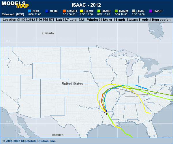
Models down the road I worry on and again.. people look at models these days and rely on a graphic like the one below more than they do the NHC and their cone.. a little knowledge can be a dangerous thing!!
Oh...and there is talk of him slowing down in the North Gulf as a very, strong Hurricane.
Besos for now... Bobbi
posted by BobbiStorm @ 5:49 PM
![]()


0 Comments:
Post a Comment
<< Home