A writer and a tropical muse. A funky Lubavitcher who enjoys watching the weather, hurricanes, listening to music while enjoying life with a sense of humor and trying to make sense of it all!
Wednesday, October 09, 2024
Noon Hurricane Milton 145 MPH Winds. NE at 17 MPH Headed Towards Landfall in W FL - Tornadoes Everywhere Across Florida Milton's Last Surprise ..Then Storm Surge and Landfall. Stay Tuned...
Close up of Cone at 11
St. Pete and Tampa
down to Port Charlotte.
Clearwater and Cape Coral beware!
Anywhere inside this cone can get the eye.
Not just the line.
Line is a measurement to see how much it moved.
Impacts outside the Cone.
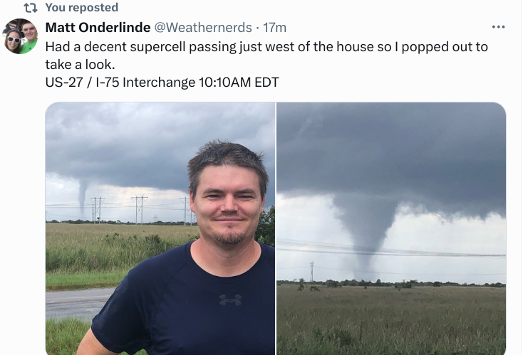
See the tornado below.
Milton's Nasty Surprise for FL outside the Cone.
And........in the Cone as well.
Day of Tornadoes.
Explanation on WHY Twisters above.
I told a friend online... "not really sure what else I can say today" and that's the truth as I think I've said it all having been concerned on people in the path of a huge Major Hurricane that will carry with it literally a dome of water known as Storm Surge into every bay, creek, cove, river and cute little canal where subdivisions were built to enjoy the beautiful Florida lifestyle and look out on the Gulf of Mexico or nearby marsh with awesome sunrise and sunsets but..... yes Hurricanes happen in the tropics.
Milton has been one long run on disaster in the process of unfolding as it finds new ways to surprise us with multiple RI episodes going fast from Cat 1 to Cat 5 and then he did it again! He dawdled a bit too long down near the Yucatan moving slower than expected and yet finally made the turn and then did rapid intensification again. A strange blob of rain has been riding out in front of Milton soaking, saturating the ground in Florida from Miami to Tampa to Jax way before rains from Milton will arrive and dump more rain causing more Flash Flooding as well as storm surge on top of rain that already fell. Gee doesn't that sound like the set up in Asheville when they got heavy rains before Helene that caused flooding from the French Broad River that was above flood stage and then as that system helped pick up and lift Helene North away from a direct hit on Tallahassee zooming up to the mountains of NC causing historic flooding and trashing parts of Georgia and South Carolina on her way to North Carolina. It was a 1-2 hit that made the flooding that much worse and now here we go again with Milton moving into an area that's had so much rain that my friend in Florida sent me a video of the grass swishing swashing with water below the top of the blades of grass.
Speaking of grass... The Everglades are literally known as "The River of Grass" and they covered a wider area than they do now and yet that area now is covered with cute lakes and canals in often gated communities out in West Broward but it is still low land and can flood fast. If you have shopped at a shopping strip out there this week you know it's been one big lake you have to navigate through to get to Publix.
Now, Milton has a new weapon in his arsenal to cause more danger and destruction as he's become a huge tornado producer and it's only 10:35 AM as I type this and I cannot keep up with the nonstop rolling feed on X of Tornado Warnings with various pictures of tornadoes along side the Interstate where cars are driving along thinking they must be in a movie but no ... it's Just Milton... "Impacts outside the Cone" that the NHC always warns of but everyone still watches "the Cone" ignoring the black line at the top of the Cone warning of impacts outside the Cone. TWC having a problem trying to keep up with Tornado Warnings and covering Milton's approach at the same time... they are trying. X feed looks like images from the movie Twister but in Florida not Oklahoma!
See black line? Believe it!
Radar....
every little red cell over SFL ...
...has tornado warned storms.
Cape Coral had tornado warnings.
Miccosukee Service Plaza below..
Milton swirling towards land in motion.
Notice in the loop how it's growing in size.
Width, Windfield expands as NHC said.
another look up close...
Doing that thing they do when the front grabs them.
They go WIDE
Windfield impact FAR from EYE
Size matters Wind Wise.
Larger area more injuries or death.
Hopefully not but Milton already deadly.
Storm Surge stays Cat 5 no matter.
A Cat 5 battering ram of Storm Surge.
On beaches, up rivers, into covers.
Rainfall leads to flooding.
Milton a mess of misery.
Chasers get an extra bonus...
...so much going on.
In closing.
What more can I say today?
1. Major Hurricane Milton on landfall, Windfield expanding as NHC forecast it would.
2. Storm Surge on it's way, no way to stop the storm surge even if winds continue to weaken.
3. You either evacuated if you were told to or you didn't, stay safe, prayers... send pics!
4. Hopefully if you evacuated you will have a home to come home to...
5. Tornadoes are literally everywhere and not talking "waterspouts" but Supercell Tornadoes.
6. Who knew Milton would deliver the Day of Tornadoes across Florida?
7. Inland impacts far from landfall, please "hunker down" stay in "safest part of house"
8. Milton speeding up as forecast.
9. Landfall Zone shifted South of Tampa probably but not for sure yet...Sarasota to Venice?
Models shown below tho where Milton actually makes landfall no one knows. Follow chasers such as @icyclone they are better than NHC For heads up on "landfall" as they converge to intercept Milton's core, his eye...
Models
Converging S of Tampa
Though a hit to the South...
...still hurts Tampa Bay.
Where ever landfall is..
..devastating flooding.
Bottom Line:
As I said in previous blog posts you can read "you gotta do what you gotta do" that means evacuate, hunker down and find safest place in your home to ride out Milton and that means least windows, maybe a bathroom.. most interior room. Keep your supplies near you, especially first aid. Crayons for kids. Keep phones fully changed, stay off of them ...text don't talk......speaking of conserving things stay home and don't waste gas. Battery powered radios or crank radios will be your lifeline to the world if you lose power and trust me many will lose power and the infrastructure is already stressed from Helene not Milton.
Storm Surge... can't go there as I have said it over and over. Your home could be cut off because some small bridge into your neighborhood over a canal or river floods or worse......you can be stranded from 911 services in the way a home in East NC was cut off during the violent No Name Storm with a warm core, 70 MPH winds and 20 inches of rain and the fire truck got there but the road was washed out and they had to watch the house burn down from a distance... heartbreaking for the family who did get out and their friends and fireman who wanted to help but could not as the road into the area washed out.
Stay safe. Be Wise. Stay home. Stay informed.
Watch out for Supercell Tornadoes ... and Storm Surge and things that go bump in the night from the wind.
Leaving a video here instead of a song below ... Mike from Mike's Weather Page talking on his regular broadcast Morning Brew before he gets busy with Milton and yes he will be chasing and yes he sent his wife and daughters to Tallahassee to be far from Milton.
Prayers for everyone in Florida today...
BobbiStorm
@bobbistorm on Twitter and Instagram
Twitter mostly weather and Insta whatever...
Pround to be up there on top.
Mike loves Florida and especially loves that part of Tampa where he lives in a suburb called Oldsmar. Why is that important someone asked online? Because everyone there lives in some little community they love across Florida... around Tampa Bay and down towards Sarasota and there's a heavy realization today that depending on Milton's final track towards landfall with it's associated strong hurricane winds, storm surge, flooding, tornadoes and severe weather in bands as it moves across Florida......Milton will take someone's paradise away, their beautiful home near the water where they love to sit in the late afternoon waiting to watch the sunset. You can hear the tone in his voice and there's a poignant tone. He really doesn't "love" hurricanes as some storm chasers do in their way he grew up watching, worried and made a site to help others stay informed on the storm. He messaged me one day years ago saying "putting your blog on my webpage" I said thinking "ummm" "Okay, thank you" and that was in the early days as I cannot, will not tell you how far back I've known Mike but we both started our sites in 2004, oh what a year that was... Never heard him sound this way ....as he did today. Maybe during IRMA but no quieter and focused and thanking people and asking them to stay safe.
Prayers and hopes as well and thanks for being here.
Location: Miami, Raleigh, Crown Heights, Florida, United States
Weather Historian. Studied meteorology and geography at FIU. Been quoted in Wall Street Journal, Washington Post & everywhere else... Lecturer, stormchaser, writer, dancer. If it's tropical it's topical ... covering the weather & musing on life. Follow me on Twitter @ https://twitter.com/#!/BobbiStorm


.gif)


0 Comments:
Post a Comment
<< Home