Busy Tropics. Hilary in the EPAC - 2 Invests in Atlantic - GOM 30% Yellow Circle. Big Day in the Tropics Tho News is All About Hilary Today & Possible Problems in California
I'm trying to keep this simple this morning.
A lot to say and more to say later.
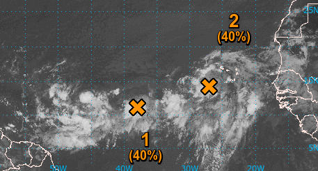
40% chances in the 2 day.
60% in the 7 day.
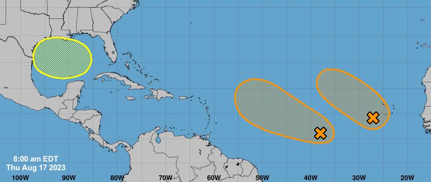
Areas where they would form.
Not a Cone... but formation zones.
30% Yellow Circle in the GOM.
Below on Zoom Earth you can see SAL.
Lots of SAL all the way near the Bahamas.
Invest 98L closer to Africa.
Lead wave Invest 99L
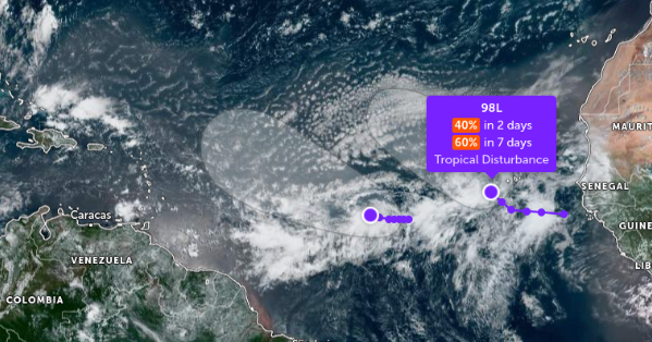
The view on Zoom Earth shows the Saharan Dust AKA SAL in the Atlantic. The dust suppresses development and usually as we move into September SAL looses it's grip on the Atlantic. We are still waiting to see that happen and it'll be curious to see how well the models do with these two Invests.
What 99L could do is more compelling currently than 98L as 99L has the potential for trouble down the line. Much depends on how it handles the SAL (if it stays weak it goes more to the West) and how good of a core there is IF and when it develops, and it is expected to develop. So for now, all eyes on Invest 99L.

Invest 98L, closer to Africa, is forecast to move up to the NW at some point, the question is how long does it continue to go NW and is there a chance for it to curve more to the West again. And, when you have a crowded field of contestants in the Atlantic that close it's worth remembering one can have an influence on the other. More on that later. They have to form a solid center and from there the models should be more spot on vs scattered about.

NHC upped it to 30% from 20%
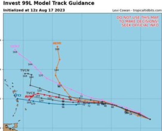
Models do almost everything on the block.
Just too soon to tell.
But telling you there is potential for a problem.

Note the wave nearing the Bahamas.
The dangling dead cold front in the Bahamas.
Generally it's thought this energy goes West.
Where exactly does it come together?
Location is everything in weather and Real Estate.

This shows the Heat Wave...
..this
could be a drought buster.
Or it could rain, rain, rain on Florida.

We'll talk about Hilary out West later in the blog.
Looking below at a MIMIC Image.
You can see how the moisture can come together.
A surger of moisture from 99L could help.
Should it stay weak and go more to the Wetst.
All just the dangling cold front dead in the water..
..often helps spark tropical development.

In August this is the set up.
Pretty much storms go anywhich way they want.

I'll update later today. I want to look at the next few model runs (they all run at different times) and how the lead wave does as how that does is important with regard to questions down the tropical road closer in. The problem with SAL is that it inhibits extreme intensification and while we could get a Tropical Storm it puts the brakes on wild development. The waves themselves juice up the moisture starved atmosphere and help later waves coming off of Africa to have a friendlier, juicier environment. If anything gets into the Gulf of Mexico it could be a huge problem as the water temperature there is extremely hot and untouched energy waiting for a well developed system to get into that hot water makes it a danger zone, things can spin up fast and furious and I'm not just quoting movie titles.

This area has less SAL.
This area has HOT WATER.
This area can support development.
If a well developed closed core develops.
Watch Out!!
As for Hilary....that's a big system.

Cone

Any rain of can cause flooding where it's going.
IF it hangs together and models say it will...
...the moisture signature is huge.
Even just the remnants can cause trouble!

Let's look at the rain graphic again.

In South Florida a rainy day is just another day in the summer. Local hotel owners tell the guests "we call it liquid sunshine" yet even a fraction of the amount of rain Miami gets on a typical day can make the Los Angeles River a raging flood, so while it may not look that dangerous even a little consistent rain in Sunny California where it never rains ......can bring flooding and a whole lot of trouble. It doesn't need to be a named storm as much as the remnants of Hilary to wash homes down hillsides and create torrential rainfall outcomes and real misery.

It's the Weather News Storm of the Day.

Still far away.... more to say on this later.
Thanks for your patience.
Woke up with a migraine so ... went slow this morning.
Feeling better now!
Sweet Tropical Dreams,
BobbiStorm
@bobbistorm on Twitter, Instagram and Threads.
Loved this song when I lived in LA....
...tho for cryptic reasons I won't disclose.
Listened to this song for hours, days, weeks in LA.
posted by BobbiStorm @ 9:15 AM
![]()


0 Comments:
Post a Comment
<< Home