Tuesday 8 PM Update. GOM Yellow Circle Added by NHC Along With 2 Yellow Circles in MDR!! Does NHC Put Another One Closer to Yucatan/Carib/GOM? Sexy Smiling Tropical Waves By Africa But Closer In Serious Questions. Will the GOM Wake Up? Is the Caribbean Closed?

NHC put a yellow circle in the GOM
20% in the 7 Day.
Several models have been persistent with something trying to form there and most likely heading West towards Tex/Mex but it's way too soon to buy a track for a system that has not yet developed. 20% in the 7 Day and well we are watching. Glad they did that as storms in the GOM can ramp up fast and being so close in there is often less time to respond.
In my world there was crazy weather in Raleigh today, strong winds and intense storms. Anytime you have a front moving down into an area with excessive heat you know you have the potential for severe storms and that potential was indeed realized today. Trees down, power outages and an overall mess with a 32 car pile up in the middle of the storm in Durham. Showing the picture below. Kat Campbell does a great job explaining weather in Raleigh on WRAL, really the only weather person I follow on WRAL!

We will talk on models tomorrow re: GOM
And for the 2 waves in the Atlantic!

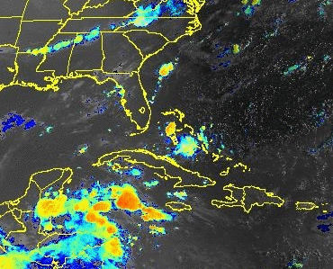
Lastly.... heavy storms over SFL today.
Fronts on the move.
Yucatan/Cuba moisture.
Something is changing.

Check back tomorrow morning!
* * *
8 AM
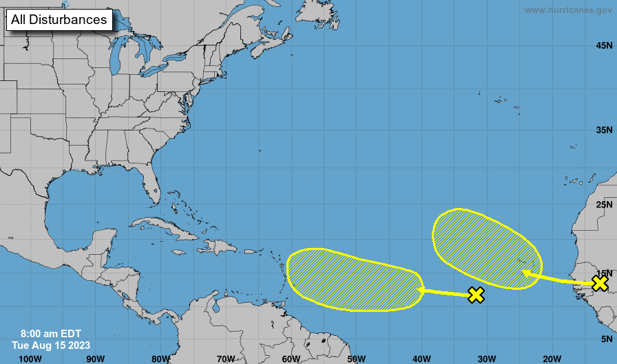
left wave 10% in 7 days.
right wave 30% in 7 days.
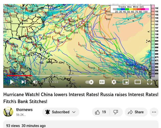
If you read yesterday's long blog you'll understand this pretty much says it all. Ensemble models will offer you pretty much anything you wanted to see as the Thor shows here the maps are covered with scribble scrabble tracks kriss krossing the Atlantic Basin.
We are in Prime Time as far as the Hurricane Season as it's August 15th! From here on in we are working our way towards September, towards Labor Day and towards the time when tropical waves could turn into wicked hurricanes. And, long dangling fronts decaying across South Carolina then stalled out near the Gulfstream can spark tropical development.
See the real issue here for today is you gotta have a LOW. Yes, IF convection stays over an area of warm water, with low shear and less SAL (Saharan Dust) then maybe something will start to spin. But, if you have a spinner to begin with it's a whole different ballgame. Bottom line becomes "play ball" and the games begin. For chasers that means they begin to hone their game plans (always good to have options) and for those who are terrified of a hurricane after going through a direct hit of a Major Hurricane they are ready to roll, grab what supplies they need and plan a trip out of town somewhere where the hurricane isn't interested in going. For those who like to hunker down and refuse to leave town, this is prime Prepper Season, again serious hurricane trackers are at heart Preppers always considering worst case scenario. Which one are you? Who you are and why you are here dictates everything.
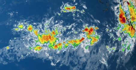
We have a more vibrant moist ITCZ
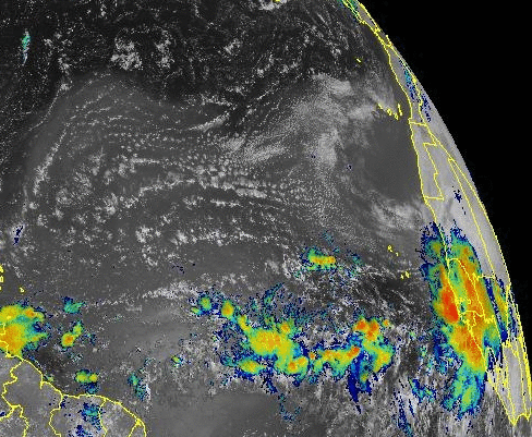
Close up let's look at our newest wave.
The wave is smiling.
Ready to roll.....
...let's see what it looks like in 2 days.
I've been friends with Jim a long time.
I don't like to admit knowing someone that long.
He's good, he's usually cautious & conservative.
Conservative on not hyping tropical waves.....
....with this much SAL on the maps.
So bottom line here is the following questions.
Did El Nino shut down development in the Carib?
Is El Nino an Influencer or a pretender?
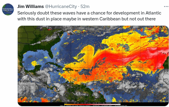
SAL is holding court in the Main Development Region.
You can see in the image above the waves are suppressed to the South under the SAL.
Fronts can often be players, kingmakers in the tropics as storms can form at their tail.
IF SAL shuts down development far out... and the Carib is closed. (lots of IFS)
Do hurricanes form closer in just past the SAL or in the more protected waters of the Gulf of Mexico?
With a plethora of possible tracks on the Ensembles, where is it most likely to see tropical development.
When I say Tropical Development I mean getting a Name not a Yellow or Orange circle or Invest.
SAL VS New Wave in MDR
Long shot to watch...
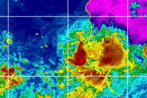
Wave down S of Cuba near the Yucatan.
Trying to sneak into the GOM?
Note the blue curved front across the South.
Always watch sneaky waves down here.
Camille started down here....
...in an analog year.
Camille could not get it going before here.
Then nothing stopped Camille.
Lessons learned from history.
(models not showing much but...
..models change often)
Listening to Mike talk, kind of, looking over when he says "Blobby Bobbi" as oh my gosh we go way back too. Love being able to listen to my friend's thoughts and then going with my gut and what makes the most sense to me based on knowing Hurricane History, Climo and the current conditions in the Tropics. I find more info in the Water Vapor Loop than every changing models.
.gif)
Bottom Line.
While the new wave is all sexy and smiling.
I'm watching the convection near the Yucatan.
Watching to see if something tries to form, if something forms and remembering what happens later was the next weak wave that could not form in the MDR due to SAL gets into the exact same spot in a week or so. This is a pattern. Weak waves move West, like the one that was an Invest and couldn't make the grade in the Caribbean but as Hurricane Dora in the EPAC it contributed to one of the worst natural disasters in recent history in Hawaii. Weak waves go West, stronger waves try to come up over the Islands (above them sometimes) and then it's all about the High. The oldest story in Tropical Weather History.
Stay tuned. I'll update later IF the NHC puts a yellow circle in the Caribbean or goes orange on one of our tropical waves in the tropical wave parade.
Have a great day, whatever it takes to float your boat have a great day!
Besos BobbiStorm
@bobbistorm on Twitter and Instgram... and Threads (follow me there, say hi to catch my attn)
posted by BobbiStorm @ 7:26 AM
![]()


0 Comments:
Post a Comment
<< Home