Late Night Update ... Where are those waves going???? Multi Colored Circles in the Atlantic. Red, Orange, Yellow...Which One Goes the Distance? Nana Made Landfall as a Hurricane and is Gone Like OMAR. PAULETTE NEXT NAME UP TO BAT!

The grid from Spaghetti Models.
Note the new yellow in the N Atlantic.
Red and 2 Orange circles now in the E Atlantic.
Are we busy enough yet?
I've said I'd talk models later today and it's tonight so it's late and yet really there isn't anything hard data wise to say other than models keep trying to juggle the movement of the 3 out by Africa and make guesses on the strength of the High, how high is it really and will it be a stronger high in the near future... many models show a very strong high. Some models show a wave slipping away to the North sooner rather than later yet other models show it continuing West at a higher latitude as the High snaps back. Models often have problems handling two systems yet when there are three they get that much weaker at resolving the reality of the future movement. In truth it everything reacts in real time as one fights for domination or if one has a better structure, for now they are out there. The enviroment is very moist and the water is very warm, especially in the area between Florida and the Virgin Islands as no large systems have been there and there is no upwelling, it's just how, welcoming and ready for action.
I did a few models for you on www.windy.com note I prefer to show the rain and thunder filter because then we see how much convection there might be aside from winds.

This is the Euro, 4 systems traveling in unison.
Again you can change filters on the website.
The GFS is below.

The GFS shows trouble as well.
Less closed systems on this run.
Lots of contenders.
That wave yet to come off Africa looks good.
But that's a week away.
Something North of the Islands ...
Hard to figure, messy models.

I'm showing the NAM just because.....
...it shows a Tex Mex system or heavy rain.
It also is a good way of reminding you...
..it has a limited target area.
Close in...
Nothing out there.
But things do pop up this year.
So models are only as good as real time verificaiton.
Sweet Tropical Dreams.
Keep reading if you didn't do so...
Will see what colors we have tomorrow.
Perhaps an Invest in the morning in the Atlantic.
* * *
Updating the blog with 2PM #tropical update on colorful circles & waves off of #Africa westbound & why ppl are worried on long range models... Y=High pic.twitter.com/aCKZvSt2Om— BobbiStorm (@BobbiStorm) September 3, 2020
2 PM Update on our Colorful Circles.

Red jelly bean still 70%
So what's with the models?
I'll update with specifics later today.
But Ed does this best and he's good.
European model is picking up on four areas of decent low-level spin in the tropical Atlantic over the next 7 days. Very uncertain which ones develop or where they go. It does signal an ocean & atmosphere more conducive for tropical development over the next few weeks #scwx #ncwx pic.twitter.com/WGoRpRltF7— Ed Piotrowski (@EdPiotrowski) September 3, 2020
Note what he said.
It signals a more conducive atmosphere...
...for tropical waves coming off of Africa.
And possible tropical development over the next few weeks.
His words.. not this week or in five days.
Why?
Because as I mention in the blog below..
.. we are moving into the heart of the season.
So now is the time to pay attention.
NHC NWS and people online you trust.
Trust is earned I'll add.
Make sure your hurricane plans are ready to put into action.
Because you may have to put them into action if..
..that high holds in place as it is forecast to do so.
More specifics later but this is the gist of the problem.
Peak of Hurricane Season coming...
..and viable waves are showing up on time.

8 AM graphics below.

Let's play the NHC Peek A Boo Game.
1st Page is the 2 Day.
"wow there's two waves off Africa you think..."
Nana made landfall.
Waving bye bye to Nana and Omar.
Then you go to the 5 day.

And most of you say some sort of curse phrase.
Or you roll your eyes.
Or you start shopping for hurricane supplies.
Because it's SEPTEMBER going into the...
...Heart of the Hurricane Season.
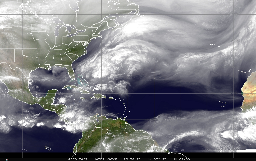
Here's the wide satellite.
We see the Wave Trio far to the right.
Frontal boundaries draped across the image.
A dark high to the North of the Wave Trio
And a very MOIST Caribbean.
That's a bad set up.
And it will get worse if the High gets stronger.
Why? Because the waves stay suppressed moving West bound, finding moisture (fuel) for development and then they look for a low to move towards and in this case that means frontal boundaries. The models are dipping down begging them to follow so this time of year it's all about location (like real estate) if you get a wave developing into a hurricane in the right location it will either zoom off towards landfall while developing or move out to sea with the front. More on this later but wanted to explain this early on because we truly are deep in the heart of the Hurricane Season now when dangerious long tracking hurricanes can and will form.
THIS PARAGRAPH IS FOR MIKE and others reading this today.
And when I say the "HEART" of the Hurricane Season I really mean that most people who have been through Hurricanes figure their heart is gonna be broken, along with their screen patio and their umbrella tree will take flight like Mary Poppins and they pray the roof stays on protecting their home. Yes, a busy hurricane season can be a real heartbreaker and then you clean up, or sell what's left of it hope your insurance pays you and move away from hurricane country to Wyoming thinking snow ain't that bad or you rebuild and come the next hurricane season you are on Mike's Weather Page listening to and hanging on to every word he says while trying to read comments that scroll by faster than a hurricane wind. Even when it's slow in the tropics and no one is in the cone, Mike's friends are chit chatting away enjoying Mike's keen insight and folksy stories. He gives good advice, good thoughts (while always reminding people to follow the advice of the NHC) and you learn a lot by reading the questions and thoughts of the people who follow him. Because trust me once you have had your heart broke by Charlie or Katrina or Irma if you are still living in hurricane country you crave as much information early on those orange, yellow and red colored circles in the East Atlantic in the first week of September. Mike's song is at the far bottom of the blog, the second song.
So what can I tell you? I can tell you two things. The first is look at the actual satelitte images of the tropics and check out what long range fantasies the models are cooking up and then check back tomorrow and tomorrow because luckily we are at the "tomorrow" range with these waves. I can promise you one will fade away, one will struggle and one could possibly be the real thing that gets a name that is retired and remembered forever. And if not one of these three, one of the next few coming off. It's that time of year. I call it Captain Climo time and that's because Climatology aka CLIMO is King this time of year and it will beat MJO discussion or Kelvin Wave talk and it rules it September going into October. One way or the other we have a problem down the tropical road as the HIGH is building back in and now that Cold Fronts are being predicted like the results of an election somethings gotta give. And may I remind you polls like models can be wrong, but we follow them just the same but far out keep it for entertainement purposes .. but if it gets you shopping for supplies or figuring out where you will evacuate to if you have to ...then that's good too.
I will show models this afternoon after the next model runs. Will the cold front dipping down into the country still show up? Again that matters. If a wave gets far enough West it will ride the cold front begging the storm to follow me we can travel the world and see places together. IF the cold front dips down and the wave becomes a hurricane and it's far to the ESE it will most likely sweep up the Cold Front and sweep it out to sea and everyone will say "see I told you it would curve away" and if the front pushes down far enough to pull the hurricane WNW or NW towards landfall on Florida or the SE Coast and then it fizzles out with lots of low pressure hanging around say Charleston or North Carolina and the High builds in you end up with a dangerous situation because playing a game of chicken with cold fronts early in September often ends up bringing hurricanes onshore rather than being swept out to sea. So which will it be in say 10 days time? Can't say right now, but keep watching... keep listening to Mike and others and keep reading my blog I'll do the best I can to give you information; in reality that is what most of us are trying to do because we know what it's like to live in hurricane country and know you can't always get lucky and watch them curve out to sea even if you wish they would.
Second thing I want to remind you is to go to your local authorities. Mike has many good links on his page and just under my name (so proud to be there really, it's such an awesome site) is a place for you to get your local weather. While watching models for ten days down the road or staring at your favorite loop with a far away tropical wave, remember you can pay attention to your local weather on Mike's Weather Page aka Spaghetti Models also!

Did you ever notice that on his page?
Type in your zipcode.
It will take you to your NWS page.

I have a heat alert.
As in stay inside if you can't take the heat.
I'm staying inside ;)
With weather think local first.
Global next.
Often I miss a tstorm warning here............
....because I'm staring at a loop showing me Africa.
True Confessions.
I bet if you are reading my blog that happens to you too!
Raleigh and getting remarried kind of set me free from that cycle of craziness but good memories as my kids were going out into the world and they encouraged me to move to Raleigh and marry my husband (I think they really wanted to get rid of me lol) and we talk on FaceTime and online all the time but I do miss them and my Miami friends, but Carolina has become home in many ways. I now know what those places I always heard about such as Morehead City or Wilmington really look like and I know the wind feels like when you are at the Outer Banks and I'm obviously still in hurricane country but I also get the seasons and the chance of Carolina Snow. And, while doing other stuff I have time to research and write on history both hurricane and otherwise.
So I'll be back later with an update. Watch the loop below and remember those 3 threatening circles far out in the ocean are a very long way from an upgrade to named storms and some will stay South, some may recurve and some may fade away as the stronger one takes over sucking up all the energy in the atmosphere. Probaby a lot like friends you have in club or job somewhere as that's the way of the world.

Great loop.
I call it the HIRES ...
Like Root Beer ya know..
..goes good with ice cream!
Seriously allows you to watch the whole basin!
Have a beautiful day! Stay out of the sun and stay well hydrated if you have to be out in the hot sun and keep preparing for the Hurricane Season, watch the models but don't buy into early runs before they have formed and keep listening to Mike ... and me... and others you enjoy who you have come to rely on for good advice and always watch the updates from the Hurricane Center.
This is the link to their daily discussion. Many of us read every word carefully, while many newbies watch models that come and go unreliably. The words the NHC uses to describe the many waves and tropical bumps in the atmosphere give you clues as to what they are really thinking when they color an circle with a yellor, orange or red crayon!
Stay tuned, check back later and have a great day.
Besos BobbiStorm
@bobbistorm on Twitter and Instagram
Ps I'm still trying to get the Jambalaya song out of my head. I went to Instagram to a friend's cooking site and I'm guessing she is reading my mind as she showed how to make a fast Jambalaya and when I say fast I'm reminding you to watch for things close in to pop up while you are staring at African Waves!
and a song for Mike .... I hope we all get lucky this year and they all recurve out to sea and we can enjoy a beautiful sunset on a boat or out by the Low Country in the marsh where the sky turns shades of coral and sunset gold.
posted by BobbiStorm @ 8:16 AM
![]()


0 Comments:
Post a Comment
<< Home