2020 Hurricane Season... Where We Are Mid August. A Bevy of Named Storms Yet Still Waiting for MJO and Capt. Climo & the Real Hurricanes to Show Up. Areas That Could Be Impacted? Where's Superman When You Need Him?
As of 2 AM Monday Morning.

Mid August.... will the Atlantic come alive?
If you were looking for Cones you don't know me ;)
Cone haven't changed.
But there are subtle weather changes going on...
...that will impact our Season that need discussing.

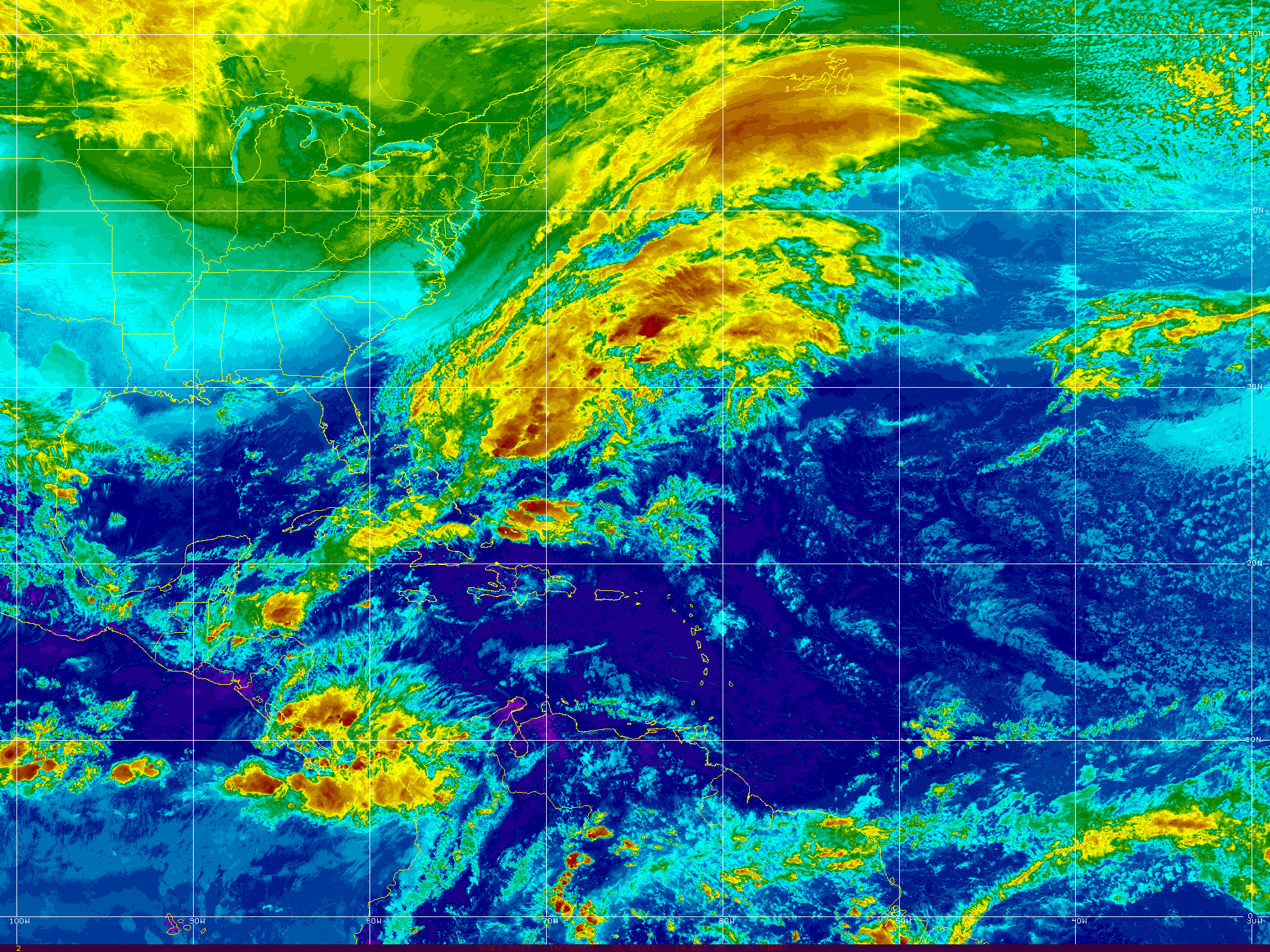
What I want to call your attention to is the fronts.
Moving in from the NW...
Pushing down across the middle of the country.
Sliding down into the SE
Reinforcing front behind the lead front.
The reality is that the real Hurricane Season when we have real hurricanes and real worries is when fronts begin to start rolling and African Waves roll off of Africa at a higher latitude than previous waves and the atmosphere begins to do this wild dance where systems collide and strong hurricanes have lows along frontal boundaries to race towards and sometimes hook up with the front as traveling partner as they swoop off to sea recurving away form landfall. At other times, the front beckones the hurricane in and other factors happen and the hurricane catches the front as it makes landfall moving up into the country bringing heavy tropical rain and sometimes flooding rain and severe weather. That switch is beginning to flip currently so watch carefully over the next week for more changes to occur along the way.

Check out the grid above from www.spaghettimodels.com
Northern systems are moving East.
Southern systems are moving West.
Josephine wobbles WNW
Now moving WNW at 14 MPH

Recon finds Josephine barely a tropical storm.
It still has the same signature on Earthnull.
It's looked like this for a while.
Egg shaped circulation.
Strong convection.

At least you can find it on satellite imagery.
Kyle is an elongated low embeded in a front.

Honestly Josephine doesn't look that bad.
Looks the way it's looked.
Imagine had recon gone in earlier...
...they've have found that days ago.
It's a weak but persistent tropical storm.
Try and pick out Kyle to it's North?
A weak area of spin in the Atlantic is being watched.
The African Wave rolling off is impressive.
So where do we go from here?

Everyone onlike seems to be waiting on the MJO.
Spoiler alert the MJO didn't do much in the EPAC
Yeah lots of colored fruity circles with expectations.

This is not a bumper crop of hurricanes or storms.
By mid August they should have had more.
MJO uppted the possibiliites.
But few have achieved any greatness.
MJO discussion always reminds me of little kids asking "are we here yet" or "when is Uncle Charley coming already?" if you ever had kids and hey we all love our kids but they can be a little whiny... when they are impatient because we aren't there yet and or the cousin they were waiting to meet at the playground still hasn't shown up.
Jim Williams, www.hurricanecity.com is not a huge MJO fan and he's the type who marches to his own drum and does his thing and by the way he does it very well. Most love to talk on the MJO but remember it's a forecasted event much like wind shear and changes in ocean temperatures. Climo shows up when it's ready and usually it owns the whole band and when it plays loud it's one huge marching band you can't ignore.
MY thoughts?
Sometime later this week we may see signs of changes both close in (more down in the Caribbean or closer to GOM) of changes and around the 23rd (give or take a few days) you will see real probabilities to talk on and I find it hard to believe with this current set up that as Labor Day weekend approaches we won't be dealing with a real hurricane threat. Where? Could be anywhere. It could be from a tropical wave that made it across the Atlantic scaring people in the Islands first then South Florida on alert and watching or it could travel into the Gulf of Mexico. Much depends on where the fronts and the HIGH pressure is set up when that happens. This last week the High was missing in action a bit and the whole area near Florida and the Caribbean was kind of chaotic. If the high builds in to the North and low pressure forms to the South and if a front dips down the way they are dipping down tonight then an opening would occur to allow the possible hurricane to move towards landfall along the Gulf of Mexico. Another possibility would be a Isaias sort of system that tracks up and is drawn in with a weakness but more concerned on the East Coast later towards October. Though the way this season is going if things continue October may happen in late September. I have some real issues with forecasts for Fall and Winter but that's for another day.
We ain't got no El Nino today. We aren't yet in La Nina territory yet we are flirting with it and here we are in Neutral going into a La Nina that can bring dangerous late season hurricanes and a very messy Winter.
So stay tuned. I'd expect the NHC to give the wave of off of Africa a yellow rose or an orange carrot soon but time will tell. As for the yellow circle in the Atlantic now keep watching. As for Josephine, she probably will run out of steam but she's been sneakily consistent so far and either she opens up into an open wave or as a tropical wave she delivers tropical moisture to some place as she wanders along more in line with low level wind flow. Not talking on Kyle.
So get ready because whether the MJO shows up or whether it doesn't deliver the punch that was expected Captain Climo will show up and waves will be rolling and fronts will be dipping and the High will try to hold on but the real answer to this tropical mystery will be blowing in the wind.
Later today (it's 1 AM Sunday Morning) I'll do a bit of Hurricane History with Hurricane Andrew and perhaps another hurricane because I want you to remember how fast your beautiful landscape can be rearranged by a hurricane and in Andrew's case a storm they wanted to pull the plug on because it looked crappy but they waited and that was a good move as it was then that Andrew made it's move and turned directions suddenly and rapidly intensified. Camille came together in the Caribbean from a struggling tropical wave and Florence counted out as a Fish and nothing to worry about became something to worry about.
Regarding Jim Williams he puts a lot of time into his seasonal forecasts where he pin points cities that should be impacted in the huricane season. He doesn't update them 3 or 4 times a year he spends months studying, evaluating and then puts out a forecast.

The yellow highlighted cities have all been impacted.
We are talking this year......
That leaves a few places left.
Big cities being
Miami, Tampa and Galveston.
If you throw in some low rider sort of system that goes through the Caribbean, impacts the ABC islands Jamaica and Cuba near the Yucatan Passage and gets into the Gulf of Mexico and heads towards Galveston, well he'd hit most of those other cities with one Caribbean Cruiser into the GOM. There are some that argue his methods yet in the end his results often are totally on the money. So think on that a bit.
Sweet Tropical Dreams,
Besos BobbiStorm
@bobbistorm on Twitter and Instagram.
Ps..
If ever a year needed a super hero...
...it would definitely be 2020.
Ps.....Smallville has beautiful sunflowers this time of year.
posted by BobbiStorm @ 10:04 PM
![]()


0 Comments:
Post a Comment
<< Home