Hurricane Matthew Heading West Expected to Pull North Over Cuba.. Haiti? Gulfstream Jet Going In To Sample Atmosphere Ahead of Matthew. Models Take Aim...
That closed red symbol means HURRICANE.
Hurricane Matthew pulling it together in the Caribbean.
Personally in the short term I think Matthew will take the Left side of that cone.
Long term it most likely will slide along the Florida Coast to the right.
At some point it can come closer than many would like to see.
But it's probable it stays off shore... or we hope.
Map from NRL .. NAVY Site
Has more details as you can see.
Wide View
Note moisture to the NNW of Hurricane Matthew.
Note strong high to it's NE pushing it West
Note new wave coming off of Africa. Low but there.
That's a lot of notes to put together a song.

Solid core, CDO
Hurricane Matthew
In motion

Again NHC forecasts a possible dip to WSW briefly.
Before pulling North.
I find those models unreliable on some levels.
GFS slams Matthew into East Coast.
I don't see what's there now to do that.
Then again it's all fluid and much can change.
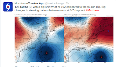
EURO keeps it out to sea.
Not talking all model ensembles just the average.
Watch the WV Loop

Now look at this area up close
North of the Bahamas there is an Upper Level Low forming.
I saw it last night beginning.
It's getting stronger.
IF that ULL gets stronger it will help steer Matthew.
That may be what the Euro is seeing.
Maybe.
IF the Euro moves more to the West..
The GFS moves more to the East.
I'll believe them a bit more.
This Tweet explains the differences.
Also from one of my favorite weather sources:
Another great image that explains the future.
Yesterday I showed this to a friend.
This graphic came from Tropical Tidbits.
He started off my drawing a line more to the right (E)
Then showed multiple possibilities.
I took a picture, used my non exploding Note.
Drew a line I felt was more logical in orange.
That line is not set in stone.
These were my thoughts last night.
This afternoon the models are coming around to it.
I'm not a computer programmer.
I'm not great at making online graphics.
I'm not a forecaster at the NHC.
I'm a writer.
I am very good at the Water Vapor Loop.
I had special training by the best!
(that's what she said)
What I am is a Hurricane Historian.
I know hurricane history as well as history in general.
Several big landfalls in recent years in NC ...
...came in years when it rained for days before the hurricane.
A weakness in the ridge set up and moisture is a magnet.
Not saying NC will get hit saying the lingering moisture worries me.
A friend in NC said this when I asked him on the flooding down his way
It's not all about the High and the Front.
It's about Upper Level Lows as well.
They are big game changers.
Don't look at the big spinning low in Midwest.
Look in Northern Bahamas

That ULL is just ramping up NE of the Bahamas.
How does Matthew turn so dramatically?
After dipping down like a tango dancer?
More than just the front creates the steering mechanism.
Watch that Upper Level Low and where it goes.
http://moe.met.fsu.edu/cgi-bin/ecmwf-opertc2.cgi?time=2016092912&field=Sea+Level+Pressure&hour=Animation
One model
That is just East of where Julia came ashore.
Sliding up ...

That's a sharp turn expected over Cuba.
Matthew may be a big hurricane for Cuba.
Possibly Cat 2... into Bahamas.
Or maybe closer to Miami ... Nassau.
Northern Keys could feel it's effect.
Maybe.
GFS comes in round NC beaches
Moves North like another storm this year.
Slame into NE MidAtlantic.
Been there before with this scenario
Busy season going huh ...
2016 above
Been here before and not going there yet.
Long range things change.
Loop it. Press Run
http://moe.met.fsu.edu/cgi-bin/navgemtc2.cgi?time=2016092912&field=Sea+Level+Pressure&hour=Animation
A viable solution more conservative than GFS.
"It should be noted that the NOAA G-IV aircraft is currently
doing a synoptic surveillance mission to provide data in the
environment of Matthew for initializing the numerical models.
It is hoped that these additional data will improve the
accuracy of tonight's model runs."
That's the big news of the day besides Matthew is now a Hurricane. We are waiting for better model solutions with better data in so we don't get garbage in and garbage out. So we will see what we will see tomorrow. Today is a day for Hurricane Matthew to spin in all it's glory.
I'll update later as things evolve. Today there is flooding in parts of the Sandhills. That's down South of Raleigh but not super close to the coast. That's how we speak round these parts. I'll be watching Miami Dolphins tonight and watching the models come in and discussing them with weather friends and maybe I will change my mind but for now Cuba is in the crosshairs. Haiti is not out of the game just yet. Stay tuned.
Long term? That's what we hope to learn from the Gulfstream Jet.
Besos BobbiStorm
@bobbistorm on Twitter in real time


0 Comments:
Post a Comment
<< Home