Atlanta.. It's the Pattern. History Repeating. Lessons in Patterns & What is a Wedge?

Atlanta:
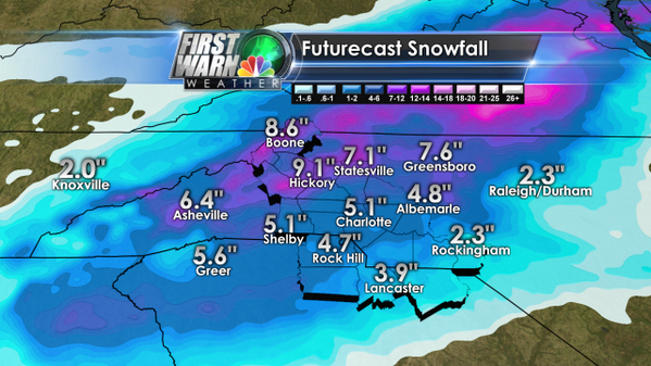
Big concern in Atlanta as in Raleigh as to where the "WEDGE" sets up ... meaning how much is snow and how much could be ice ...or both. Brad Panovich does a great job explaining this problem...
"Before we get started, for those asking, storm totals for ice and snow do not matter this week. This isn’t about pinpointing a snow total, but rather pinpointing how the weather will pose a threat to you.
With that said, nothing really is changing with the forecast with each new model run. The biggest impact will be the development of the “wedge”, or the shallow cold air moving down across the east coast by Wednesday. Based on the current timing, the moisture will arrive about the same time as the “wedge”, and that creates a high impact ice situation event for all of the Atlanta area to worry about."
read all about it here: http://loznickaland.com/?p=1628

WEDGE as posted by Brad on his page shown above..
https://www.facebook.com/wxbradWCNC
https://twitter.com/wxbrad
The point here is to remember it's all about the pattern this year and with CLIMO factored in and what is happening live on the rad..
Let's start with the definition of the word: "pattern"
"regular form; a regular or repetitive form, order or arrangement"
It seems almost to obvious to point out that we are caught in a pattern that will eventually end, but for now it's going to bring more winter misery to the parts of the South that were threatened two weeks ago with the same type of system. Atlanta is especially under the gun.. in the cross hairs... just generally feeling cursed.
We see this with tropical weather often. An easy example of how a stuck pattern brings a similar but different storm would be the visits of Frances and Jeanne to Florida in 2004.
Yes, it was a busy year. A strong Atlantic high steered storms far west towards Florida and all the various ports of call for Canes along the Atlantic Coast. If a tropical wave made it past 50W it was Florida or Bust.

Frances took a traditional Cape Verde sort of track up over the islands and into South Florida. What was interesting about Frances is that she hit the Florida coast a bit further to the north than most of those storms usually do. That said... it's called "the Treasure Coast" for a reason and many a Spanish Galleon was sent to a watery grave way before those 5 Avengers lost their way in the Bermuda Triangle.

Note if you smooth out the track of Jeanne below, take out that "off to see the world" loop she did you basically have the same exact track...
Note again... Jeanne made landfall on September 26th... about 3 weeks apart. That's a stuck weather pattern.

Jeanne is especially interesting as you have to remember to spell it that way without the "i" and it made a large cyclonic loop out in the Atlantic before resuming it's motion and following the path of Frances towards a part of the Florida coast that rarely gets direct hits. 2004 was a long messy hurricane season.. much like that sentence, but famous for being followed by an even longer season in 2005.
Patterns often repeat close together... yet there are differences. That can be seen in 2005 when both Katrina and Rita took a similar path, but with different end results. South Florida dealt with both before they moved to to their final ports of call and before Wilma finished us off..


Back to winter weather.
Atlanta is stuck in the pattern of being under the gun for another wintry mess and yet has the rare chance in one year to redeem itself by handling itself better this time around than last time... a mere two weeks ago. Note the date of Wednesday, January 29th, 2014 on the newspaper shown below.

What will this Wednesday's headline be after the Winter Storm Pax moves past Atlanta and on to Charlotte and Raleigh-Durham? Will Pax be kinder than Leon was? For anyone keeping track those are TWC names for these Winter Storms otherwise known as Misery and More Misery.
More interesting than the picture Cantore posted for where he thinks the snow will go is the comment he added on his tweet. Note "overachieving" is one of those code words weather people use when they don't want to say it's doing more than the forecast suggested. Sort of like when we say a hurricane is "wobbling a bit more to the left" rather than saying "it might come in further to the South than the projected landfall."
Jim Cantore @JimCantore now
That should provide spotty light snow for TN,AL,GA,NC,SC but mostly southern Appalachians even though its overachieving in MO w/2" already.

Everyone's talking... tweeting and posting their thoughts. Choose your favorite ... which hopefully is me!

Ironically there is a small chance that Raleigh could get some snow flakes today, normally everyone would be freaking but at this point everyone is worrying on Tuesday, Wednesday and Thursday.. go figure.
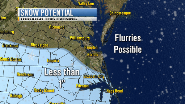
From the NWS Discussion... it's a murky forecast for Raleigh as no one is sure (including the NWS) what exactly will evolve on Tuesday and Wednesday.
"THERE IS INCREASING CONFIDENCE IN A WINTER STORM OVER CENTRAL NC
BETWEEN TUESDAY AFTERNOON/EVENING AND THURSDAY.  HOWEVER..THERE ARE
STILL MANY FORECAST ISSUES TO BE RESOLVED AND THE EVOLUTION OF
PRECIPITATION TYPE AND POTENTIAL ACCUMULATIONS REMAIN RATHER MURKY."
Goes on to say this ...note they are not in a rush to say exactly what type of P types we will get. P types meaning precipitation... freezing rain, snow..sleet or all of the above..
".THERE IS MODEST AGREEMENT THAT THEY WILL PHASE AND
AMPLIFY OVER THE SOUTHEAST US BY WEDNESDAY...LEADING TO CYCLOGENESIS
FROM THE GULF COAST TO THE CAROLINA COAST. THE LOW WILL THEN MOVE UP
THE COAST...WITH MIXED PTYPES OVER CENTRAL NC. THERE IS MEDIUM BUT
INCREASING CONFIDENCE IN THIS SCENARIO."
From the NWS I'm including the discussion to let you see just how MURKY it is... mind you my nose is cold and when they talk on the "nose" they mean the wedge... Understand in this case its all about the atmospheric layers which is why we call it ATMOSPHERIC SCIENCE.
"THERE IS LESS CONFIDENCE IN WHEN EXACTLY PRECIP WILL BEGIN...HOW
CLOSE TO THE COAST THE SURFACE LOW WILL TRACK AND HOW PRECIPITATION
TYPES WILL EVOLVE.  TO START OFF...MODELS HAVE BEEN RELATIVELY
CONSISTENT IN SHOWING A WEAK DISTURBANCE ALOFT AND A PERIOD OF WARM
ADVECTION ACROSS THE SOUTHERN CWA ON TUESDAY AFTERNOON...AND WITH
SUFFICIENTLY DEEP MOISTURE ICE NUCLEATION...WOULD LIKELY BE SNOW
BASED ON PARTIAL THICKNESSES.   FURTHER TO THE NORTH...CLOSER TO HWY
64... THE LIFT IS WEAKER AND THE LOW-LEVELS ARE DRIER IN THE CORE OF
THE SURFACE RIDGE...SO THERE IS LESS POTENTIAL FOR ACCUMULATING
SNOW.  ALSO...THE 850MB FRONT WILL BE SITTING JUST TO OUR
SOUTH...AND THUS A WARM NOSE COULD BE DRAWN NORTH BY THE WARM
ADVECTION AND CUT DOWN ON SNOW AMOUNTS WITH SLEET MIXING IN. AFTER
COORDINATING WITH WPC...WE FEEL AMOUNTS OVER 3 INCHES FROM THE FIRST
BAND OF SNOW MAY BE A WORST CASE SCENARIO...ESPECIALLY WITH THE WARM
NOSE ON OUR SOUTHERN DOORSTEP AND THE IMPLIED POTENTIAL FOR A MIX OF
PTYPES. THIS WOULD MORE LIKELY END UP BEING ADVISORY CRITERIA.

FOR TUESDAY NIGHT THROUGH THURSDAY. AS THE SURFACE LOW MOVES UP THE
COAST WEDNESDAY... MODELS SHOW INTENSE WARM ADVECTION DRAWING THE
WARM NOSE FURTHER NORTH AND WEST INTO THE PIEDMONT...BUT WHERE
EXACTLY A PTYPE CHANGE OVER WILL OCCUR WILL SENSITIVE TO THE TRACK
OF THE SURFACE LOW.  THE NAM AND ECMWF CURRENTLY SHOW A TRACK
HUGGING THE COAST AND ARE WARMER...WHILE THE GFS IS FURTHER OFFSHORE
AND COLDER OVERALL.  THESE DETAILS WILL INEVITABLY CHANGE IN
SUBSEQUENT MODEL RUNS AS WELL.  WHAT WE HOPEFULLY CAN GLEAM FROM THE
MODELS IS THAT THERE IS THERE IS THAT THIS SYSTEM SHOULD CAUSE A
MORE CLIMATOLOGICAL PTYPE DISTRIBUTION...VARYING FROM A BETTER
CHANCE OF SNOW AND ICE IN THE WEST AND A MORE PROBABLE CHANGE OVER
TO ICING AND/OR RAIN IN THE EAST.  HOWEVER...THIS DOES HAVE THE
POTENTIAL TO BE A SIGNIFICANT WINTER STORM BASED ON PERFECT PROG OF
POSSIBLE SNOW AND ICE AMOUNTS.

FROM ALL OF THIS...WE PLAN TO ISSUE A WINTER STORM WATCH STARTING AT
NOON ON TUESDAY FOR COUNTIES SOUTH OF HWY 64...WHICH WILL ALLOW US
TO HIGHLIGHT THE POTENTIAL FOR ACCUMULATING SNOW ON TUESDAY.  THE
CUTOFF IN SNOW SHOULD BE SHARP AND CONFIDENCE IS TOO LOW TO ISSUE A
WATCH FURTHER NORTH. THE INITIAL WATCH WILL BE GO THROUGH THURSDAY
AT NOON TO ENCOMPASS THE ENTIRE EVENT.  HOWEVER...WE WILL HIGHLIGHT
IN THE HWO/SOCIAL MEDIA/ETC THAT A WATCH WILL LIKELY BE NEEDED FOR
ALL OF CENTRAL NC FOR THE WEDNESDAY THURSDAY TIME FRAME AND IT WILL
BE ISSUED ONCE WE HAVE BETTER CONFIDENCE IN WHAT THE IMPACTS WILL BE."
For me ... from me... Bobbistorm's Botton Line is..
Watch how the storm evolves today and see if it continues to be an OVERACHIEVER ..
Wait and see what happens in Atlanta and watch the satellites carefully as well as your favorite weather sources. Shop as if you may not be able to go out and shop later this week if you are in the forecasted watch areas. Raleigh IS under a Winter Storm Watch currently. Understand that is a Watch.. prepare now for what you may need. Medicine... diapers.... milk, beer, coffee, coke... choose your drink of choice. Candles in case you get ICE and the power goes out.. batteries for flashlights. Your cell phone will die... eventually if your power goes out so that cute little APP will not help you very long.
It's Winter and Winter IS showing it's face in the South this year.. as it has in the past. If you live in Iowa or Ohio or anywhere UP NORTH this is business as usual and you cannot wait until Spring. In the South Spring should come earlier than it will in NY, Maine or Idaho but what else is new.
And, lastly ... keep the pattern in mind... for now it's just a little bit of recent history repeating.
https://www.youtube.com/watch?v=sTUIHK7gHRE
Besos Bobbi
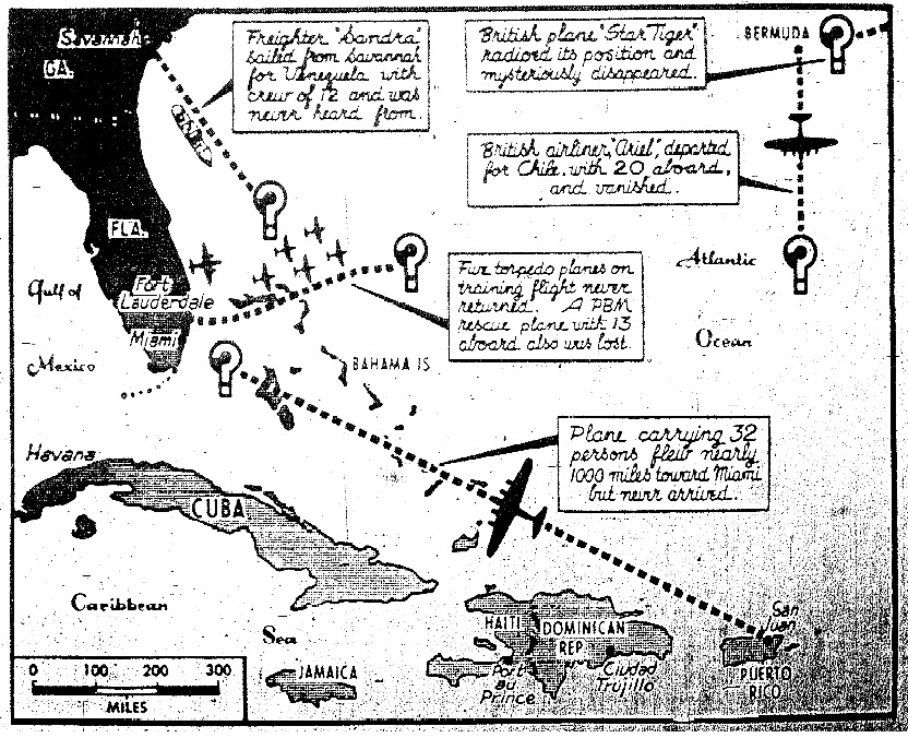
Extra Credit Reading:If you can figure out what happened to those aircrafts and the men who died... you may be able to figure out if the Raleigh Triangle area is going to get snow, ice or freezing rain later this week. Good luck..and get back to me!
http://www.history.com/topics/bermuda-triangle/videos
posted by BobbiStorm @ 7:14 AM
![]()


0 Comments:
Post a Comment
<< Home