Calm Before the Snow... Southern Snow Storm

This is obviously the "Calm Before The Storm" shot as it is flirting with the 50s at 10 AM in Raleigh.

Yesterday was picnic weather and so Weaver Street Market in Carrboro is the best place to go for a picnic on a sunny Sunday afternoon when the forecast for the rest of the week is back to reality...whatever the reality will be. Raleigh never really knows what reality will be until "the low forms off the coast" and the bands of snow show their face on the radar imagery. When people start racing to the store for bread, milk and eggs after seeing the trucks salting the highways. People in Raleigh are NOT believers when it comes to the chance of real Winter Weather... Always burned by storms that dip down and dust Greensboro with snow or southern tracking systems that somehow manage to get snow on the beach at Wrightsville, but leave Raleigh cold and dry.

The paper was all about local news and the Tar Heels beating Clemson and how Russell Wilson is really from Raleigh too.. he left NC State to finish his college football career at Wisconsin. For Raleigh natives Russell Wilson is still a member of the Wolfpack! There is no sign of any winter storm coming this way in the paper today despite that fact that we are due to get about 2 inches of snow and up to 4 as things stand currently beginning on Tuesday just a day away... "Wind chills will be about 5 degrees below zero Wednesday morning" is the line on the Weather Radio ...but who listens to the Weather Radio anymore aside from weather nuts like me??
National Weather Service in Raleigh has issued a Winter Storm Watch.
IMPORTANT NOTE THIS STORM WILL IMPACT TRAVEL ON I-95 ...if you are planning on traveling between Jax and the VA line... pay attention to changing weather warnings and adjust your travel times accordingly. And...yes... will impact air travel in this region!
WRAL is covering it online and all eyes will be on Greg Fishel tonight to see what the local Weather Guru has to say.

Understand in Raleigh if it snows just a light dusting at rush hour gridlock on the highways can shut down the whole city. Honest.. I am not making this up.
http://raleighskyline.com/content/2006/11/21/the-half-inch-of-snow-that-paralyzed-raleigh/
It happens... doesn't happen often, but it happens.
The Weather Channel's latest map for possible winter effects from this storm:

Note with wind chills for Thursday Morning of 5 degrees in Raleigh and temperatures below freezing for a few days... any snow that falls on Tuesday Night and Wednesday IS sticking to the ground. Yes, Virginia... it really can snow in Raleigh... but rarely.

As always the forecast is subject to change with regard to specifics ...because this Snow Cane has not formed yet and won't form until sometime tomorrow. Until it forms... we aren't sure if it forms closer to the coast or further from the coast and if that snow band forecast map above will be moved to the left or to the right. Telling you.. makes forecasting tropical cyclones seem easy...
Let's go wide now... Again, I like to start local and then focus on the bigger picture.

That 's a large area of the Deep South experiencing snow....
 Donald Hovis Jr.
@JimCantore BEST Way to begin the Week! Sunrise along the Grand Strand @2ndavepiermb #MYR #MyrtleBeach #Sunrise pic.twitter.com/VfdWlWrkQB
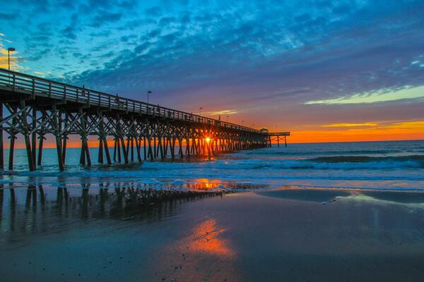


Sweet shot. Should be snow covered in 30hrs MT @dhovismb: #Sunrise along the Grand Strand @2ndavepiermb #MyrtleBeach pic.twitter.com/uIEDtLEyod
 Jim Cantore
 Lots of beaches are going to get snow this week. Note Cantore's comment... should be covered in 30 hours!

Wrightsville Beach
Topsail
Myrtle Beach
Sullivan Island
Tybee Island
Pick your favorite beach and it has the possibility of getting either a dusting... some icing...or... socked with snow.
From Charleston, SC NW
http://forecast.weather.gov/wwamap/wwatxtget.php?cwa=chs&wwa=winter%20storm%20watch
" ACCUMULATIONS...SNOW ACCUMULATION OF 2 TO PERHAPS 4
  INCHES...ALONG WITH 1/4 TO 1/2 INCH OF ICE.

* IMPACTS...SIGNIFICANT ICE...SNOW AND SLEET ACCUMULATION WILL
  CREATE DANGEROUS OR IMPOSSIBLE DRIVING CONDITIONS FOR EVERYONE
  INCLUDING FIRST RESPONDERS. DAMAGE TO TREES...POWER LINES AND
  EVEN STRUCTURES IS POSSIBLE. WIDESPREAD POWER OUTAGES COULD
  PRODUCE LIFE THREATENING SITUATIONS.

* TIMING...TUESDAY INTO TUESDAY EVENING PRECIPITATION IS EXPECTED
  TO TRANSITION TO FREEZING RAIN AND SLEET AS MUCH COLDER AIR
  SPREADS FROM NORTH TO SOUTH ACROSS THE REGION. THEN...
  PRECIPITATION WILL MIX WITH OR CHANGE TO SNOW TUESDAY NIGHT INTO
  EARLY WEDNESDAY...ESPECIALLY INLAND. PRECIPITATION COULD TAPER
  OFF WEDNESDAY OR COULD LINGER INTO WEDNESDAY NIGHT.

* WIND CHILL READINGS...LOWEST 10 TO 15 LATE TUESDAY NIGHT AND
  EARLY WEDNESDAY.

PRECAUTIONARY/PREPAREDNESS ACTIONS...

NOW IS THE TIME TO PREPARE FOR THIS WINTER STORM. ONCE THE STORM
BEGINS...CONDITIONS WILL DETERIORATE RAPIDLY AND TRAVEL WILL
BECOME DANGEROUS OR IMPOSSIBLE. PREPARE TO REMAIN IN A SAFE
SHELTER WITHOUT ELECTRICITY FOR SEVERAL DAYS. OBTAIN VITAL
SUPPLIES SUCH AS POTABLE WATER...NON-PERISHABLE FOOD...MEDICINE...
BATTERIES...FLASHLIGHTS...A BATTERY POWERED RADIO AND AN
ALTERNATE HEAT SOURCE SUCH AS A GENERATOR...NON- ELECTRIC SPACE
HEATER OR WOOD FOR YOUR FIREPLACE"
Savannah:

Forsyth Park in Snow... that's a WOW. Does happen...
Here's some historical perspective on snow down south...
http://www.wunderground.com/blog/weatherhistorian/snowstorms-in-the-south-an-historical-perspective
http://www.erh.noaa.gov/mhx/EventReviews/19891223/19891223.php
In 1989 Savannah had two inches of snow and Tampa saw snow. Charleston had close to 4 inches. Happens. They say the snow seemed like a sort of soothing blessing after the mess Hugo made a few months earlier.
http://www.thestate.com/2009/12/23/1082222/snow-soothed-hurricane-hugos-wounds.html
Some years are just weather busy... and some years are weather quiet. We are in a busy cycle this year!
I'll be following the storm in real time as it develops. And... there is a real potential of icing in areas that are not prone to icing depending on where the snow line sets up... what melts... what refreezes and what may just end up as an Icy Mess. Again.............until that low DEVELOPS... it's all a Deep South Guessing Game.
Keep watching...
Besos Bobbi
http://spaghettimodels.com (not just about the tropics and has good winter weather links)
Ps... Remember this is a tricky forecast both in location and timing. You can read that in the well written discussion below ...that will be updated later today and could include a Winter Warning for Raleigh and that works with other cities also in the watch area such as Atlanta, Savannah...
http://forecast.weather.gov/product.php?site=NWS&issuedby=RAH&product=AFD&format=ci&version=1&glossary=0&highlight=off
AS OF 3 AM MONDAY...

...WINTER STORM POSSIBLE LATE TUESDAY INTO WEDNESDAY...

TUESDAY THROUGH WEDNESDAY: ARCTIC HIGH PRESSURE WILL CONTINUE
BUILDING INTO THE AREA ON TUESDAY AT THE SURFACE. MEANWHILE A
NORTHERN STREAM S/W IS EXPECTED TO TRACK FROM THE PLAINS TO THE
MS/OH/TN VALLEYS. THIS WILL HELP DRAW MOISTURE NORTHWARD FROM THE
GULF OF MEXICO AND HELP TO GENERATE A SURFACE LOW ALONG THE STALLED
ARCTIC BOUNDARY OFFSHORE OVER THE GULF STREAM. THE NAM AND GFS
CONTINUE TO NOT BE PREFERRED BY WPC AS WPC NOTED THEY APPEAR TOO
AMPLIFIED WITH THE NORTHERN STREAM ENERGY AS IT MOVES INTO THE
MS/OH/TN VALLEYS ON TUESDAY... HELPING TO PHASE/INCORPORATE MORE
SOUTHERN STREAM ENERGY AND MOISTURE FROM THE CLOSED LOW IN NORTHERN
MEXICO DURING THAT TIME (THE GFS AND NAM THAT IS). WPC CONTINUES TO
PREFER A BLEND OF THE 00Z ECMWF AND 00Z UKMET... WHICH HAS A LESS
AMPLIFIED NORTHERN STREAM S/W AND SPREADS LESS PRECIP BACK WESTWARD
ACROSS OUR AREA AND IS MORE PROGRESSIVE. HOWEVER... WITH THAT
SAID.... THE LATEST ECMWF AND WPC GUIDANCE STILL SHOWS A GOOD
AMOUNTS OF PRECIP FALLING FROM LATE AFTERNOON TUESDAY INTO WEDNESDAY
MORNING ACROSS OUR SOUTHEASTERN AND FAR EASTERN COUNTIES. GIVEN BOTH
THE NORTHERN AND SOUTHERN STEAM ENERGY HAVE A LONG WAY YET TO TRAVEL
AND UNCERTAINTY IN HOW FAR WESTWARD THE PRECIP WILL SPREAD (THUS
TRENDING THE FORECAST TO THE ECMWF) WILL ONLY ISSUE A WINTER STORM
WATCH FOR LOCATIONS GENERALLY EAST AND SOUTH OF RALEIGH (THIS WILL
INCLUDE WAKE COUNTY THOUGH). THE WINTER STORM WATCH WILL RUN FROM
LATE TUESDAY AFTERNOON UNTIL WEDNESDAY AFTERNOON (ALTHOUGH IF THE
ECMWF IS CORRECT THE SNOW WOULD END ACROSS THE AREA WEDNESDAY
MORNING). WILL MENTION 2-5 INCH ACCUMULATIONS FOR THE WATCH AREA...
WITH LOCALLY HIGHER AMOUNTS POSSIBLE ACROSS OUR FAR SOUTHEASTERN
COUNTIES (SAMPSON... WAYNE... AND CUMBERLAND). GIVEN THE COLD AIR IN
PLACE... PARTIAL THICKNESSES AND MODEL SOUNDINGS GENERALLY KEEP THE
ENTIRE AREA IN THE ALL SNOW CATEGORY... WITH MAYBE A BRIEF MIX
ACROSS FAR SOUTHERN SAMPSON (SNOW/SLEET). WILL STILL SHOW THE MAIN
MAIN TIME FOR ACCUMULATING SNOW/HIGHEST POPS FROM TUESDAY EVENING
INTO EARLY WEDNESDAY MORNING.
posted by BobbiStorm @ 8:34 AM
![]()


0 Comments:
Post a Comment
<< Home