Karen & The Cold Front... Yellow & Orange Fall Circles in the Atlantic
Let's have some orange juice for brunch. Check out the "rolls" trying to form in the Orange Juice Loop:

Both areas highlighted by the NHC have a rolly, polly signature. There is a more complicated, technical way to say this but I'm in a good mood... silly mood so let's go with that description. It gets the point across.
Either it rolls or it's dead in the tropics. A tropical cyclone is a closed low. Then again so is that massive Upper Level Low in the North Atlantic...but it's not tropical.
The local weather people here in NC spent a lot of time trying to explain that the weather yesterday was not connected with the Karen. True and False. Don't you hate those tests? I know I do. I always want to make a case for each answer. Normally we don't get a humid, heavy feel to the air.... the air filters somehow north and mixes in to the Cold Fronts this time of year.. sometimes....when there is a Tropical Entity to the SW of us.
Water Vapor Loop

Incredible games last night. Football and Baseball. All four teams played their asses off if I may say so.
As much as I am a BIG, HUGE Red Sox Fan...got to give it to the Tampa Bay Rays... incredible end to a fantastic game.
See... that time of year when baseball and football share the screen and tropical weather mixes up infusing Cold Fronts with that special something.
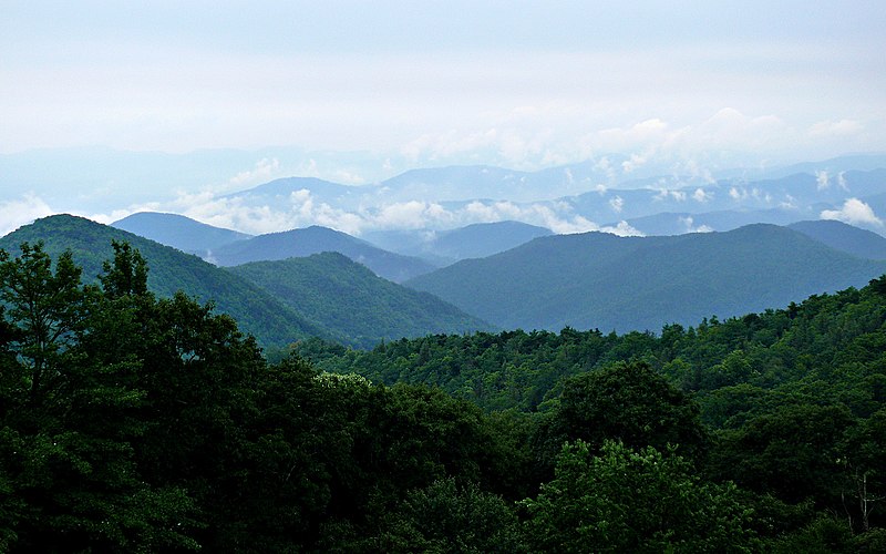
Why are the Blue Ridge Mountains Blue? Read on... same reason it is tropical and cold at the same time up here this morning.
http://en.wikipedia.org/wiki/Blue_Ridge_Mountains
You can look at this loop and see how Karen's remnants merged with the front and are back in the Atlantic off the coast of Florida. It's worth noting that her circulation could be watched in tact as she crossed Florida yesterday.
You can also see the swirl off the Eastern Coast that has a current 10% chance of developing.
As always this time of year you watch any remnants of any front and any other weather system. This year of tropical storms that have been reborn... it's always worth watching.
You can see the frontal boundaries and the Atlantic Swirls below.

Going down into the clouds, below the visible when you slice and dice up the weather you can see where the strongest weather is in this image below.

Remember energy rarely disappears but transfers... it's sort of like money. People invest money in Real Estate, the market drops.... they take their money out. It doesn't disappear they put it somewhere else. Same with weather... moisture and wind. It's always flowing somewhere faster and some places slower than in other places somewhere while you sleep.

The system out in the Atlantic doesn't look fantastic on the Enhanced IR above but it has higher chances down the road of forming into a tropical system. Hey...it's there and the dust isn't...
This year's October is the new September.
Weather is a matter of perspective... like sports. If you are a Red Sox fan.. it was a heartbreaking game last night. If you are a Rays fan it was one of the best games you ever watched.
Easy to say remnants of Karen are not worth talking about. If you live somewhere between Daytona Beach and Tybee Island or places north it is YOUR business if you are a fisherman or a surfer or a person who loves to hang at the beach and watch the waves.
Jacksonville NWS Forecast.
THE REMNANTS OF KAREN WILL BE THE MAIN WEATHER FEATURE AFFECTING
THE REGION DURING THIS PERIOD. MODELS SLOWLY MOVE THIS LOW JUST
TO THE EAST TODAY THEN TRACK IT FURTHER AWAY WEDNESDAY. ENERGY
WILL PIVOT AROUND THE BACK SIDE OF THIS LOW ACROSS THE REGION
TODAY BRINGING SCATTERED SHOWERS...WITH MAINLY THE COAST AND
MARINE WATERS BEING AFFECTED BY SHOWERS ON WEDNESDAY. WITH THE
SHOWERS EXPECTED TO BE BANDED AT TIMES TODAY...LOCALLY HEAVY
RAINFALL WILL BE POSSIBLE...ESPECIALLY NEAR THE COAST.
When the moisture associated with the tropical energy in the Gulf began to filter up into our area the mist in the morning increased as well as the humidity during the day.
It rarely looks like this....but it did on Friday as Karen pumped up tropical moisture into our region.

It looked almost like smoke moving across the street... but it was that misty blue look that you usually see further north in the Smokies or their foothills.
Fall has come to our Cul de Sac... so as a touch of tropical weather. It's a nice mix.
And, baseball and football are sharing the show on TV as well as NASCAR and College Sports.
Tropical Fall is like a Hurricane Sushi Roll and a cup of Chowder for dinner..
Besos Bobbi
Ps... Watch the new wave moving into the Caribbean... just for fun, it's that time of year.

posted by BobbiStorm @ 6:18 AM
![]()


0 Comments:
Post a Comment
<< Home