2013 - How It's a Similar Pattern to 2005. And, a look back at storms that form close in.. past 65 West. Vintage Bobbi Storm

See the visible...there is dust across the basin and a lack of tropical formation.
Messy, busy, swirly water vapor loop.

Hint:
Watch close in for development in the Gulf of Mexico or off the East Coast of Florida.
Check out that diving Upper Level Low and what is left of the frontal boundary.
The ups and downs of a year like this year can make a weather forecaster crazy. So crazy that I realized the best place to find information on the year 2005 was in my own blog.
Jim Cantore posted a picture that has been floating around Twitter all day. Sunrise in New Orleans.
Does it look familiar? A lot like Miami Beach?
Can you say Saharan Dust just after you use the hashtag #NOFILTER ??
So I asked him if there was Saharan Dust. His always witty response was:
@BobbiStorm cough cough
This annoying pattern and the dust which luckily I am north of not dealing with for a change has made me focus my research today on the year 2005. No, I did not say this is a Remake of the 2005 Hurricane Season...just saying there are similarities in the pattern ...especially the dust ...
2013:
All signs are go for a strong hurricane season but we have a pesky Upper Level Low that has taken up residence in the Gulf or the Bahamas any given day dancing back and forth across South Florida. Dust is of epic proportions in the Atlantic so despite strong early waves, they get the life sucked out of them until they make it across the ocean and try to fight off the Upper Level Lows. Fronts dip down leaving tantalizing tails in the tropics just off shore almost close enough for the lifeguards on the beach to see them daily and left over moisture from what is left of a departing tropical depression.
Where there's a way and some where, some how some things got to give... and give it will pretty darn soon. When I say soon.. I mean you may have to wait a week or two, but things will start to snap, crackle and pop and storms will get named fast and possibly closer in than we think.
How do I know this?
History repeats when there are similar patterns.
Let's take 2005 for instance.
1) The waves had a hard time getting across early in the season due to an extremely large amount of Saharan Dust.
2) There were pesky Upper Level Lows chopping up the smooth tropical flow around Florida Also causing a lot of shear..
3) There were lingering frontal boundaries which is why we had so many land falling storms.
4) There was a very strong Atlantic High...so what did form and stayed weak because of the dust moved west towards Florida and PR.
5) There were remnants of tropical depressions that wouldn't go away.. mixing with the lingering frontal boundaries and...
6) Upper Level Lows with entrained moisture in them trying to work their way down to the surface.
7) A lot of storms formed close in ...because they were deprived of the necessary nutrients out in the Atlantic mostly being MOISTURE and a slower flow around the strong high.
Let's take a look at a few examples.
If you look at the very busy map of 2004 and BREAK IT DOWN... you will see that the storms in the distant Atlantic were later in the season... way later.. like December.

Take Zeta and Delta away as well as Lee and Maria and Phillippe. Note Irene did form and went NW fast. Oh...there was Vince... poor, poor never forgotten Vince.
The traffic jam in the Atlantic Basin early in the real season (July, August, September, October) was in the Western Caribbean and the Western Atlantic. Draw a line around 70 West...with the exception of Emily.
Arlene started down in the Caribbean and went north catching a frontal boundary like many a storm before her.

Let's look at Franklin, a storm that beautifully traced the East Coast including tracing the Outer Banks on it's track. Never strong, a bit stronger than Dorian was when the same track was laid out after her second or third reincarnation. And, remember in 2005 they named storms much slower than they do now. Sorry, it's true.. not going to argue it. I was there..

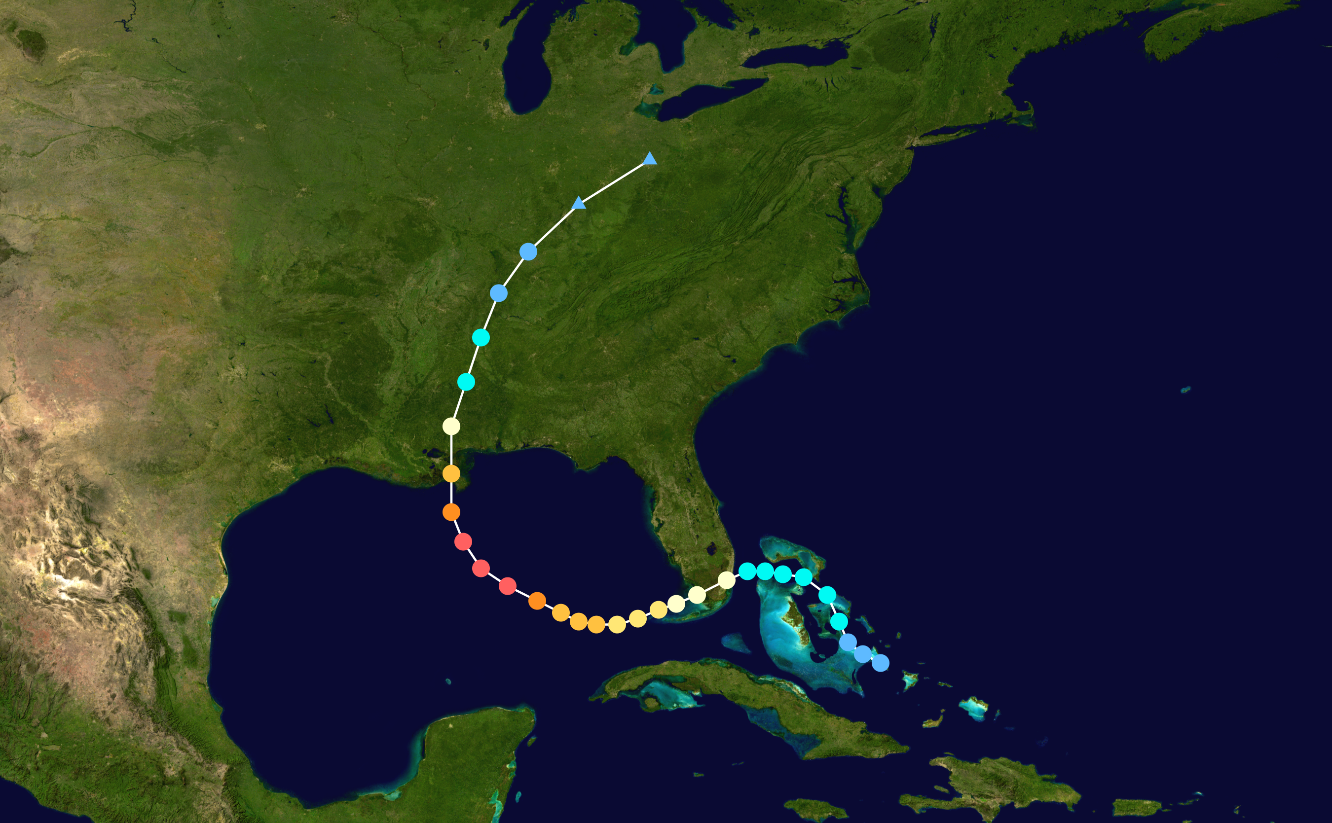
Let's move on to a storm that formed close in ...off shore of Miami with very little official lead time named Katrina. Back when we called if affectionately Kat. She formed from a tropical wave mixing with a pesky ULL and the remnants of Tropical Depression 10 out of what seemed like a whole lot of convection off shore. Originally we were worried on a fast forming Tropical Storm...then it fast became a Hurricane. This was way back when Miami thought of Katrina as their storm vs getting lost in the shuffle after it hit the Gulf Coast and the failure of the levee system in New Orleans.
Hmnnnnn ... how similar is that set up to this year? NOT EXACTLY THE SAME. But, similarities exist.
The third sister that rocked our world that year was Wilma...

Note none of these storms came rolling off the coast like Hurricane Donna in 1960.

The reason they did not was not for lack of trying... but the waves could not get it going because of the dry Saharan Dust and the fast flow around the high and the pesky Upper Level Lows. They formed closed in... in the Caribbean...off the coast of South Florida and yet they were just as memorable as those storms like Donna that rolled off of Africa spinning in a more friendly Atlantic that was more conducive to development far out vs close in.
Every year is different, there are similarities this year to 2005.
1996 was friendly to Atlantic Spinners.

1935 the Atlantic was obviously NOT user friendly for tropical waves.

And, the one commonality with all storms is that weather conditions change and suddenly something happens that kicks a quiet struggling tropical depression into a strong Tropical Storm and Hurricane. Such a case is Betsy in 1965. Note until 65 she was weak... very weak and she didn't look like she was going to make it..and then she did.

History is littered with the storms that did better further west. Look at Irene.

Let's go back to Miami Hurricanes. The University of Miami was born in 1926, it's school mascot named the Ibis after the beautiful white bird that leaves before hurricanes and is the first to return. UM... THE U... it's football team named the Hurricanes because of THE Hurricane...the Queen of Miami Hurricanes. The Great Miami Hurricane. Obviously it formed from a Cape Verde Wave... but it didn't get it together until it passed 65 W.

And, the Big Daddy of Miami Hurricanes...Andrew... never really got it together until after it passed 60 W and then it never looked back... across Florida pushed by the strong Bermuda High and a second trademark landfall along the Gulf Coast.

And, then it did and never looked back.
You see the pattern?
Different decades... different set ups all similar but all a bit different...same result.
1935
1965
1992
2005
The list could go on and on... Florida and then they follow the high into the Gulf of Mexico looking for that open door...that weakness in the ridge where they can go north.
What will 2013 bring? Hard to say for sure, but the strong high is a huge constant and development closer in is also a strong possibility. Frontal boundaries exist leaving the door open to a hit along the Gulf Coast and possibly South Florida. That could change...
Keep watching.
The Canadian and the GFS are showing some development of a Cape Verde Wave in about 140 or 180 hours.
There is some talk of a close in system forming off the coast of Florida in a week or so from the mess of moisture that has been sitting there now from the remnants of an old front and what Dorian left behind.
As for my blog... back in 2005 this time of year I had run off to Key West ... started painting my bedroom and the backroom and I was restless. I was born restless.
NOTHING was going on...
Anything going on out there today? Some moisture off the coast of South Florida... the East Coast. Atlantic covered in dust. Some Upper Level Lows and dipping Fronts...

Besos Bobbi
Ps... A look back at some old posts from 2005... look if you dare and I may not read them too carefully. I was silly... a lot of cray cray things were going on in my life ;)
http://hurricaneharbor.blogspot.com/2005/08/good-shabbos-nothing-going-on.html
Friday, August 19, 2005
Good Shabbos. Nothing going on tropically.. Have a Nice Weekend
Going to read lots of books I got on sale on clearance table at Barnes and Noble. Imagine they need to get rid of merchandise now for Christmas sales and Calendars. May go back.. need more time.. lots of stuff.
Making Fish.. and guacamole (avocado season in Miami, babaganus, Israeli Salad, maybe Cucumber Salad.
Chicken and Rice with sauteed various summer squash and onions and garlic and green pepper. Some vegetable ..whatever I see or inspires me.
Cholent.. Egg Salad, Baby Potato Salad..
Stuff.
Nothing going on tropically. Mother Nature having one good long laugh at NOAA and Dr. Gray before we go into the traditional stronger part of the season Come September. Now there is a good, old, old movie.
September Remember.
August a Bust.
I was watching waves and the area of disturbed weather that became Katrina before the advisories were first posted.
Sunday, August 21, 2005
African Wave Sunday
African Wave...still too close to Africa to figure out what it will do when it sits and spins a bit. Hard not to watch. So hard. Looks so pretty sitting there.
http://www.intellicast.com/Local/USNationalWide.asp?loc=usa&seg=LocalWeather&prodgrp=SatelliteImagery&product=Atlantic&prodnav=none
Great color on this satellite site. Might be old compared to the newer fancier ones but still...high definition, great color.
Speaking of color. Trying desperately not to go to Home Depot today and find some paint to paint my backroom a different color. Did this last paint job on the day of the elections.. bush/kerry. Hate it. It's a big room. Big job and not the wishy washy type who would go out and paint one little area one color like they were tasting some forbidden sweet but can't commit to it... and can't decide. Not much Libra in my chart. Have this overwhelming desire the last few days to paint it yellow, pale yellow... drop of honey in it in but not bright. Mind you this is wierd as I am not a yellow peson. Feel like suddenly I need it to be warm, soft yellow. Go figure. It's a sky blue sort of turquoise color right now. Doesn't have enough green and is too dark to be the color in my room...reminds me of a dress I had when I was 16. I hate the color. May just paint today.. who knows
My mind is too fragmentated to think today.
The joy of reading DaVinci Code yesterday was that I read ONE book. One thing. My mind focused. Usually it flits around from site to site, place to place, request to request..thing to thing.
I need to focus more. Pick a subject of the day and go with it.
Otherwise it's like wandering around a Pic N Save in California looking for something to catch your attention. In the old days. 80s. Was the place to be wasn't it? And, oh what a place it was.
Bobbi
THREE DAYS LATER.... Suddenly Katrina.... but first look at the first warnings...
Morning of August 23, 2005...oh LOOK I was singing Jimmy Buffett Tunes...........hmnnnn
Tuesday, August 23, 2005
WWJBD
Cause my mouth is wide open even if my fingers are tapping and my hips are about to be swaying cause am going to get up, dance my way into some clothes and hit the road.
I can't figure it out. Just when you think you have seen everything...this wave splits into two seperate looking entities. Reminds me of scene in White Christmas where Bing Crosby asks Danny Kaye about those blue eyes on that girl and Danny replies brown... or vice versa. Can't believe I just typed that ... must be the JB getting to me.
So... last night I was wondering if that finger from the nasty looking high with all the little upper level lows at the ends of it's tentacles http://weather.unisys.com/satellite/sat_wv_east_loop-12.html
would just grab the top part of the wave and wisk it away leaving the bottom part to develop. Knew it would look great as the ull would enhance it into something looking like a full fledged TS.. but didn't expect it to look soooooo good.
So, went to bed last night with images of the models dancing in my head. Know they change a lot... especially when we don't have a bonafide center to iniatilize the models from...
Well...now we might have two.. is that possible? Am sure it has happened before. Everything has happened in the tropical basin even if we don't know about it. Oh Yes Virginia.. even before Global Warming...
So... could the top half of the wave develop into a closed low core system? My money is that the old remnants are down on the Cuban coast in what is a more round concentrated center on enhanced IR.
Waiting to see what the planes say..
Jose making landfall..stronger at the last minute than anyone expected possibly but still just a TS. Mind you that may be more than TD can aspire to
The African Wave... okay ... I see why "my friend" doesn't like it.. it is way too north, fishy beyond words and not going to buy into anything there til the dust queen lets go ...
Sun is up... a quiet pretty sunrise in Miami with low level color. Mauvey..hazy.. golden with pinks inside like the inside of a conch shell..
WWJBD... I'm in the mood to get away... pour me a vacation, I need to leave here right away...
So... woke up at 5:04 and couldn't sleep.. tried... 5:15 tried to give it up but decided to stay in bed... weather radio was still playing the 10:30 tropical discussion and the sky was still dark. Gave it up.. looked at the clock and knew what time it was...how do I do that? 5:49.. put on update and missed the part on the wave... gave up... gonna be one of those days I see..
Am no longer in control of my mind it seems sometimes... I just rent it. Someone else owns it.
Getting coffee and getting out of here. Imagine Jimmy would go fishing... and figure by the time he gets back the planes would get their data and he'd have a fish or two.
Maybe thats Ernest and Scott down there...Scott flying off to far away places and Ernest hanging close to the coast of Cuba.
Will see.. Won't we...
Looking forward by weeks end to having something more to track and to listening to tracs of the Beatles, the Monkees and Hermans Hermits.
Not my first choice mind you... quite insane, i think it hurts my brain..
Old songs, straight from the heart.
Time to close the shutters, time to go inside.. in a week I'll be in Gay Paree and that's a mighty long airplane ride... see... Jimmy always loved Fitzgerald, proof in the pudding is Diamond As Big As the Ritz :)
Gatsby never realized or understood he had Daisy's heart from the start. He didn't have fly off to be someone... he didn't have to change his name.. he didn't have to build a mansion on the Island.. she loved him right from the start.. he ran off to make his fortune and change his name for himself... to quiet some monster inside him that wouldn't rest... he just used Daisy as an excuse because on that moonlit porch... he had her... Like most southern girls.. she talked too much... but Gatsby being from "up north" in a place where they have Winter Dreams didn't know what good old Southern Boys know... GRAB THE GIRL AND KISS HER, and take her for a long ride...on a winnebago or a sailboat... or a houseboat... or in a trailer.
Just do it!
Don't sing about it..that's what Jimmy Buffett would do... do it...
going to listen to the other JB and get out of here... already did HurricaneCity and glanced through (rolling eyes, grrrrr) cyclone's old favorite... flhurricane.com.
Bobbi.. later...
Tuesday, August 23, 2005
Tropical Storm Watch Issued For South Florida
At 11 PM EDT... 0300z... a tropical storm watch has been issued for
portions of the East Coast of Florida and the Florida Keys from
west of the Seven Mile Bridge northward to Vero Beach. A tropical
storm watch means that tropical storm conditions are
possible within the watch area...generally within 36 hours.
So...we sit and we wait for Katrina to be born... figuring here that this is Katrina and she won't collapse over night.
Have not much to add other than anything could happen. She could muddle around out there, move in slowly.. dump lots of rain and cause severe localized flooding or she could ramp up into a Cat 1 Hurricane just before landfall.
The proof is in the pudding and the pudding is not being made until later tomorrow morning. Til then we don't know what we have and we are waiting to find out.
As for me.. well, not panicking. Barely going to do much.. buy some soda, graham crackers, rice cakes, pnut butter and let her blow.. sit back and watch. No energy to do much else and for now.. want to enjoy it all a bit... if it gets its act together faster rather than later.. will ramp up those plans a bit.
For now... we have a Tropical Storm Watch.
Katrina simmering around like a good Jambalya Stew..
On a personal note.. my brother was in Hallandale this morning working and he got into TWO car accidents..he is fine. His car isn't and imagine he will end up feeling like he was in 2 car accidents tomorrow. Some 98 year old lady hit him in the trunk on the side (no Neil Rogers jokes) and then an hour or two later some big dude in a big Mercedes slammed into him and told the cop a piece of paper fell out of the visor temporarily blinding him and totally smashing the whole rear end of his small car. He is fine..says he is. Didn't get tickets.. But, just goes to show you .. you wake up one morning and think it will be a normal, perfect day.. or crummy day..regular day and then all hell breaks loose and well... you never know how tomorrow will end up so you better enjoy today.. while you can. Makes you think, doesn't it? Crazy... Best friend said sounds like Hallandale has bad vibes and might get the center (if we ever find it) of Katrina.. Butterfly wings theory.
Nite.. Bobbi
Wednesday, August 24, 2005
Miami NWS Second Guessing Track & Foward Speed
Notice rudenmentary banding features pulling together fast. Kat will be a hurricane before landfall.. if current trend continues.. if not by tonight.
Something to think on.
Bought some tuna on sale at Walgreens and some Teddy Graham Cracker Cookies... making small list for shopping later. Checked supplies and lo and behold there are still AA batteries in the house..wow..amazing.
Guess I'll take in the paint cans and crap in the backyard.. wouldn't for a small TS but this is not going to stay the way it is..
And, for now.. all bets are off on timing.. If pocket around the storm continues to fill in and banding begins... it's over hot hot water.. HOT.
Miami watch out.. it's closer than we think as all the News people have not been brought up to speed on developments. Noon News should surprise a lot of people.
Not saying Major Cane here but definitely looks like Cane Time in Miami..
Stay tuned...
"LATEST GFS BRINGS IT ACROSS SOUTH FLORIDA LATE FRIDAY
MOVING IT VERY SLOWLY AND THEN TAKES IT NORTH AS WE MOVE INTO THE
LATTER PART OF THE WEEKEND. HOWEVER...SEEMS THIS SCENARIO IS LESS
LIKELY AT THIS TIME GIVEN UPR LVL RIDGE TO THE NORTH MIGHT BE
BEGINNING TO BUILD PER PRELIMINARY 06Z SNDG DATA. AND THIS IS IN
LINE WITH CURRENT NHC FCST WHICH BRINGS THE STORM ACROSS SOUTH
FLORIDA THRUSDAY AFTERNOON THROUGH FRIDAY NIGHT."
Wednesday, August 24, 2005
Hurricane Warnings Posted
Storm is really intensifying.. you'd never know it from National Hurricane Center's advisory but it is. Maybe the areas further out aren't so red but the center that is forming is anchoring itself big time. Why is this BIG... this is BIG because once it gets anchored in the center strong... it will intensify in strength over very warm water in the Gulf Stream. It is also I might add as the high kicks in and the steering currents take over... speed up a drop.
I have something odd to say here.. a pet peeve. My blog and I can do that..
Am sick to death of hearing about this area being called the TRI-County Area.
The hell it is.
It is Miami-Dade... or even maybe Miami-Dade/Broward but we are NOT connected to Palm Beach and I notice that it is usually Palm Beach businesses that use the Tri-County Crap which sort of means.. "come on up and visit us.. we aren't that far"
Me and WPB are miles and miles apart in so many ways and we are in different counties...different worlds. Miami/Broward...yeah will buy it because all the Miamians ran north to retire and grow old or raise families up there but West Palm Beach.. you are on your own.
So...
Miamians know how to prepare for a storm..
We go on automatic. We are living in Hurricane Country. Our school is called the University of Miami Canes. I grew up with them..I know what to do.. Either way its a crap shoot if you get the bad part or you get spared.
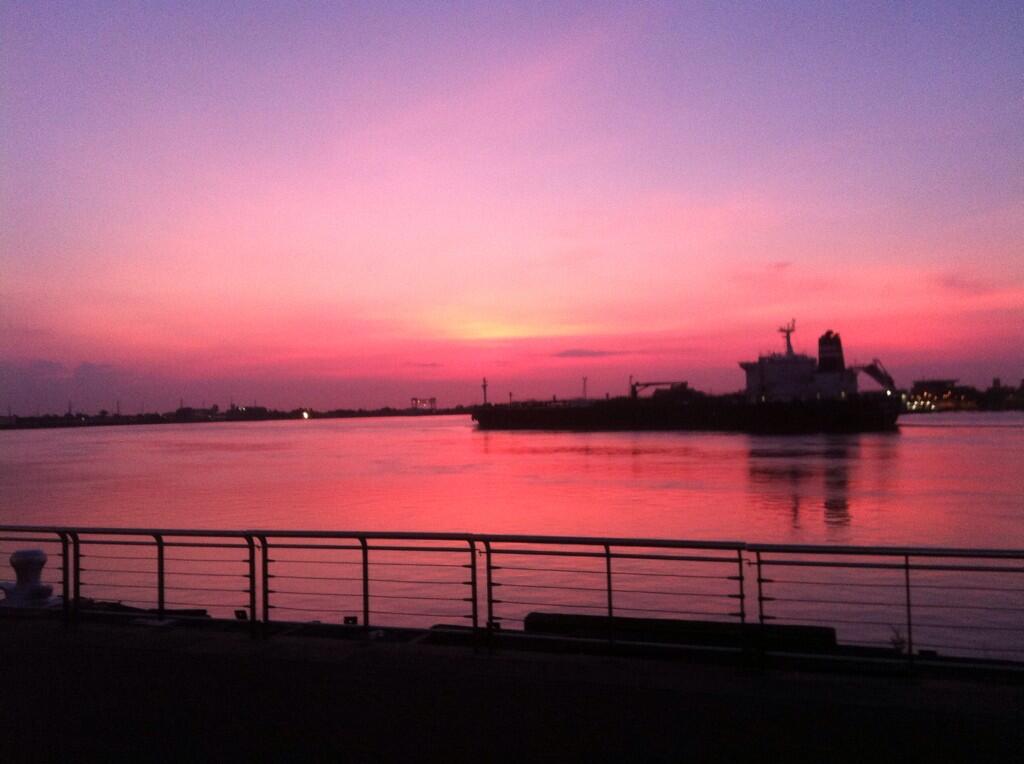
Beautiful sunset tonight.. sky was pink, purple.. the eastern sky and it's big tall clouds turned multi-colored. It was beautiful.
So... 26.0 Hollywood or near CountyLine... with an error of margin that it might drop a drop south. Well... my kids will be thrilled, after we clean up the yard and hunker down they can get a real hurricane and not just a tropical storm like we had by Frances.
Will see...
Keep watching.. see what the big guys say in the big bunker out at my old college.. FIU... let's see what the NHC do with it later... if the dot in the middle intensifies and the storm does in fact become a hurricane.
Night..from Miami
posted by BobbiStorm @ 2:58 PM
![]()


0 Comments:
Post a Comment
<< Home