S for Sandy.. Tropical Storm Forming in the Caribbean
I call this image S for Sandy

Although Invest 99L is currently at a 90% chance of developing into a Tropical Storm the picture above would make me believe we are closer to 100%
Expect an upgrade of some kind at 11 AM, unless they wait to see what the Hurricane Hunters in their flying machines say...but visible imagery is pretty conclusive. It is at the least a Tropical Depression waiting for designation.
The language in the NHC statement says a lot, but satellite loops say more.
SATELLITE IMAGES AND SURFACE OBSERVATIONS INDICATE THAT A TROPICAL
DEPRESSION COULD BE FORMING OVER THE SOUTHWESTERN CARIBBEAN SEA
ABOUT 300 MILES SOUTH OF JAMAICA. THE LOW IS EXPECTED TO BE NEARLY
STATIONARY TODAY AND SHOULD BEGIN TO MOVE NORTHWARD TOWARD JAMAICA
AND EASTERN CUBA ON TUESDAY. THIS SYSTEM HAS A HIGH CHANCE...90
PERCENT...OF BECOMING A TROPICAL CYCLONE DURING THE NEXT 48 HOURS.
HEAVY RAINS FROM THIS DISTURBANCE ARE LIKELY TO SPREAD OVER
JAMAICA...HISPANIOLA...AND EASTERN CUBA DURING THE NEXT SEVERAL
DAYS. THESE RAINS COULD PRODUCE LIFE-THREATENING FLASH FLOODS AND
MUD SLIDES...ESPECIALLY IN AREAS OF HIGH TERRAIN. AN AIR FORCE
RESERVE HURRICANE HUNTER AIRCRAFT IS SCHEDULED TO INVESTIGATE THIS
SYSTEM THIS AFTERNOON.
Also, models show Tropical Storm Sandy can be a possible problem down the road. The short term road takes it to Jamaica and then curves back towards Cuba and Haiti which can and will produce torrential rains. Note that the top part of "Sandy" is large and will affect the Haiti adversely.
Models:
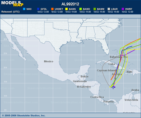
Models come and go, but the Navy track for now says more:

Trust me though... weather people up and down the East Coast are watching this situation closely..
As models have been all over the place... yesterday Nogaps hit Miami
(doubtful, but does make you go "uhhh")

Most likely Sandy will go West, hook north and then NNE or NE into the Bahamas, across the Greater Antilles and then...however the upper air currents are blowing will either go fast out to sea or... stick around and make forecasters scratch their heads and hope their forecasts play out properly.
Keep watching...
Besos Bobbi
Ps If you don't have a lot of time to read long discussion... check out www.spaghettimodels.com this site gets better and better and one quick look shows you what is happening and how the storm is forming, exploding and then you can click onto any link to take you where you want to go..
Love it... makes life so much easier for weather people like me!
And, if you are a NASCAR fan.. he has another great page:
Lastly.... on a personal note.. I told my husband we would need the heater early this year so keep that in mind and he did. The heat came on last night and I have it set really low as I'm not in love with heaters. I have a love/hate relationship with them... but even though I had to take my long sleeve top I was wearing under a little tee shirt off at Martinsville yesterday... as soon as the sun went down I put it back on... got cold fast. It was in the low 40s, flirting with the 30s last night though it's going up to the high 70s today. Fickle Fall I guess? And, as for peak of the season.. hard to see as so many leaves have fallen off the trees still green this year and though a few trees are beautiful... maybe are missing all their leaves.


posted by BobbiStorm @ 7:35 AM
![]()


0 Comments:
Post a Comment
<< Home